Overview
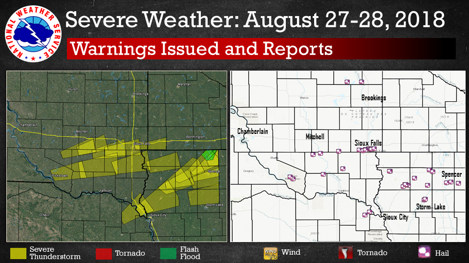
Scattered strong to severe thunderstorms developed across northeast Nebraska and parts of northwest Iowa on Monday, August 27th. These storms began to intensify into severe weather limits early in the afternoon, producing golf ball size hail as it quickly advanced northeast into central Minnesota and Iowa.
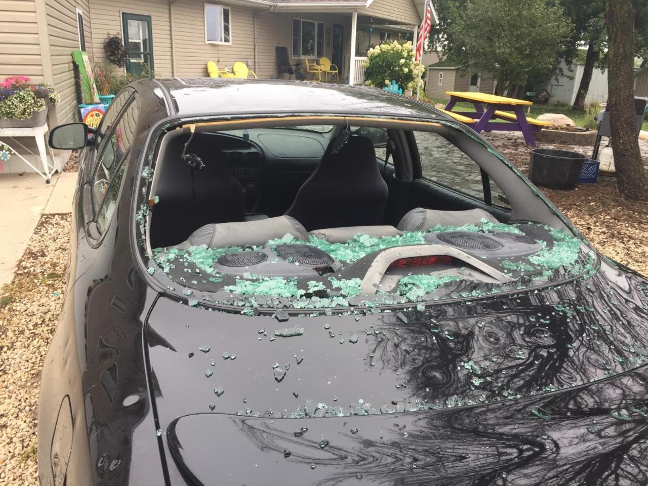
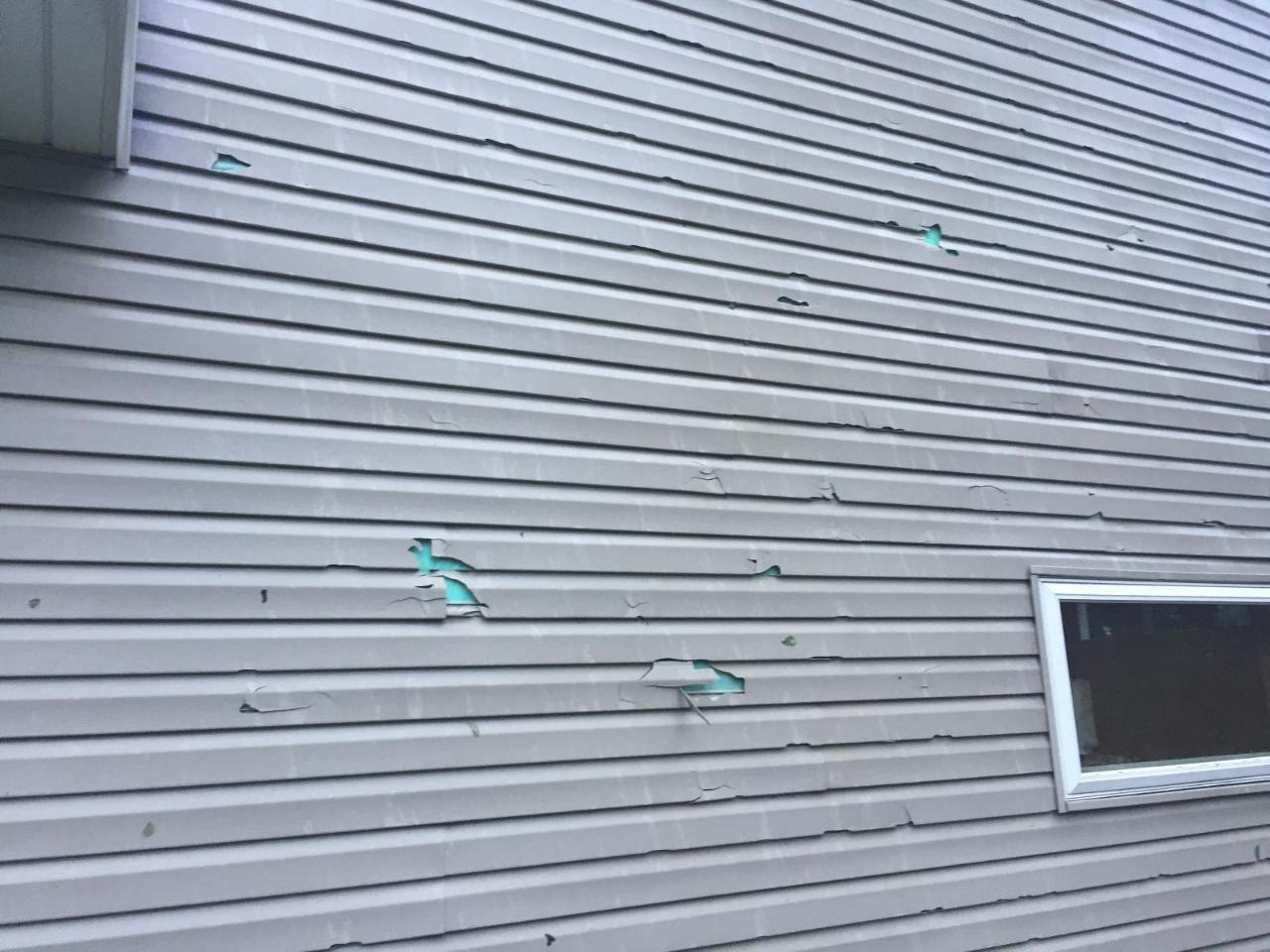
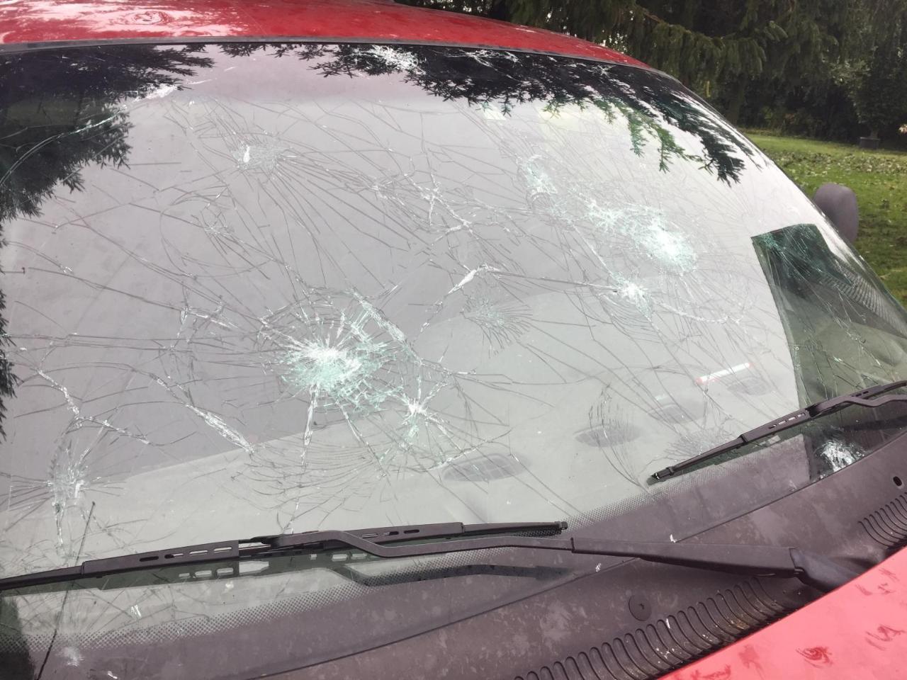
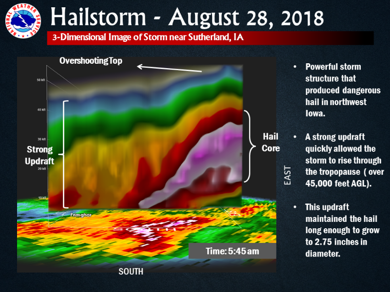
After the evening was finished, isolated thunderstorms moved across south central South Dakota, becoming severe shortly after 1am Tuesday August 28th, impacting southeast South Dakota and northwest Iowa. These storms produced hail as large as golf ball size southwest and east of the Sioux Falls metro area. By around sunrise, additional severe storms developed in northwest Iowa, producing even larger hail of baseballs or slightly larger. These storms produced significant damage to cars, homes and crops near the Primghar and Sutherland areas.
Photos & Video:
 |
 |
 |
 |
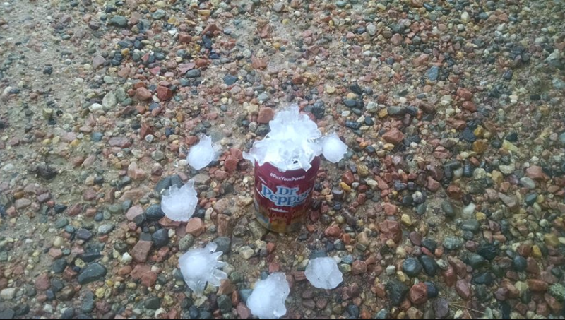
| Hail from storm that passed through Ponca, Nebraska on August 27th (Courtesy of Brian Nelson) |
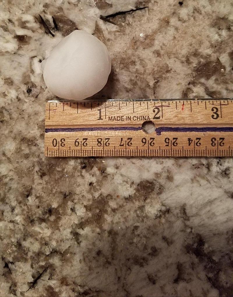
Golf ball size hail reported west of Sioux Falls in August 28th during the overnight hours. (Courtesy of Mike Brenna) |
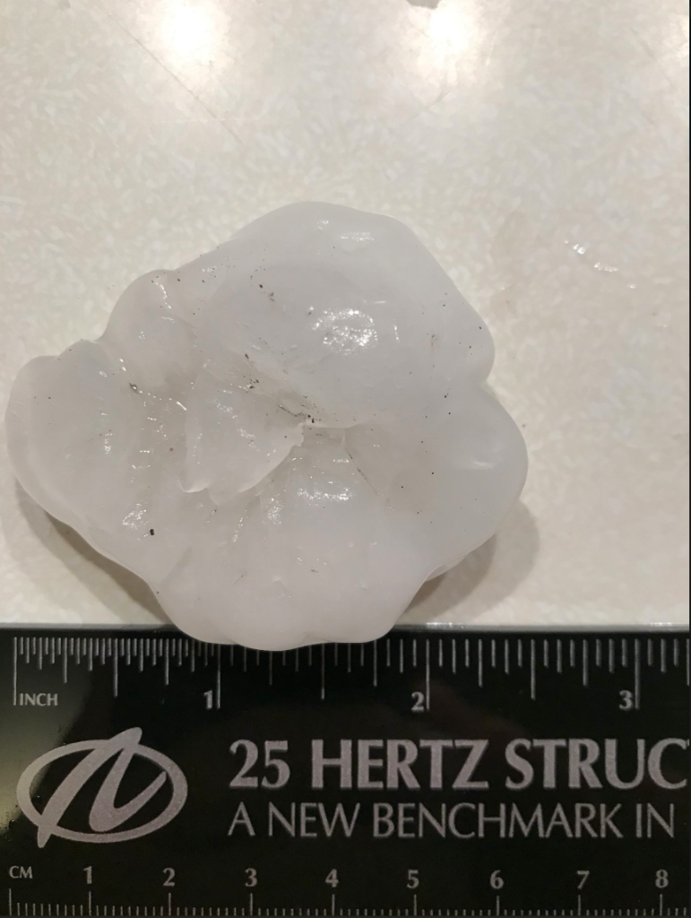
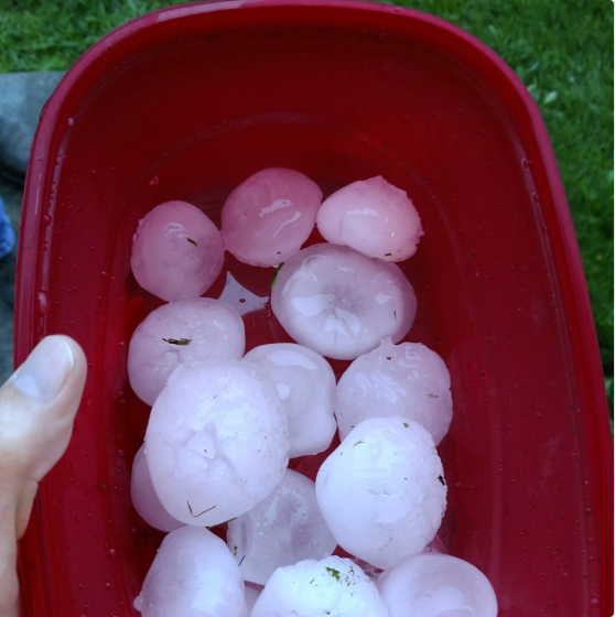
Tennis ball size hail near Cherokee, Iowa during the early morning of August 28th. (Courtesy of Charlie Leissler IV) |
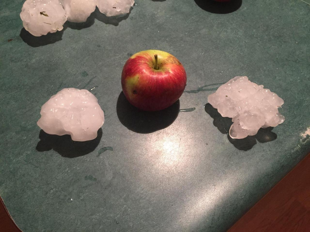
2 to 2.5 inch hail reported in Sutherland, Iowa on August 28th during the early morning. (Courtesy of Ben Maurer) |
sTORM Damage IN SUTHERLAND, IOWA
 |
 |
 |
 |
Radar:
Header
 |
 |
|
First Round of Severe Thunderstorms August 27th, 2018 |
Second Round of Severe Thunderstorms August 28th, 2018 |
 |
 |
 |
|
A 3-D view of the storm that impacted O'Brien County with dangerous large hail around baseball size. |
Closer Radar Look at Severe Thunderstorms over Sutherland/Primghar area
|
Closer Radar Look at Severe Thunderstorms over the Sioux Falls Area |
Storm Reports
..TIME... ...EVENT... ...CITY LOCATION... ...LAT.LON...
..DATE... ....MAG.... ..COUNTY LOCATION..ST.. ...SOURCE....
..REMARKS..
0620 AM Hail 1 NE Cherokee 42.76N 95.54W
08/28/2018 E1.50 inch Cherokee IA Law Enforcement
0620 AM Hail 3 ENE Gillett Grove 43.03N 94.99W
08/28/2018 E1.75 inch Clay IA Trained Spotter
Ping pong to golf ball size hail.
0619 AM Hail 2 W Gillett Grove 43.02N 95.08W
08/28/2018 M1.75 inch Clay IA Trained Spotter
0614 AM Hail Cherokee 42.75N 95.56W
08/28/2018 E1.00 inch Cherokee IA Law Enforcement
0515 AM Hail 3 E Alton 42.99N 95.96W
08/28/2018 E1.50 inch Sioux IA Trained Spotter
Lots of crop damage from half dollar to
silver dollar sized hail.
0436 AM Hail Rock Valley 43.20N 96.30W
08/28/2018 E1.00 inch Sioux IA Trained Spotter
0339 AM Hail 10 SE Freeman 43.24N 97.30W
08/28/2018 E1.25 inch Turner SD Public
Also strong winds, speed unknown.
0332 AM Hail 3 W Wagner 43.08N 98.37W
08/28/2018 E1.00 inch Charles Mix SD Public
Reported via social media. Damage to
vehicles and crops reported.
0330 AM Hail 1 NNW Dolton 43.51N 97.39W
08/28/2018 E1.00 inch McCook SD Trained Spotter
Mostly nickel size but a few stones up to
quarters. Time estimated via radar.
0240 AM Hail 2 S Ravinia 43.11N 98.43W
08/28/2018 E1.00 inch Charles Mix SD Public
0230 AM Hail 4 W Rowena 43.55N 96.63W
08/28/2018 M1.00 inch Minnehaha SD NWS Employee
Considerable about of dime and nickel hail.
Largest was quarter.
0226 AM Hail 4 WNW Rowena 43.55N 96.63W
08/28/2018 M1.00 inch Minnehaha SD NWS Employee
0223 AM Hail 2 E Sioux Falls 43.54N 96.69W
08/28/2018 E1.75 inch Minnehaha SD Public
Mainly quarter to half dollar hail, with a
few golf ball size stones.
0222 AM Hail 2 E Sioux Falls 43.55N 96.69W
08/28/2018 E1.75 inch Minnehaha SD Public
Quarter to golf Ball size hail.
0220 AM Hail 1 ESE Sioux Falls 43.54N 96.70W
08/28/2018 E1.25 inch Minnehaha SD Public
0220 AM Hail 1 ENE Sioux Falls 43.55N 96.71W
08/28/2018 E1.50 inch Minnehaha SD Public
0219 AM Hail 1 W Sioux Falls 43.55N 96.75W
08/28/2018 E1.00 inch Minnehaha SD Trained Spotter
0215 AM Hail 5 W Sioux Falls 43.54N 96.82W
08/28/2018 E1.50 inch Minnehaha SD Public
0214 AM Hail 5 W Sioux Falls 43.53N 96.83W
08/28/2018 M1.00 inch Minnehaha SD Public
0212 AM Hail 5 E Wall Lake 43.52N 96.87W
08/28/2018 E1.75 inch Minnehaha SD Public
0212 AM Hail 5 W Sioux Falls 43.53N 96.82W
08/28/2018 E1.25 inch Minnehaha SD Public
0205 AM Hail 1 NE Wall Lake 43.53N 96.95W
08/28/2018 E1.75 inch Minnehaha SD Public
Hail stripped leaves from trees. social
media video.
0115 AM Hail 6 NE Ramona 44.18N 97.13W
08/28/2018 M1.75 inch Lake SD Public
Minor crop damage.
0115 AM Hail 7 WNW Clayton 43.48N 97.78W
08/28/2018 M1.75 inch Hutchinson SD Public
Minor crop damage. Corrects location from 6
NE of Ramona.
0100 AM Hail 3 ESE Dimock 43.46N 97.94W
08/28/2018 E1.75 inch Hutchinson SD Public
Reported via social media.
0351 PM Hail 2 SW Archer 43.09N 95.77W
08/27/2018 E1.25 inch O'Brien IA Public
Reported via social media.
0343 PM Hail 3 E Alton 42.99N 95.95W
08/27/2018 M1.75 inch Sioux IA Trained Spotter
Hail lasted five minutes, until 3:44 pm.
0339 PM Hail 2 E Alton 42.99N 95.97W
08/27/2018 M1.25 inch Sioux IA Trained Spotter
0333 PM Hail 2 S Alton 42.96N 96.01W
08/27/2018 E1.00 inch Sioux IA Trained Spotter
0330 PM Hail 3 NNE Hartley 43.22N 95.45W
08/27/2018 M1.00 inch O'Brien IA Trained Spotter
0330 PM Hail 4 WNW Everly 43.19N 95.38W
08/27/2018 M1.00 inch Clay IA CO-OP Observer
Corrects previous hail report from 3 NNE
Hartley.
0238 PM Hail 1 W Ponca 42.56N 96.73W
08/27/2018 E1.75 inch Dixon NE Trained Spotter
0229 PM Hail Martinsburg 42.51N 96.83W
08/27/2018 E1.75 inch Dixon NE Trained Spotter
&&


 Weather Story
 Weather Map
 Local Radar