Overview
|
Yet another early spring storm system brought widespread accumulating snow to the region Sunday. The snow came just a day or two after record breaking high and low temperatures occurred. Winds were also gusty, leading to areas of reduced visibility. |
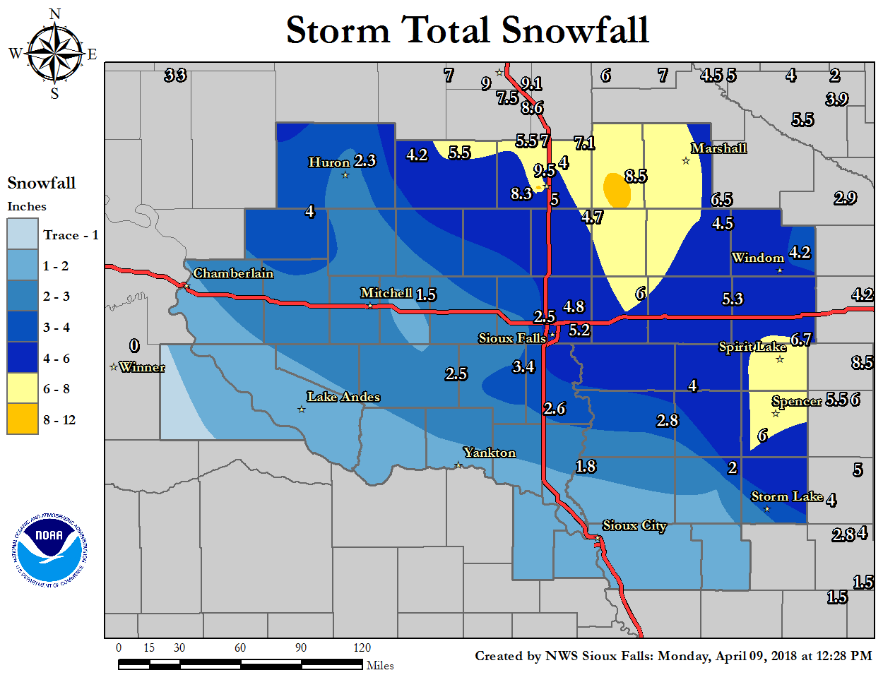 Snowfall Totals from April 8th, 2018 |
Snow/Ice
Location                     Amount    Time/Date       Lat/Lon
3 WSW Brookings              9.5 in    0700 AM 04/09   44.29N/96.84W
Lake Benton                  8.5 in    0700 AM 04/09   44.26N/96.29W
1 SW Brookings               8.3 in    0700 AM 04/09   44.30N/96.80W
Spirit Lake                  6.7 in    0700 AM 04/09   43.42N/95.11W
4 N Currie                   6.5 in    0645 AM 04/09   44.14N/95.68W
Minneota                     6.1 in    0800 AM 04/09   44.56N/95.98W
Peterson                     6.0 in    0700 AM 04/09   42.92N/95.34W
5 W Bruce                    5.5 in    0700 AM 04/09   44.44N/96.99W
Marshall                     5.0 in    0800 AM 04/09   44.45N/95.79W
10 E Nunda                   5.0 in    0700 AM 04/09   44.14N/96.82W
Storm Lake                   5.0 in    0800 AM 04/09   42.65N/95.20W
Sioux Falls NWS              4.8 in    1200 AM 04/09   43.59N/96.73W
Flandreau                    4.7 in    0700 AM 04/09   44.05N/96.60W
1 N Sutherland               4.5 in    0800 AM 04/09   42.98N/95.50W
Bridgewater                  4.5 in    0800 AM 04/09   43.55N/97.50W
Windom                       4.2 in    0700 AM 04/09   43.87N/95.12W
Marion                       4.2 in    0800 AM 04/09   43.42N/97.26W
Sheldon                      4.0 in    0700 AM 04/09   43.18N/95.84W
Rock Valley                  4.0 in    0800 AM 04/09   43.20N/96.30W
2 NE Brookings               4.0 in    0700 AM 04/09   44.33N/96.76W
Lake Wilson                  4.0 in    0800 AM 04/09   43.99N/95.95W
Wessington Springs           4.0 in    0700 AM 04/09   44.08N/98.57W
Sanborn                      3.7 in    0800 AM 04/09   43.18N/95.66W
2 SE Madison                 3.5 in    0900 AM 04/09   43.99N/97.08W
Hurley                       3.4 in    0700 AM 04/09   43.28N/97.09W
Woonsocket                   3.0 in    0800 AM 04/09   44.05N/98.27W
Pipestone                    3.0 in    0800 AM 04/09   44.00N/96.31W
Orange City                  2.8 in    0700 AM 04/09   43.00N/96.06W
Howard                       2.6 in    0800 AM 04/09   44.01N/97.52W
5 WSW Beresford              2.6 in    0700 AM 04/09   43.06N/96.87W
1 NE Wall Lake               2.5 in    0700 AM 04/09   43.54N/96.94W
Cherokee                     2.0 in    0700 AM 04/09   42.75N/95.55W
6 NNE Elk Point              1.8 in    0700 AM 04/09   42.76N/96.64W
Alexandria                   1.5 in    0700 AM 04/09   43.65N/97.78W
White Lake                   1.1 in    0700 AM 04/09   43.73N/98.71W
Radar:
Header
 |
| Radar Loop For Sunday April 8th, 2018 |
 |
Media use of NWS Web News Stories is encouraged! Please acknowledge the NWS as the source of any news information accessed from this site. |
|


 Weather Story
 Weather Map
 Local Radar