Overview
|
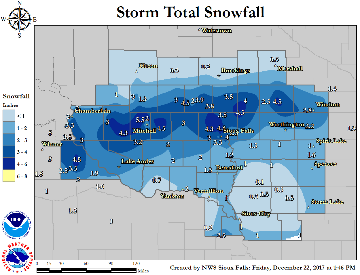
A winter storm moved across the region Thursday, December 21st, 2017, producing widespread snow of 1 to 5 inches across the region. Early in the morning hours, a narrow band of snow started to develop across southeast South Dakota, just north of I-90. As the day progressed, widespread light snow became more dominant as the band slowly shifted southeast into northwest Iowa during the evening hours. The heaviest snow amounts fell from Gregory, SD to Mitchell, SD to Pipestone, MN. Sioux Falls metro area received from 3 to 4 inches of snow. |
 |
 |
 |
 |
|
Storm Total Snowfall Map Highest snow amounts across southeast South Dakota and southwest Iowa. |
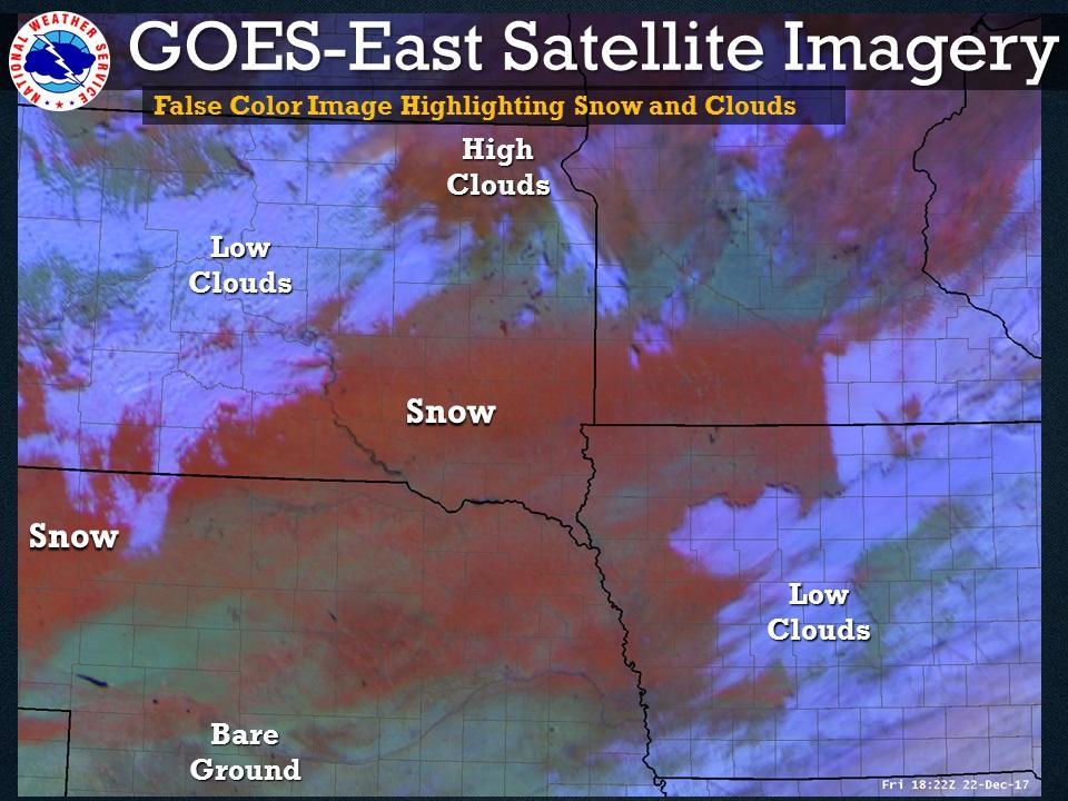
Satellite imagery from GOES-East highlighting areas of snow (red color) across the region. |
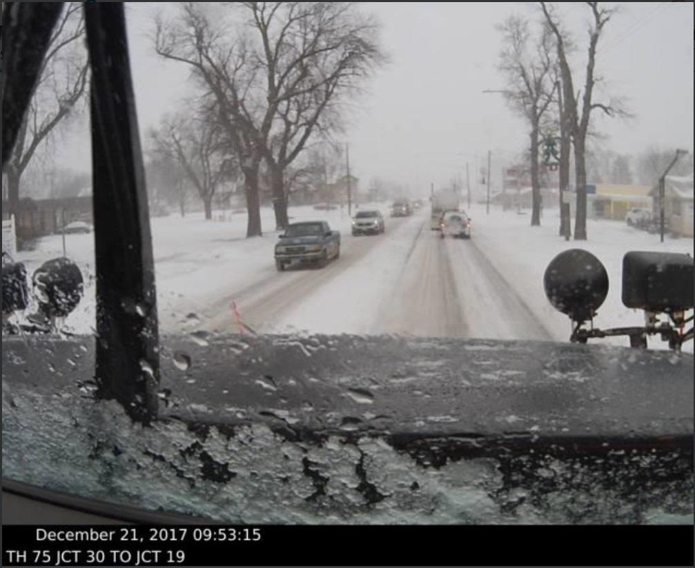
A view of snow falling Pipestone, MN in the morning. This location received from 3 to 4 inches of snow.
|
Radar:
Header
|
 |
|
Radar Loop - Precipitation Type 9 am to 3 pm Thursday |
Radar Loop - Reflectivity 9 am to 3 pm Thursday |
Storm Reports
Location                     Amount    Time/Date       Provider

...Iowa...

...Buena Vista County...
2 E Storm Lake               1.0 in    0800 AM 12/22   COOP

...Cherokee County...
Cherokee                     0.5 in    0800 AM 12/22   COOP
4 N Cleghorn                 0.5 in    0700 AM 12/22   COCORAHS

...Dickinson County...
Milford                      1.6 in    0850 PM 12/21
Vicks Corner-spirit Lake Iow 1.0 in    1200 AM 12/22   UCOOP

...Ida County...
3 SSW Arthur                 1.0 in    0546 AM 12/22   COCORAHS

...Lyon County...
Rock Rapids                  1.5 in    0800 AM 12/22   COOP

...O'Brien County...
Sheldon                      1.0 in    0700 AM 12/22   COOP

...Osceola County...
Sibley                       1.0 in    0700 AM 12/22   COOP

...Plymouth County...
Remsen No. 2                 0.5 in    1000 AM 12/22   COOP
Le Mars                      0.3 in    0700 AM 12/22   COCORAHS

...Sioux County...
Rock Valley                  1.0 in    0700 AM 12/22   COOP
Hospers                      0.6 in    0536 AM 12/22
2 S Orange City              0.1 in    0800 AM 12/22   COCORAHS
Orange City                  0.1 in    0700 AM 12/22   COOP

...Woodbury County...
Holly Springs 1nw            1.0 in    0700 AM 12/22   COOP
Sioux Gateway Airport        1.0 in    0552 AM 12/22   ASOS
Sergeant Bluff               0.8 in    1150 PM 12/21

...Minnesota...

...Cottonwood County...
2 WNW Windom                 2.8 in    0800 AM 12/22   HADS

...Jackson County...
Lakefield                    2.2 in    0700 AM 12/22   COOP

...Lyon County...
Marshall                     0.5 in    0800 AM 12/22   COOP
Marshall 0.6 S               0.5 in    0700 AM 12/22   COCORAHS

...Murray County...
Slayton                      4.5 in    1230 PM 12/21
Lake Wilson                  2.5 in    0800 AM 12/22   COOP

...Nobles County...
Worthington                  2.0 in    0700 AM 12/22   COOP

...Pipestone County...
Pipestone                    5.3 in    0300 PM 12/21
Jasper                       4.5 in    0215 PM 12/21
Pipestone                    4.0 in    1220 PM 12/21

...Nebraska...

...Dixon County...
Concord                      0.2 in    0500 PM 12/21
Northeast Experiment Station 0.2 in    0500 PM 12/21   COOP

...South Dakota...

...Aurora County...
White Lake                   3.0 in    0700 AM 12/22   COOP

...Beadle County...
1 S Huron                    0.8 in    0730 AM 12/22   COCORAHS
1 WNW Huron                  0.5 in    0600 PM 12/21
Huron Regional Airport       0.5 in    0555 AM 12/22   ASOS

...Bon Homme County...
Tyndall                      0.7 in    0800 AM 12/22   COOP

...Brookings County...
Brookings                    0.7 in    0700 AM 12/22   COCORAHS
5 W Bruce                    0.2 in    0800 AM 12/22   COCORAHS
2 NE Brookings               0.1 in    0800 AM 12/22   COOP

...Brule County...
7 SSW Chamberlain            4.5 in    0900 AM 12/22
6 S Oacoma                   3.3 in    0600 AM 12/22   COCORAHS
Chamberlain 7.5 NNE          2.0 in    0700 AM 12/22   COCORAHS

...Clay County...
1 ESE Vermillion             1.5 in    0700 AM 12/22   COCORAHS
2 SE Vermillion              0.2 in    0300 PM 12/21   COOP

...Davison County...
2 SSW Loomis                 5.5 in    0611 PM 12/21
Mitchell Municipal Airport   5.0 in    0553 AM 12/22   ASOS
Mitchell                     4.8 in    0210 PM 12/21

...Douglas County...
10 W Dimock                  3.2 in    0800 AM 12/22   COCORAHS

...Gregory County...
2 NE Burke                   4.5 in    0900 AM 12/22
4 SW Burke                   3.5 in    0700 AM 12/22   COCORAHS
8 S Dallas                   2.5 in    0700 AM 12/22   COCORAHS
7 WNW Naper                  2.0 in    0700 AM 12/22   COCORAHS
Bonesteel                    1.9 in    0800 AM 12/22   COCORAHS
Burke 2.4 NE                 0.2 in    0700 AM 12/22   COCORAHS

...Hanson County...
Alexandria                   4.5 in    0700 AM 12/22   COOP

...Hutchinson County...
Menno                        2.0 in    0600 PM 12/21   COOP
2 E Clayton                  2.0 in    0900 AM 12/22
Clayton                      2.0 in    0600 AM 12/22   COCORAHS

...Jerauld County...
Wessington Springs           1.5 in    1150 AM 12/21
Wessington Springs           1.0 in    0700 AM 12/22   COOP

...Kingsbury County...
De Smet                      0.3 in    0700 AM 12/22   COCORAHS

...Lake County...
Madison                      3.9 in    0102 PM 12/21
Chester 2n                   3.8 in    0700 AM 12/22   COOP
2 E Madison                  1.0 in    0900 AM 12/22   COOP

...Lincoln County...
4 SSE Sioux Falls            2.9 in    0700 AM 12/22
1 SE Tea                     1.8 in    0600 PM 12/21
Canton                       1.2 in    0700 AM 12/22   COOP

...McCook County...
Salem                        3.0 in    1225 PM 12/21

...Miner County...
Howard                       3.0 in    1145 AM 12/21
Howard                       1.0 in    0630 AM 12/22   COOP

...Minnehaha County...
Hartford                     4.8 in    0900 AM 12/22
4 E Crooks                   4.8 in    0900 AM 12/22
2 NE Crooks                  4.8 in    0700 AM 12/22   COCORAHS
Sioux Falls NWS              4.3 in    0600 AM 12/22   COOP
3 N Sioux Falls              4.3 in    1000 PM 12/21
Hartford                     4.3 in    0600 AM 12/22   COCORAHS
Sioux Falls Airport          4.3 in    0556 AM 12/22   ASOS
4 WSW Sioux Falls            4.2 in    0900 AM 12/22
3 W Sioux Falls              4.2 in    0800 AM 12/22   COCORAHS
5 SW Sioux Falls             4.2 in    0800 AM 12/22   UCOOP
4 WNW Rowena                 4.0 in    0900 AM 12/22
3 WNW Rowena                 3.8 in    0700 AM 12/22   COCORAHS
3 N Sioux Falls              3.8 in    0600 PM 12/21
3 ESE Sioux Falls            3.7 in    0700 AM 12/22   COCORAHS
4 ESE Sioux Falls            3.7 in    0700 AM 12/22   UCOOP
Dell Rapids                  3.5 in    0358 PM 12/21
4 SW Sioux Falls             3.3 in    0900 AM 12/22
3 SW Sioux Falls             3.3 in    0700 AM 12/22   COCORAHS
Sioux Falls 3ese             3.2 in    0700 AM 12/22   UCOOP
3 ESE Sioux Falls            3.2 in    0700 AM 12/22   COCORAHS
1 E Wall Lake                3.0 in    0900 AM 12/22
Wall Lake                    3.0 in    0900 AM 12/22   COCORAHS
Brandon                      2.3 in    0230 PM 12/21
3 W Sioux Falls              2.2 in    0250 PM 12/21
5 ESE Baltic                 0.1 in    0800 AM 12/22   COCORAHS

...Sanborn County...
Woonsocket                   3.0 in    0115 PM 12/21
Forestburg                   1.3 in    0700 AM 12/22   COCORAHS

...Turner County...
Hurley                       2.0 in    0900 AM 12/22
Hurley                       1.8 in    0600 AM 12/22   COCORAHS

...Union County...
2 W Westfield                1.0 in    0950 AM 12/22   COCORAHS

...Yankton County...
2 SE Yankton                 2.0 in    0630 AM 12/22   COOP
Yankton                      1.0 in    0100 PM 12/21

Observations are collected from a variety of sources with varying
equipment and exposures. We thank all volunteer weather observers
for their dedication. Not all data listed are considered official.

$$
 |
Media use of NWS Web News Stories is encouraged! Please acknowledge the NWS as the source of any news information accessed from this site. |
|


 Weather Story
 Weather Map
 Local Radar