Overview
|
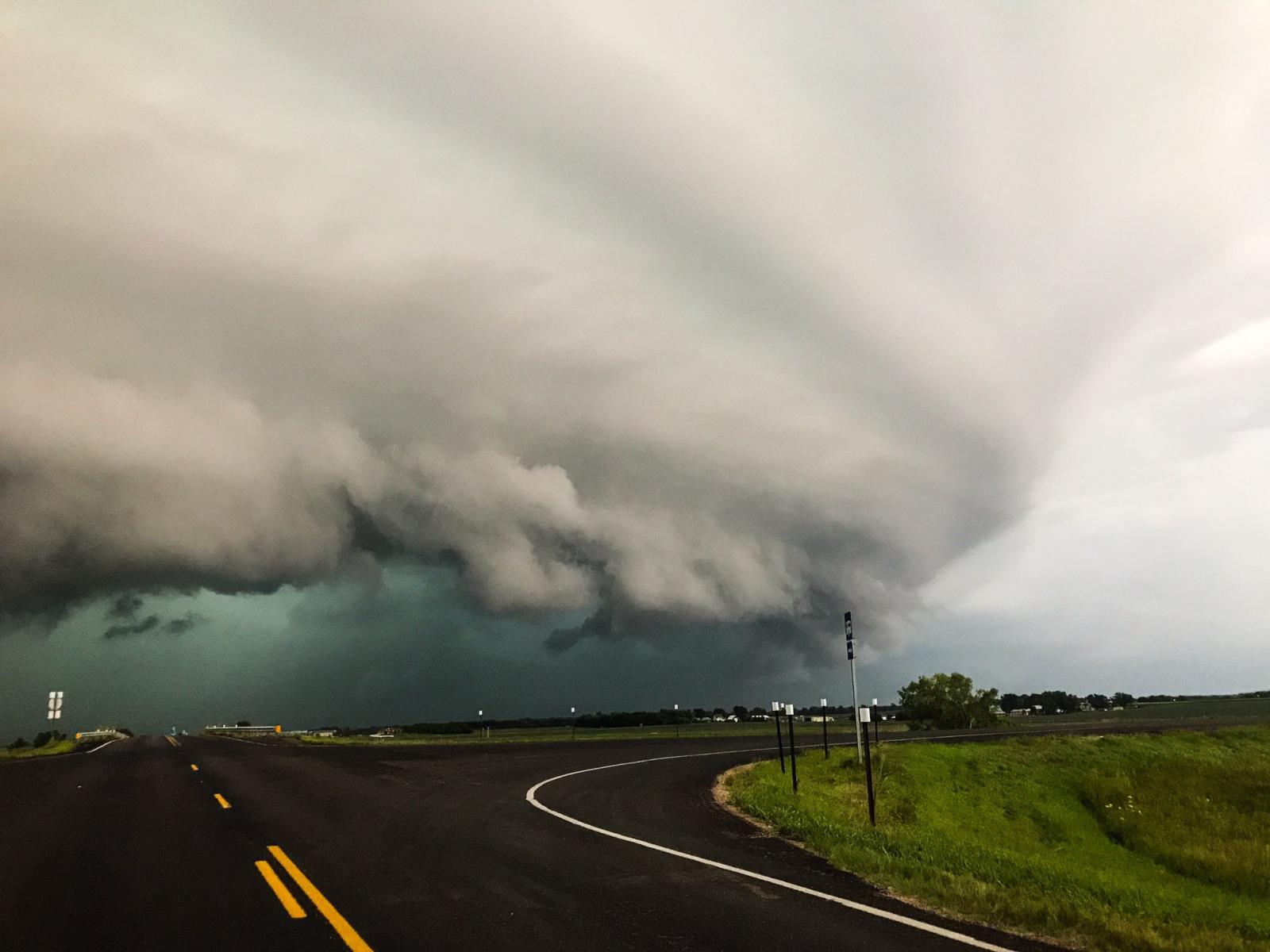
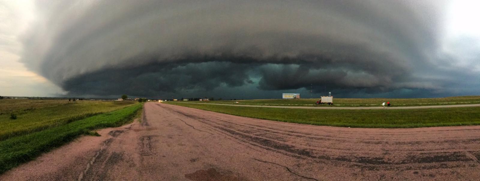
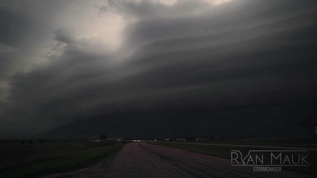
A line of strong to severe thunderstorms moved east across the region on the evening of Friday, August 25, 2017. The line produced isolated hail up to the size of ping pong balls, along with areas of damaging winds up to 60 mph. In addition to the severe weather, many areas received more than 1 inch of rainfall, with numerous reports in excess of 2 inches. |
 Loop of radar reflectivity between 6 pm and midnight Friday evening. |
Photos & Video:
Storm Photos
 |
 |
 |
| Storm west of Mitchell, SD (Ryan Mauk) |
Panoramic View of Storm Cloud (Ryan Mauk) |
(Ryan Mauk) |
Storm Reports
..TIME...   ...EVENT...      ...CITY LOCATION...     ...LAT.LON...
..DATE...   ....MAG....      ..COUNTY LOCATION..ST.. ...SOURCE....
            ..REMARKS..

0750 PM     TSTM WND GST     3 W MADISON             44.01N 97.17W
08/25/2017  E60 MPH          LAKE               SD   TRAINED SPOTTER


0750 PM     TSTM WND DMG     3 W MADISON             44.01N 97.17W
08/25/2017                   LAKE               SD   PUBLIC

            VENDOR TENTS, PORTA POTTIES, AND TRASH CANS
            BLOWN OVER AT PRAIRIE VILLAGE JAMBOREE. TIME
            ESTIMATED FROM RADAR.

0730 PM     TSTM WND GST     WINFRED                 44.00N 97.37W
08/25/2017  E60 MPH          LAKE               SD   TRAINED SPOTTER

            3 INCH TREE BRANCH DOWN AS WELL.

0720 PM     TSTM WND DMG     HOWARD                  44.01N 97.52W
08/25/2017                   MINER              SD   EMERGENCY MNGR

            NUMEROUS TREE LIMBS DOWN ACROSS TOWN.

0605 PM     TSTM WND GST     13 SSW PUKWANA          43.60N 99.27W
08/25/2017  E60 MPH          BRULE              SD   PUBLIC


0550 PM     HAIL             10 SSW PUKWANA          43.64N 99.27W
08/25/2017  E1.50 INCH       BRULE              SD   PUBLIC


0545 PM     HAIL             8 S CHAMBERLAIN         43.69N 99.31W
08/25/2017  E1.00 INCH       BRULE              SD   TRAINED SPOTTER


&&
Rain Reports
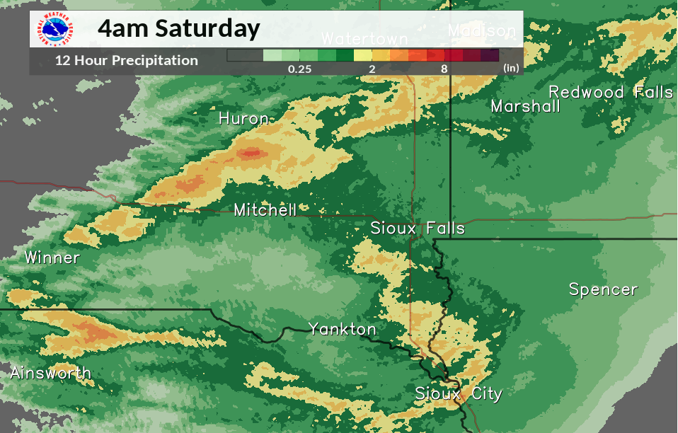
Here are some of the higher rainfall totals, with a complete list below the image:
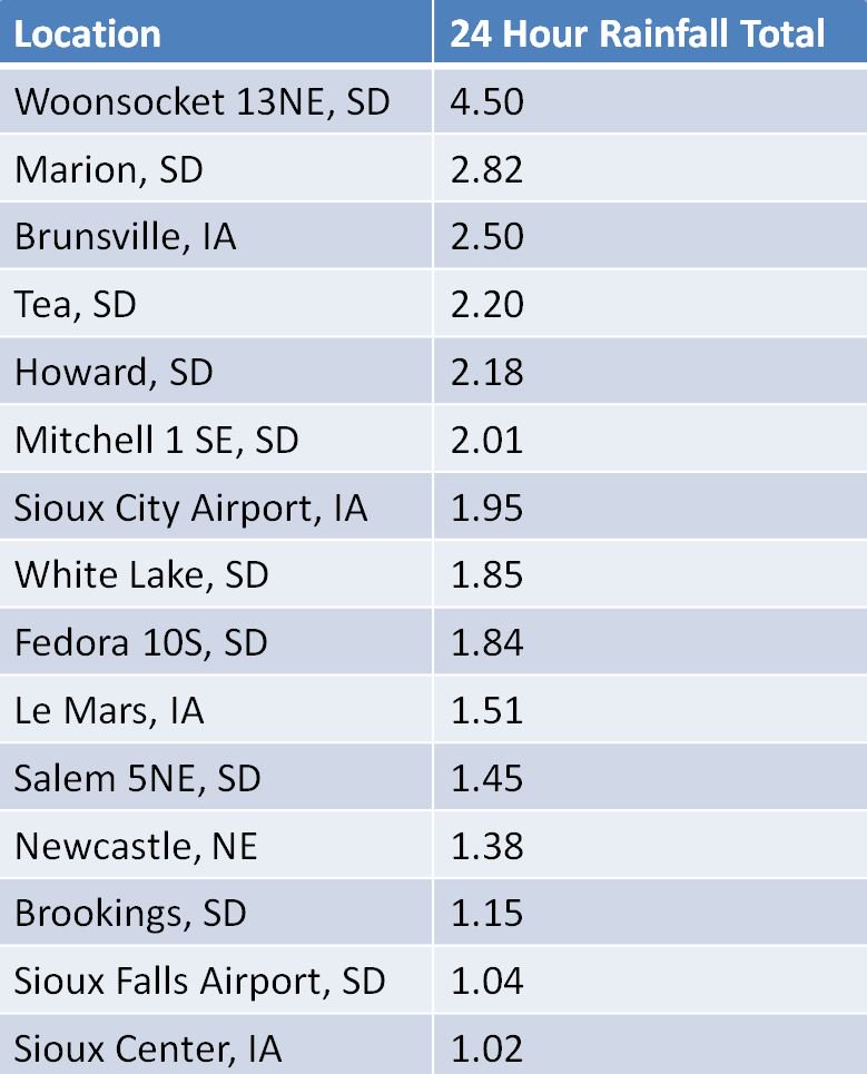
Public Information Statement
National Weather Service Sioux Falls SD
1204 PM CDT Sat Aug 26 2017

...24 Hour Rainfall Reports...

Location                     Amount    Time/Date       Lat/Lon
13 NE Woonsocket             4.50 in   0700 AM 08/26   44.09N/98.03W
9 SSW Wessington Springs     3.75 in   0600 AM 08/26   43.95N/98.62W
2 SW Hubbard                 3.36 in   0700 AM 08/26   42.35N/96.62W
Hubbard 0.1 NW               2.94 in   0700 AM 08/26   42.39N/96.59W
Bruce                        2.88 in   0700 AM 08/26   44.44N/96.89W
Marion                       2.82 in   0700 AM 08/26   43.42N/97.25W
Howard 5.3 W                 2.79 in   0700 AM 08/26   44.00N/97.63W
3 SSW Hinton                 2.48 in   1100 AM 08/26   42.58N/96.31W
4 ESE Bruce                  2.43 in   0700 AM 08/26   44.40N/96.81W
Hurley                       2.37 in   0600 AM 08/26   43.28N/97.09W
5 W Bruce                    2.23 in   0800 AM 08/26   44.43N/97.00W
2 NNW Sioux City             2.22 in   1100 AM 08/26   42.54N/96.41W
Howard                       2.18 in   0630 AM 08/26   44.02N/97.52W
2 W Worthing                 2.15 in   0700 AM 08/26   43.33N/96.80W
4 SSE Westfield              2.14 in   1111 AM 08/26   42.70N/96.58W
Hawarden                     2.10 in   0700 AM 08/26   43.00N/96.48W
1 SW Sioux City              2.09 in   1100 AM 08/26   42.49N/96.41W
4 SE Olivet                  2.08 in   1130 AM 08/26   43.19N/97.64W
2 W Westfield                2.01 in   0800 AM 08/26   42.76N/96.65W
Sioux City Ang               1.95 in   0600 AM 08/26   42.40N/96.38W
Sioux Gateway Airport        1.95 in   0652 AM 08/26   42.39N/96.38W
Winfred 2s                   1.94 in   0600 AM 08/26   43.97N/97.35W
Vermillion                   1.93 in   0800 AM 08/26   42.77N/96.92W
Plankinton 3.8 W             1.92 in   0700 AM 08/26   43.71N/98.56W
Alexandria 6.4 N             1.90 in   0700 AM 08/26   43.75N/97.79W
White Lake                   1.85 in   0700 AM 08/26   43.73N/98.72W
10 S Fedora                  1.84 in   0800 AM 08/26   43.86N/97.79W
9 NNE Fulton                 1.84 in   0800 AM 08/26   43.86N/97.79W
3 N Hawarden                 1.78 in   1116 AM 08/26   43.05N/96.49W
Akron                        1.76 in   1100 AM 08/26   42.84N/96.56W
3 E Kimball                  1.73 in   0800 AM 08/26   43.76N/98.88W
Aurora 7.5 N                 1.71 in   0800 AM 08/26   44.39N/96.69W
2 SE Vermillion              1.67 in   1120 AM 08/26   42.76N/96.92W
Remsen No. 2                 1.55 in   0900 AM 08/26   42.81N/95.98W
1 SW White                   1.55 in   0700 AM 08/26   44.41N/96.66W
Millnerville                 1.53 in   1045 AM 08/26   42.69N/96.37W
Le Mars Municipal Airport    1.51 in   0655 AM 08/26   42.78N/96.19W
Mitchell Municipal Airport   1.46 in   0653 AM 08/26   43.77N/98.04W
1 NNE Vermillion             1.45 in   0800 AM 08/26   42.81N/96.92W
4 S Sioux Falls              1.45 in   0700 AM 08/26   43.48N/96.73W
3 SW Sioux Falls             1.43 in   0700 AM 08/26   43.50N/96.79W
Sioux Falls 4.5 SSW          1.42 in   0600 AM 08/26   43.48N/96.76W
3 WSW Spencer                1.42 in   1045 AM 08/26   43.13N/95.21W
1 SW Sioux Falls             1.41 in   0700 AM 08/26   43.52N/96.75W
Hartford                     1.35 in   0600 AM 08/26   43.63N/96.94W
Mitchell 1.1 N               1.35 in   0700 AM 08/26   43.75N/98.03W
Hudson 8.3 WNW               1.34 in   0700 AM 08/26   43.17N/96.61W
3 SW Toronto                 1.34 in   0700 AM 08/26   44.53N/96.69W
2 NNW Le Mars                1.33 in   1135 AM 08/26   42.82N/96.19W
5 NW Montrose                1.31 in   0700 AM 08/26   43.77N/97.25W
Montrose 2.4 E               1.28 in   0700 AM 08/26   43.70N/97.14W
3 SSW Sioux Falls            1.28 in   1135 AM 08/26   43.49N/96.75W
2 SSW Crooks                 1.28 in   1115 AM 08/26   43.63N/96.83W
2 NNE Hartford               1.28 in   0700 AM 08/26   43.66N/96.92W
Lake Preston 10.5 NNE        1.25 in   0700 AM 08/26   44.50N/97.29W
2 NW Harrisburg              1.24 in   0700 AM 08/26   43.46N/96.73W
Russell                      1.23 in   1130 AM 08/26   44.32N/95.95W
3 NNE Parker                 1.20 in   1115 AM 08/26   43.45N/97.11W
De Smet                      1.19 in   0700 AM 08/26   44.38N/97.55W
Alton                        1.16 in   1100 AM 08/26   42.98N/96.00W
2 NE Brookings               1.15 in   0800 AM 08/26   44.32N/96.77W
3 WSW Brookings              1.15 in   0700 AM 08/26   44.28N/96.84W
Orange City Airport          1.14 in   0655 AM 08/26   42.99N/96.06W
Volga                        1.13 in   1140 AM 08/26   44.32N/96.92W
1 S Pukwana                  1.11 in   0700 AM 08/26   43.75N/99.18W
2 E Sioux Falls              1.11 in   0810 AM 08/26   43.54N/96.68W
Wessington Springs           1.10 in   0700 AM 08/26   44.08N/98.57W
3 ESE Sioux Falls            1.10 in   0700 AM 08/26   43.52N/96.67W
6 SSE Mitchell               1.10 in   0700 AM 08/26   43.64N/98.01W
Aurora                       1.08 in   0700 AM 08/26   44.29N/96.68W
2 N Vermillion               1.08 in   1130 AM 08/26   42.82N/96.92W
3 W Sioux Falls              1.07 in   0800 AM 08/26   43.53N/96.80W
Sioux Falls 3.4 WSW          1.07 in   0700 AM 08/26   43.52N/96.79W
Sioux Center                 1.07 in   1136 AM 08/26   43.06N/96.17W
5 SW Sioux Falls             1.07 in   0800 AM 08/26   43.53N/96.80W
1 NW Hartley                 1.06 in   1139 AM 08/26   43.20N/95.50W
5 ESE Crooks                 1.06 in   0700 AM 08/26   43.62N/96.72W
7 WNW Colton                 1.05 in   1131 AM 08/26   43.82N/97.07W
3 SSW Sioux Falls            1.04 in   1100 AM 08/26   43.50N/96.75W
Garretson 4.2 SSE            1.04 in   0700 AM 08/26   43.66N/96.47W
Sioux Falls Airport          1.04 in   0656 AM 08/26   43.58N/96.75W
Sioux Center                 1.03 in   1133 AM 08/26   43.08N/96.16W
2 W Arco                     1.02 in   1140 AM 08/26   44.39N/96.24W
1 WNW Baltic                 1.00 in   0700 AM 08/26   43.77N/96.77W
Brookings Municipal Airport  1.00 in   0656 AM 08/26   44.30N/96.82W
Sheldon                      0.99 in   0700 AM 08/26   43.18N/95.85W
Sioux Falls Harmondon Park   0.99 in   1130 AM 08/26   43.51N/96.65W
1 NE Sioux Falls             0.96 in   1130 AM 08/26   43.57N/96.71W
2 NNW Sioux Center           0.96 in   0700 AM 08/26   43.11N/96.18W
1 WSW Garretson              0.95 in   0700 AM 08/26   43.71N/96.53W
1 SW Brookings               0.95 in   0800 AM 08/26   44.29N/96.80W
Orange City                  0.94 in   0700 AM 08/26   43.00N/96.05W
5 E Ivanhoe                  0.94 in   0700 AM 08/26   44.46N/96.14W
2 SSW Brookings              0.89 in   0853 AM 08/26   44.27N/96.80W
Paullina                     0.89 in   0938 AM 08/26   42.98N/95.69W
1 NE Rowena                  0.88 in   0700 AM 08/26   43.54N/96.54W
2 ENE Hartford               0.87 in   1115 AM 08/26   43.64N/96.90W
1 NW Holly Springs           0.87 in   0700 AM 08/26   42.28N/96.10W
1 S Brookings                0.85 in   0700 AM 08/26   44.29N/96.79W
6 ESE Baltic                 0.83 in   1100 AM 08/26   43.73N/96.62W
Madison Airport              0.83 in   0650 AM 08/26   44.02N/97.09W
Clayton                      0.82 in   0600 AM 08/26   43.45N/97.66W
5 E Chester                  0.81 in   0700 AM 08/26   43.88N/96.81W
5 ESE Chester                0.80 in   1100 AM 08/26   43.85N/96.84W
Lester                       0.80 in   0700 AM 08/26   43.44N/96.33W
3 SE Mitchell                0.79 in   0745 AM 08/26   43.69N/98.00W
3 W Sioux Falls              0.78 in   1130 AM 08/26   43.53N/96.79W
3 WNW Everly                 0.77 in   0700 AM 08/26   43.18N/95.37W
Luverne                      0.74 in   1130 AM 08/26   43.65N/96.20W
2 E Madison                  0.74 in   0900 AM 08/26   44.00N/97.23W
5 N Mt Vernon                0.73 in   1115 AM 08/26   43.77N/98.25W
Marshall 0.6 S               0.73 in   0700 AM 08/26   44.44N/95.79W
4 N Cleghorn                 0.70 in   0700 AM 08/26   42.87N/95.72W
2N Chester                   0.70 in   0700 AM 08/26   43.93N/96.93W
Sheldon Airport              0.70 in   0655 AM 08/26   43.21N/95.84W
2 NE Academy                 0.68 in   0900 AM 08/26   43.49N/99.06W
Pipestone                    0.67 in   1130 AM 08/26   44.00N/96.31W
Flandreau                    0.65 in   1046 AM 08/26   44.06N/96.49W
2 ENE Ghent                  0.64 in   0700 AM 08/26   44.52N/95.84W
Pipestone Airport            0.64 in   0654 AM 08/26   43.98N/96.30W
Linn Grove                   0.63 in   1100 AM 08/26   42.90N/95.24W
Everly                       0.63 in   0700 AM 08/26   43.16N/95.33W
Pipestone                    0.63 in   1121 AM 08/26   44.01N/96.32W
Colman 10.6 N                0.62 in   0700 AM 08/26   44.14N/96.80W
Peterson                     0.60 in   0800 AM 08/26   42.93N/95.33W
Yankton Municipal Airport    0.60 in   0656 AM 08/26   42.92N/97.39W
1 W Gayville                 0.60 in   0700 AM 08/26   42.90N/97.21W
Oldham 0.9 E                 0.58 in   0700 AM 08/26   44.23N/97.29W
Worthington                  0.58 in   0700 AM 08/26   43.65N/95.58W
4 WSW Fostoria               0.58 in   1115 AM 08/26   43.21N/95.24W
Pipestone                    0.57 in   1130 AM 08/26   43.99N/96.43W
Worthington Muni Airport     0.56 in   0656 AM 08/26   43.65N/95.58W
3 NNE Rock Rapids            0.55 in   0700 AM 08/26   43.47N/96.16W
Marshall                     0.55 in   0800 AM 08/26   44.47N/95.80W
Hornick                      0.54 in   1100 AM 08/26   42.23N/96.08W
5 S Chamberlain              0.54 in   0700 AM 08/26   43.74N/99.31W
Edgerton                     0.54 in   0700 AM 08/26   43.88N/96.14W
Tracy Airport                0.53 in   0654 AM 08/26   44.25N/95.61W
Hitchcock 7.5 WSW            0.52 in   0700 AM 08/26   44.58N/98.54W
Luverne Municipal Airport    0.51 in   0658 AM 08/26   43.62N/96.22W
Sibley                       0.50 in   0700 AM 08/26   43.45N/95.71W
Holstein                     0.49 in   0700 AM 08/26   42.49N/95.53W
8 S Brookings                0.49 in   0730 AM 08/26   44.19N/96.79W
2 SE Burke                   0.47 in   0700 AM 08/26   43.16N/99.26W
Wall Lake                    0.46 in   1115 AM 08/26   43.53N/96.96W
5 SSW Stickney               0.44 in   0800 AM 08/26   43.51N/98.46W
3 SSE Lake Park              0.43 in   0700 AM 08/26   43.40N/95.31W
Spencer Municipal Airport    0.43 in   0653 AM 08/26   43.17N/95.21W
2 W Ethan                    0.42 in   0700 AM 08/26   43.55N/98.02W
Rock River Below Rock Rapids 0.41 in   1115 AM 08/26   43.42N/96.16W
4 SW Burke                   0.40 in   0700 AM 08/26   43.14N/99.35W
Lakefield                    0.38 in   0700 AM 08/26   43.68N/95.18W
Tyndall                      0.37 in   0800 AM 08/26   42.99N/97.86W
2 SE Yankton                 0.37 in   0630 AM 08/26   42.88N/97.36W
Minneota                     0.36 in   1131 AM 08/26   44.56N/95.99W
8 S Dallas                   0.36 in   0700 AM 08/26   43.11N/99.49W
7 E Heron Lake               0.35 in   0600 AM 08/26   43.79N/95.18W
Butte                        0.34 in   1129 AM 08/26   43.02N/98.90W
Windom Municipal Airport     0.31 in   0654 AM 08/26   43.91N/95.11W
1 SW Comfrey                 0.31 in   0900 AM 08/26   44.10N/94.93W
Tyler                        0.31 in   1137 AM 08/26   44.28N/96.13W
Lake Park                    0.30 in   0800 AM 08/26   43.45N/95.33W
Cherokee Municipal Airport   0.28 in   0655 AM 08/26   42.73N/95.55W
6 NNE Huron                  0.28 in   0700 AM 08/26   44.46N/98.17W
3 SSE Tabor                  0.27 in   0800 AM 08/26   42.90N/97.64W
3 SSW Arthur                 0.26 in   0843 AM 08/26   42.28N/95.36W
1 S Huron                    0.25 in   0830 AM 08/26   44.35N/98.22W
Jackson Municipal Airport    0.23 in   0654 AM 08/26   43.65N/94.99W
10 W Dimock                  0.19 in   0800 AM 08/26   43.50N/98.19W
Spirit Lake                  0.16 in   1115 AM 08/26   43.47N/95.12W
7 WSW Dimock                 0.14 in   0700 AM 08/26   43.44N/98.14W
7 WNW Naper                  0.14 in   0700 AM 08/26   43.00N/99.23W
4 E Gregory                  0.14 in   0700 AM 08/26   43.24N/99.34W
Herrick                      0.14 in   0700 AM 08/26   43.12N/99.19W
Huron Regional Airport       0.14 in   0655 AM 08/26   44.39N/98.23W
Bonesteel                    0.10 in   0800 AM 08/26   43.08N/98.95W

Observations are collected from a variety of sources with varying
equipment and exposures. We thank all volunteer weather observers
for their dedication. Not all data listed are considered official.
 |
Media use of NWS Web News Stories is encouraged! Please acknowledge the NWS as the source of any news information accessed from this site. |
|


 Weather Story
 Weather Map
 Local Radar