Overview
|
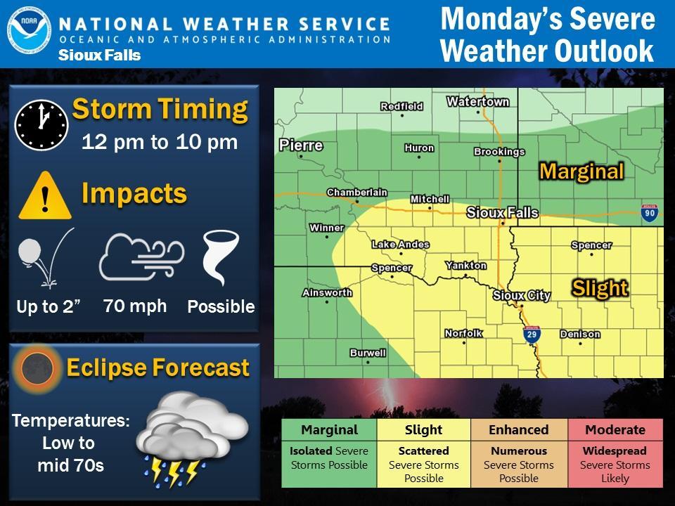
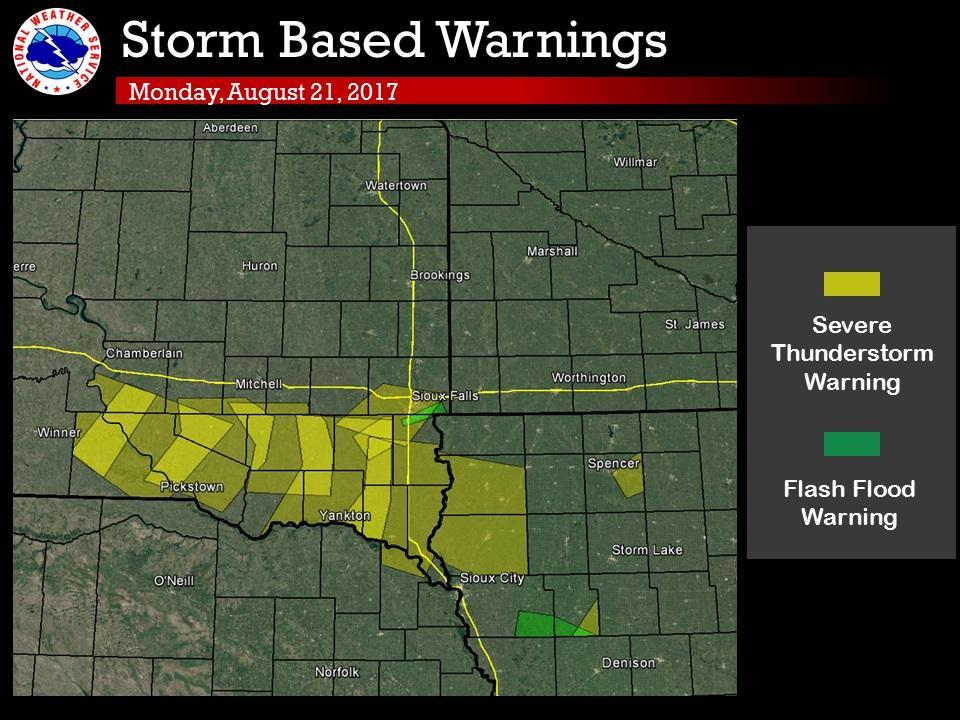
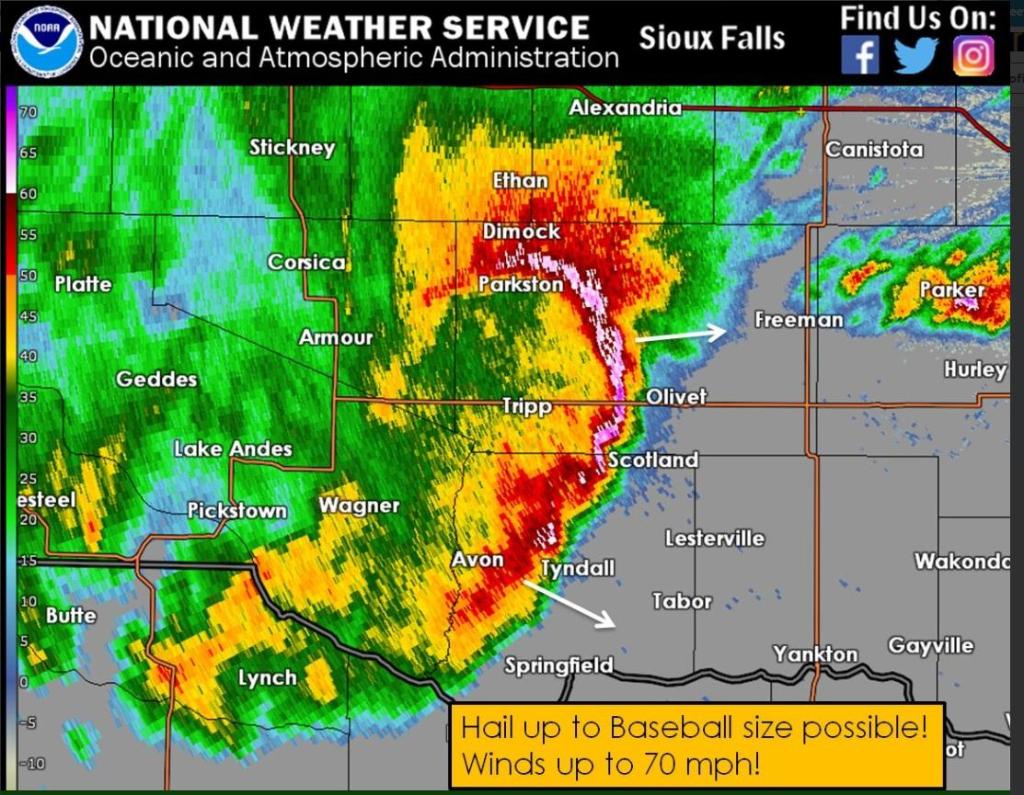
On Monday, August 21, 2017, during the solar eclipse, severe thunderstorms impacted the region producing: large hail, damaging winds, and locally heavy rain. Scattered thunderstorms began to develop early in the morning across central South Dakota, then became strong to severe as it approached the Missouri River Valley by mid to late morning. The biggest hail size of 2 inches (egg size) was reported at Olivet, SD in Hutchinson County.
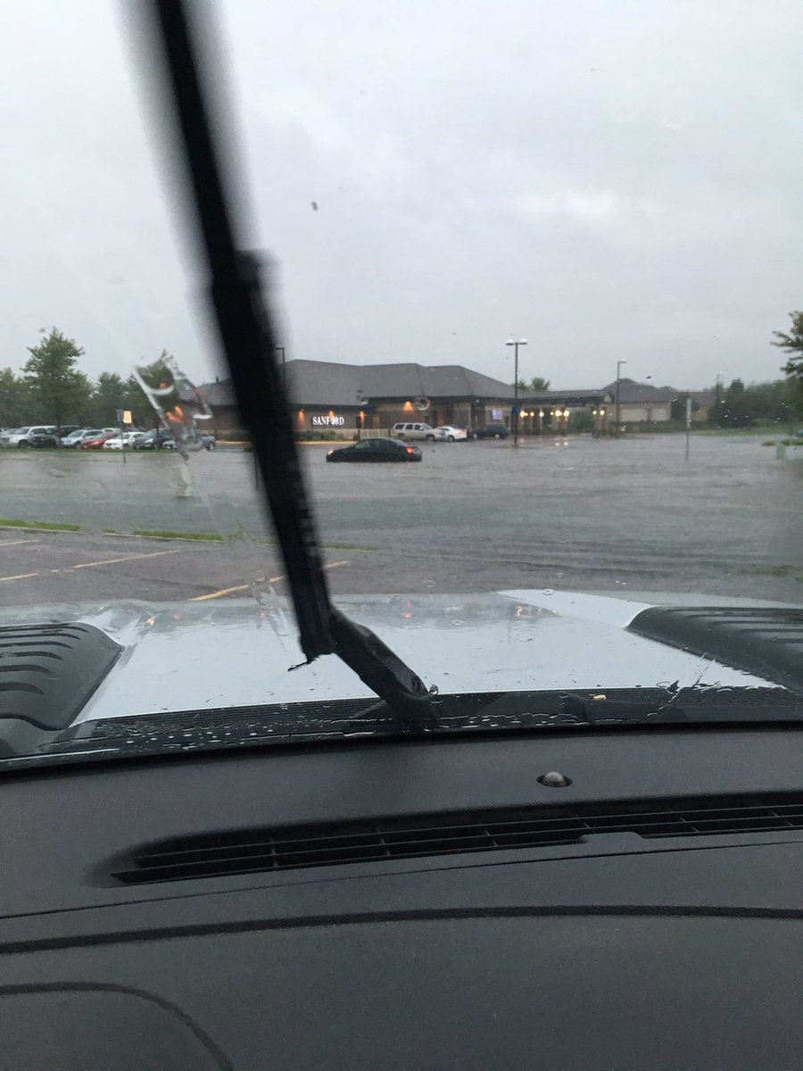
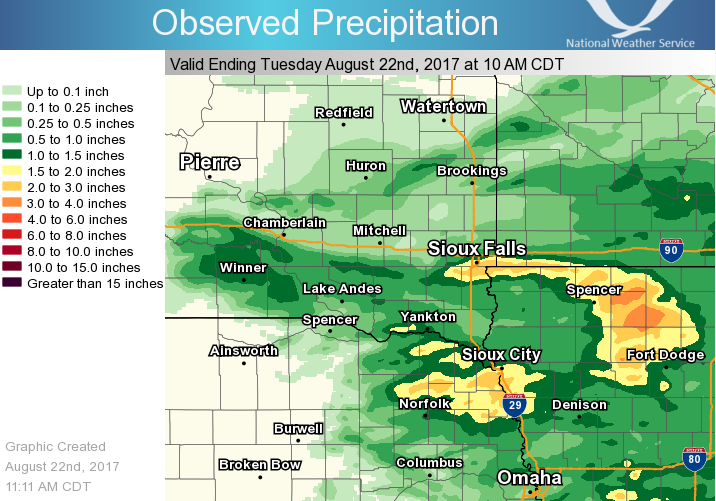
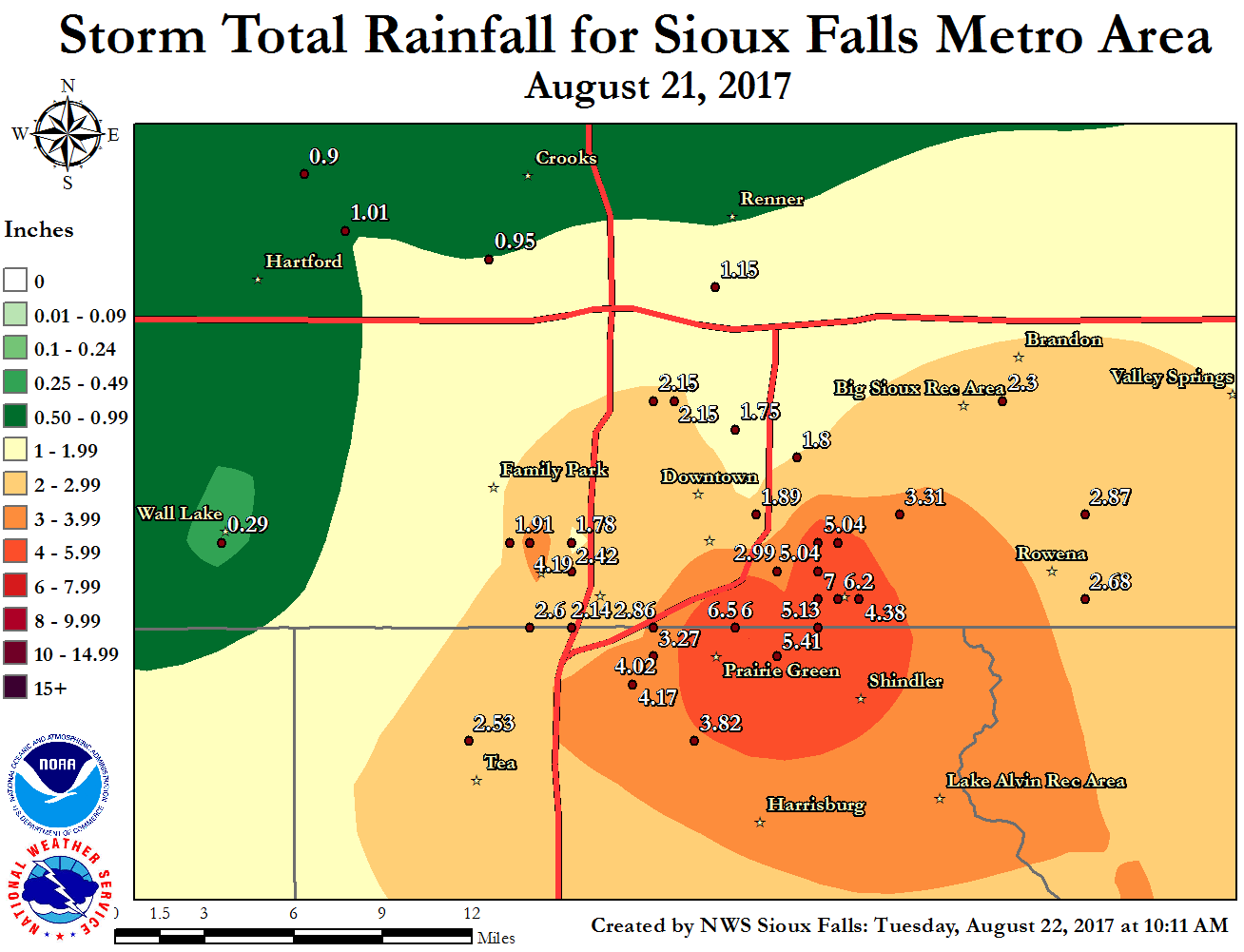
Ahead of this complex, a line of thunderstorms developed from near Parker, SD to Spencer, IA, along the I-90 corridor. These storms produced locally heavy rain, and flash flooding in some areas. The Sioux Falls Metro Area received from 2 to over 6 inches of rain early in the afternoon hours. The highest rainfall report was of 7 inches in southeastern Sioux Falls. |
|
 |
 |
|
Monday's Weather Story |
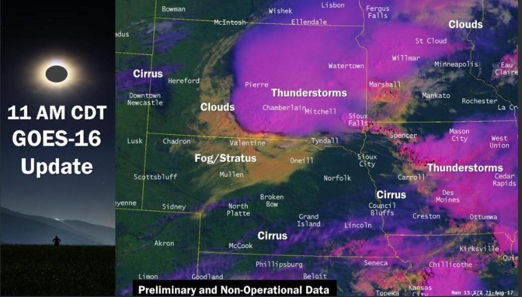
GOES-16 Visible Satellite Imagery at 11 am
|
Photos & Video:
Header
 |
 |
 |
 |
 |
|
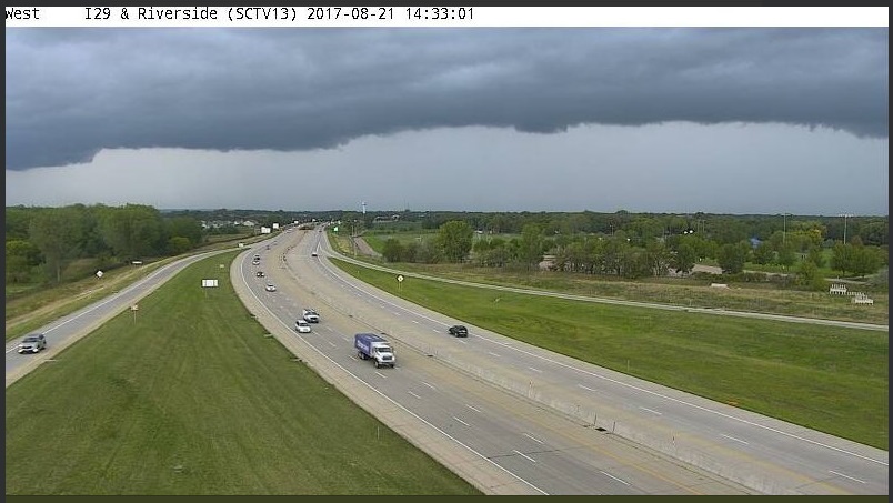
Shelf clouds moving towards Sioux City at 230 pm.
|
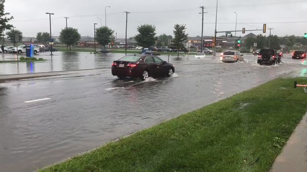
Street flooding in Sioux Falls (69th and Minnesota) |
Flash flooding in south-central Sioux Falls)
|
Storm based warnings issued.
|
GOES-16 Visible Image. A look at the solar eclipse as it crossed the United States. Cloudy skies prevailed across the Midwest during the eclipse. |
Radar:
Header
 |
 |
 |
|
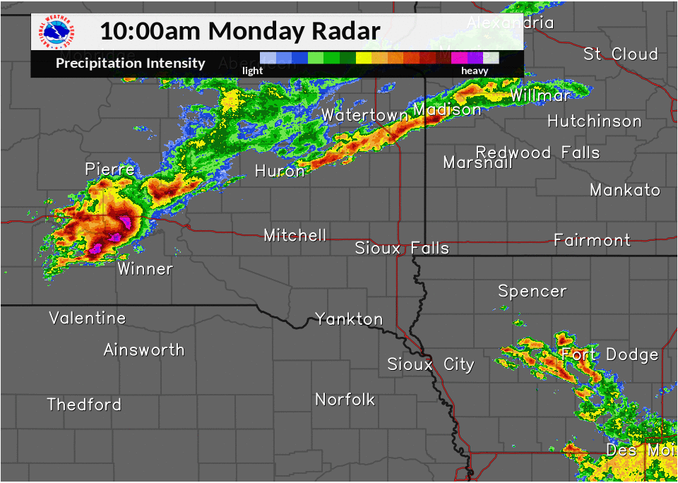
Radar Loop 10 am to 4 pm |
Long Range Radar Loop Storms began to develop over central South Dakota early in the morning. |
Severe thunderstorms that produced up to "egg" size hail.
|
Storm Reports
PRELIMINARY LOCAL STORM REPORT...SUMMARY
NATIONAL WEATHER SERVICE SIOUX FALLS SD
901 AM CDT TUE AUG 22 2017

..TIME...   ...EVENT...      ...CITY LOCATION...     ...LAT.LON...
..DATE...   ....MAG....      ..COUNTY LOCATION..ST.. ...SOURCE....
            ..REMARKS..

0500 PM     FLASH FLOOD      3 SSE SIOUX FALLS       43.51N 96.71W
08/21/2017                   MINNEHAHA          SD   NWS EMPLOYEE

            SPENCER PARK IN SIOUX FALLS IS FLOODED.

0500 PM     FLOOD            3 SSE SIOUX FALLS       43.51N 96.71W
08/21/2017                   MINNEHAHA          SD   NWS EMPLOYEE

            SPENCER PARK IN SIOUX FALLS IS FLOODED.

0245 PM     TSTM WND DMG     LE MARS                 42.79N 96.17W
08/21/2017                   PLYMOUTH           IA   LAW ENFORCEMENT

            TREE DAMAGE ON THE NORTHWEST SIDE OF TOWN.

0136 PM     HAIL             YANKTON                 42.89N 97.40W
08/21/2017  E1.00 INCH       YANKTON            SD   BROADCAST MEDIA

            ALONG WITH VERY HEAVY RAIN.

0106 PM     HAIL             4 SE MENNO              43.20N 97.52W
08/21/2017  E1.75 INCH       HUTCHINSON         SD   PUBLIC


1255 PM     HAIL             OLIVET                  43.24N 97.67W
08/21/2017  M2.00 INCH       HUTCHINSON         SD   EMERGENCY MNGR


1253 PM     HAIL             PARKER                  43.40N 97.14W
08/21/2017  E1.00 INCH       TURNER             SD   EMERGENCY MNGR


1225 PM     HAIL             CORSICA                 43.43N 98.41W
08/21/2017  E0.88 INCH       DOUGLAS            SD   PUBLIC


1210 PM     TSTM WND GST     CORSICA                 43.43N 98.40W
08/21/2017  E60 MPH          DOUGLAS            SD   PUBLIC


1205 PM     HAIL             7 NW HARRISON           43.50N 98.63W
08/21/2017  E1.75 INCH       AURORA             SD   PUBLIC


1157 AM     HAIL             1 E SIBLEY              43.40N 95.73W
08/21/2017  E0.88 INCH       OSCEOLA            IA   PUBLIC

            REPORTED BY EMERGENCY MANAGER.

1148 AM     HAIL             ROCK RAPIDS             43.43N 96.17W
08/21/2017  E1.00 INCH       LYON               IA   TRAINED SPOTTER


1106 AM     HAIL             MONROE                  43.49N 97.22W
08/21/2017  E0.88 INCH       TURNER             SD   TRAINED SPOTTER


1100 AM     HAIL             11 S CHAMBERLAIN        43.65N 99.32W
08/21/2017  E1.50 INCH       BRULE              SD   TRAINED SPOTTER


&&
Rain Reports
Header
 |
 |
 |
 |
|
Observed Precipitation
|
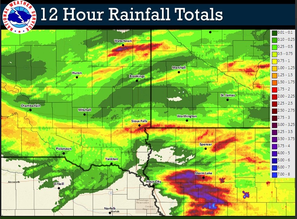
Storm Total Radar Estimate
|
Storm Total Rainfall for the Sioux Falls Area
|
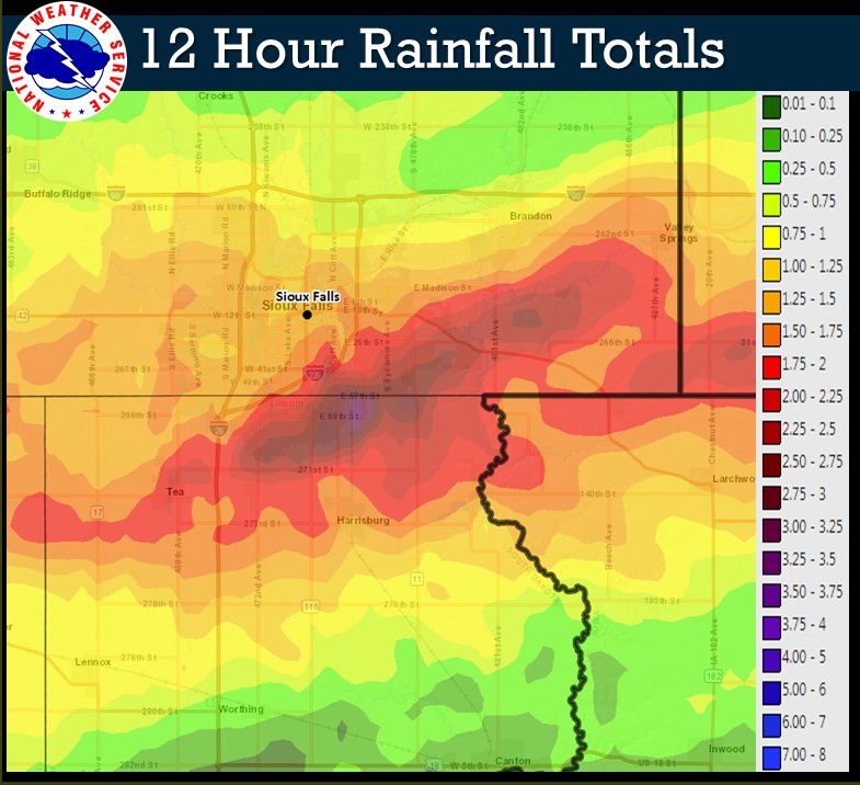
Storm Total Radar Estimate around the Sioux Falls Area
|
...Rainfall Reports From Monday's Rain Event...

Location                     Amount    Time/Date       Provider
4 SE Sioux Falls             7.00 in   0536 PM 08/21
3 SSE Sioux Falls            6.50 in   0603 PM 08/21
4 SE Sioux Falls             6.20 in   0544 PM 08/21
3 SSE Sioux Falls            6.00 in   0240 PM 08/21
4 SE Sioux Falls             5.73 in   0919 PM 08/21
4 N Harrisburg               5.41 in   0445 PM 08/21
4 SE Sioux Falls             5.13 in   0600 AM 08/22   COCORAHS
4 SE Sioux Falls             5.13 in   0600 AM 08/22
3 ESE Sioux Falls            5.04 in   0700 AM 08/22
Sioux Falls 3ese             5.04 in   0700 AM 08/22   UCOOP
3 ESE Sioux Falls            5.04 in   0700 AM 08/22   COCORAHS
3 ESE Sioux Falls            5.04 in   0700 AM 08/22
4 ESE Sioux Falls            4.43 in   0829 PM 08/21
5 ESE Sioux Falls            4.38 in   0330 PM 08/21
Sioux Falls Harmondon Park   4.38 in   0730 AM 08/22   UCOOP
5 ESE Sioux Falls            4.38 in   0730 AM 08/22
4 WSW Sioux Falls            4.19 in   1029 PM 08/21
4 ENE Tea                    4.17 in   0427 PM 08/21
Sioux Falls 4.5 SSW          4.02 in   0600 AM 08/22   COCORAHS
4 ENE Tea                    4.02 in   0600 AM 08/22
2 NW Harrisburg              3.82 in   0600 AM 08/22   COCORAHS
3 NW Harrisburg              3.82 in   0600 AM 08/22
3 ESE Sioux Falls            3.72 in   0354 PM 08/21
4 WNW Rowena                 3.31 in   0400 PM 08/21
4 SSW Sioux Falls            3.27 in   0405 PM 08/21
3 SSW Sioux Falls            3.27 in   0745 AM 08/22   CWOP
6 SW Larchwood               3.10 in   0911 PM 08/21
Vicks Corner-spirit Lake Iow 3.00 in   1200 AM 08/22   UCOOP
3 NW Okoboji                 3.00 in   1200 AM 08/22
3 SE Sioux Falls             2.99 in   1027 PM 08/21
4 S Adrian                   2.92 in   1038 PM 08/21
1 NE Rowena                  2.87 in   0500 AM 08/22   COCORAHS
2 NNE Rowena                 2.87 in   0500 AM 08/22
3 SSW Sioux Falls            2.86 in   0300 PM 08/21
3 SSW Sioux Falls            2.86 in   0700 AM 08/22   HADS
1 SE Rowena                  2.68 in   0315 PM 08/21
4 NNE Tea                    2.60 in   0727 PM 08/21
1 N Tea                      2.53 in   0700 AM 08/22
1 NNW Tea                    2.53 in   0700 AM 08/22   COCORAHS
Sioux Falls 3.4 WSW          2.42 in   0651 AM 08/22   COCORAHS
3 WSW Sioux Falls            2.42 in   0651 AM 08/22
1 S Brandon                  2.30 in   0747 PM 08/21
3 SSW Hubbard                2.20 in   0700 AM 08/22
2 SW Hubbard                 2.20 in   0700 AM 08/22   COCORAHS
3 NNW Sioux Falls            2.15 in   0656 AM 08/22
3 NNW Sioux Falls            2.15 in   0530 PM 08/21
Sioux Falls Airport          2.15 in   0656 AM 08/22   ASOS
3 SW Sioux Falls             2.14 in   0700 AM 08/22   COCORAHS
Spirit Lake                  2.02 in   0715 AM 08/22   GOES
Sibley                       1.93 in   0700 AM 08/22   COOP
4 NNE Sibley                 1.93 in   0700 AM 08/22
4 W Sioux Falls              1.91 in   0753 AM 08/22   CWOP
2 E Sioux Falls              1.89 in   0459 PM 08/21
3 ENE Sioux Falls            1.80 in   0700 AM 08/22
Sioux Falls Oak View Library 1.80 in   0700 AM 08/22   UCOOP
3 SSE Lake Park              1.80 in   0215 AM 08/22   CWOP
3 W Sioux Falls              1.78 in   0730 AM 08/22   HADS
3 NNE Parker                 1.76 in   0715 AM 08/22   HADS
1 NE Sioux Falls             1.75 in   0730 AM 08/22   USARMY-COE
5 S Marion                   1.70 in   0700 AM 08/22
4 S Marion                   1.70 in   0700 AM 08/22   COCORAHS
3 NE Cherokee                1.67 in   0820 PM 08/21
1 NW Hartley                 1.62 in   0751 AM 08/22   CWOP
3 N Hawarden                 1.56 in   0730 AM 08/22   HADS
Spencer Municipal Airport    1.49 in   0653 AM 08/22   ASOS
3 WNW Spencer                1.49 in   0653 AM 08/22
Sioux Gateway Airport        1.47 in   0652 AM 08/22   ASOS
Platte                       1.47 in   0753 AM 08/22   CWOP
1 WSW Sergeant Bluff         1.47 in   0652 AM 08/22
1 W Sergeant Bluff           1.40 in   0600 AM 08/22
Sioux Center                 1.40 in   0742 AM 08/22   CWOP
Sioux City Ang               1.40 in   0600 AM 08/22   COOP
Gregory 8.7 N                1.35 in   0700 AM 08/22   COCORAHS
3 ESE Dixon                  1.35 in   0700 AM 08/22
3 WSW Spencer                1.35 in   0745 AM 08/22   HADS
Emerson                      1.30 in   0700 AM 08/22
Emerson                      1.30 in   0700 AM 08/22   COOP
Linn Grove                   1.29 in   0700 AM 08/22   HADS
1 NW Canton                  1.27 in   0600 AM 08/22
Canton                       1.27 in   0600 AM 08/22   COOP
2 SSW Luverne                1.25 in   0659 AM 08/22
Luverne Airport              1.25 in   0659 AM 08/22   AWOS
Paullina                     1.24 in   0700 AM 08/22   COCORAHS
Paullina                     1.24 in   0700 AM 08/22
4 WSW Fostoria               1.20 in   0715 AM 08/22   HADS
3 WNW Everly                 1.18 in   0700 AM 08/22
3 WNW Everly                 1.18 in   0700 AM 08/22   COOP
Sheldon                      1.16 in   0700 AM 08/22   COOP
Sheldon                      1.16 in   0700 AM 08/22
Everly                       1.15 in   0700 AM 08/22
Everly                       1.15 in   0700 AM 08/22   COCORAHS
5 ESE Crooks                 1.15 in   0700 AM 08/22   COCORAHS
5 ESE Crooks                 1.15 in   0700 AM 08/22
Hurley                       1.12 in   0600 AM 08/22   COCORAHS
Hurley                       1.12 in   0600 AM 08/22
1 SW Sioux City              1.11 in   0700 AM 08/22   HADS
2 N Yankton                  1.09 in   0656 AM 08/22
Yankton Municipal Airport    1.09 in   0656 AM 08/22   AWOS
2 NNE Worthington            1.05 in   0700 AM 08/22
Worthington                  1.05 in   0700 AM 08/22   COOP
Marshall                     1.05 in   0810 PM 08/21
2 NNW Le Mars                1.04 in   0751 AM 08/22   CWOP
2 ENE Hartford               1.01 in   0717 AM 08/22   HADS
Worthington Airport          1.01 in   0656 AM 08/22   AWOS
2 NNE Worthington            1.01 in   0656 AM 08/22
Sioux Center                 1.00 in   0748 AM 08/22   CWOP
Clayton                      1.00 in   0600 AM 08/22   COCORAHS
Holly Springs 1nw            1.00 in   0700 AM 08/22   COOP
Clayton                      1.00 in   0600 AM 08/22
Luverne                      1.00 in   0730 AM 08/22   HADS
4 SE Olivet                  0.99 in   0800 AM 08/22   HADS
2 W Westfield                0.99 in   0800 AM 08/22   COCORAHS
2 SSW Crooks                 0.95 in   0731 AM 08/22   HADS
Marshall                     0.95 in   0745 AM 08/22   GOES
5 NNW Tripp                  0.93 in   0700 AM 08/22
5 NNW Tripp                  0.93 in   0700 AM 08/22   COCORAHS
7 WSW Platte                 0.93 in   0715 AM 08/22   HADS
4 N Cleghorn                 0.91 in   0700 AM 08/22   COCORAHS
5 E Ivanhoe                  0.91 in   0700 AM 08/22
5 E Ivanhoe                  0.91 in   0700 AM 08/22   COCORAHS
3 NNE Hartford               0.90 in   0700 AM 08/22
2 NNE Hartford               0.90 in   0700 AM 08/22   COCORAHS
4 SSE Westfield              0.84 in   0711 AM 08/22   RAWS
4 SW Burke                   0.84 in   0700 AM 08/22   COCORAHS
Lake Andes RAWS              0.71 in   0741 AM 08/22   RAWS
Millnerville                 0.69 in   0645 AM 08/22   UCOOP
6 NW Hinton                  0.69 in   0645 AM 08/22
2 S Orange City              0.68 in   0700 AM 08/22   COCORAHS
2 S Orange City              0.68 in   0700 AM 08/22
Sheldon Airport              0.67 in   0655 AM 08/22   AWOS
2 N Sheldon                  0.67 in   0655 AM 08/22
Remsen No. 2                 0.67 in   0630 AM 08/22   COOP
Remsen                       0.67 in   0630 AM 08/22
Lakefield                    0.66 in   0700 AM 08/22
Alta                         0.66 in   0700 AM 08/22
Lakefield                    0.66 in   0700 AM 08/22   COOP
Alta                         0.66 in   0700 AM 08/22   COCORAHS
4 S Arthur                   0.63 in   0613 AM 08/22
3 SSW Arthur                 0.63 in   0613 AM 08/22   COCORAHS
Akron                        0.60 in   0700 AM 08/22   HADS
1 NNE Tracy                  0.59 in   0653 AM 08/22
Herrick                      0.59 in   0700 AM 08/22   COCORAHS
9 S Dallas                   0.59 in   0700 AM 08/22
8 S Dallas                   0.59 in   0700 AM 08/22   COCORAHS
Tracy Airport                0.59 in   0653 AM 08/22   AWOS
Herrick                      0.59 in   0700 AM 08/22
3 N Windom                   0.58 in   0654 AM 08/22
Windom Muni Airport          0.58 in   0654 AM 08/22   AWOS
Alton                        0.57 in   0700 AM 08/22   HADS
Hornick                      0.55 in   0700 AM 08/22   HADS
2 N Vermillion               0.55 in   0730 AM 08/22   HADS
3 SSW Hinton                 0.54 in   0700 AM 08/22   USARMY-COE
Butte                        0.54 in   0750 AM 08/22   CWOP
2 N Jackson                  0.52 in   0654 AM 08/22
Jackson Airport              0.52 in   0654 AM 08/22   AWOS
De Smet                      0.50 in   0700 AM 08/22
De Smet                      0.50 in   0700 AM 08/22   COCORAHS
1 WSW Garretson              0.50 in   0635 AM 08/22   COCORAHS
2 WSW Garretson              0.50 in   0635 AM 08/22
2 W Arco                     0.47 in   0800 AM 08/22   CWOP
De Smet                      0.47 in   0811 PM 08/21
Huron-33mi.e                 0.47 in   0811 PM 08/21   COOP
1 S Orange City              0.46 in   0655 AM 08/22
Rock River Below Rock Rapids 0.46 in   0715 AM 08/22   UCOOP
Russell                      0.46 in   0730 AM 08/22   GOES
Orange City Airport          0.46 in   0655 AM 08/22   AWOS
1 SE Rock Rapids             0.46 in   0715 AM 08/22
1 S Huron                    0.43 in   0700 AM 08/22   COCORAHS
1 S Huron                    0.43 in   0700 AM 08/22
3 SSE Wilder                 0.41 in   0600 AM 08/22
7 E Heron Lake               0.41 in   0600 AM 08/22   UCOOP
Bridgewater                  0.40 in   0800 AM 08/22   COOP
Spirit Lake                  0.35 in   0756 AM 08/22   CWOP
5 S Chamberlain              0.34 in   0700 AM 08/22
5 S Chamberlain              0.34 in   0700 AM 08/22   COOP
Brookings                    0.33 in   0800 AM 08/22   COCORAHS
3 N Sioux City               0.32 in   0803 AM 08/22   CWOP
2 W Ethan                    0.31 in   0700 AM 08/22   COCORAHS
2 W Ethan                    0.31 in   0700 AM 08/22
7 WNW Naper                  0.30 in   0700 AM 08/22   COCORAHS
8 SSW Herrick                0.30 in   0700 AM 08/22
Wall Lake                    0.29 in   0715 AM 08/22   HADS
6 ESE Baltic                 0.29 in   0700 AM 08/22   GOES
Wessington Springs           0.28 in   0700 AM 08/22
Wessington Springs           0.28 in   0700 AM 08/22   COOP
1 NW Edgerton                0.27 in   0700 AM 08/22
Edgerton                     0.27 in   0700 AM 08/22   COCORAHS
Storden                      0.25 in   0758 AM 08/22   CWOP
1 SW Brookings               0.22 in   0800 AM 08/22   COCORAHS
Sioux Falls 14 NNE           0.21 in   0700 AM 08/22   GOES
2 WSW Brookings              0.19 in   0656 AM 08/22
2 SE Astoria                 0.19 in   0700 AM 08/22   COCORAHS
Brookings Municipal Airport  0.19 in   0656 AM 08/22   AWOS
3 SW Toronto                 0.18 in   0700 AM 08/22   COCORAHS
7 NNW White                  0.18 in   0700 AM 08/22
2 NE Brookings               0.18 in   0800 AM 08/22   COOP
Tyler                        0.17 in   0758 AM 08/22   CWOP
2 NNW Huron                  0.14 in   0655 AM 08/22
Huron Regional Airport       0.14 in   0655 AM 08/22   ASOS
Slayton Municipal Airport    0.14 in   0651 AM 08/22   AWOS
1 E Slayton                  0.14 in   0651 AM 08/22
8 S Brookings                0.13 in   0730 AM 08/22
8 S Brookings                0.13 in   0730 AM 08/22   COCORAHS
2 SSE Pipestone              0.12 in   0654 AM 08/22
Pipestone Airport            0.12 in   0654 AM 08/22   AWOS
2 N Chester                  0.11 in   0700 AM 08/22
Chester 2n                   0.11 in   0700 AM 08/22   COOP
White Lake                   0.10 in   0700 AM 08/22
Pipestone                    0.10 in   0721 AM 08/22   RAWS
Pipestone                    0.10 in   0730 AM 08/22   HADS
1 S Pukwana                  0.10 in   0700 AM 08/22   COCORAHS
2 S Pukwana                  0.10 in   0700 AM 08/22
White Lake                   0.10 in   0700 AM 08/22   COOP
5 ESE Chester                0.09 in   0700 AM 08/22   HADS
6 SSE Mitchell               0.09 in   0700 AM 08/22   COCORAHS
6 W Pipestone                0.09 in   0730 AM 08/22
7 S Mitchell                 0.09 in   0700 AM 08/22
Pipestone                    0.09 in   0730 AM 08/22   UCOOP
5 N Brookings                0.09 in   0700 AM 08/22   COCORAHS
7 WNW Colton                 0.08 in   0730 AM 08/22   HADS
Volga                        0.08 in   0758 AM 08/22   CWOP
Mitchell                     0.07 in   1200 AM 08/22   COOP
2 S Mitchell                 0.07 in   1200 AM 08/22
3 N Mitchell                 0.06 in   0653 AM 08/22
Oldham 0.9 E                 0.06 in   0700 AM 08/22   COCORAHS
1 E Oldham                   0.06 in   0700 AM 08/22
Mitchell Municipal Airport   0.06 in   0653 AM 08/22   ASOS
Flandreau                    0.06 in   0731 AM 08/22   UCOOP
5 E Flandreau                0.06 in   0731 AM 08/22
Alexandria                   0.05 in   0700 AM 08/22   COOP
James River                  0.05 in   0715 AM 08/22   COOP
1 WNW Chamberlain            0.05 in   0530 AM 08/22
Chamberlain                  0.05 in   0530 AM 08/22   COCORAHS
Alexandria                   0.05 in   0700 AM 08/22
4 SSE Forestburg             0.05 in   0715 AM 08/22
2 ENE Jefferson              0.04 in   0730 AM 08/22   HADS
2 WNW Mitchell               0.04 in   0700 AM 08/22   COCORAHS
2 WNW Mitchell               0.04 in   0700 AM 08/22
5 SSW Jasper                 0.02 in   0715 AM 08/22
Jasper                       0.02 in   0715 AM 08/22   UCOOP
Madison Airport              0.01 in   0650 AM 08/22   AWOS
1 NE Madison                 0.01 in   0650 AM 08/22
Hiway 77 Bridge              0.01 in   0730 AM 08/22   COOP
5 WNW Sioux City             0.01 in   0730 AM 08/22

Observations are collected from a variety of sources with varying
equipment and exposures. We thank all volunteer weather observers
for their dedication. Not all data listed are considered official. ++
 |
Media use of NWS Web News Stories is encouraged! Please acknowledge the NWS as the source of any news information accessed from this site. |
|


 Weather Story
 Weather Map
 Local Radar