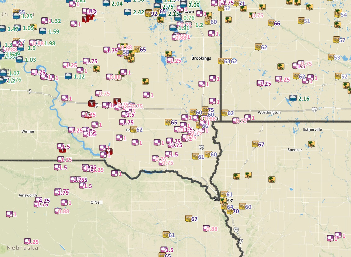
| Report Time |
County |
Location |
ST |
Event Type |
Mag. |
Source |
Remark |
| Tue Jun 13 2017 20:40:00 GMT-0500 (Central Daylight Time) |
Gregory |
4 SE Burke |
SD |
TORNADO |
0 |
fire dept/rescue |
|
| Tue Jun 13 2017 20:45:00 GMT-0500 (Central Daylight Time) |
Gregory |
Burke |
SD |
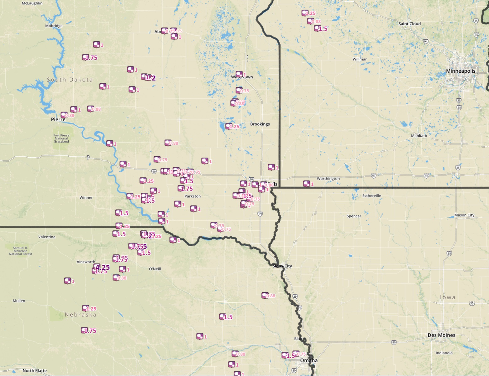
HAIL |
1.5 |
fire dept/rescue |
|
| Tue Jun 13 2017 21:11:00 GMT-0500 (Central Daylight Time) |
Charles Mix |
13 W Platte |
SD |
HAIL |
1.25 |
public |
|
| Tue Jun 13 2017 21:35:00 GMT-0500 (Central Daylight Time) |
Gregory |
9 SSW Herrick |
SD |
HAIL |
1.25 |
public |
|
| Tue Jun 13 2017 21:43:00 GMT-0500 (Central Daylight Time) |
Brule |
2 NW Pukwana |
SD |
HAIL |
1 |
public |
|
| Tue Jun 13 2017 21:45:00 GMT-0500 (Central Daylight Time) |
Brule |
12 SSE Kimball |
SD |
HAIL |
1.25 |
public |
|
| Tue Jun 13 2017 21:53:00 GMT-0500 (Central Daylight Time) |
Brule |
11 SSW White Lake |
SD |
TORNADO |
0 |
law enforcement |
|
| Tue Jun 13 2017 22:07:00 GMT-0500 (Central Daylight Time) |
Aurora |
1 WNW White Lake |
SD |
TORNADO |
0 |
fire dept/rescue |
|
| Tue Jun 13 2017 22:19:00 GMT-0500 (Central Daylight Time) |
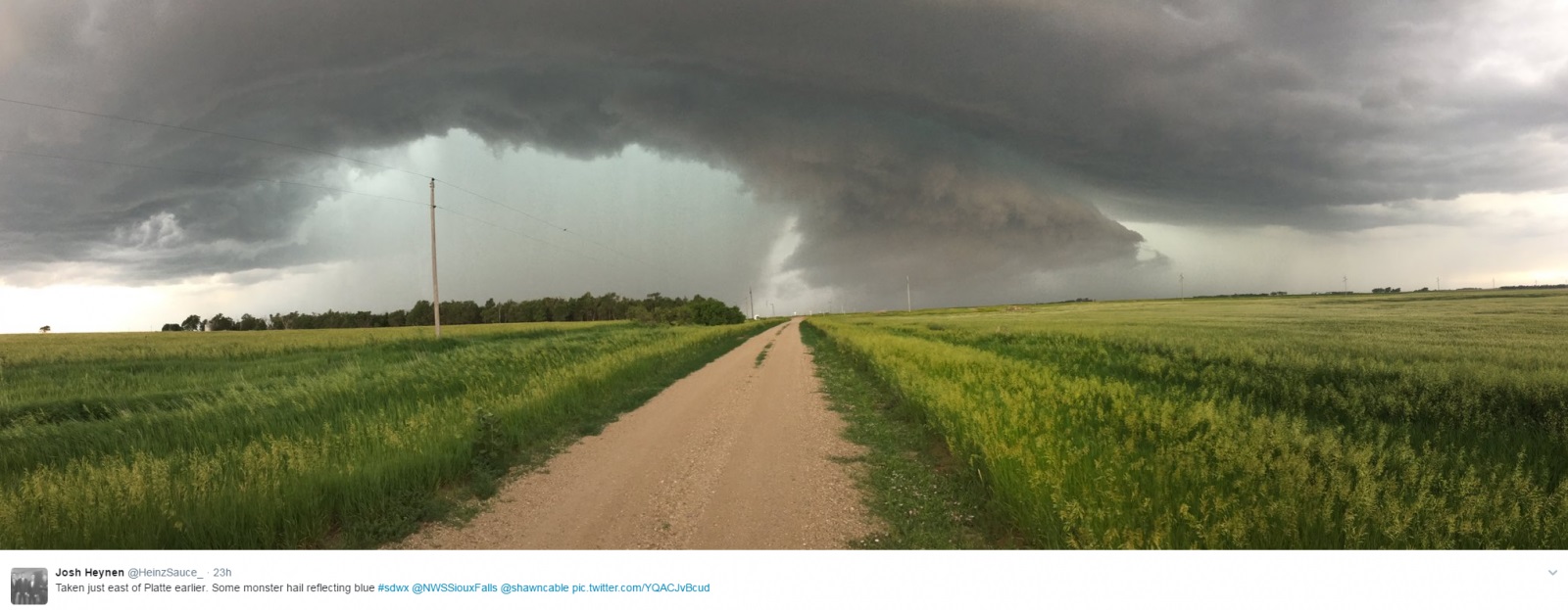
Charles Mix |
Platte |
SD |
HAIL |
1.5 |
law enforcement |
|
| Tue Jun 13 2017 22:20:00 GMT-0500 (Central Daylight Time) |
Aurora |
11 NNE White Lake |
SD |
HAIL |
0.75 |
trained spotter |
|
| Tue Jun 13 2017 22:26:00 GMT-0500 (Central Daylight Time) |
Charles Mix |
4 ESE Platte |
SD |
HAIL |
1 |
trained spotter |
|
| Tue Jun 13 2017 22:31:00 GMT-0500 (Central Daylight Time) |
Douglas |
7 W Harrison |
SD |
HAIL |
1 |
trained spotter |
|
| Tue Jun 13 2017 22:40:00 GMT-0500 (Central Daylight Time) |
Jerauld |
Lane |
SD |
HAIL |
0.88 |
trained spotter |
wind of 50-55 mph. |
| Tue Jun 13 2017 22:45:00 GMT-0500 (Central Daylight Time) |
Charles Mix |
3 SSE Platte |
SD |
HAIL |
1.5 |
public |
|
| Tue Jun 13 2017 22:52:00 GMT-0500 (Central Daylight Time) |
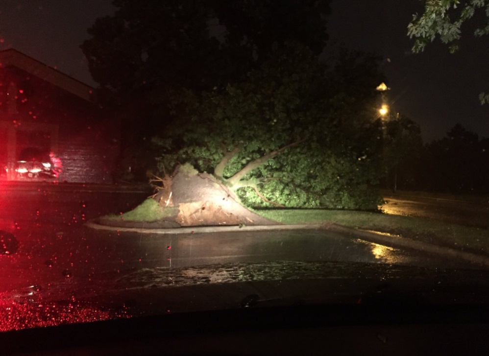
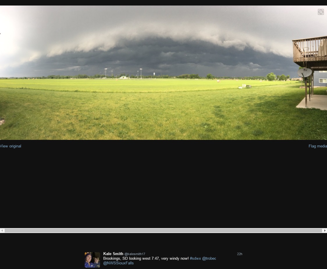
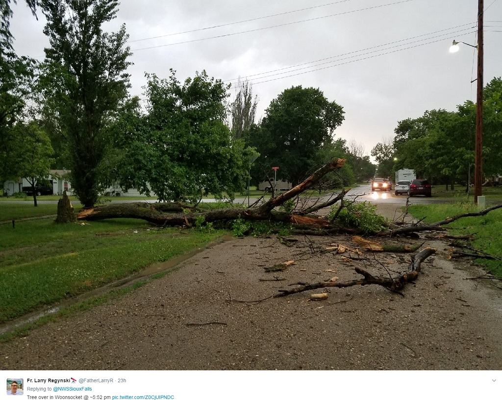
Sanborn |
Woonsocket |
SD |
TSTM WND DMG |
0 |
public |
tree down. (report via social media). |
| Tue Jun 13 2017 22:56:00 GMT-0500 (Central Daylight Time) |
Charles Mix |
Pickstown |
SD |
HAIL |
1 |
trained spotter |
|
| Tue Jun 13 2017 22:57:00 GMT-0500 (Central Daylight Time) |
Aurora |
1 SSW Plankinton |
SD |
HAIL |
1 |
emergency mngr |
|
| Tue Jun 13 2017 22:59:00 GMT-0500 (Central Daylight Time) |
Aurora |
2 ESE Plankinton |
SD |
HAIL |
1 |
public |
also 50 to 60 mph winds. |
| Tue Jun 13 2017 23:02:00 GMT-0500 (Central Daylight Time) |
Charles Mix |
2 S Ravinia |
SD |
TORNADO |
0 |
storm chaser |
tornado on the ground from 4 sse ravina to wagner from 602 -605 pm. |
| Tue Jun 13 2017 23:06:00 GMT-0500 (Central Daylight Time) |
Davison |
1 WNW Mount Vernon |
SD |
HAIL |
0.75 |
law enforcement |
|
| Tue Jun 13 2017 23:07:00 GMT-0500 (Central Daylight Time) |
Charles Mix |
Lake Andes |
SD |
HAIL |
1 |
law enforcement |
|
| Tue Jun 13 2017 23:13:00 GMT-0500 (Central Daylight Time) |
Davison |
4 NNW Mount Vernon |
SD |
TORNADO |
0 |
trained spotter |
very brief touchdown. |
| Tue Jun 13 2017 23:18:00 GMT-0500 (Central Daylight Time) |
Beadle |
7 NNE Huron |
SD |
TSTM WND DMG |
0 |
public |
blew off previously damaged barn roof. time estimated from radar. |
| Tue Jun 13 2017 23:20:00 GMT-0500 (Central Daylight Time) |
Beadle |
6 S Cavour |
SD |
TSTM WND DMG |
0 |
public |
power lines downed. |
| Tue Jun 13 2017 23:20:00 GMT-0500 (Central Daylight Time) |
Beadle |
Cavour |
SD |
TSTM WND DMG |
0 |
public |
multiple trees downed within town. |
| Tue Jun 13 2017 23:20:00 GMT-0500 (Central Daylight Time) |
Beadle |
4 SW Cavour |
SD |
TSTM WND DMG |
0 |
trained spotter |
flag pole down and shingles blown off barn roof. |
| Tue Jun 13 2017 23:23:00 GMT-0500 (Central Daylight Time) |
Davison |
3 S Mount Vernon |
SD |
HAIL |
1 |
trained spotter |
|
| Tue Jun 13 2017 23:32:00 GMT-0500 (Central Daylight Time) |
Beadle |
3 ESE Yale |
SD |
TSTM WND GST |
65 |
emergency mngr |
|
| Tue Jun 13 2017 23:34:00 GMT-0500 (Central Daylight Time) |
Douglas |
10 W Dimock |
SD |
HAIL |
1.75 |
trained spotter |
|
| Tue Jun 13 2017 23:35:00 GMT-0500 (Central Daylight Time) |
Hutchinson |
Parkston |
SD |
TSTM WND GST |
62 |
mesonet |
|
| Tue Jun 13 2017 23:35:00 GMT-0500 (Central Daylight Time) |
Davison |
6 E Mount Vernon |
SD |
HAIL |
0.75 |
public |
|
| Tue Jun 13 2017 23:42:00 GMT-0500 (Central Daylight Time) |
Davison |
9 WNW Ethan |
SD |
HAIL |
1.5 |
emergency mngr |
|
| Tue Jun 13 2017 23:42:00 GMT-0500 (Central Daylight Time) |
Davison |
7 SSW Mitchell |
SD |
HAIL |
1 |
trained spotter |
|
| Tue Jun 13 2017 23:53:00 GMT-0500 (Central Daylight Time) |
Davison |
2 S Mitchell |
SD |
HAIL |
0.75 |
trained spotter |
|
| Tue Jun 13 2017 23:58:00 GMT-0500 (Central Daylight Time) |
Douglas |
5 WNW Delmont |
SD |
HAIL |
1 |
public |
|
| Wed Jun 14 2017 00:12:00 GMT-0500 (Central Daylight Time) |
Hutchinson |
Tripp |
SD |
HAIL |
1 |
trained spotter |
|
| Wed Jun 14 2017 00:13:00 GMT-0500 (Central Daylight Time) |
Hanson |
8 NNE Fulton |
SD |
HAIL |
1 |
public |
|
| Wed Jun 14 2017 00:20:00 GMT-0500 (Central Daylight Time) |
Kingsbury |
4 NNW Oldham |
SD |
HAIL |
1.25 |
public |
|
| Wed Jun 14 2017 00:46:00 GMT-0500 (Central Daylight Time) |
Turner |
Dolton |
SD |
TSTM WND GST |
65 |
public |
|
| Wed Jun 14 2017 00:54:00 GMT-0500 (Central Daylight Time) |
Yankton |
2 SW Lesterville |
SD |
HAIL |
0.75 |
public |
|
| Wed Jun 14 2017 01:06:00 GMT-0500 (Central Daylight Time) |
Yankton |
1 SSE Utica |
SD |
HAIL |
0.75 |
public |
|
| Wed Jun 14 2017 01:22:00 GMT-0500 (Central Daylight Time) |
Turner |
Hurley |
SD |
HAIL |
1 |
trained spotter |
|
| Wed Jun 14 2017 01:22:00 GMT-0500 (Central Daylight Time) |
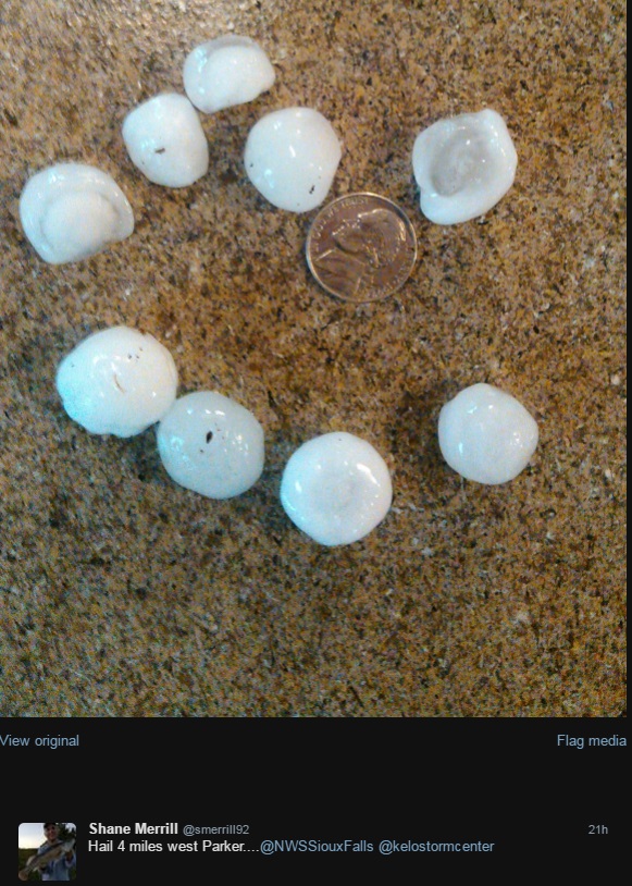
Turner |
4 NNE Parker |
SD |
HAIL |
1 |
emergency mngr |
|
| Wed Jun 14 2017 01:24:00 GMT-0500 (Central Daylight Time) |
Minnehaha |
7 W Wall Lake |
SD |
HAIL |
1 |
emergency mngr |
|
| Wed Jun 14 2017 01:30:00 GMT-0500 (Central Daylight Time) |
Turner |
3 SE Marion |
SD |
HAIL |
0.88 |
public |
report via social media. |
| Wed Jun 14 2017 01:30:00 GMT-0500 (Central Daylight Time) |
Turner |
1 NNE Hurley |
SD |
HAIL |
0.75 |
emergency mngr |
|
| Wed Jun 14 2017 01:36:00 GMT-0500 (Central Daylight Time) |
Turner |
Parker |
SD |
HAIL |
1.25 |
trained spotter |
relayed via turner county em. |
| Wed Jun 14 2017 01:40:00 GMT-0500 (Central Daylight Time) |
Turner |
1 E Parker |
SD |
HAIL |
1.5 |
public |
|
| Wed Jun 14 2017 01:40:00 GMT-0500 (Central Daylight Time) |
Minnehaha |
Hartford |
SD |
TSTM WND GST |
60 |
public |
|
| Wed Jun 14 2017 01:57:00 GMT-0500 (Central Daylight Time) |
Turner |
2 S Chancellor |
SD |
TSTM WND GST |
60 |
public |
|
| Wed Jun 14 2017 01:57:00 GMT-0500 (Central Daylight Time) |
Turner |
1 S Chancellor |
SD |
HAIL |
0.75 |
emergency mngr |
|
| Wed Jun 14 2017 02:05:00 GMT-0500 (Central Daylight Time) |
Minnehaha |
4 ESE Crooks |
SD |
TSTM WND GST |
75 |
trained spotter |
65 to 75 estimated. |
| Wed Jun 14 2017 02:07:00 GMT-0500 (Central Daylight Time) |
Minnehaha |
4 ENE Wall Lake |
SD |
HAIL |
1 |
emergency mngr |
|
| Wed Jun 14 2017 02:10:00 GMT-0500 (Central Daylight Time) |
Minnehaha |
3 W Sioux Falls |
SD |
TSTM WND DMG |
0 |
emergency mngr |
roof torn off of mobile home. |
| Wed Jun 14 2017 02:12:00 GMT-0500 (Central Daylight Time) |
Woodbury |
2 W Sergeant Bluff |
IA |
TSTM WND GST |
64 |
asos |
|
| Wed Jun 14 2017 02:13:00 GMT-0500 (Central Daylight Time) |
Minnehaha |
3 N Sioux Falls |
SD |
TSTM WND GST |
60 |
trained spotter |
estimated at nws office. |
| Wed Jun 14 2017 02:15:00 GMT-0500 (Central Daylight Time) |
Minnehaha |
3 SW Sioux Falls |
SD |
TSTM WND DMG |
0 |
public |
large tree uprooted. |
| Wed Jun 14 2017 02:15:00 GMT-0500 (Central Daylight Time) |
Clay |
5 SSE Centerville |
SD |
TSTM WND GST |
61 |
mesonet |
via sdsu mesonet beresford site. |
| Wed Jun 14 2017 02:15:00 GMT-0500 (Central Daylight Time) |
Woodbury |
2 N Salix |
IA |
TSTM WND GST |
70 |
trained spotter |
|
| Wed Jun 14 2017 02:16:00 GMT-0500 (Central Daylight Time) |
Lincoln |
Tea |
SD |
TSTM WND GST |
60 |
public |
|
| Wed Jun 14 2017 02:17:00 GMT-0500 (Central Daylight Time) |
Dakota |
South Sioux City |
NE |
TSTM WND DMG |
0 |
emergency mngr |
multiple reports of tree branches down around south sioux city. |
| Wed Jun 14 2017 02:20:00 GMT-0500 (Central Daylight Time) |
Minnehaha |
1 WSW Sioux Falls |
SD |
HAIL |
0.88 |
public |
|
| Wed Jun 14 2017 02:21:00 GMT-0500 (Central Daylight Time) |
Lincoln |
4 ENE Tea |
SD |
HAIL |
1 |
public |
hail just ended. |
| Wed Jun 14 2017 02:25:00 GMT-0500 (Central Daylight Time) |
Woodbury |
6 S Moville |
IA |
TSTM WND GST |
60 |
trained spotter |
|
| Wed Jun 14 2017 02:28:00 GMT-0500 (Central Daylight Time) |
Woodbury |
4 N Sioux City |
IA |
TSTM WND GST |
61 |
mesonet |
from cwop station wb0wnx. |
| Wed Jun 14 2017 02:30:00 GMT-0500 (Central Daylight Time) |
Minnehaha |
6 WNW Garretson |
SD |
HAIL |
1 |
public |
|
| Wed Jun 14 2017 02:30:00 GMT-0500 (Central Daylight Time) |
Union |
5 NW Alcester |
SD |
TSTM WND GST |
60 |
public |
report via social media. |
| Wed Jun 14 2017 02:34:00 GMT-0500 (Central Daylight Time) |
Plymouth |
Le Mars |
IA |
TSTM WND DMG |
0 |
law enforcement |
trees down in le mars. relayed via trained spotter on social media. time estimated from radar. |
| Wed Jun 14 2017 02:43:00 GMT-0500 (Central Daylight Time) |
Plymouth |
Remsen |
IA |
TSTM WND DMG |
0 |
law enforcement |
trees down in remsen. relayed via trained spotter on social media. time estimated from radar. |
| Wed Jun 14 2017 02:45:00 GMT-0500 (Central Daylight Time) |
Rock |
1 WSW Beaver Creek |
MN |
TSTM WND GST |
62 |
mesonet |
gust via beaver creek mndot rwis. |
| Wed Jun 14 2017 03:00:00 GMT-0500 (Central Daylight Time) |
Cherokee |
Cherokee |
IA |
TSTM WND DMG |
0 |
public |
tree split in cherokee. report via social media. |
| Wed Jun 14 2017 03:14:00 GMT-0500 (Central Daylight Time) |
O'Brien |
2 N Sheldon |
IA |
TSTM WND GST |
67 |
awos |
|
| Wed Jun 14 2017 03:16:00 GMT-0500 (Central Daylight Time) |
Lyon |
Marshall |
MN |
TSTM WND GST |
62 |
mesonet |
social media report via personal weather station. |
| Wed Jun 14 2017 03:24:00 GMT-0500 (Central Daylight Time) |
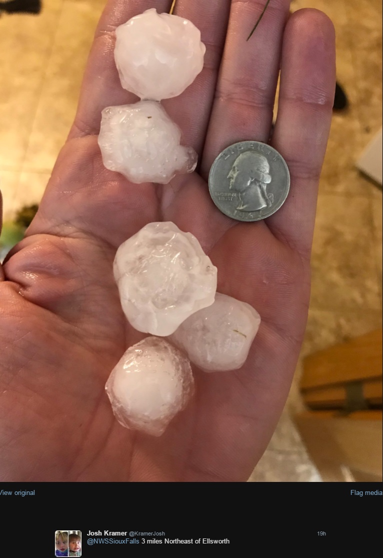
Nobles |
3 NE Ellsworth |
MN |
HAIL |
1 |
public |
social media report with picture. |
| Wed Jun 14 2017 03:55:00 GMT-0500 (Central Daylight Time) |
Cottonwood |
4 ENE Jeffers |
MN |
TSTM WND GST |
62 |
mesonet |
measured via mndot rwis. |


 Weather Story
 Weather Map
 Local Radar