Overview
An area of weakening thunderstorms moved out of Nebraska and across parts of northwest Iowa and southwest Minnesota between 3:30 and 5 AM CDT on May 16th. As these storms moved through, damaging winds of 50 to 80 mph were observed. These winds were also accompanied by a heat burst, which is a phenomenon where temperatures rise and dew points fall as strong winds associated with a thunderstorm move through an area.What causes a heat burst?
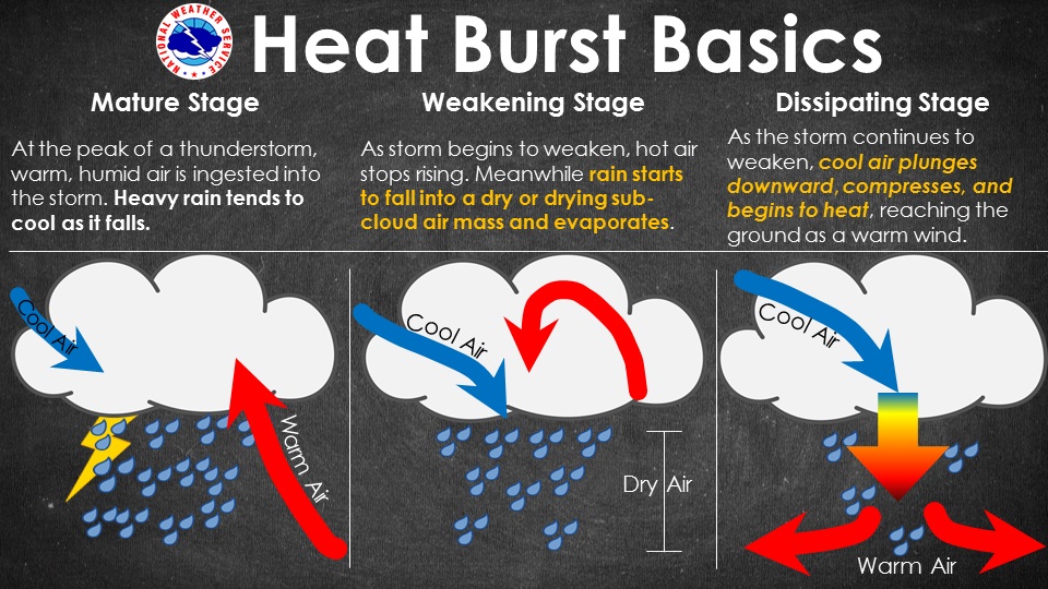
What causes a heat burst? When a thunderstorm is mature, warm and moist air rises into the storm. As the air rises, water drops (and ice crystals) form within the clouds which then fall out as heavy rain. With heavy rain falling, the air beneath the cloud is cooled due to evaporation. As a result, the air at the surface is typically cooler than the warm and moist air ahead of the thunderstorm. As the thunderstorm weakens, rainfall decreases. In most cases, when there is warm and moist air in the lowest 5000 feet of the atmosphere, the wind will decrease as the storm weakens and rain no longer reaches the surface. However, when there is very dry air below the cloud base, as occurred last night (see below), then evaporation continues below the cloud base. Where rain is evaporating, the colder air, which is denser than the air around it, will continue to accelerate toward the surface. Once the rain completely evaporates, the air will begin to warm more quickly as it approaches the surface. As it reaches the surface, the air is actually warmer and drier than the air ahead the storm.
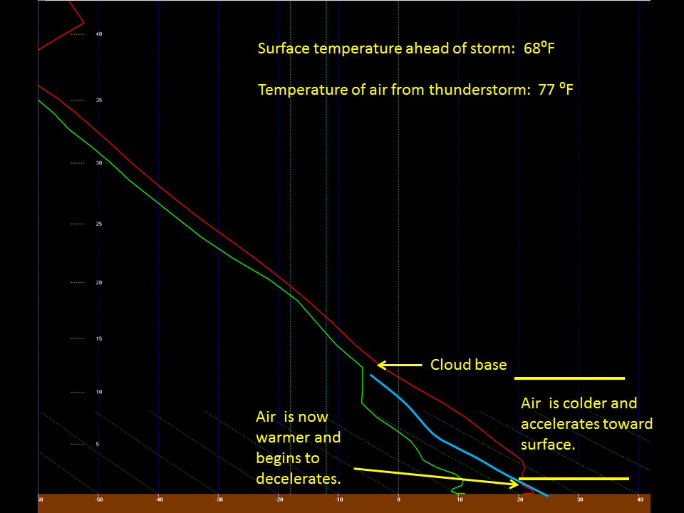
Above is graphic showing the estimated temperature (red line) and dew point (green line) near Spencer, Iowa at 4 AM CDT on May 16th. The blue line is the approximate temperature of the air associated with the weakening thunderstorm. Notice the very dry air below 10000 feet. As the rain falls into this air it will saturate and become cooler than the air around it and will begin to accelerate toward the surface. As long as there is rain, the air will remain cooler than the air outside the thunderstorm. However, once the rain has evaporated (around 5000 feet in the image above), then the air will begin to warm as it continues to approach the surface. A couple of thousand feet above the surface, the air from the thunderstorm will become warmer than the air around it. Below this level, the air will begin to decelerate. However, like a car that is going 60 mph, it takes time for the air slow down. In this case, there isn't enough time for the air to decelerate and it reaches the surface with wind speeds of 40-80 mph. With these winds, the temperature warms and dew points fall.
Sounding from the High Resolution Rapid Refresh Model
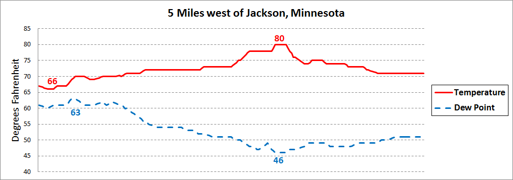
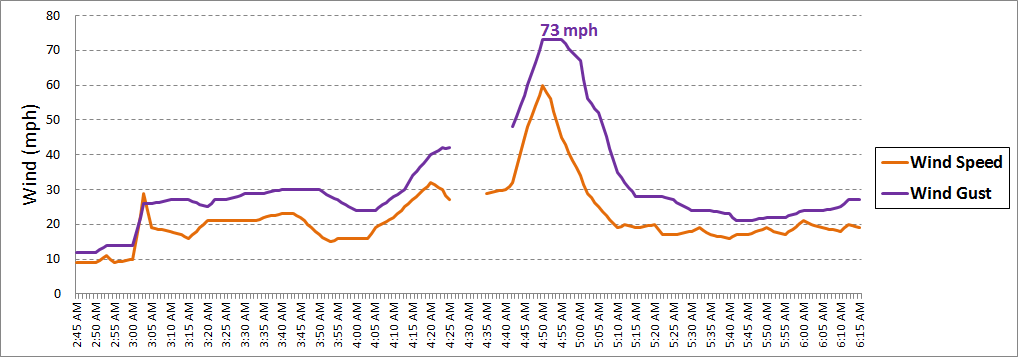
This graph shows the temperature, dew points, wind speed and wind gust from five miles west of Jackson, Minnesota. While the strongest winds occurred between 4:45 and 5:00 AM CDT, notice that the winds had already increased around 3:00 AM CDT when gusts up to 30 mph were observed. This dry air originated with thunderstorms that had dissipated over eastern Nebraska a couple of hours earlier. With the stronger winds, the temperature began to slowly rise and the dew points began to slowly fall. Between 4:20 and 5:00 AM CDT, dissipating showers and thunderstorms then moved over the area. Initially, winds increased to 30 to 50 mph. However, the last surge of wind with the storms resulted in a wind gust of 73 mph at 4:50 AM CDT. This is when the warmest and driest air moved over the area as the temperature reached 80 degrees - a 14 degree rise over two hours. The dew point also reached its low point of 46 degrees - 17 degrees lower than two hours earlier. Once the storms moved to the east, the winds quickly diminished and the temperature began to slowly fall.
Data Source: Minnesota Department of Transportation
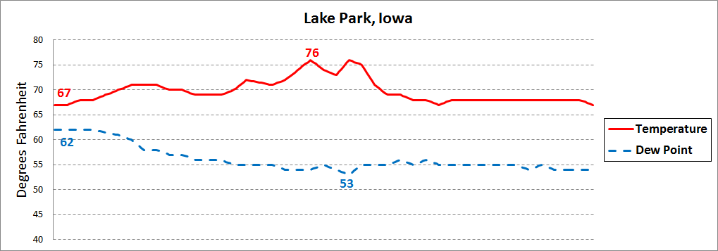
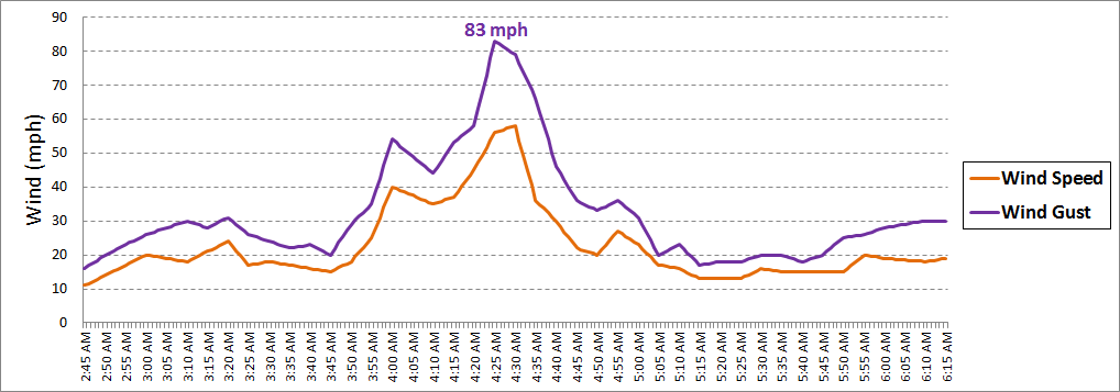
This data is from Lake Park, Iowa. While the temperature and dew point did not get as warm and dry as in Minnesota, the strongest winds were recorded at this location. Similar to near Jackson, the winds gradually increased after 3 AM CDT which resulted in a slow warming of the temperatures and a slow decrease in dew points. However, it was only as the showers reached Lake Park around 4;25 AM CDT that the strongest winds were observed. Unlike the site above, the dew point remained steady through 6:15 AM CDT even though the winds had decreased by 5 AM CDT.
Source: Mesowest Data
Photos & Video:
Header
 |
 |
 |
 |
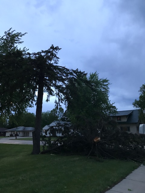
| Sheldon, IA tree damage (Courtesy of Jared Johnson) |
Sanborn, IA tree damage (Courtesy of Jared Johnson) |
Primghar, IA tree damage (Courtesy of Jared Johnson) |
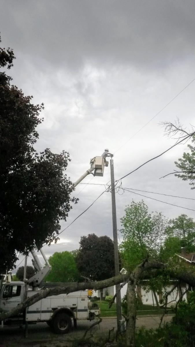
Electric crew make repairs after a fallen tree takes down a power line in Boyden, IA (Used with Permission) |
Radar:
Storm Reports
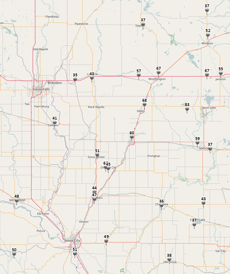
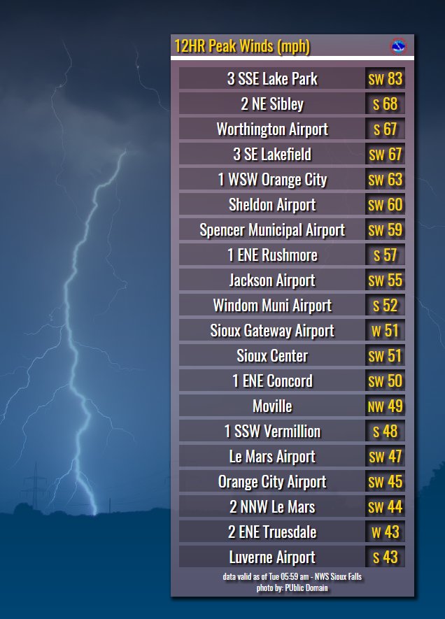
 |
Media use of NWS Web News Stories is encouraged! Please acknowledge the NWS as the source of any news information accessed from this site. |
 |