Overview
|
A strong winter storm brought accumulating snow, and life threatening cold to the entire region over the 16th and 17th. This storm system brought from 2 to 8 inches of snow in average across the entire area. A narrow snow band of 6 to 10 inches of snow developed east of the Interstate 29, and along the Interstate 90 across southwest Minnesota. Highest amounts were reported in Jackson, Minnesota with 10 inches of snow.
|
.PNG) Click on the Image for a Larger Version |
Photos and Images:
Radar and Images
.gif) |
 |
 |
 |
| Radar Loop of this Event |
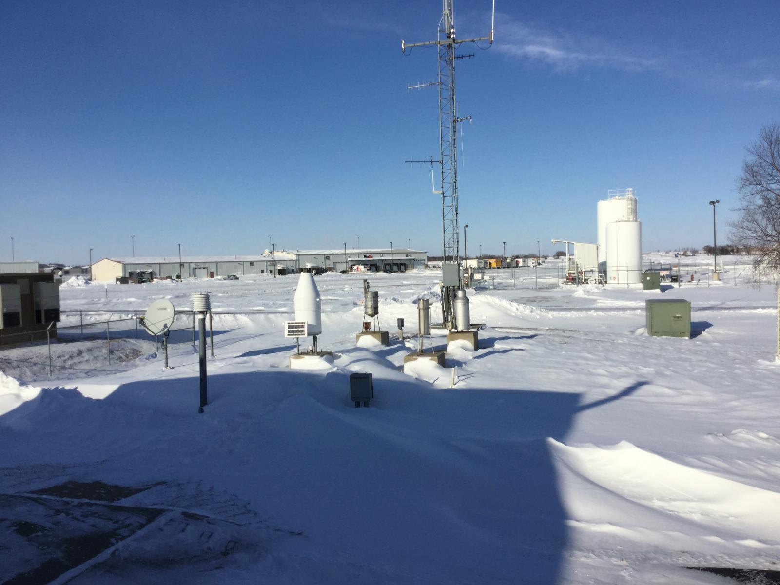
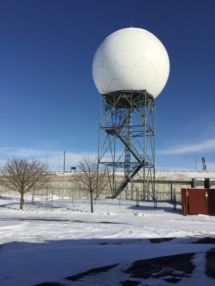
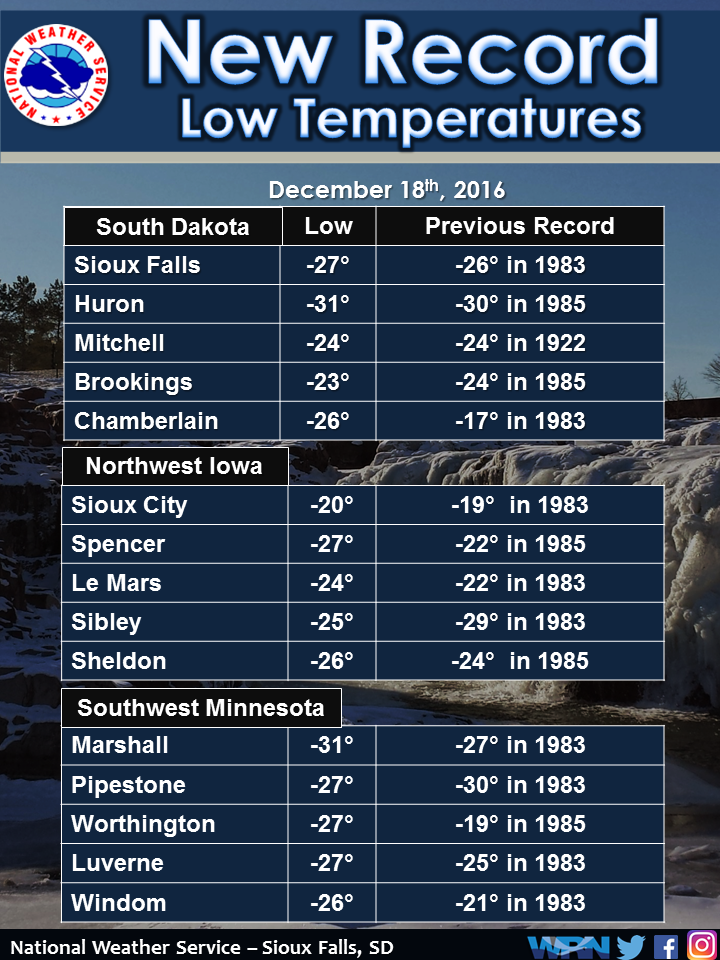
View from the NWS | View from the NWS | Record Lows for December 18 |
Storm Reports
1106 PM HEAVY SNOW JACKSON 43.62N 94.99W
12/16/2016 M10.0 INCH JACKSON MN PUBLIC
SOCIAL MEDIA REPORT.
1050 AM SNOW 1 SE TEA 43.44N 96.82W
12/17/2016 E8.6 INCH LINCOLN SD PUBLIC
.
1140 AM SNOW LUVERNE 43.65N 96.21W
12/17/2016 E7.8 INCH ROCK MN PUBLIC
.
1004 PM SNOW RUSHMORE 43.62N 95.80W
12/16/2016 M7.3 INCH NOBLES MN PUBLIC
SOCIAL MEDIA REPORT...SNOW ONGOING.
0600 AM SNOW HARTFORD 43.63N 96.94W
12/17/2016 M7.2 INCH MINNEHAHA SD COCORAHS
COCORAHS STATION HARTFORD /SD-MH-46/.
0700 AM SNOW 3 ESE SIOUX FALLS 43.53N 96.67W
12/17/2016 M7.2 INCH MINNEHAHA SD CO-OP OBSERVER
CO-OP OBSERVER STATION SIOUX FALLS 3ESE
/DEMS2/.
0700 AM SNOW 3 ESE SIOUX FALLS 43.52N 96.67W
12/17/2016 M7.2 INCH MINNEHAHA SD COCORAHS
COCORAHS STATION 3 ESE SIOUX FALLS
/SD-MH-1/.
0559 AM SNOW 3 NNW SIOUX FALLS 43.58N 96.75W
12/17/2016 M7.1 INCH MINNEHAHA SD ASOS
ASOS STATION SIOUX FALLS AIRPORT /FSD/.
0554 AM HEAVY SNOW 3 N SIOUX FALLS 43.59N 96.73W
12/17/2016 M7.1 INCH MINNEHAHA SD OFFICIAL NWS OBS
.
0600 AM SNOW 3 N SIOUX FALLS 43.59N 96.73W
12/17/2016 M7.1 INCH MINNEHAHA SD CO-OP OBSERVER
CO-OP OBSERVER STATION SIOUX FALLS NWS
/FSDS2/.
0700 AM SNOW SUPERIOR 43.43N 94.95W
12/17/2016 E7.0 INCH DICKINSON IA FIRE DEPT/RESCUE
.
0951 PM SNOW ADRIAN 43.63N 95.93W
12/16/2016 M7.0 INCH NOBLES MN PUBLIC
SNOW ONGOING.
0929 PM SNOW WORTHINGTON 43.63N 95.60W
12/16/2016 E7.0 INCH NOBLES MN PUBLIC
SOCIAL MEDIA REPORT...SNOW ONGOING.
0751 AM SNOW ROUND LAKE 43.54N 95.47W
12/17/2016 E7.0 INCH NOBLES MN PUBLIC
.
0700 AM SNOW 4 WNW ROWENA 43.55N 96.63W
12/17/2016 M7.0 INCH MINNEHAHA SD COCORAHS
COCORAHS STATION 3 WNW ROWENA /SD-MH-82/.
0830 AM SNOW 3 WSW SIOUX FALLS 43.52N 96.79W
12/17/2016 M6.6 INCH MINNEHAHA SD COCORAHS
COCORAHS STATION SIOUX FALLS 3.4 WSW
/SD-MH-23/.
0700 AM SNOW 1 WNW LAKEFIELD 43.68N 95.18W
12/17/2016 M6.6 INCH JACKSON MN CO-OP OBSERVER
CO-OP OBSERVER STATION LAKEFIELD /LKFM5/.
0900 AM SNOW 1 ENE WALL LAKE 43.53N 96.95W
12/17/2016 M6.5 INCH MINNEHAHA SD COCORAHS
COCORAHS STATION WALL LAKE /SD-MH-8/.
0932 PM SNOW 1 S BRANDON 43.58N 96.58W
12/16/2016 M6.5 INCH MINNEHAHA SD PUBLIC
SOCIAL MEDIA REPORT...SNOW ONGOING.
0700 AM SNOW 3 SSE LAKE PARK 43.41N 95.30W
12/17/2016 E6.5 INCH DICKINSON IA EMERGENCY MNGR
.
0655 AM SNOW CHAMBERLAIN 43.81N 99.33W
12/17/2016 M6.4 INCH BRULE SD COCORAHS
COCORAHS STATION CHAMBERLAIN /SD-BL-1/.
0900 AM SNOW 3 SSE SIOUX FALLS 43.50N 96.71W
12/17/2016 M6.3 INCH MINNEHAHA SD COCORAHS
COCORAHS STATION 3 SSE SIOUX FALLS
/SD-MH-7/.
0915 AM SNOW 3 SSE SIOUX FALLS 43.50N 96.71W
12/17/2016 E6.3 INCH MINNEHAHA SD PUBLIC
.
1002 PM SNOW 4 WNW TERRIL 43.33N 95.05W
12/16/2016 M6.3 INCH DICKINSON IA PUBLIC
SOCIAL MEDIA REPORT...SNOW ONGOING.
0845 AM SNOW 3 NNE SIOUX FALLS 43.58N 96.71W
12/17/2016 E6.2 INCH MINNEHAHA SD TRAINED SPOTTER
.
0700 AM SNOW 8 SSW CHAMBERLAIN 43.71N 99.38W
12/17/2016 M6.1 INCH BRULE SD COCORAHS
COCORAHS STATION 6 S OACOMA /SD-BL-10/.
0700 AM SNOW 3 NW EVERLY 43.18N 95.37W
12/17/2016 M6.0 INCH CLAY IA CO-OP OBSERVER
CO-OP OBSERVER STATION 3 WNW EVERLY /EVYI4/.
0700 AM SNOW 2 NNE WORTHINGTON 43.65N 95.58W
12/17/2016 M6.0 INCH NOBLES MN CO-OP OBSERVER
CO-OP OBSERVER STATION WORTHINGTON /WRNM5/.
0800 AM SNOW 1 SW BROOKINGS 44.29N 96.80W
12/17/2016 M6.0 INCH BROOKINGS SD COCORAHS
COCORAHS STATION 1 SW BROOKINGS /SD-BK-3/.
0600 PM SNOW 2 S HURON 44.34N 98.22W
12/16/2016 M6.0 INCH BEADLE SD OFFICIAL NWS OBS
STORM TOTAL SNOW...SNOW ONGOING.
0800 AM SNOW PIPESTONE 44.00N 96.31W
12/17/2016 M6.0 INCH PIPESTONE MN MESONET
MESONET STATION PIPESTONE /PIPM5/.
0555 AM SNOW 2 NNW HURON 44.39N 98.23W
12/17/2016 M6.0 INCH BEADLE SD ASOS
ASOS STATION HURON REGIONAL AIRPORT /HON/.
0900 AM SNOW 6 W MADISON 44.00N 97.23W
12/17/2016 M6.0 INCH LAKE SD CO-OP OBSERVER
CO-OP OBSERVER STATION 2 E MADISON /MRFS2/.
0700 AM SNOW 2 S PUKWANA 43.75N 99.18W
12/17/2016 M6.0 INCH BRULE SD COCORAHS
COCORAHS STATION 1 S PUKWANA /SD-BL-11/.
0630 PM SNOW BREWSTER 43.70N 95.47W
12/16/2016 M6.0 INCH NOBLES MN PUBLIC
.
1056 PM SNOW 2 SW SIOUX FALLS 43.52N 96.76W
12/16/2016 M5.9 INCH MINNEHAHA SD BROADCAST MEDIA
SNOW ONGOING.
1000 PM SNOW MILFORD 43.33N 95.15W
12/16/2016 M5.8 INCH DICKINSON IA PUBLIC
SOCIAL MEDIA REPORT...SNOW ONGOING.
0700 AM SNOW 4 NNE SIBLEY 43.45N 95.71W
12/17/2016 M5.8 INCH OSCEOLA IA CO-OP OBSERVER
CO-OP OBSERVER STATION SIBLEY /SIBI4/.
0700 AM SNOW 4 SW SIOUX FALLS 43.50N 96.79W
12/17/2016 M5.7 INCH MINNEHAHA SD COCORAHS
COCORAHS STATION 3 SW SIOUX FALLS
/SD-MH-41/.
1000 AM SNOW 1 S HURON 44.35N 98.22W
12/17/2016 M5.5 INCH BEADLE SD COCORAHS
COCORAHS STATION 1 S HURON /SD-BD-20/.
1045 AM SNOW ARMOUR 43.32N 98.34W
12/17/2016 E5.5 INCH DOUGLAS SD EMERGENCY MNGR
.
1034 PM SNOW ROCK RAPIDS 43.43N 96.17W
12/16/2016 M5.5 INCH LYON IA PUBLIC
SOCIAL MEDIA REPORT...SNOW ONGOING.
0747 PM SNOW 4 N CURRIE 44.13N 95.68W
12/16/2016 M5.5 INCH MURRAY MN AMATEUR RADIO
.
0800 AM SNOW 2 SW SIOUX FALLS 43.53N 96.76W
12/17/2016 M5.4 INCH MINNEHAHA SD COCORAHS
COCORAHS STATION 1 SW SIOUX FALLS
/SD-MH-86/.
0700 AM SNOW 2 N CHESTER 43.93N 96.93W
12/17/2016 M5.2 INCH LAKE SD CO-OP OBSERVER
CO-OP OBSERVER STATION CHESTER 2N /CHES2/.
0950 PM SNOW LAKE PARK 43.45N 95.32W
12/16/2016 M5.2 INCH DICKINSON IA PUBLIC
SOCIAL MEDIA REPORT...SNOW ONGOING.
0700 AM SNOW 3 ESE DIXON 43.36N 99.42W
12/17/2016 M5.0 INCH GREGORY SD COCORAHS
COCORAHS STATION GREGORY 8.7 N /SD-GY-3/.
0700 AM SNOW WESTBROOK 44.04N 95.43W
12/17/2016 E5.0 INCH COTTONWOOD MN PUBLIC
.
0920 PM SNOW 3 NE CROOKS 43.69N 96.77W
12/16/2016 M5.0 INCH MINNEHAHA SD PUBLIC
SOCIAL MEDIA REPORT...SNOW ONGOING.
0700 AM SNOW 2 NE BURKE 43.21N 99.26W
12/17/2016 M5.0 INCH GREGORY SD COCORAHS
COCORAHS STATION BURKE 2.4 NE /SD-GY-17/.
0700 AM SNOW 1 WNW CANTON 43.31N 96.59W
12/17/2016 M5.0 INCH LINCOLN SD CO-OP OBSERVER
CO-OP OBSERVER STATION CANTON /CNNS2/.
0954 PM SNOW 5 SW IRENE 43.03N 97.23W
12/16/2016 M5.0 INCH YANKTON SD PUBLIC
SOCIAL MEDIA REPORT...SNOW ONGOING.
0630 AM SNOW 2 ESE YANKTON 42.88N 97.36W
12/17/2016 M5.0 INCH YANKTON SD CO-OP OBSERVER
CO-OP OBSERVER STATION 2 SE YANKTON /YTNS2/.
0700 AM SNOW WHITE LAKE 43.73N 98.72W
12/17/2016 M5.0 INCH AURORA SD CO-OP OBSERVER
CO-OP OBSERVER STATION WHITE LAKE /WITS2/.
1150 PM SNOW 2 S MITCHELL 43.70N 98.04W
12/16/2016 M4.9 INCH DAVISON SD CO-OP OBSERVER
CO-OP OBSERVER STATION MITCHELL /MCLS2/.
0556 AM SNOW 3 N MITCHELL 43.77N 98.04W
12/17/2016 M4.9 INCH DAVISON SD ASOS
ASOS STATION MITCHELL MUNICIPAL AIRPORT
/MHE/.
1002 PM SNOW ROCK RAPIDS 43.43N 96.17W
12/16/2016 M4.8 INCH LYON IA PUBLIC
SOCIAL MEDIA REPORT...SNOW ONGOING.
0830 AM SNOW 7 NNE CHAMBERLAIN 43.90N 99.25W
12/17/2016 M4.6 INCH BRULE SD COCORAHS
COCORAHS STATION CHAMBERLAIN 7.5 NNE
/SD-BL-13/.
0700 AM SNOW 2 SSW GAYVILLE 42.86N 97.18W
12/17/2016 M4.5 INCH YANKTON SD COCORAHS
COCORAHS STATION GAYVILLE 1.8 SSW /SD-YN-3/.
0738 PM SNOW 2 SSE MITCHELL 43.70N 98.02W
12/16/2016 M4.5 INCH DAVISON SD PUBLIC
SOCIAL MEDIA REPORT.
0800 PM SNOW ELLSWORTH 43.52N 96.02W
12/16/2016 M4.5 INCH NOBLES MN PUBLIC
SNOW ONGOING.
1006 AM SNOW SUTHERLAND 42.97N 95.50W
12/17/2016 U4.5 INCH O`BRIEN IA PUBLIC
.
1151 AM SNOW BOYDEN 43.19N 96.00W
12/17/2016 E4.5 INCH SIOUX IA PUBLIC
FROM SOCIAL MEDIA.
0700 AM SNOW 1 SE VERMILLION 42.77N 96.91W
12/17/2016 M4.5 INCH CLAY SD COCORAHS
COCORAHS STATION 1 ESE VERMILLION
/SD-CY-10/.
1000 PM SNOW 4 SSE SIOUX FALLS 43.49N 96.71W
12/16/2016 M4.3 INCH LINCOLN SD NWS EMPLOYEE
SNOW ONGOING.
0934 PM SNOW HERON LAKE 43.80N 95.32W
12/16/2016 M4.3 INCH JACKSON MN PUBLIC
SOCIAL MEDIA REPORT...SNOW ONGOING.
0931 PM SNOW DELL RAPIDS 43.83N 96.72W
12/16/2016 M4.3 INCH MINNEHAHA SD PUBLIC
SOCIAL MEDIA REPORT...SNOW ONGOING.
0900 PM SNOW 3 SSE SIOUX FALLS 43.50N 96.71W
12/16/2016 M4.3 INCH MINNEHAHA SD TRAINED SPOTTER
STORM TOTAL SNOW...SNOW ONGOING.
0700 AM SNOW SHELDON 43.18N 95.85W
12/17/2016 M4.1 INCH O`BRIEN IA CO-OP OBSERVER
CO-OP OBSERVER STATION SHELDON /SHDI4/.
0700 AM SNOW 9 S DALLAS 43.11N 99.49W
12/17/2016 M4.0 INCH GREGORY SD COCORAHS
COCORAHS STATION 8 S DALLAS /SD-GY-1/.
1103 AM SNOW PIPESTONE 44.00N 96.32W
12/17/2016 E4.0 INCH PIPESTONE MN PUBLIC
.
0935 PM SNOW ROCK VALLEY 43.20N 96.30W
12/16/2016 M4.0 INCH SIOUX IA PUBLIC
SOCIAL MEDIA REPORT...SNOW ONGOING.
0700 AM SNOW 4 SW BURKE 43.14N 99.35W
12/17/2016 M4.0 INCH GREGORY SD COCORAHS
COCORAHS STATION 4 SW BURKE /SD-GY-15/.
1033 PM SNOW 5 WSW SIOUX FALLS 43.53N 96.83W
12/16/2016 M4.0 INCH MINNEHAHA SD PUBLIC
SOCIAL MEDIA REPORT...SNOW ONGOING.
0900 PM SNOW 3 SW SIOUX FALLS 43.51N 96.77W
12/16/2016 M4.0 INCH MINNEHAHA SD BROADCAST MEDIA
STORM TOTAL SNOW...SNOW ONGOING.
0950 PM SNOW 1 SSW PIPESTONE 43.99N 96.33W
12/16/2016 M4.0 INCH PIPESTONE MN PUBLIC
SOCIAL MEDIA REPORT...SNOW ONGOING.
0600 AM SNOW AURORA 44.28N 96.69W
12/17/2016 E4.0 INCH BROOKINGS SD PUBLIC
REPORTED VIA SOCIAL MEDIA.
0947 PM SNOW LAKE BENTON 44.26N 96.30W
12/16/2016 M4.0 INCH LINCOLN MN TRAINED SPOTTER
SNOW ONGOING.
0845 AM SNOW 3 N SIOUX CENTER 43.12N 96.17W
12/17/2016 E4.0 INCH SIOUX IA COCORAHS
.
0944 PM SNOW 1 W MADISON 44.01N 97.13W
12/16/2016 M4.0 INCH LAKE SD EMERGENCY MNGR
SNOW ONGOING.
0700 AM SNOW 3 N SIOUX CENTER 43.11N 96.18W
12/17/2016 M4.0 INCH SIOUX IA COCORAHS
COCORAHS STATION 2 NNW SIOUX CENTER
/IA-SX-7/.
0742 PM SNOW 2 S MITCHELL 43.70N 98.04W
12/16/2016 M3.9 INCH DAVISON SD CO-OP OBSERVER
STORM TOTAL SNOW...LIGHT SNOW ONGOING.
0700 PM SNOW IROQUOIS 44.36N 97.85W
12/16/2016 M3.7 INCH KINGSBURY SD CO-OP OBSERVER
.
0630 AM SNOW HOWARD 44.02N 97.52W
12/17/2016 M3.6 INCH MINER SD CO-OP OBSERVER
CO-OP OBSERVER STATION HOWARD /HOWS2/.
0800 AM SNOW LAKE WILSON 44.00N 95.95W
12/17/2016 M3.5 INCH MURRAY MN CO-OP OBSERVER
CO-OP OBSERVER STATION LAKE WILSON /LKWM5/.
0700 AM SNOW 8 SSW HERRICK 43.00N 99.23W
12/17/2016 M3.5 INCH GREGORY SD COCORAHS
COCORAHS STATION 7 WNW NAPER /SD-GY-12/.
0800 AM SNOW 5 W BRUCE 44.43N 97.00W
12/17/2016 M3.5 INCH BROOKINGS SD COCORAHS
COCORAHS STATION 5 W BRUCE /SD-BK-45/.
1200 AM SNOW 4 NW OKOBOJI 43.43N 95.18W
12/17/2016 M3.5 INCH DICKINSON IA CO-OP OBSERVER
CO-OP OBSERVER STATION VICKS CORNER-SPIRIT
LAKE IOWA /VICI4/.
0700 AM SNOW 1 S BROOKINGS 44.29N 96.79W
12/17/2016 M3.5 INCH BROOKINGS SD COCORAHS
COCORAHS STATION 1 S BROOKINGS /SD-BK-43/.
0700 AM SNOW 1 S MARSHALL 44.44N 95.79W
12/17/2016 M3.5 INCH LYON MN COCORAHS
COCORAHS STATION MARSHALL 0.6 S /MN-LY-2/.
0800 AM SNOW TYNDALL 42.99N 97.86W
12/17/2016 M3.5 INCH BON HOMME SD CO-OP OBSERVER
CO-OP OBSERVER STATION TYNDALL /TYNS2/.
0700 AM SNOW BROOKINGS 44.30N 96.79W
12/17/2016 M3.2 INCH BROOKINGS SD COCORAHS
COCORAHS STATION BROOKINGS /SD-BK-7/.
0830 PM SNOW PIPESTONE 44.00N 96.32W
12/16/2016 M3.0 INCH PIPESTONE MN PUBLIC
SNOW ONGOING.
0546 PM SNOW ROCK RAPIDS 43.43N 96.17W
12/16/2016 M3.0 INCH LYON IA PUBLIC
SOCIAL MEDIA REPORT...SNOW ONGOING.
0905 AM SNOW 4 SE SIOUX CITY 42.46N 96.34W
12/17/2016 E3.0 INCH WOODBURY IA TRAINED SPOTTER
.
1000 AM SNOW 6 NNE ELK POINT 42.76N 96.65W
12/17/2016 M3.0 INCH UNION SD COCORAHS
COCORAHS STATION 2 W WESTFIELD /SD-UN-2/.
0330 PM SNOW 1 SSE MITCHELL 43.71N 98.03W
12/16/2016 M3.0 INCH DAVISON SD BROADCAST MEDIA
.
0800 AM SNOW 1 NNW MARSHALL 44.47N 95.80W
12/17/2016 M3.0 INCH LYON MN CO-OP OBSERVER
CO-OP OBSERVER STATION MARSHALL /MMLM5/.
1133 PM SNOW BOYDEN 43.19N 96.00W
12/16/2016 M3.0 INCH SIOUX IA PUBLIC
SOCIAL MEDIA REPORT.
1000 AM SNOW 1 SSE VERMILLION 42.76N 96.92W
12/17/2016 M3.0 INCH CLAY SD CO-OP OBSERVER
CO-OP OBSERVER STATION 2 SE VERMILLION
/VRMS2/.
0700 AM SNOW DE SMET 44.38N 97.55W
12/17/2016 M3.0 INCH KINGSBURY SD COCORAHS
COCORAHS STATION DE SMET /SD-KY-5/.
0700 AM SNOW ORANGE CITY 43.00N 96.05W
12/17/2016 M3.0 INCH SIOUX IA CO-OP OBSERVER
CO-OP OBSERVER STATION ORANGE CITY /ORCI4/.
0800 AM SNOW 1 ESE WHITE 44.43N 96.62W
12/17/2016 M3.0 INCH BROOKINGS SD COCORAHS
COCORAHS STATION 1 ESE WHITE /SD-BK-33/.
0800 AM SNOW 1 NE BROOKINGS 44.32N 96.77W
12/17/2016 M3.0 INCH BROOKINGS SD CO-OP OBSERVER
CO-OP OBSERVER STATION 2 NE BROOKINGS
/BROS2/.
0945 PM SNOW 1 S MARSHALL 44.44N 95.79W
12/16/2016 M3.0 INCH LYON MN TRAINED SPOTTER
.
0845 PM SNOW SHELDON 43.18N 95.85W
12/16/2016 M3.0 INCH O`BRIEN IA CO-OP OBSERVER
.
0930 PM SNOW 1 S WINDOM 43.86N 95.12W
12/16/2016 M2.8 INCH COTTONWOOD MN CO-OP OBSERVER
SNOW ONGOING.
0445 PM SNOW MADISON 44.01N 97.11W
12/16/2016 M2.8 INCH LAKE SD EMERGENCY MNGR
.
1045 AM SNOW 2 SSE NORTH SIOUX CITY 42.50N 96.49W
12/17/2016 E2.7 INCH UNION SD BROADCAST MEDIA
.
0700 AM SNOW 11 N COLMAN 44.14N 96.80W
12/17/2016 M2.5 INCH MOODY SD COCORAHS
COCORAHS STATION COLMAN 10.6 N /SD-MY-11/.
0730 AM SNOW PICKSTOWN 43.07N 98.53W
12/17/2016 M2.5 INCH CHARLES MIX SD CO-OP OBSERVER
CO-OP OBSERVER STATION PICKSTOWN /PKSS2/.
0708 PM SNOW TEA 43.45N 96.84W
12/16/2016 M2.5 INCH LINCOLN SD PUBLIC
.
1200 AM SNOW TYNDALL 42.99N 97.87W
12/17/2016 M2.5 INCH BON HOMME SD CO-OP OBSERVER
.
0900 AM SNOW 1 WSW SIOUX CITY 42.50N 96.41W
12/17/2016 E2.5 INCH WOODBURY IA BROADCAST MEDIA
2-3 INCHES OF SNOW ON THE NORTHSIDE OF SIOUX
CITY.
0700 AM SNOW 1 NNW AKRON 42.84N 96.56W
12/17/2016 M2.4 INCH PLYMOUTH IA MESONET
MESONET STATION AKRON /AKRI4/.
0400 PM SNOW 4 ESE SIOUX FALLS 43.53N 96.66W
12/16/2016 M2.2 INCH MINNEHAHA SD NWS EMPLOYEE
.
0552 AM SNOW 1 WSW SERGEANT BLUFF 42.39N 96.38W
12/17/2016 M2.2 INCH WOODBURY IA ASOS
ASOS STATION SIOUX GATEWAY AIRPORT /SUX/.
0450 AM SNOW 1 E LE MARS 42.79N 96.15W
12/17/2016 E2.2 INCH PLYMOUTH IA TRAINED SPOTTER
REPORTED VIA SOCIAL MEDIA.
1100 AM SNOW REMSEN 42.81N 95.98W
12/17/2016 M2.1 INCH PLYMOUTH IA CO-OP OBSERVER
CO-OP OBSERVER STATION REMSEN NO. 2 /RMSI4/.
0800 AM SNOW 2 S ORANGE CITY 42.97N 96.06W
12/17/2016 M2.0 INCH SIOUX IA COCORAHS
COCORAHS STATION 2 S ORANGE CITY /IA-SX-6/.
0345 PM SNOW 4 WNW ROWENA 43.54N 96.62W
12/16/2016 M2.0 INCH MINNEHAHA SD NWS EMPLOYEE
.
0500 PM SNOW TYNDALL 42.99N 97.87W
12/16/2016 M1.8 INCH BON HOMME SD CO-OP OBSERVER
SNOW ONGOING.
0114 AM SNOW LE MARS 42.79N 96.17W
12/17/2016 E1.5 INCH PLYMOUTH IA PUBLIC
.
0244 PM SNOW 3 SW SIOUX FALLS 43.51N 96.77W
12/16/2016 M1.3 INCH MINNEHAHA SD BROADCAST MEDIA
.
0600 PM SNOW SERGEANT BLUFF 42.40N 96.36W
12/16/2016 M1.0 INCH WOODBURY IA OFFICIAL NWS OBS
.
1235 AM SNOW PONCA 42.57N 96.71W
12/17/2016 M1.0 INCH DIXON NE PUBLIC
SOCIAL MEDIA REPORT.
0345 PM SNOW 1 NNW PIPESTONE 44.01N 96.32W
12/16/2016 M1.0 INCH PIPESTONE MN PUBLIC
.
0330 PM SNOW 1 NNW SHELDON 43.19N 95.85W
12/16/2016 M1.0 INCH O`BRIEN IA CO-OP OBSERVER
.
0600 AM SNOW SERGEANT BLUFF 42.41N 96.36W
12/17/2016 M0.6 INCH WOODBURY IA CO-OP OBSERVER
CO-OP OBSERVER STATION SNOW PAID FOR KSUX
/SUXI4/.
0338 PM SNOW 2 SSE SIOUX CENTER 43.06N 96.15W
12/16/2016 M0.5 INCH SIOUX IA CO-OP OBSERVER
.
0800 AM SNOW 2 E CONCORD 42.38N 96.96W
12/17/2016 M0.5 INCH DIXON NE CO-OP OBSERVER
CO-OP OBSERVER STATION NORTHEAST EXPERIMENT
STATION /NESN1/.
0543 PM SNOW 2 SSE NORTH SIOUX CITY 42.50N 96.49W
12/16/2016 M0.5 INCH UNION SD BROADCAST MEDIA
 |
Media use of NWS Web News Stories is encouraged! Please acknowledge the NWS as the source of any news information accessed from this site. |
|


 Weather Story
 Weather Map
 Local Radar