Overview
|
Scattered thunderstorms which developed along a frontal boundary stretched across portions of northwestern Iowa and southwestern Minnesota produced a wide array of severe weather during the evening of the 23rd of May. As these storms formed, they were capable of producing very weak landspout tornadoes, one of which briefly touched down near the city of Hospers, IA. However, as they continued to grow, the tornado risk diminished and reports of large hail up to ping pong ball size and damaging winds were received. Due to the steady northeastward movement of these storms along a front in the area, heavy rainfall was reported in many areas. By Tuesday morning, rainfall totals were as high as 2 to 4 inches in some locations.
|
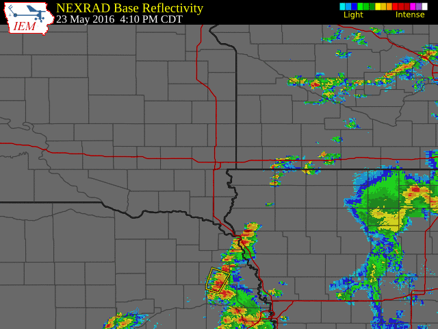 Radar from Tuesday May 23rd |
Storm Reports
..TIME... ...EVENT... ...CITY LOCATION... ...LAT.LON...
..DATE... ....MAG.... ..COUNTY LOCATION..ST.. ...SOURCE....
..REMARKS..
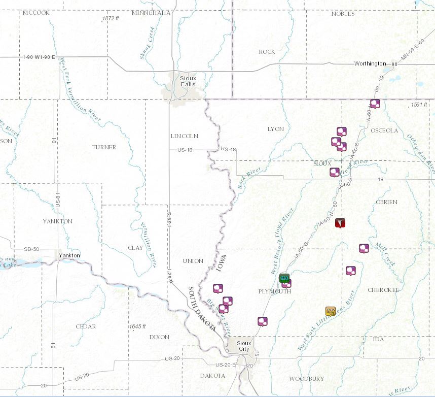
0438 PM HAIL HINTON 42.62N 96.29W
05/23/2016 E1.50 INCH PLYMOUTH IA LAW ENFORCEMENT
0441 PM TORNADO 2 N GRANVILLE 43.01N 95.87W
05/23/2016 SIOUX IA LAW ENFORCEMENT
0448 PM HAIL 1 SSE LE MARS 42.77N 96.16W
05/23/2016 E0.25 INCH PLYMOUTH IA TRAINED SPOTTER
ALSO VERY HEAVY RAIN, STORM DRAINS
OVERFLOWING.
0535 PM HAIL 8 SE WESTFIELD 42.67N 96.50W
05/23/2016 E1.00 INCH PLYMOUTH IA PUBLIC
0540 PM HAIL 8 ESE WESTFIELD 42.70N 96.48W
05/23/2016 E0.88 INCH PLYMOUTH IA PUBLIC
0542 PM HAIL 3 SSE MATLOCK 43.21N 95.90W
05/23/2016 E1.00 INCH SIOUX IA TRAINED SPOTTER
ALSO ESTIMATED 45 MPH WIND GUSTS.
0555 PM FLASH FLOOD LE MARS 42.79N 96.17W
05/23/2016 PLYMOUTH IA PUBLIC
STREETS FLOODED AND OVER RAILROAD TRACKS
0558 PM HAIL 4 W ASHTON 43.31N 95.86W
05/23/2016 E1.00 INCH LYON IA TRAINED SPOTTER
0602 PM HAIL 4 E WESTFIELD 42.75N 96.53W
05/23/2016 E1.00 INCH PLYMOUTH IA PUBLIC
0605 PM HAIL 5 WNW ASHTON 43.33N 95.89W
05/23/2016 E1.00 INCH LYON IA TRAINED SPOTTER
0608 PM HAIL 5 S LITTLE ROCK 43.37N 95.86W
05/23/2016 E1.00 INCH LYON IA TRAINED SPOTTER
0620 PM HAIL 6 NNE SIBLEY 43.48N 95.68W
05/23/2016 E1.00 INCH OSCEOLA IA TRAINED SPOTTER
MOST OF THE HAIL WAS PEA TO DIME SIZE WITH A
FEW QUARTER SIZE.
0625 PM TSTM WND GST 6 NNE KINGSLEY 42.66N 95.92W
05/23/2016 M82 MPH PLYMOUTH IA PUBLIC
2 TO 6 INCH DIAMETER BRANCHES BROKEN OFF
TREES. WEATHER STATION BLOWN OFF GARAGE.
0643 PM HAIL MARCUS 42.82N 95.81W
05/23/2016 E1.50 INCH CHEROKEE IA TRAINED SPOTTER
MOSTLY PEA, WITH A FEW PING PONG BALL SIZE
0655 PM HAIL 5 SSW PAULLINA 42.91N 95.74W
05/23/2016 E0.88 INCH O`BRIEN IA TRAINED SPOTTER
 |
Media use of NWS Web News Stories is encouraged! Please acknowledge the NWS as the source of any news information accessed from this site. |
|


 Weather Story
 Weather Map
 Local Radar