Sioux Falls, SD
Weather Forecast Office
Wednesday evening, strong supercell thunderstorms moved through portions of north central South Dakota. These tornadic storms directly impacted the city of Wessington Springs, SD. Here are the results of a preliminary damage survey for the city.
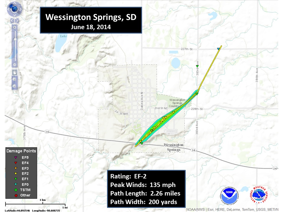
Rating: EF-2
Peak wind: 135 mph
Path length: 2.26 miles
Path Width: 200 yards
Fatalities: none
Injuries: none
The Enhanced Fujita scale classifies tornadoes into the following categories.
Ef0...Weak......65 to 85 mph
Ef1...Weak......86 to 110 mph
Ef2...Strong....111 to 135 mph
Ef3...Strong....136 to 165 mph
Ef4...Violent...166 to 200 mph
Ef5...Violent...>200 mph*
Popular Pages
Past Weather Events
Regional Weather Roundup
Daily Temp/Precip
Hazardous Weather
Local Climate Archives
Climate Graphs and Data
Seasonal
EvapoTranspiration
Fire Weather
Grassland Fire Danger
Flooding (River)
Summer Weather
Travel Forecasts
Winter Weather
Winter Preparedness
Forecast Snowfall Graphic
Winter Temp Climatology
US Dept of Commerce
National Oceanic and Atmospheric Administration
National Weather Service
Sioux Falls, SD
26 Weather Lane
Sioux Falls, SD 57104-0198
605-330-4247
Comments? Questions? Please Contact Us.


 Weather Story
 Weather Map
 Local Radar