National Weather Service United States Department of Commerce

Locally Heavy Rainfall for the Carolinas; Thunderstorms and Fire Weather Concerns for Intermountain West

Heavy rainfall from scattered thunderstorms is expected across the Southwest, Intermountain West, and Plains. Isolated dry thunderstorms may initiate additional fires across the west. The coastal Carolinas may experience flash floods in the coming days due to repeated thunderstorms. Additionally, a wave of intense summer heat will hit the Southern Plains and central Gulf Coast States this week. Read More >


A band of heavy snowfall developed during the afternoon across the area, bringing widespread snowfall of 5 to 10 inches to much of southwest Minnesota and northwest Iowa. Many areas also received a mix of rain and sleet leading into the later day snowfall, bringing a solid dose of needed moisture to the area.

Storm total snowfall from April 3 2014

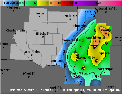
24 HOUR SNOWFALL DATA IN INCHES...FOR SOUTHEAST SOUTH DAKOTA...
SOUTHWEST MINNESOTA...NORTHWEST IOWA...AND NORTHEAST NEBRASKA...
RECEIVED BY 10:15 AM FRIDAY APRIL 4 2014.

...SOUTHEAST SOUTH DAKOTA...

  7 WSW FAIRVIEW                           7.0
  NORTH SIOUX CITY                         3.8
  4 ESE SIOUX FALLS                        3.6
  4 ESE SIOUX FALLS                        3.4
  3 ESE SIOUX FALLS                        3.4
  4 SW SIOUX FALLS                         2.6
  3 N SIOUX FALLS                          2.6
  1 ENE WALL LAKE                          2.5
  3 NE CROOKS                              1.8
  2 SSW GAYVILLE                           1.0
  2 ESE YANKTON                            1.0
  FLANDREAU                                0.2
  SE MARION                                0.0
  2 N CHESTER                              0.0
  2 S MITCHELL                             0.0

...SOUTHWEST MINNESOTA...

  1 S WINDOM                               9.7
  2 NNE WORTHINGTON                        9.0
  WESTBROOK                                8.0
  E HERON LAKE                             7.0
  1 WNW LAKEFIELD                          6.7
  1 W MOUNTAIN LAKE                        6.0
  1 NNE LUVERNE                            6.0
  S FULDA                                  6.0
  JACKSON                                  6.0
  SLAYTON                                  5.0
  ADRIAN                                   5.0
  1 N MARSHALL                             1.5
  6 N PIPESTONE                            1.5
  1 S MARSHALL                             1.3

...NORTHWEST IOWA...

  SUTHERLAND                               8.0
  4 NNE SIBLEY                             7.8
  3 NW EVERLY                              7.0
  SHELDON                                  6.5
  LE MARS                                  6.5
  SSE LAKE PARK                            6.0
  LESTER                                   6.0
  SIOUX CENTER                             6.0
  1 W SPIRIT LAKE                          5.8
  BRUNSVILLE                               5.4
  W LARCHWOOD                              5.0
  1 ENE CHEROKEE                           5.0
  1 N ROCK RAPIDS                          5.0
  1 NNE ROCK VALLEY                        5.0
  ORANGE CITY                              4.6
  ORANGE CITY                              4.6
  4 E SIOUX RAPIDS                         4.5
  E PETERSON                               4.5
  2 S ORANGE CITY                          4.0
  1 SE STORM LAKE                          4.0
  1 ESE ALTON                              4.0
  HOLSTEIN                                 4.0
  WASHTA                                   3.6
  5 N SIOUX CITY                           3.5
  3 N HORNICK                              3.0
  4 NNE BATTLE CREEK                       2.4
  N SIOUX CITY                             2.1
  1 WSW SERGEANT BLUFF                     0.5