National Weather Service United States Department of Commerce

Locally Heavy Rainfall for the Carolinas; Thunderstorms and Fire Weather Concerns for Intermountain West

Heavy rainfall from scattered thunderstorms is expected across the Southwest, Intermountain West, and Plains. Isolated dry thunderstorms may initiate additional fires across the west. The coastal Carolinas may experience flash floods in the coming days due to repeated thunderstorms. Additionally, a wave of intense summer heat will hit the Southern Plains and central Gulf Coast States this week. Read More >

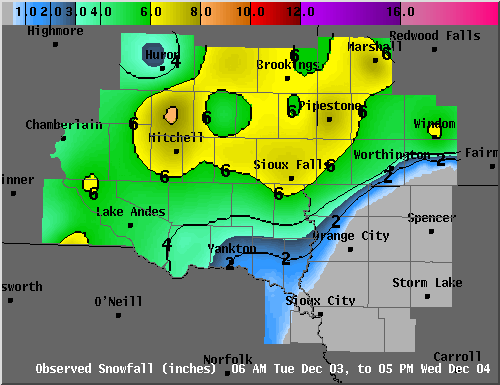
Below is a map of snowfall amounts from December 3-4, 2013. This map is an interpolation of reports received from various sources. In locations where data is more sparse, the map may not exactly reflect the amount of snow received in those locations. Overall, this event produced a wide swath of 4 to 7 inches from south central South Dakota, into southwest Minnesota, with a sharp cutoff to less than an inch of snowfall over much of northwest Iowa.

Contoured map of snowfall reports for December 3rd and 4th, 2013

Event Totals Snowfall in inches

Reports Received by 6 PM Wednesday December 4, 2013

...SOUTHEAST SOUTH DAKOTA...

  4 NNE FORESTBURG                         8.0 
  MITCHELL                                 7.8 
  3 NW LAKE THOMPSON STAT                  6.7 
  4 WSW SIOUX FALLS                        6.7 
  1 NW SALEM                               6.5 
  8 SSW HERRICK                            6.5 
  FLANDREAU                                6.1 
  3 N BROOKINGS                            6.0 
  3 SE RAMONA                              6.0 
  ALEXANDRIA                               6.0 
  13 WNW PLATTE                            6.0 
  WHITE LAKE                               5.5 
  HOWARD                                   5.2 
  MARION                                   5.0 
  3 S PARKSTON                             5.0 
  PICKSTOWN                                5.0 
  5 WSW ARMOUR                             5.0 
  8 W WESSINGTON SPRINGS                   5.0 
  4 SW BURKE                               4.6 
  7 SSW CHAMBERLAIN                        4.3 
  9 S DALLAS                               4.0 
  TYNDALL                                  4.2
  CANTON                                   3.8 
  4 NW TYNDALL                             3.5 
  HURON                                    3.5 
  YANKTON                                  2.0 
  2 SSW GAYVILLE                           1.5 
  1 SSE VERMILLION                         1.0                                                                                                      


...SOUTHWEST MINNESOTA...

  3 NW PIPESTONE                           7.5 
  MARSHALL                                 7.5 
  3 NNW LUVERNE                            6.0 
  8 NNE ELKTON                             6.0 
  WINDOM                                   6.0 
  4 N CURRIE                               5.5 
  4 S COTTONWOOD                           5.5 
  OKABENA                                  4.5 
  WORTHINGTON                              4.5                                                                                                                                


...NORTHWEST IOWA...

  ROCK RAPIDS                              4.5 
  4 NE HUDSON                              3.0 
  2 SSE SIOUX CENTER                       1.0 
  SPIRIT LAKE                              0.2 
  SIOUX CITY                               0.2