Several tornadoes developed as low pressure moved across the Northern Plains on Friday, October 4, 2013. The following provides enhanced detail on the strongest tornadoes during this event.
| EF Scale Rating | EF-2 |
| Estimated Peak Wind | 130 mph |
| Path Length in statute miles | 25 |
| Maximum Path Width | 250 yard |
| Fatalities | 0 |
| Injuries | 2 |
| State Date | October 4, 2013 |
| Start Time | 5:55 pm CDT |
| Start Location | 3 miles southwest of Macy, Thurston County, Nebraska |
| Lat/Lon | 42.087oN 96.379oW |
| End Date | October 4, 2013 |
| End Time | 6:47 pm CDT |
| End Location | 1 mile east of Bronson, Woodbury County, Iowa |
| Lat/Lon | 42.413oN 96.198oW |
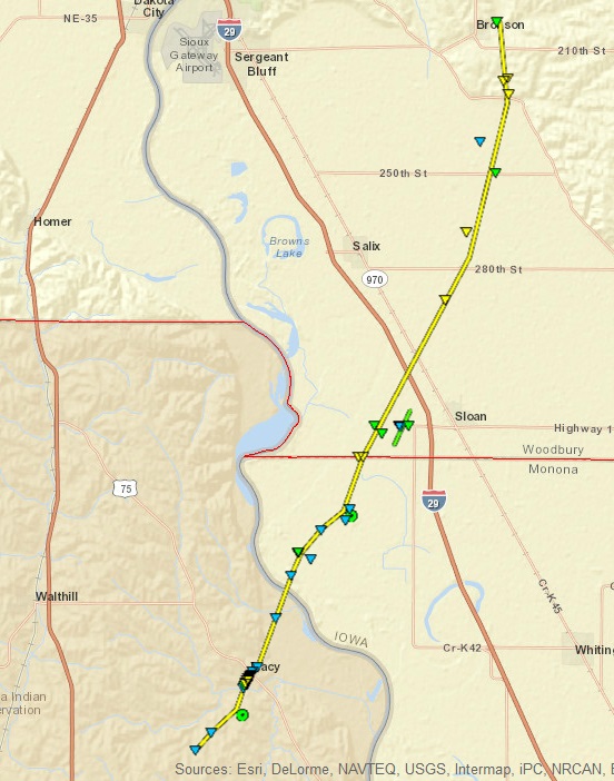
This EF-2 continued northeastward from Macy, NE, where the two injuries occurred. The tornado destroyed buildings two miles southeast of Salix, IA and severely damaged open-air buildings at a dairy operation three miles east of Salix. Other homes & buildings were destroyed or severely damaged by 130 mph winds approximately one and a half miles southeast of Bronson, IA, before the tornado weakened and dissipated one mile east of Bronson.
Map of Macy, NE tornado track

Click on map to download a kmz file that will display this path in Google Earth. If you download the kmz file and import it into Google Earth, each triangle will link to a description of the damage that was observed and may also include photos.
Radar images of the tornadic supercell as it moves across western Woodbury County
|
Radar picture from 6:20 pm CDT, October 4, 2013. The tornado has just crossed from Monona County, IA into Woodbury County, IA west of Sloan, IA. |
|
This radar picture is from 6:32 pm CDT, October 4, 2013. The tornado is now southeast of Bronson, Iowa, where it will damage several homes and farms. At this point, the tornado is beginning to occlude, which means it is being cut off from the warm and moist air that helps maintain the tornado. Nonetheless, this tornado will remain at EF-2 strength for another 15 minutes before dissipating. A new tornado is beginning to form to the southeast and will become the Pierson, IA tornado. |
Click on the radar images for a larger version of the radar picture.
Photos of tornado damage associated with the Macy, Nebraska tornado in Woodbury County
|
Photo of a snapped power pole 2 miles west of Sloan, Iowa along the Monona and Woodbury County line. Winds were estimated at 118 mph and the tornado was rated at EF-2 at this point. |
Photo of severely damaged dairy buildings 4 miles east of Salix, Iowa. Winds were estimated at 116 mph and the tornado was rated EF-2 at this point. Photograph courtesy of Gary Brown, Emergency Manager for Woodbury County, IA. |
Click on images for enlarged versions of any photo.
| EF Scale Rating | EF-1 |
| Estimated Peak Wind | 90 mph |
| Path Length in statute miles | 1.16 |
| Maximum Path Width | 100 yard |
| Fatalities | 0 |
| Injuries | 0 |
| State Date | October 4, 2013 |
| Start Time | 6:17 pm CDT |
| Start Location | 2 miles southwest of Sloan, Woodbury County, Iowa |
| Lat/Lon | 42.221oN 96.263oW |
| End Date | October 4, 2013 |
| End Time | 6:20 pm CDT |
| End Location | 1 mile northwest of Sloan, Woodbury County, Iowa |
| Lat/Lon | 42.236oN 96.254oW |
This brief EF-1 tornado caused tree damage and minor damage to farm outbuildings before dissipating northwest of Sloan, IA.
| Map of tornado path near Sloan, Iowa | Photo of tornado damage near Sloan, IA |
|
Photo of damage to trees and some farm buildings 1.5 miles west of Sloan Iowa. The winds were estimated at 90 mph and the tornado was rated EF-1 at this point. |
Click on either image for an enlarged version of the map or photo. A kmz file is also available to download into Google Earth. If you download the kmz file and import it into Google Earth, each triangle will link to a description of the damage that was observed and may also include photos. This kmz file contains information for both this Sloan, Iowa, tornado and the Macy, Nebraska tornado discussed above.
| EF Scale Rating | EF-1 |
| Estimated Peak Wind | 110 mph |
| Path Length in statute miles | 5.9 |
| Maximum Path Width | 400 yard |
| Fatalities | 0 |
| Injuries | 0 |
| State Date | October 4, 2013 |
| Start Time | 6:25 pm CDT |
| Start Location | 2 miles north-northwest of Jackson, Dakota County, Nebraska |
| Lat/Lon | 42.492oN 96.590oW |
| End Date | October 4, 2013 |
| End Time | 6:35 pm CDT |
| End Location | 3 miles southeast of Jefferson, Union County, South Dakota |
| Lat/Lon | 42.567oN 96.254oW |
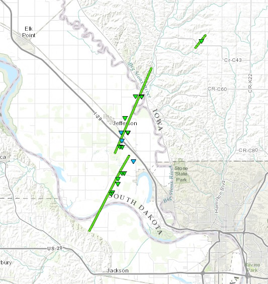
This tornado resulted in damage to homes and was responsible for extensive tree damage in a subdivision west of McCook Lake, which is approximately five miles south-southwest of the town of Jefferson, SD.
Map of the Jackson, NE, Jefferson, SD and rural Plymouth County tornadoes

Click on map to download a kmz file that will display this path in Google Earth. If you download the kmz file and import it into Google Earth, each triangle will link to a description of the damage that was observed and may also include photos.
Radar images of the tornadic supercell as it moves into southern Union County
|
Radar image from 6:24 pm CDT of the supercell producing the Jackson, NE tornado just after it has crossed the Missouri River into South Dakota. Click on the picture for a larger version of this image. |
Photos of tornado damage west of McCook Lake, South Dakota
|
Photo of a garage destroyed and roof significantly damaged by the tornado just after it crossed the Missouri River and moved into a development 2 miles west of McCook Lake, SD. Winds were estimated at 110 mph and the tornado was rated EF-1 at this point. |
Photo of a garage damaged and tree snapped at its base approximately 1 mile west-northwest of McCook Lake, SD. Winds were estimated at 100 mph and the tornado was rated EF-1 at this point. |
| EF Scale Rating | EF-1 |
| Estimated Peak Wind | 107 mph |
| Path Length in statute miles | 6.42 |
| Maximum Path Width | 800 yard |
| Fatalities | 0 |
| Injuries | 0 |
| State Date | October 4, 2013 |
| Start Time | 6:35 pm CDT |
| Start Location | 2.5 miles south of Jefferson, Union County, South Dakota |
| Lat/Lon | 42.570oN 96.555oW |
| End Date | October 4, 2013 |
| End Time | 6:45 pm CDT |
| End Location | 5 miles northeast of Jefferson, Union County, South Dakota |
| Lat/Lon | 42.656oN 96.505oW |
This tornado resulted in damage to farm outbuildings and homes, while also causing widespread tree and crop damage. Buildings at a cattle operation were also damaged along Interstate 29, approximately two miles south of Jefferson, SD before the tornado crossed the Interstate.
Radar images of the tornadic supercell as it moves across southern Union County
|
Radar image from 6:37 pm CDT of the tornado-producing supercell near Jefferson, SD. |
Photos of tornado damage east of Jefferson, South Dakota
|
Photo of damage to farm buidings 1 mile southeast of Jefferson, South Dakota. In addition to the building damage, numerous trees and branches were brought down and corn was flattened in fields to the northeast of this farmstead. Winds were estimated at 107 mph and the tornado was rated EF-1 at this point. |
Photo of a grainbin which was blown into the side of a house approximately 2 miles northeast of Jefferson, South Dakota, near the Iowa border. In addition, numerous large branches were down. Winds were estimated around 90 mph and the tornado was rated EF-1 at this point. |
| EF Scale Rating | EF-1 |
| Estimated Peak Wind | 105 mph |
| Path Length in statute miles | 1.12 |
| Maximum Path Width | 100 yard |
| Fatalities | 0 |
| Injuries | 0 |
| State Date | October 4, 2013 |
| Start Time | 6:50 pm CDT |
| Start Location | 8 miles northeast of Jefferson, Union County, South Dakota |
| Lat/Lon | 42.676oN 96.445oW |
| End Date | October 4, 2013 |
| End Time | 6:52 pm CDT |
| End Location | 8 miles northwest of Hinton, Plymouth County, Iowa |
| Lat/Lon | 42.688oN 96.432oW |
This brief EF-1 tornado caused damage to farm buildings and trees in the grove surrounding the farmstead.
Radar images of the tornadic supercell over southwestern Plymouth County
|
Radar image of the tornadic supercell in southwestern Plymouth County, IA at 6:50 pm CDT. |
Click on the image for a larger version of this image.
Photo of tornado damage in southwestern Plymouth County, Iowa
|
This is a photo of damage to a farm in southwestern Plymouth County - approximately 8 miles northwest of Hinton, Iowa. Numerous trees were snapped approximately 4-6 feet above the ground. There was also damage to some outbuildings, and a tree falling on the house caused damage to the roof. |
| EF Scale Rating | EF-1 |
| Estimated Peak Wind | 100 mph |
| Path Length in statute miles | 5.45 |
| Maximum Path Width | 200 yards |
| Fatalities | 0 |
| Injuries | 0 |
| State Date | October 4, 2013 |
| Start Time | 8:32 pm CDT |
| Start Location | 5 miles south-southwest of Alta, Buena Vista County, Iowa |
| Lat/Lon | 42.603oN 95.365oW |
| End Date | October 4, 2013 |
| End Time | 8:42 pm CDT |
| End Location | Alta, Buena Vista County, Iowa |
| Lat/Lon | 42.664oN 95.297oW |
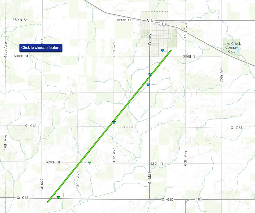
Maps of the Alta, IA tornado tracks

Click on map to download a kmz file that will display this path in Google Earth. If you download the kmz file and import it into Google Earth, each triangle will link to a description of the damage that was observed and may also include photos.
Radar images of the tornadic supercell near Alta, Iowa
|
This is a radar image of the tornadic storm near Alta Iowa at 8:37 pm CDT. Unlike the other storms shown above, this storm does not have a hook echo associated with it. |
Click on the image for a larger version of this image.
Photos of tornado damage near Alta, Iowa
|
This is a photo of a destroyed garage. The damage occurred 5 miles southwest of Alta, Iowa. As the garage gave way, portions of the roof also lifted over the portion of the house adjacent to the garage. Several large branches and a couple of trees were down in the area as well. The winds were estimated around 100 mph and the tornado was rated EF-1 at this point. |
This is a photo of bleachers from a nearby baseball complex that were thrown into trees to the north of the baseball diamond. The bleachers were thrown over 100 yards. In addition to this damage, there was also damage to the roof of the Alta High School and numerous trees were damaged in the vicinity. The winds were estimated around 80 mph and the tornado was rated EF-0 at this point. |
EF Scale: The Enhanced Fujita tornado scale classifies tornadoes into the following categories:
EF0...wind speeds 65 to 85 mph.
EF1...wind speeds 86 to 110 mph.
EF2...wind speeds 111 to 135 mph.
EF3...wind speeds 136 to 165 mph.
EF4...wind speeds 166 to 200 mph.
EF5...wind speeds greater than 200 mph.
Note: Information in this statement is preliminary and subject to change pending final review of the event and publication in NWS Storm Data.