National Weather Service United States Department of Commerce

Storm Impacting the Northwest U.S.; Fire Weather Conditions in Southern California; Severe Weather in the South

A Pacific storm is bringing areas of low elevation rain, moderate to heavy mountain snow, and high winds to the Northwest. Strong Santa Ana winds and very dry conditions are producing elevated to critical fire weather conditions in southern California. Isolated strong to severe thunderstorms are possible through early Wednesday morning across parts of northeast Texas into western Tennessee. Read More >


Map of 24 hour estimated rainfall amounts through 7 AM Sunday, May 6, 2012

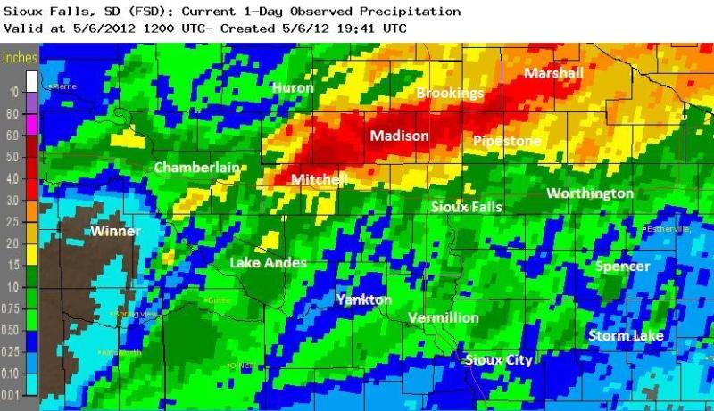
24 HOUR PRECIPITATION DATA IN INCHES...FOR SOUTHEAST SOUTH DAKOTA...
SOUTHWEST MINNESOTA...NORTHWEST IOWA...AND NORTHEAST NEBRASKA
...RECEIVED BY 9 AM SUNDAY MAY 6 2012.


...SOUTHEAST SOUTH DAKOTA...

  5 W MADISON                               6.22
  9 N FULTON                                5.58
  WINFRED                                   5.30
  5 W HOWARD                                4.28
  3 SSW BROOKINGS                           3.45
  10 NNE HOWARD                             3.35
  1 S BROOKINGS                             3.33
  MITCHELL                                  3.17
  BROOKINGS COOP                            2.47
  ASTORIA                                   1.70
  OAK LAKE                                  1.62
  WHITE LAKE                                1.15
  DELL RAPIDS                               0.99
  BROOKINGS AIRPORT                         0.79
  SIOUX FALLS AIRPORT                       0.76
  PICKSTOWN                                 0.75
  HURON COOP                                0.44
  HURON AIRPORT                             0.43
  WESSINGTON SPRINGS                        0.40
  CENTERVILLE                               0.36
  WESSINGTON RAWS                           0.34
  CHAMBERLAIN                               0.27
  VERMILLION                                0.20
  YANKTON COOP                              0.17


...SOUTHWEST MINNESOTA...

  PIPESTONE                                 2.94
  MARSHALL AIRPORT                          2.79
  MARSHALL COOP                             2.78
  TRACY AIRPORT                             2.66
  SLAYTON                                   1.86
  WINDOM AIRPORT                            1.40
  WORTHINGTON COOP                          1.16
  JACKSON AIRPORT                           1.16
  LAKEFIELD                                 0.82
  LUVERNE AIRPORT                           0.61
  WORTHINGTON AIRPORT                       0.37


...NORTHWEST IOWA...

  LAKE PARK                                 0.81
  SIBLEY                                    0.71
  SHELDON                                   0.68
  ORANGE CITY                               0.54
  SPENCER AIRPORT                           0.51
  ORANGE CITY                               0.51
  LE MARS                                   0.46
  REMSEN COOP                               0.45
  BATTLE CREEK 3NE                          0.29
  CHEROKEE                                  0.26
  STORM LAKE                                0.26
  SIOUX CITY                                0.24

.END...