Sioux Falls, SD
Weather Forecast Office
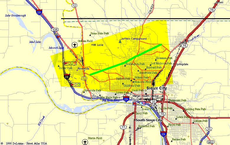
A downburst caused significant damage to portions of Sioux City, Iowa on 2 August 2001. The damage was primarily across the northern portion of the city - from North Sioux City and the Riverside area to the Plymouth County line. The worst damage extended for 3 or 4 miles and was 2 or 3 blocks wide. Wind damage continued to the east of Sioux City affecting the Hinton area as well as Kingsley Iowa. The strongest wind report was 98 mph in Sioux City with numerous 60-70 mph (with trees down) into eastern Woodbury and southeastern Plymouth County.
Below is a map of the area of widespread damage in the Sioux City metropolitan area. The yellow highlighted area is the area where numerous trees and some structural damage was reported. The light green line is the approximate area where the worst wind damage occurred.
Popular Pages
Past Weather Events
Regional Weather Roundup
Daily Temp/Precip
Hazardous Weather
Local Climate Archives
Climate Graphs and Data
Seasonal
EvapoTranspiration
Fire Weather
Grassland Fire Danger
Flooding (River)
Summer Weather
Travel Forecasts
Winter Weather
Winter Preparedness
Forecast Snowfall Graphic
Winter Temp Climatology
US Dept of Commerce
National Oceanic and Atmospheric Administration
National Weather Service
Sioux Falls, SD
26 Weather Lane
Sioux Falls, SD 57104-0198
605-330-4247
Comments? Questions? Please Contact Us.


 Weather Story
 Weather Map
 Local Radar