Gusty winds and dry conditions will continue to bring elevated to critical fire weather conditions to the southern Plains and Southeast early this week. A Pacific storm system will bring low elevation rain and heavy high elevation mountain snow to northern and central California through early week, expanding into the Pacific Northwest, Great Basin, and southern California on Tuesday. Read More >
Wind Chill is a term used to describe what the air temperature feels like to the human skin due to the combination of cold temperatures and winds blowing on exposed skin. In simple terms, the colder the air temperature and the higher the wind speeds the colder it will feel on your skin if you're outside. So even if it remains the same temperature, but the wind speed increases it will actually feel colder to your skin.
So why does it feel colder if the wind speed increases but the temperature remains the same? The reason is because as wind blows across our bodies it takes the heat we naturally emit and blows it away from our bodies. The faster the wind speed the faster our body heat is taken away and the colder it feels. It is a similar process for when you blow on a hot bowl of soup to cool it down. The temperature that it feels like outside due to the air temperature and wind speed is called the "Wind Chill."
Below is a chart that shows the wind chill for various air temperatures and wind speeds. The colors represent a frostbite indicator, showing the points where temperature, wind speed and exposure time will produce frostbite on humans. Each shaded area shows how long a person can be exposed before frostbite develops. For example, a temperature of 0°F and a wind speed of 15 mph will produce a wind chill temperature of -19°F. Under these conditions, exposed skin can freeze in 30 minutes.
Our Winter Weather Page has a wind chill calculator among other extremely useful winter weather information.
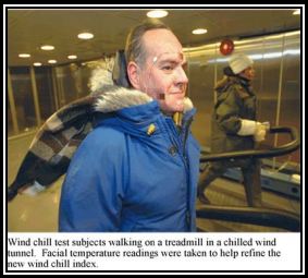
The NWS Wind Chill Temperature index uses advances in science, technology, and computer modeling to provide an accurate, understandable, and useful formula for calculating the dangers from winter winds and freezing temperatures. In early summer of 2001, Human trials were conducted at the Defense and Civil Institute of Environmental Medicine in Toronto, Canada. The trial results were used to improve the accuracy of the new formula and determine frostbite threshold values. During the human trials, twelve volunteers (six men and six women) were placed in a chilled wind tunnel and thermal transducers were stuck to their faces to measure heat flow from the cheeks, forehead, nose and chin while walking 3 mph on a treadmill. Each Volunteer participated in four trials of 90 minutes each and was exposed to varying wind speeds and temperatures. The new wind chill index is now being used in Canada and the United States.
|
Properties of the Wind Chill Temperature index: -Calculates wind speed at an average height of five feet
-Is based on a human face model
-Incorporates modern heat transfer theory -Lowers the calm wind threshold from 4 mph to 3 mph -Uses a consistent standard for skin tissue resistance -Assumes no impact from the sun (i.e. clear night sky). |
 |