|
|
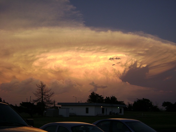
Have you ever looked at the sky on a May or June day and seen a very tall storm cloud that has an anvil that stretches as far east as you can see? If so, chances are you have probably seen a supercell thunderstorm (Figure 1). On the thunderstorm spectrum, supercells are the least common type of thunderstorm, but they have a high propensity to produce severe weather, including damaging winds, very large hail, and sometimes weak to violent tornadoes. What makes a supercell unique from all other thunderstorm types is that it contains a deep and persistent rotating updraft called a mesocyclone. If the environment is favorable, supercell thunderstorms can last for several hours.
|

Figure 1. Supercell near Groom, TX on June 18, 2010 viewed from the NWS Amarillo office. Courtesy of Chris Nuttall. |
|
What ingredients are needed for the development of supercells? Although supercells require some degree of buoyancy, moderate to strong speed and directional wind shear between the surface and about 20,000 feet is the most critical factor. Wind shear not only creates the mesocyclone, but it also allows the storm to be tilted, which is important for maintaining a separate updraft and downdraft region. A separate updraft and downdraft allows the supercell to be long-lived because it reduces the likelihood that too much rain-cooled, stable air from the downdraft region will be ingested into the updraft, causing the storm to weaken.
|
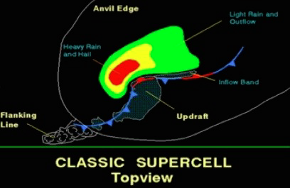
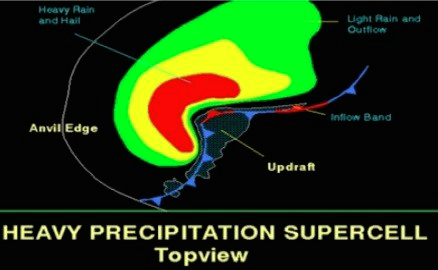
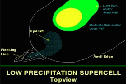
| Supercells are most common in the central part of the United States, but they can occur in other regions of the country and other parts of the world. There are also a variety of supercell types, including classic, high precipitation, low precipitation, and even miniature. Classic supercells (Figure 2) are tough to precisely define. Nonetheless, these supercells typically exhibit a textbook appearance on radar and in the field for spotters. Radar features may include the presence of a hook echo, a weak echo region (WER), a bounded weak echo region (BWER), and a V-notch. Low-level storm features are visually identified by a well-defined wall cloud, a rain free base, a rear flank downdraft, and distinctly separate updraft and downdraft regions. Classic supercells are most com-monly found in the Great Plains of the United States and can be relatively isolated. High precipitation (HP) supercells (Figure 3) are less isolated than their classic counterparts and often form in environments with a high degree of atmospheric moisture and weak mid-level storm-relative winds. As a result, the updraft tends to become rain-wrapped, which makes it difficult to identify low-level storm features, including wall clouds and tornadoes. Low precipitation (LP) supercells (Figure 4) form in environments with low atmospheric moisture content and strong mid-level storm-relative winds. LP supercells usually don’t produce much precipitation, but what precipitation they do produce is usually in the form of very large hail. Since these supercells form in an environment with low atmospheric moisture, they are not uncommon in the Texas and Oklahoma Panhandles. Miniature supercells are smaller versions of classic supercells, they typically form in the cool season, and they are characterized by weak to moderate buoyancy that is confined to a relatively small vertical depth below 20,000 feet above ground level. |
 |
 |
 |
| Figure 2. Top view and radar depiction of a classic supercell. |
Figure 3. Top view and radar depiction of a high precipitation supercell. |
Figure 4. Top view and radar depiction of a low precipitation supercell. |
|
| It can be difficult to characterize the type of a supercell because it will likely evolve from one type to another during its life cycle. For example, a supercell may initially form as a LP supercell on the Caprock, but by the time it moves off the Caprock, it may transition to a classic supercell. Regardless of the supercell types, the processes responsible for supercell formation are the same for every location. |
|
