
Tropical Depression Two is expected to gradually strengthen and could bring tropical storm conditions to the Florida Panhandle beginning late Monday. Areas of flash flooding will be possible through Thursday along the eastern and central Gulf Coast. Severe thunderstorms will develop and move along a cold front crossing the Upper Midwest Monday, and through the Ohio Valley/Mid-Atlantic on Tuesday. Read More >
Overview
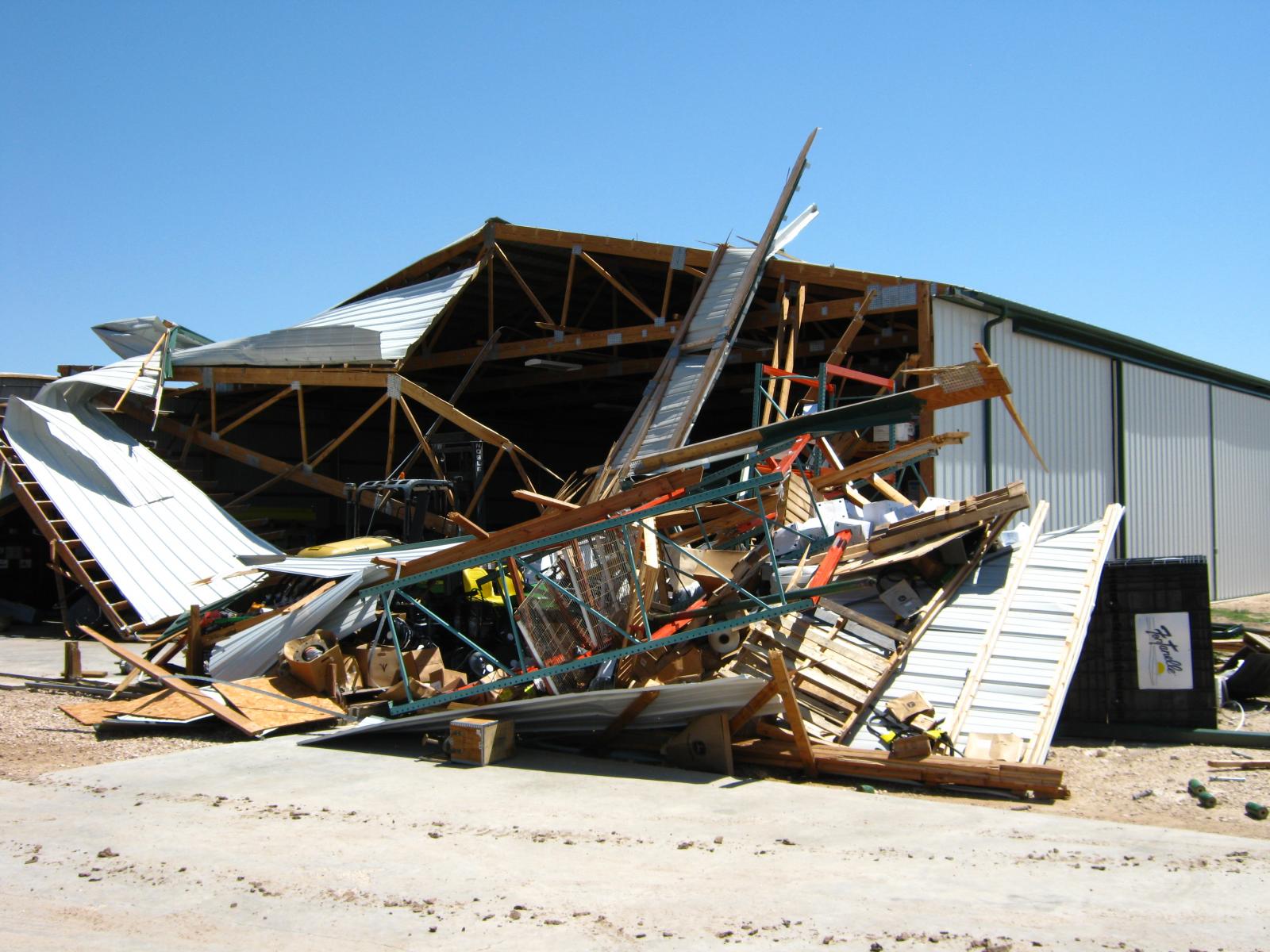
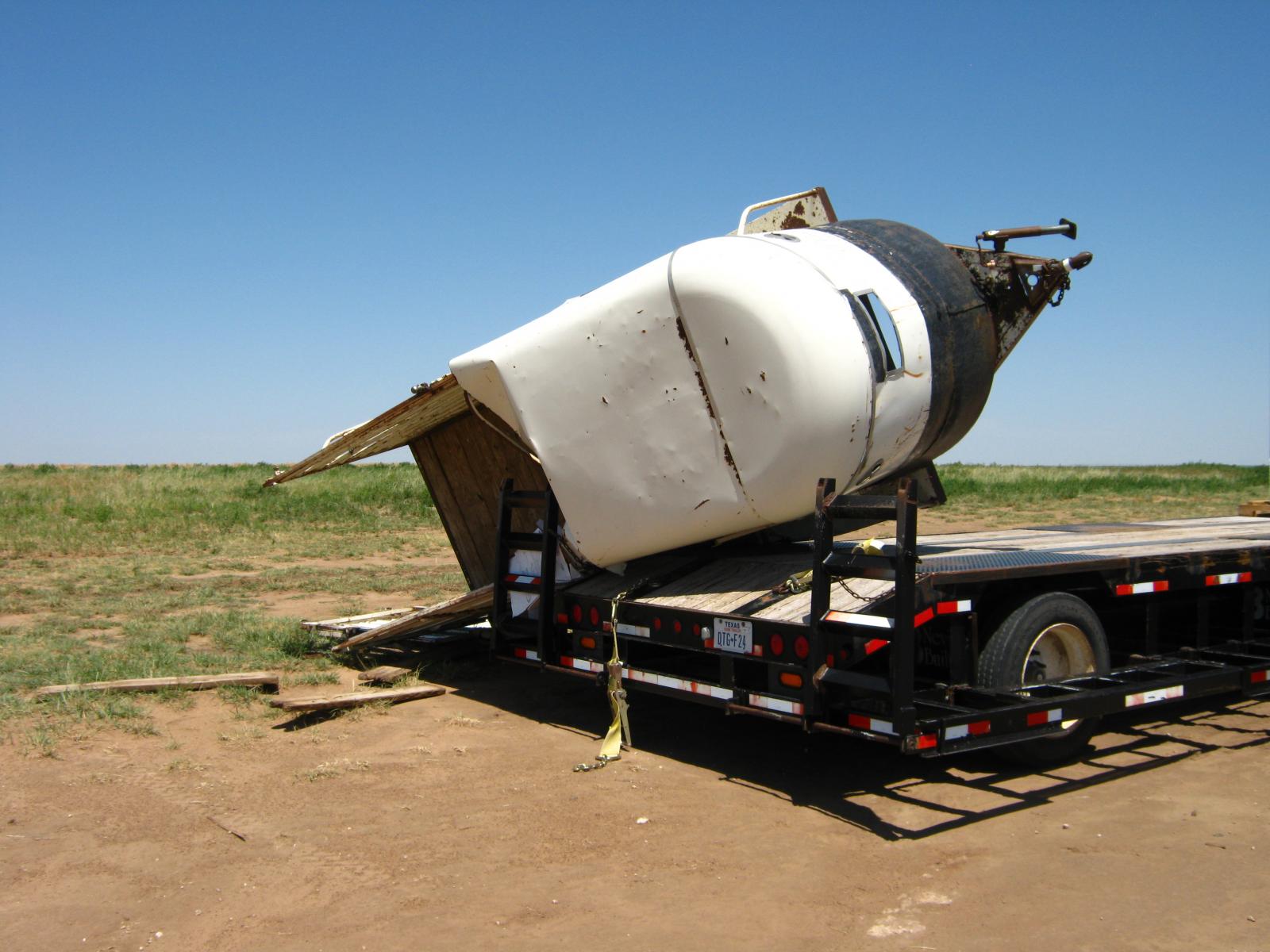
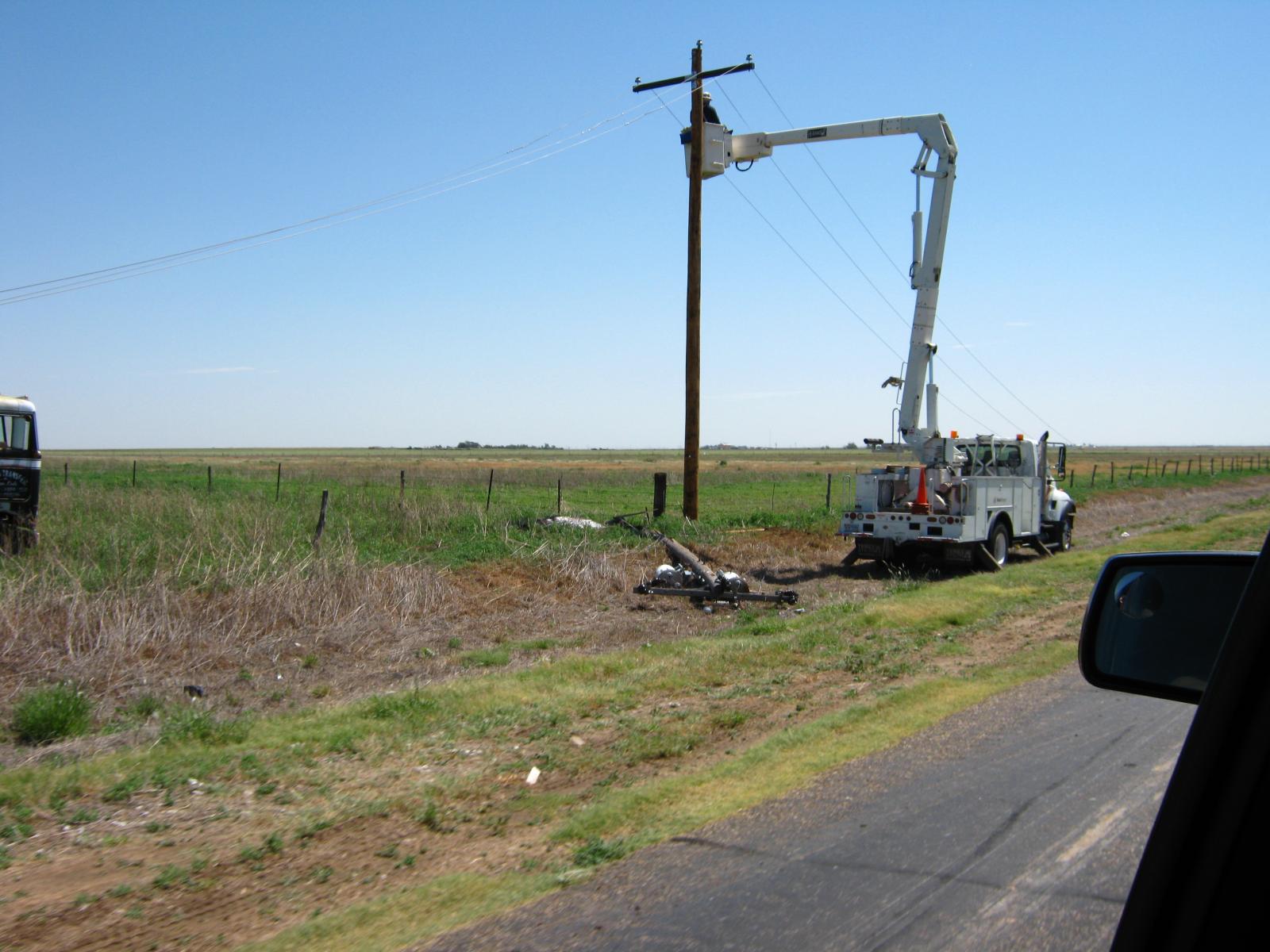
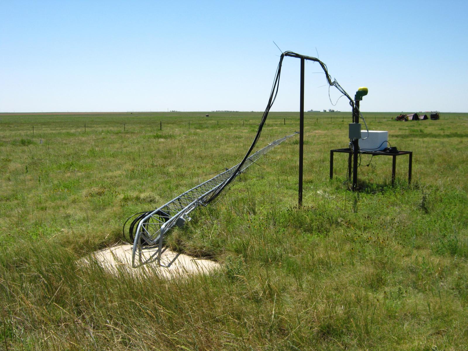
An embedded shortwave within the upper flow sparked off scattered showers and thunderstorms across the Oklahoma and Texas Panhandles during the evening and overnight hours of June 20th, 2017. A supercell thunderstorm moving southward across Sherman County produced two microbursts as it neared the southern portion of the county. The first microburst produced damage consistent with 118 mph winds. Some of this damage was two walls knocked out of a well built warehouse, bent over radio tower, and a flipped horse trailer. The second microburst occurred approximately 4 miles south-southeast of the first. This one resulted in wind gusts of 85 mph. This microburst snapped 12 to 13 telephone poles along FM1573. As this supercell moved into northern Moore County it also produced nickel size hail.
Wind Damage Photos:
 |
 |
 |
 |
| Storm Survey: Destroyed Warehouse at Spurlock Farms | Storm Survey: Flipped horse trailer at Spurlock Farms | Storm Survey: Damage telephone pole along FM1573 | Storm Survey: Bent radio tower at Spurlock Farms |
Radar:
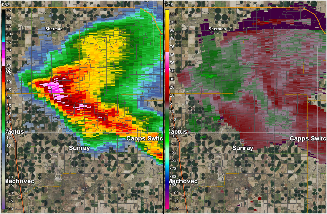 |
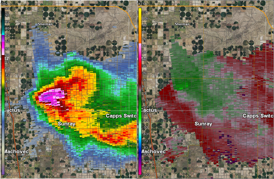 |
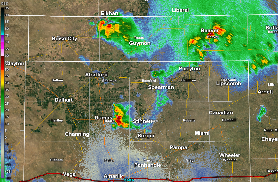 |
| Radar image of first microburst north of FM1573 | Radar image of second microburst south of FM1573 | Radar image as the supercell which caused the microburst moved over central Moore County |
Storm Reports:
PRELIMINARY LOCAL STORM REPORT...SUMMARY
NATIONAL WEATHER SERVICE AMARILLO TX
1132 PM CDT THU JUN 22 2017

..TIME...   ...EVENT...      ...CITY LOCATION...     ...LAT.LON...
..DATE...   ....MAG....      ..COUNTY LOCATION..ST.. ...SOURCE....
            ..REMARKS..

0850 PM     TSTM WND DMG     12 NE CACTUS            36.18N 101.89W
06/20/2017                   SHERMAN            TX   NWS STORM SURVEY

            A MICROBURST ASSOCIATED WITH A SEVERE THUNDERSTORM
            CAUSED STRUCTURAL DAMAGE TO A WELL-BUILT
            WAREHOUSE...SHEDS...A RADIO TOWER...AND IRRIGATION
            FARMING EQUIPMENT. THE WORST DAMAGE OBSERVED WAS TO A
            WELL-BUILT WAREHOUSE WITH COMPLETE WALL FAILURE AND A
            100 FOOT RADIO TOWER BENT TO A 90 DEGREE ANGLE STARTING
            NEAR THE BASE. THE DAMAGE PATH ASSOCIATED WITH THE
            MICROBURST HAD A PATH LENGTH OF 2.1 MILES....A MAXIMUM
            WIDTH OF 2.3 MILES...AND ENDED AROUND 851 PM CDT.

0900 PM     TSTM WND DMG     10 NW SUNRAY            36.12N 101.95W
06/20/2017                   SHERMAN            TX   PUBLIC

            PATIO ROOF WAS BLOWN OFF AND ALSO RIPPED THE METAL ROOF
            OFF PART OF THE HOUSE.

0903 PM     TSTM WND DMG     16 SSE STRATFORD        36.12N 101.96W
06/20/2017                   SHERMAN            TX   LAW ENFORCEMENT

            5 TO 6 POWER POLES BLOWN OVER ONTO F.M. ROAD 1573 7
            MILES EAST OF U.S. HIGHWAY 287.

0911 PM     TSTM WND DMG     8 NW SUNRAY             36.10N 101.92W
06/20/2017                   SHERMAN            TX   NWS STORM SURVEY

            A MICROBURST ASSOCIATED WITH A SEVERE THUNDERSTORM
            DAMAGED CENTER PIVOTS OF IRRIGATION EQUIPMENT AND
            SNAPPED 13 POWERPOLES. THE DAMAGE PATH ASSOCIATED WITH
            THE MICROBURST HAD A PATH LENGTH OF 2.3 MILES...A PATH
            WIDTH OF 2.1 MILES...AND ENDED AROUND 912 PM CDT.

0928 PM     HAIL             4 W SUNRAY              36.02N 101.89W
06/20/2017  E0.88 INCH       MOORE              TX   FIRE DEPT/RESCUE
Survey Results:
Public Information Statement
National Weather Service Amarillo TX
437 PM CDT Wed Jun 21 2017

...NWS Damage Survey for June 20th 2017 Microburst Thunderstorm Event...

.Microburst #1 11 miles NE Cactus...

Peak Wind Estimated:    118 mph
Path Length /Statute/:  2.12 miles
Path Width /Maximum/:   2.34 miles
Fatalities:             0
Injuries:               0

Start Date:             Jun 20 2017
Start Time:             8:50 PM CDT
Start Location:         11 miles northeast of Cactus
Start Lat/Lon:          36.18 / -101.89

End Date:               Jun 20 2017
End Time:               8:51 PM CDT
End Location:           10 miles north-northwest Sunray
End Lat/Lion:           36.16 / -101.87

.Microburst #2 8 miles northwest Sunray...

Peak Wind Estimated:    85 mph
Path Length /Statute/:  2.3 miles
Path Width /Maximum/:   2.1 miles
Fatalities:             0
Injuries:               0

Start Date:             Jun 20 2017
Start Time:             9:11 PM CDT
Start Location:         8 miles northwest Sunray
Start Lat/Lon:          36.11 / -101.90

End Date:               Jun 20 2017
End Time:               9:12 PM CDT
End Location:           10 North-northwest Sunray
End Lat/Lion:           36.15 / -101.88

A supercell thunderstorm moved southward across Sherman County
during the evening hours of June 20th. As the supercell neared the
southern end of the county it produced two microbursts. The first
microburst was approximately 2.5 miles north-northwest of the
intersection of FM 1573 and County Road 17 at 8:50 PM CDT. The
second microburst occurred roughly at 9:11 PM CDT 2.75 miles
south-southwest of the intersection of County road 17 and FM 1573.
Damage associated with the first microburst included: a west
facing wall and attached ceiling section were knocked down on a
well build warehouse at Spurlock Farms, smaller nearby sheds had
parts or the entire roof blown off, a 100ft radio tower was bent
90 degrees at the ground, and center pivot points of irrigation
systems had been tipped over. Damage associated with the second
microburst were, center pivot points of irrigation systems had
been tipped on their side and 12 to 13 power poles snapped at
their base. The storm would continue south southeast into Moore
County.

NOTE:
The information in this statement is preliminary and subject to
change pending final review of the event and publication in
NWS storm data.
 |
Media use of NWS Web News Stories is encouraged! Please acknowledge the NWS as the source of any news information accessed from this site. |
|

