Gusty winds and dry conditions will continue to bring elevated to critical fire weather conditions to the southern Plains and Southeast early this week. A Pacific storm system will bring low elevation rain and heavy high elevation mountain snow to northern and central California through early week, expanding into the Pacific Northwest, Great Basin, and southern California on Tuesday. Read More >
Overview
A new forecast zone is coming to the Texas Panhandle.
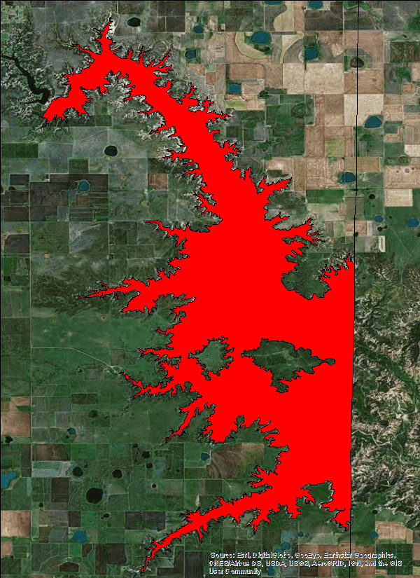
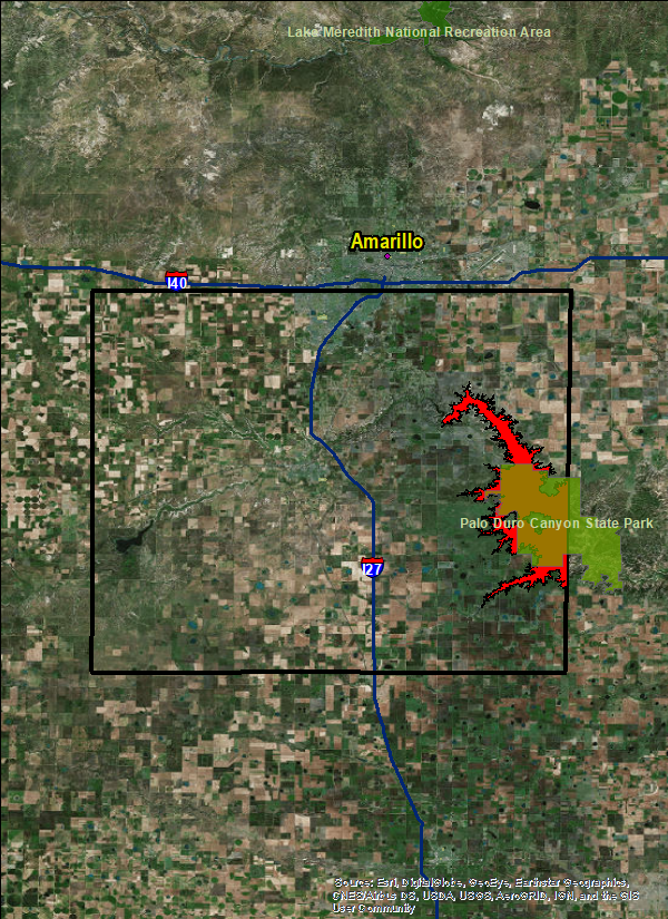
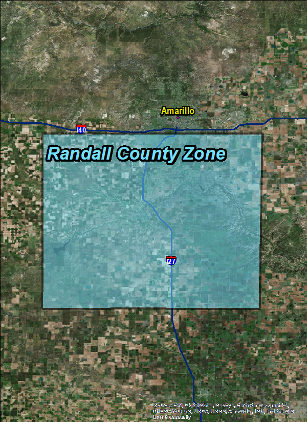
The creation of a Palo Duro Canyon zone (left side image below) will provide specialized heat advisories/warnings for recreational interests in the Canyon during the hot summer months. These specialized forecasts are intended to improve public awareness of extreme temperatures in the Canyon between “rim” where the public enters and the “floor” of the canyon where much of the recreational activities take place. In addition, the Canyon will often reach extreme temperatures that warrant a heat advisory for all of Randall County even though the rest of the county will not reach heat advisory or excessive heat warning. This proposed zone is intended to bring special attention to the Canyon in protection of tourist lives doing activities within it and the property of those that may be impacted by extreme heat. Furthermore, the new proposed zone will help avoid unwarranted advisories/warnings for the remainder of Randall County (right side image below). It should be noted that although a portion of Palo Duro Canyon extends outside of Randall County into Armstrong County, NWS Amarillo is not proposing a change to that portion of the zone at this time due to the fact it is not open to the public.
| New Forecast Zone for Palo Duro Canyon | New Zone Compared to Randall County (outlined in black) |
 |
 |
Overview
The National Weather Service office in Amarillo Texas has a County Warning Area that includes Palo Duro Canyon, which is the second largest canyon system in the United States. Annually, the Palo Duro Canyon State park will have 300,000 guests, making it the most visited outdoor and nature attraction on the southern High Plains. The park, and the canyon system in which it sits, is commonly subject to extreme and dangerous weather, such as flash floods and other thunderstorm-related hazards. The most prolific threat to the lives of visitors at Palo Duro Canyon State Park; however, is extreme heat. A majority of the park’s annual visitation occurs during the hot summer months, which is the most common period where temperatures can vary drastically from the Canyon rim to the Canyon floor.
Park visitors, many of whom are visiting tourists unfamiliar with west Texas climate, are frequently subjected to extreme heat while participating in physical outdoor activities. During multi-day heat waves which occur each summer in Palo Duro Canyon, temperatures can rise to an estimated 120° F due to Palo Duro Canyon’s microclimate. These extreme temperatures are significantly hotter than measured conditions on the canyon rim and the rest of the county. This results in Palo Duro Canyon having significantly different weather and climate conditions than the rest of the county in which the canyon sits. The current zone which encompasses the entire county, including the canyon, misrepresents the different climate conditions in the county. A recent study showed between 2011 and 2014, 106 heat-related illnesses and/or deaths were reported in Palo Duro Canyon State Park. In 2014 43% of summer days where the temperature was greater than or equal to 100°on the Canyon Floor versus only 4% on the Plains. A total of 75% of historic heat-related incidents have occurred when the canyon floor temperatures are greater than or equal to 105°.
Service Change Notification:
Official Notification
To: Subscribers:
-NOAA Weather Wire Service
-Emergency Managers Weather Information Network
-NOAAPORT
-Other NWS Partners and NWS Employees
From: Michelle Hawkins, Chief
Severe, Fire, Public and Winter Weather Services Branch
Subject: Changes in Fire and Public Zones for NWS Weather Forecast Office Amarillo, Texas, Randall County, effective May 1st, 2018.
Effective Tuesday May, 1st, 2018 at 100 PM CDT, 1800 Coordinated Universal Time (UTC), Randall County, Texas, existing public and fire weather forecast zones for Weather Forecast Office (WFO) Amarillo (AMA), TX, will be divided into a new Palo Duro Canyon zone and a Randall County zone.
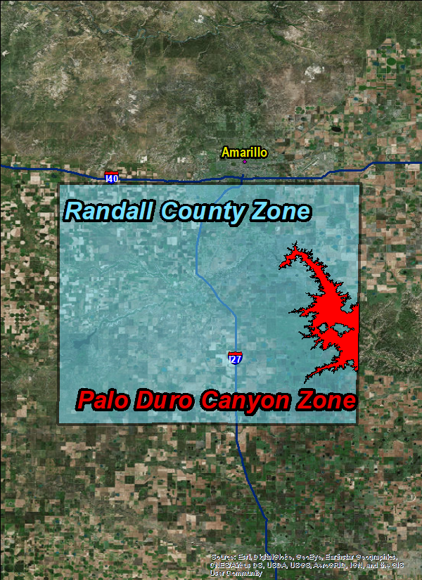
Specifically, the split will be along the rim of the canyon and will encompass the Palo Duro Canyon within Randall County, Texas. These changes are intended to provide increased flexibility and improved accuracy of forecast for various watches, warnings, and advisories in the public and fire weather programs. The current zone is shown below in Table 1. This zone will be split into two zones shown in Table 2.
The Fire and Public Zone changes require partners and users to take appropriate action to receive the new zone products using the Universal Generic Code (UGC) zone code format (Z) listed in Table 2.
Table 1: Current affected WFO AMA Public and Fire Weather Forecast Zones
Current Fire/Public Current UGC (Z)
Zone Name
-------------------- ---------------
Randall County TXZ017
Table 2: New WFO AMA affected Public and Fire Weather Forecast Zones
New Fire/Public New UGC (Z)
Zone Name
--------------- -----------
Palo Duro Canyon TXZ317
Randall County TXZ017
All public and fire weather products from WFO AMA that use the Zone (Z) Universal Geographic Code (UGC) are affected by these changes. Partners and users should take the appropriate action to ensure systems recognize the new UGC (Z) and new zone alignments and names. These changes do not affect products using county (C) UGC.
Updated public and fire zone maps are online at:
http://www.nws.noaa.gov/geodata/catalog/wsom/html/pubzone.htm
http://www.nws.noaa.gov/geodata/catalog/wsom/html/firezone.htm
Graphical depiction of WFO AMA’s current and new Fire and Public
Weather Forecast Zones are at the following website:
https://www.weather.gov/ama/NewPaloDuroCanyonForecastZone
For more information, please contact:
Mike Gittenger Melinda Bailey
NWS Amarillo NWS Southern Region Headquarters
Amarillo, Texas Fort Worth, TX 76102
806-335-1121 x223 904-741-4470 X223
NWS National Service Change Notices are online at:
http://www.weather.gov/os/notif.htm
Before and After:
| Randall County Zone (TXZ017) | Split Zones for both Randall County and Palo Duro Canyon Zone (TXZ317) |
 |
 |
 |
Media use of NWS Web News Stories is encouraged! Please acknowledge the NWS as the source of any news information accessed from this site. |
 |