
A Nor'easter will create hazardous marine and coastal conditions along the Mid-Atlantic coast through mid-week, with significant coastal flooding and beach erosion possible. Meanwhile, another strong storm system is forecast to bring high winds and heavy precipitation to portions of southern Alaska. Elsewhere, relatively benign weather is expected through the first half of the work week. Read More >
Overview
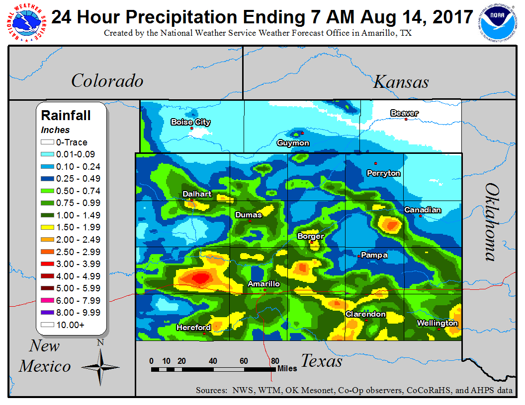
Wind shear increased in an unstable environment ahead of a short wave trough. Thunderstorms developed over northeast New Mexico and moved southeast. As they moved southeast they formed into and MCS which produced occasional severe wind gusts as it moved southeast across the Texas Panhandle. One of these occasions was a downburst event over Dalhart that produced 100-110 mph winds which caused lots of damage, particularly at the Dalhart Airport.Wind & Hail:
Add a written summary or simply an LSR map in this section. If writing an extensive report, you can break the report down into wind and hail below (otherwise delete).
Wind
Insert summary here.
| Caption | Caption | Caption | Caption |
Hail
Insert summary here.
| Caption | Caption | Caption | Caption |
Flooding
Add a written summary if needed.
Hydrographs
| Caption | Caption | Caption | Caption |
Radar/Photos
| Caption | Caption | Caption | Caption |
Photos & Video:
Header
| Caption (source) |
Caption (source) |
Caption (source) |
Caption (source) |
Storm Reports
Public Information Statement
National Weather Service Amarillo TX
421 PM CDT Mon Aug 14 2017

...NWS Damage Survey for 08/14/17 Dalhart Thunderstorm Wind
Event...

.Dalhart Downburst Wind Event...

Peak Wind Estimated:    100-110 mph
Fatalities:             0
Injuries:               0

Start Date:             Aug 13 2017
Start Time:             6:20 PM CDT
Start Location:         3 WSW Dalhart
Start Lat/Lon:          36.05, -102.56

End Date:               Aug 13 2017
End Time:               6:32 PM CDT
End Location:           2 SW Dalhart
End Lat/Lon:            36.03, -102.55

Summary: A significant downburst wind event occurred west and
southwest of Dalhart, TX on Sunday evening. The downburst was
associated with the rear flank downdraft of a supercell
thunderstorm. Damage from the downburst was initially observed
at the Twisted Elms Golf Course where several trees were
uprooted and many large branches were downed, including some
onto power lines. Damage at the golf course was estimated to
be caused by winds around 75 to 85 mph. The damage continued
to the southeast where several power poles were blown down.
Severe straight line wind damage peaked at the airport where a
74 mph wind was observed by NWS ASOS equipment before the
equipment was damaged by flying debris.  The debris was from
multiple airport hangars that were completely destroyed. Debris
from the hangars was found up to a half mile away. Several
small planes and a pop-up camper were flipped and thrown up to
50 yards. Damage at the airport was estimated to be from 100 to
110 mph winds, which is the equivalent of a high end EF-1
tornado.

NOTE:
The information in this statement is preliminary and subject to
change pending final review of the event and publication in
NWS storm data.
.
Rain Reports


 Follow us on X
 Follow us on Facebook
 AMA RSS Feed