Extremely critical fire weather concerns for portions of the southern High Plans as strong wind and very dry conditions could result in rapid spread of any fires. Meanwhile, severe thunderstorms are expected once again across areas of the Central and Southern Plains, then spreading in the Mississippi Valley regions on Monday. Damaging winds, very large hail and strong tornadoes are possible. Read More >
Western and Central Wyoming
Weather Forecast Office
Mountain snowpack and associated snow water equivalents (SWEs) across most of Wyoming were generally above average by the middle of March. SWEs at the peak snowmelt runoff elevations (8,500’ – 10,000’) were the highest across the Little Snake, Upper North Platte, and Laramie Basins at 120 to 130 percent of median. The Tongue Watershed had SWEs at 80 to near 90 percent of median at the peak snowmelt runoff elevations.
This outlook is based on various diverse hydrological factors such as snow water equivalents (SWEs) in the mountain snowpack, basin morphology (i.e. how basins respond to snowmelt runoff), antecedent soil moisture, biological/physical factors (bark beetle kill/spruce blight///fire burn scars), low elevation snow depths, and likely temperature and precipitation trends during late spring/early summer.
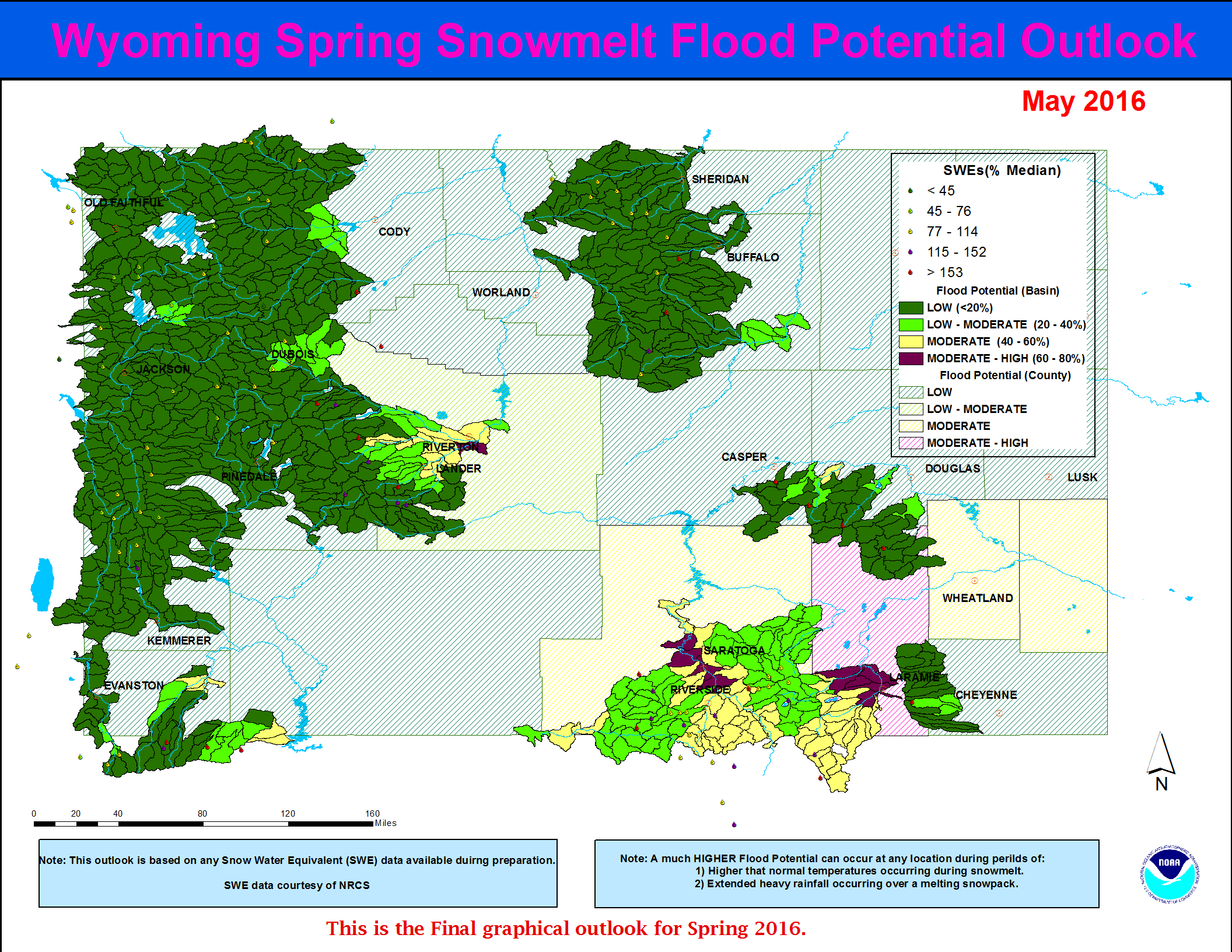
…Moderate potential for snowmelt runoff flooding is forecasted along the lower portions of the Upper North Platte River Basin (near Saratoga) and along the lower portions of the Laramie Watershed (near Laramie)…
… Moderate potential for flooding due to snowmelt is also expected over a few tributary basins along the Snake River Drainage…
…All other of headwater basins across Wyoming can expect a generally Low potential for flooding due to springtime snowmelt runoff...
The current Wyoming Spring 2019 Snowmelt Runoff Flood Potential Outlook graphic:

Forecasts
Severe Weather
Forecast Discussion
User Defined Forecast
Fire Weather
Activity Planner
Hourly Forecasts
Snow and Avalanche
Aviation Weather Decision Support
Hydrology
SnoTel Page
Rivers and Lakes
Weather Safety
NOAA Weather Radio
Preparedness
SkyWarn
StormReady
US Dept of Commerce
National Oceanic and Atmospheric Administration
National Weather Service
Western and Central Wyoming
12744 West U.S. Hwy 26
Riverton, WY 82501
307-857-3898
Comments? Questions? Please Contact Us.

