National Weather Service United States Department of Commerce

Dangerous Fire Conditions in the Southern High Plains; Severe Weather from the Great Lakes into Central/Southern Plains; Late-Season Mountain Snow

Dry and windy conditions will produce dangerous fire weather conditions across the southern High Plains into the Southwest. Severe storms, including very large hail, strong tornadoes, and winds, are expected from the Great Lakes into the central/southern Plains. Heavy late-season snow and cold temperatures are expected in the northern to central Rockies. Heat is spreading across the eastern U.S.. Read More >

Summary | Forecast | Observed Snow and Wind | Travel Center | Monitoring & Reporting | Safety


SYNOPSIS: A strong spring storm is currently impacting the state with widespread rain and higher elevation snow. The storm will continue through Saturday before tapering off early Sunday morning.  The mountains of western Wyoming should see snowfall accumulations from a few inches to over a foot, including a couple of inches in Yellowstone National Park.  Many lower elevation locations have already received between 0.50" and 1.5" of rainfall, with more expected. The heaviest rain occurred in the Lander/Sinks Canyon area, with 1.75" to 2.4".   The precipitation will continue to fall through 6AM Sunday, with the heaviest precipitation ending earlier Saturday morning.

IMPACTS: Mountain passes, such as Togwotee and South Pass, have received several inches of snow and may be slippery to travelers at times.  Early season hikers and campers in the Wind Rivers, Absarokas, and Bighorns will encounter wet and cold conditions and should be prepared.  Heavy precipitation combined with ongoing snow melt from the mountains will elevate stream and river flows, as well as potentially cause lowland flooding.

Top Menu


 Summary | Forecast | Observed Snow and WindTravel Center | Monitoring & Reporting | Safety
 

NWS Text Products and Forecasts

  Area Forecast Discussion
  Winter Weather Statement
  Special Weather Statement
  What's a "Watch?"
  Observed Snow Totals or High Wind
 High Wind Statement
 Weather Story

Quick View of Hazards, Forecast Snow and Precipitation Totals
Click to enlarge Click to enlarge

Click Image To Enlarge

Click Image To Enlarge

 
Today's Total Expected Snowfall Today's Total Expected Precipitation
Click to enlarge Click to enlarge

Click Image To Enlarge

Click Image To Enlarge

 
Tomorrow's Total Expected Snowfall Tomorrow's Total Expected Precipitation
Click to enlarge Click to enlarge

Click Image To Enlarge

Click Image To Enlarge

 
Day 3 Total Expected Snowfall Day 3 Total Expected Precipitation
Click to enlarge Click to enlarge

Click Image To Enlarge

Click Image To Enlarge

 
3 Day Total Expected Snowfall 3 Day Total Expected Precipitation
Click to enlarge Click to enlarge

Click Image To Enlarge

Click Image To Enlarge

 Top Menu


Snow Totals and Wind Reports will be posted and updated here once the storm occurs
(Please double check date and time of product)

                        
323
NOUS45 KRIW 221339
PNSRIW
WYZ001>020-022>030-230132-

Public Information Statement
National Weather Service Riverton WY
732 AM MDT Fri May 22 2026

...PRECIPITATION REPORTS...

A strong spring low pressure system made it through Wyoming May
21st, bringing widespread, and much needed, rain and snow. Snow
levels were around 6000 feet, bringing snow to some lower elevations
like in Natrona County. Listed below are rain/liquid equivalent
totals of 0.1 inches and greater.

Location                     Amount     Elevation (ft.)

...Wyoming...

...Big Horn County...
Byron 2.9 WSW (COCO)         0.61 in    4040
Byron (CWOP)                 0.43 in    4022
Lovell (CWOP)                0.34 in    3964
Willow Creek                 0.31 in    4310
Hyatt High                   0.21 in    5670
Greybull 12.9 ENE (COCO)     0.16 in    4169
Greybull Airport (ASOS)      0.12 in    3934

...Fremont County...
Lander 7 WNW (COCO)          0.57 in    6042
Lander 5.9 SSE (COCO)        0.53 in    5556
Riverton 2 W (COCO)          0.46 in    5073
Lander Airport (ASOS)        0.42 in    5587
Riverton CWC (AWS)           0.42 in    5372
Lander 2 NNW (COCO)          0.40 in    5352
Rasberry                     0.40 in    8833
Fort Washakie 3.7 SE (COCO)  0.35 in    5548
Lander 9.3 S (COCO)          0.34 in    5995
Lander 2 (CWOP)              0.33 in    5278
Riverton 1 (AWS)             0.33 in    4989
Riverton 1 (CWOP)            0.32 in    4920
Lander 1 (CWOP)              0.32 in    5797
Sharpnose                    0.29 in    5555
Riverton Airport (ASOS)      0.29 in    5443
Wind River                   0.27 in    9235
RED CANYON RANCH NC LANDER 1 0.22 in    5777
Anderson Ridge               0.20 in    8120
Kinnear 1 (CWOP)             0.20 in    5488
Camp Creek                   0.18 in    7380
Jeffrey City (CWOP)          0.18 in    6442
Riverton 2 (CWOP)            0.16 in    4966
Crowheart (CWOP)             0.16 in    6137
Riverton 3 (CWOP)            0.15 in    5390
Elkhorn                      0.11 in    8085
Pavillion 5.8 E (COCO)       0.10 in    5322
Riverton 2 (AWS)             0.10 in    4990

...Hot Springs County...
Grass Creek                  0.28 in    7127
Lucerne (COOP)               0.23 in    4282
Anchor Dam (HADS)            0.13 in    6250
Kirby (CWOP)                 0.11 in    4350
Thermopolis 33.2 W (COCO)    0.10 in    6612

...Johnson County...
Kaycee 14.6 W (COCO)         0.64 in    5247
Kaycee 10.9 WNW (COCO)       0.39 in    5481
Poker Creek                  0.25 in    6439
Buffalo 2 (CWOP)             0.17 in    4370
Buffalo 15 W (HADS)          0.17 in    8398
Buffalo 1 (CWOP)             0.14 in    4675
School House                 0.13 in    8604
Kaycee 5.2 NNW (COCO)        0.13 in    4917
Buffalo Airport (ASOS)       0.12 in    4925
Story 4 SE (HADS)            0.10 in    4662

...Lincoln County...
Smoot 5 SSE (COCO)           0.52 in    7005
Afton 2 (CWOP)               0.26 in    6267
Afton 1 (CWOP)               0.21 in    6257
Snake River (DOTAV)          0.16 in    5698
Alpine 5.9 S (COCO)          0.15 in    5932
Geneva 11 E (HADS)           0.14 in    6649
Etna 1 (CWOP)                0.13 in    5692
Star V Ranch 1 S (COCO)      0.12 in    6204

...Natrona County...
Powder River 0.1 NNE (COCO)  0.67 in    5714
Casper 1.5 SW (COCO)         0.66 in    5406
Casper 7.5 W (COCO)          0.63 in    5361
Casper 1.5 SW (COCO)         0.58 in    5350
Casper 0.7 WSW (COCO)        0.54 in    5224
Casper 2 ENE (COCO)          0.52 in    5252
Casper Airport (ASOS)        0.51 in    5348
Casper 7.1 SW (COCO)         0.50 in    5415
Evansville 5.4 ESE (COCO)    0.42 in    5174
Casper 17.2 SW (COCO)        0.26 in    5364
Mills 12.8 SSE (COCO)        0.26 in    7940
Fales Rock                   0.25 in    6379
Casper (CWOP)                0.24 in    5341
Bar Nunn (CWOP)              0.11 in    5275

...Park County...
Wrbb Port No. 1              0.50 in    4750
Crandall                     0.45 in    6640
Powell 3.9 ENE (COCO)        0.44 in    4288
Rattlesnake Mtn              0.43 in    8401
Grebe                        0.43 in    7899
Eagle                        0.40 in    7500
Cabin Creek                  0.30 in    8650
Meeteetse 2 SE (COCO)        0.25 in    6071
Meeteetse (CWOP)             0.25 in    5749
Powell 2 (CWOP)              0.25 in    4381
Dry Creek                    0.21 in    5520
Cody 7.3 SW (COCO)           0.20 in    5419
Cody 2 WSW (COCO)            0.11 in    5161
Cody Airport (AWOS)          0.11 in    5089
Pahaska (HADS)               0.10 in    6798
Wapiti (CWOP)                0.10 in    5993

...Sublette County...
Boulder (CWOP)               0.48 in    7338
Boulder (HADS)               0.45 in    7350
Daniel (HADS)                0.27 in    7470
Half Moon                    0.26 in    8529
Pinedale 14 NW (COCO)        0.17 in    7464
Pinedale 6.3 SE (COCO)       0.16 in    7314
Hoback                       0.12 in    6726

...Sweetwater County...
Rock Springs (CWOP)          0.24 in    6432
Rock Springs Airport (ASOS)  0.20 in    6759
Green River (COOP)           0.20 in    6160

...Teton County...
Moran 2 (CWOP)               0.55 in    6748
Burro Hill                   0.44 in    7250
Alta (CWOP)                  0.41 in    6460
Jackson 1 (CWOP)             0.33 in    6236
Coyote Meadows               0.28 in    6830
Jackson 2 (CWOP)             0.24 in    6158
Rendezvous Bowl (JHMR)       0.19 in    9634
B-T Portable No. 1           0.18 in    6631
Alta (HADS)                  0.16 in    6430
Hoback (CWOP)                0.16 in    5928
Mid Mtn (JHMR)               0.15 in    8225
Jackson (HADS)               0.14 in    6240
YNP S Entrance 5 SSW (HADS)  0.14 in    7020
Teton Pass MP12 (DOTAV)      0.14 in    8007
Raymer (JHMR)                0.13 in    9657
YNP S Entrance (HADS)        0.12 in    6898
Grand Teton                  0.12 in    6729
Jackson Airport (AWOS)       0.11 in    6450
Old Faithful (HADS)          0.11 in    7319
Moran 1 (CWOP)               0.10 in    6867

...Washakie County...
Ten Sleep 0.3 SSW (COCO)     0.31 in    4426
Worland 9.6 N (COCO)         0.28 in    4043
Worland 2.3 NE (COCO)        0.22 in    4107
Worland (AWS)                0.22 in    4400
Worland Airport (ASOS)       0.21 in    4226
Leigh Creek                  0.19 in    8202
Worland (CWOP)               0.19 in    4064
Pistol Draw                  0.19 in    4520
Split Rock Creek             0.16 in    6554
Worland 8 SW (COCO)          0.13 in    4136

Observations are collected from a variety of sources with varying
equipment and exposures. We thank all volunteer weather observers
for their dedication. Not all data listed are considered official.

$$


 Top Menu


Summary | Forecast | Observed Snow and WindTravel Center | Monitoring & Reporting | Safety

Current Radar & Web Cams - Click Thumbnails To Enlarge
Northern Rockies Radar
Riverton Radar
Pocatello
Billings
Salt Lake
Cheyenne


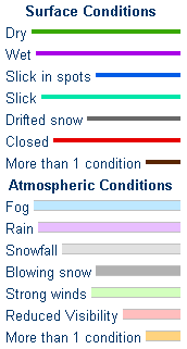
            Road Conditions and Web Cameras
Teton Pass - Hwy 22
Alpine Junction - U.S. Hwy 26/89/191
Jackson
Togwotee Mountain Lodge
Togwotee Pass - U.S. Hwy 26
Dubois
Granite Pass - U.S. Hwy 14
Powder River Pass - U.S. Hwy 16
South Pass - Hwy 28
Cody
Buffalo - I-25/I-90 Interchange
Casper Mountain
Casper
Beaver Rim - U.S. Hwy 287
I-80 - Rock Springs
I-80  - Laramie


                                                                       Click Here to See All Webcams                                                  

If you plan to travel, we recommend checking road conditions along your route and staying on top of road closures here. If you are on Twitter, follow the hashtag: #WyoRoad (or look below) for the latest weather affecting roads and road conditions in and around Wyoming. 


Get the play-by-play on this storm and contribute your own snow reports to #wywx

Follow Us on Twitter @NWSRiverton

On the road?

Tweet road conditions to #WyoRoad!


 Summary | Forecast | Observed Snow and WindTravel Center | Monitoring & Reporting | Safety

PLEASE SEND US YOUR SNOW REPORTS (CLICK HERE)

Monitor our Weather Summary Page for current Warnings, Watches, and Advisories. What's the difference?
Current            Weather Story Check the latest Weather Story graphic for an overview of the area forecast.
NWS Riverton Radar Check out what's on the radar.
Riverton | Pocatello | Cheyenne | Billings | Salt Lake City | Rapid City | Mosaic
Submit storm reports/images and keep up to date with us on Facebook!
Submit storm reports/images and keep up to date with us on Twitter!
Other reporting methods include email (nws.riverton@noaa.gov), or by phone at 1-800-211-1448.
Check the latest Public Information Statement for the latest storm reports.
WyDoT's Webpage Monitor current road conditions by visiting the Wyoming Dept. of Transportation (WYDOT) or by calling 5-1-1.
Get current road conditions, web camera images, road alerts, and much more on your mobile device by downloading the Wyoming 511 Mobile App.


Top Menu

 Summary | Forecast | Observed Snow and WindTravel Center | Monitoring & Reporting | Safety


Winter Safety Kit      |      Winter Weather Safety


Learn more about the National Weather Service's efforts to build a Weather-Ready Nation!


 Top Menu