Extremely critical fire weather concerns for portions of the southern High Plans as strong wind and very dry conditions could result in rapid spread of any fires. Meanwhile, severe thunderstorms are expected once again across areas of the Central and Southern Plains, then spreading in the Mississippi Valley regions on Monday. Damaging winds, very large hail and strong tornadoes are possible. Read More >
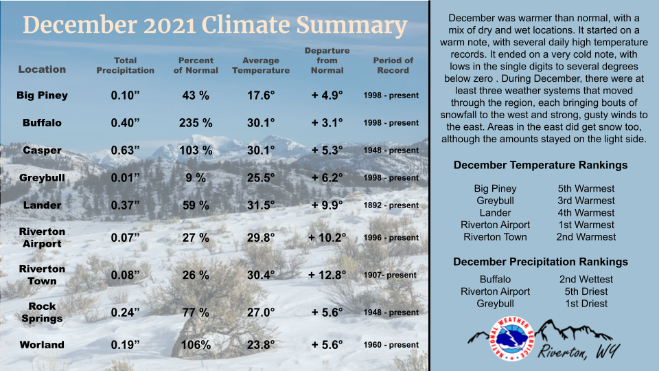
| The December 2021 climate summaries for Big Piney, Buffalo, Casper, Greybull, Lake Yellowstone, Lander, Riverton, Rock Springs, and Worland are now available online. |
 |
|
December was warmer than normal, starting on a very warm note with several record high temperatures on the 1st and 2nd. It stayed fairly mild, temperature wise, through the month until the final week of the year. An arctic airmass snuck in behind a cold front and brought lows as cold as -15, and highs only in the teens and low 20s. It was also quite windy through the month, with several High Wind Warnings being issued. The average monthly temperatures were from 3 degrees above normal to as much as 12.8 degrees above normal in Riverton. The warmest days of the month were the first 3 days. The coldest days were the 17th to18th with a good cold front, and between the 29th and 31st with the arctic air. There were some record lows set at the end of the month. Precipitation for the month was primarily snow, and mainly occurred in the west through the month. Buffalo did have its second wettest December, while Greybull had its driest. Three main weather fronts came through Wyoming in December, each bringing bands of snow. There was a cold front on the 9th and 10th, and another one on the 15th. A third system hit on Christmas Eve through the 26th. Each of these systems dropped a few areas of record breaking precipitation, in the way of melted snow, with a few daily records being set. Many areas only received small amounts of snow and stayed on the dry side of normal. Check the CLMs for more specifics on daily records set at the various locations. See the links above for details for individual sites or click here for Water Year Precipitation summaries for more locations. If you would like additional, or more in-depth climate information, please refer to our Climate Page. From the Riverton Home Page, hover over the "Climate and Past Weather" tab, and select the "Local" option. Under the "Observed Weather" tab you can then find the Daily Climate Report (CLI), the Preliminary Monthly Climate Data (CF6), the Monthly Weather Summary (CLM), and the Regional Summary (RTP). The Daily Climate Report will have the weather data for the day (from midnight to 1159 pm). The Monthly Climate Data (CF6) will have this data for each day of the month, compiling all the daily data into one form. The Regional Summary will have temperature and precipitation data for various locations across the state, updated 3 times a day. |
|