Extremely critical fire weather concerns for portions of the southern High Plans as strong wind and very dry conditions could result in rapid spread of any fires. Meanwhile, severe thunderstorms are expected once again across areas of the Central and Southern Plains, then spreading in the Mississippi Valley regions on Monday. Damaging winds, very large hail and strong tornadoes are possible. Read More >
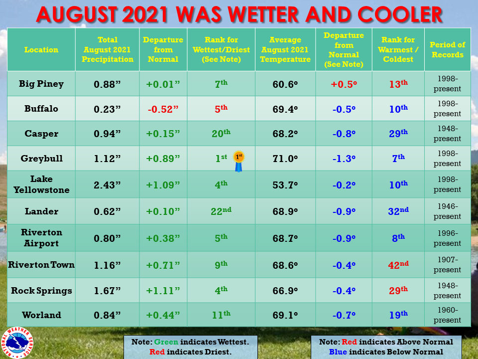
| The August 2021 climate summaries for Big Piney, Buffalo, Casper, Greybull, Lake Yellowstone, Lander, Riverton, Rock Springs, and Worland are now available online. |
 |
|
August was wetter and colder than normal. The Cowboy State was influenced by monsoonal moisture, with the 2nd and 3rd seeing quite a bit of rain. Rock Springs received 1.14 inches of rain on the 2nd. Another bout of monsoon rainfall hit between the 18th and 21st. During August, almost every location had above normal precipitation. Greybull had its wettest August on record. Buffalo stayed on the drier side in August. Although surrounding areas did show a bit more rainfall than the airport reported. The average monthly temperatures were generally half a degree to 1 degree below normal in August. Only Big Piney stayed warmer than normal. The 29th was popular for the coldest morning of the month, with the 10th and 21st also being cold. There were even a few daily record lows on each of those days. The hottest days fell in the middle of the month, between the 14th and 16th with highs in the upper 90s. A few record daily highs were set. There were no 100 degree days for the climate sites in August this year, although 3 volunteer sites did hit the century mark, all on the 17th. The month ended on a dry, smoky week with temperatures on the last couple of days climbing again to just a bit above normal. Check the CLMs for more specifics on daily records set at the various locations. See the links above for details for individual sites or click here for Water Year Precipitation summaries for more locations. If you would like additional, or more in-depth climate information, please refer to our Climate Page. From the Riverton Home Page, hover over the "Climate and Past Weather" tab, and select the "Local" option. You can then find the Daily Climate Report (CLI), the Preliminary Monthly Climate Data (CF6), the Monthly Weather Summary (CLM), and the Regional Summary (RTP). The Daily Climate Report will have the weather data for the day (from midnight to 1159 pm). The Monthly Climate Data (CF6) will have this data for each day of the month, compiling all the daily data into one form. The Regional Summary will have temperature and precipitation data for various locations across the state, updated 3 times a day. |
|