Extremely critical fire weather concerns for portions of the southern High Plans as strong wind and very dry conditions could result in rapid spread of any fires. Meanwhile, severe thunderstorms are expected once again across areas of the Central and Southern Plains, then spreading in the Mississippi Valley regions on Monday. Damaging winds, very large hail and strong tornadoes are possible. Read More >
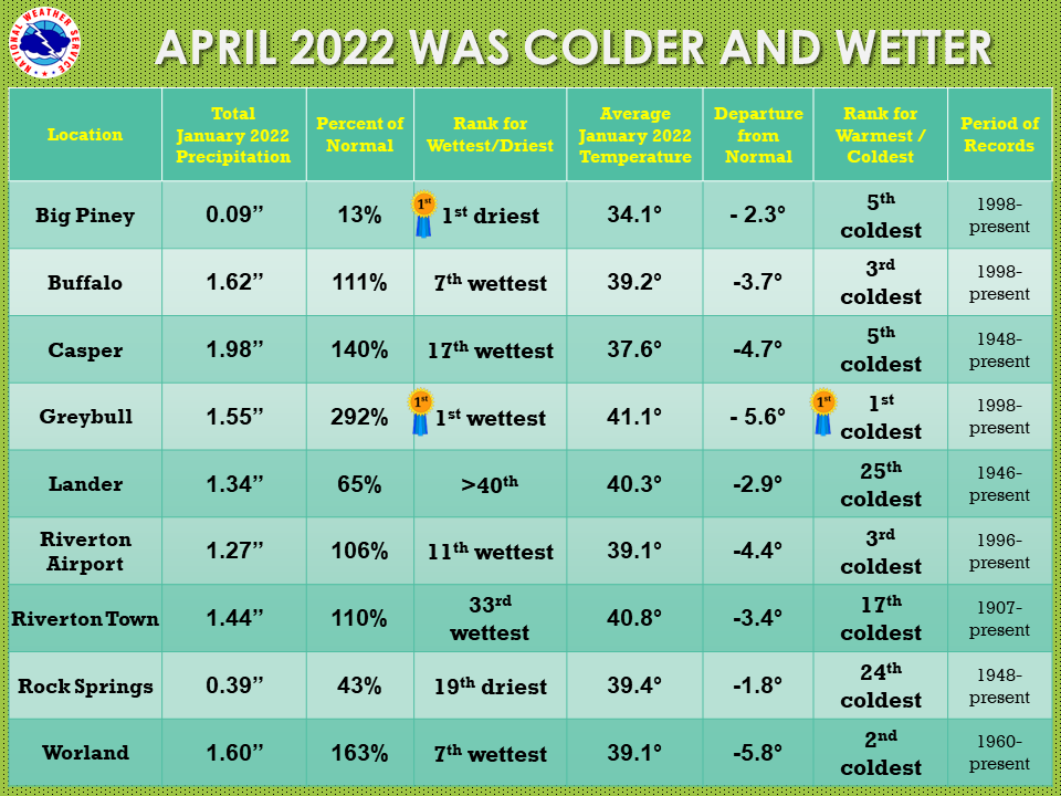
| The April 2022 climate summaries for Big Piney, Buffalo, Casper, Greybull, Lake Yellowstone, Lander, Riverton, Rock Springs, and Worland are now available online. |
 |
|
The month of April across Wyoming saw the average temperatures below normal. Precipitation for the month was mostly above normal, with just Rock Springs and Lander below normal, and Big Piney seeing the 1st driest April. Greybull came in at both 1st wettest and 1st coldest for the month. April started off with several very windy days and elevated fire weather concerns. Temperatures were not too hot or cold, but it was quite dry. There was a little snow in the western mountains on the first couple of days, but nothing noteworthy. The second week of the month was exciting with High Wind Warnings across most of the state, and Winter Weather Advisories for the western mountains and Yellowstone National Park. A major trough with a jet core of 160 knots pushed across the state and winds lasted for nearly 3 days. Gusts up to 88 mph were reported with Riverton Airport getting a max of 68 mph and Buffalo seeing 61 mph. Many locations saw gusts in excess of 60 mph. Bands of snow dropped 2 to 4 inches on random locations across the region. A nice snowstorm with high winds passed through on the 11th and 12th. This was followed by some cold air and record lows on the 13th and 14th. The west saw continued snowfall through that week. The hottest day of the month fell on the 21st and 22nd, just prior to another major storm. That next event hit on the 22nd and 23rd, bringing heavy rain and mountain snowfall. Several daily rainfall records were broken that day. The state saw its first real outbreak of thunderstorms, with gusty winds and small hail on the 28th and 29th. That storm also brought some much needed rainfall to the area. Check the CLMs for more specifics on daily records set at the various locations. See the links above for details for individual sites or click here for Water Year Precipitation summaries for more locations. If you would like additional, or more in-depth climate information, please refer to our Climate Page. From the Riverton Home Page, hover over the "Climate and Past Weather" tab, and select the "Local" option. Under the "Observed Weather" tab you can then find the Daily Climate Report (CLI), the Preliminary Monthly Climate Data (CF6), the Monthly Weather Summary (CLM), and the Regional Summary (RTP). The Daily Climate Report will have the weather data for the day (from midnight to 1159 pm). The Monthly Climate Data (CF6) will have this data for each day of the month, compiling all the daily data into one form. The Regional Summary will have temperature and precipitation data for various locations across the state, updated 3 times a day. |
|