Bitter cold temperatures and dangerous wind chills will persist from Florida to the Northeast through Monday. Daily record low temperatures are forecast across the Southeast and Florida, with some all-time February low temperature records possible across Florida. An Alberta clipper will spread wintry precipitation across the Northern Plains today and into the upper Great Lakes into tonight. Read More >
Overview
 |
 |
 |
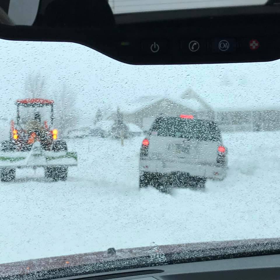
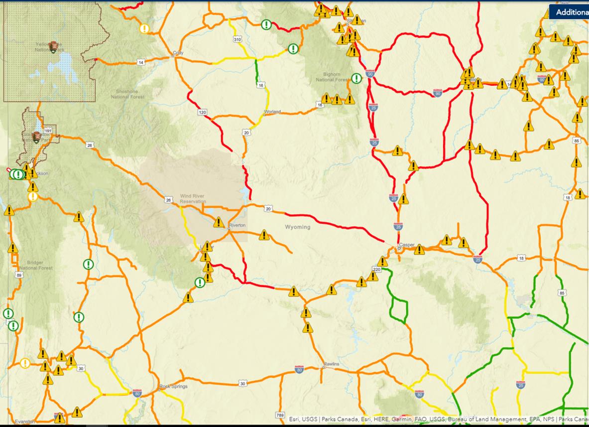
| Star Valley on December 30th | Large snow drifts near Buffalo Monday morning | Snapshot of Wyoming road closures (red shading) as of 6 AM Monday |
Wind:
24 HOUR PEAK WIND GUSTS FROM 9 PM SUNDAY UNTIL 9
PM MONDAY.

...BIG HORN COUNTY...
30 E GREYBULL                60 MPH    1258 AM 12/31   8898
GREYBULL AIRPORT             56 MPH    1138 PM 12/30   3935
5 ENE HYATTVILLE             51 MPH    1152 PM 12/30   5670
COWLEY AIRPORT               47 MPH    0755 PM 12/30   4090

...FREMONT COUNTY...
2 W SOUTH PASS CITY          55 MPH    1146 AM 12/31   8185
7 SW MUDDY GAP               53 MPH    0450 PM 12/30   7380
8 W SOUTH PASS CITY          47 MPH    0650 AM 12/31   8120
BOYSEN RESERVOIR             43 MPH    0730 AM 12/31   4710
BEAVER RIM                   42 MPH    1016 PM 12/30   6784
RIVERTON AIRPORT             41 MPH    0605 AM 12/31   5525

...HOT SPRINGS COUNTY...
BOYSEN PEAK                  61 MPH    0735 AM 12/31   7300
10 S MEETEETSE               55 MPH    1142 PM 12/30   7127
9 WNW THERMOPOLIS            47 MPH    1035 PM 12/30   4902
KIRBY                        41 MPH    0930 PM 12/30   4350

...JOHNSON COUNTY...
25 ESE BUFFALO               66 MPH    0145 AM 12/31   4657
BUFFALO AIRPORT              58 MPH    0817 PM 12/30   4970
5 ESE STORY                  54 MPH    0911 PM 12/30   4673
7 NE BUFFALO                 50 MPH    1100 PM 12/30   4370
LINCH                        44 MPH    1231 AM 12/31   4934
20 SW ECHETA                 44 MPH    1225 AM 12/31   4068
KAYCEE                       42 MPH    0945 PM 12/30   4681

...NATRONA COUNTY...
8 S CASPER                   48 MPH    0252 AM 12/31   7740
16 S HILAND                  48 MPH    1110 PM 12/30   6380
20 N CASPER                  47 MPH    1021 PM 12/30   5677
CASPER AIRPORT               43 MPH    1138 PM 12/30   5320
7 W ALCOVA                   43 MPH    0320 AM 12/31   6342

...PARK COUNTY...
8 N MEETEETSE                66 MPH    0806 PM 12/30   5926
2 N FRANNIE                  50 MPH    0953 PM 12/30   4275
POWELL AIRPORT               46 MPH    1015 PM 12/30   5050
CODY AIRPORT                 43 MPH    0706 PM 12/30   5100
POWELL                       41 MPH    1110 PM 12/30   4386

...SUBLETTE COUNTY...
21 W BIG PINEY               44 MPH    0709 PM 12/30   8200

...SWEETWATER COUNTY...
15 SE ROCK SPRINGS           58 MPH    0444 PM 12/30   7550
1 NNE GREEN RIVER            47 MPH    0947 AM 12/31   6315
ROCK SPRINGS AIRPORT         46 MPH    1103 AM 12/31   6760
I 80 - MILE MARKER 184       45 MPH    1101 AM 12/31   7112
I 80 - MILE MARKER 142       42 MPH    0455 PM 12/31   7162
FARSON                       42 MPH    0830 AM 12/31   6594

...TETON COUNTY...
SUMMIT - JACKSON RESORT      59 MPH    0530 AM 12/31   10318
6 NW MOOSE                   41 MPH    0500 PM 12/30   9770

...WASHAKIE COUNTY...
10 SSE WORLAND               55 MPH    1017 PM 12/30   4520
WORLAND AIRPORT              54 MPH    0946 PM 12/30   4245
1 NNE WORLAND                51 MPH    1145 PM 12/30   4065
Snow
Public Information Statement
National Weather Service Riverton WY
509 PM MST Tue Jan 01 2019

...December 29-31, 2018 Storm Total Snowfall Reports...

The following are storm total snowfall reports from Saturday evening
through Monday evening; December 29-31, 2018.

Observations are collected from a variety of sources with varying
equipment and exposures. We thank all volunteer weather observers
for their dedication. Not all data listed are considered official.

***** Snowfall Reports *****

Location                              Snowfall

Big Horn County...
 Bald Mountain Snotel...              9 inches.
 Bone Springs Divide Snotel...        3 inches.
 1 W Lovell...                        1 inch.
 9 NNW Shell...                     0.5 inches.
 2 SSW Lovell...                    0.5 inches.
 Shell...                           0.3 inches.

Fremont County...
 6.6 SW Lander...                    16 inches.
 6 SW Lander...                    14.8 inches.
 9 SW Lander...                      11 inches.
 9 SSE Lander...                   10.1 inches.
 9 SSE Lander...                     10 inches.
 St. Lawrence Alt Snotel...           9 inches.
 3 SW Lander...                       9 inches.
 Townsend Creek Snotel...             7 inches.
 Atlantic City...                   6.7 inches.
 Lander...                          6.4 inches.
 7 WNW Lander...                    6.2 inches.
 Brooks Lake...                     6.1 inches.
 1 N Lander...                        6 inches.
 Hobbs Park Snotel...                 6 inches.
 Cold Springs Snotel...               5 inches.
 Lander Airport...                  4.6 inches.
 South Pass Snotel...                 4 inches.
 Deer Park Snotel...                  4 inches.
 Boysen Dam...                        4 inches.
 1 W Riverton...                    3.3 inches.
 Riverton...                        3.2 inches.
 Burroughs Creek Snotel...            3 inches.
 Little Warm Snotel...                3 inches.
 Riverton Airport...                2.2 inches.
 Jeffrey City...                      2 inches.
 4 W Riverton...                      2 inches.
 2 W Riverton...                      2 inches.
 Castle Creek Snotel...               2 inches.
 Burris...                            1 inch.
 Dubois...                          0.5 inches.

Hot Springs County...
 Thermopolis...                 8 to 12 inches.
 Owl Creek Snotel...                  7 inches.
 Lucerne...                           6 inches.
 9 NE Thermopolis...                  4 inches.

Johnson County...
 Little Goose Snotel...               9 inches.
 Bear Trap Meadow Snotel...           8 inches.
 Cloud Peak Reservoir Snotel...       8 inches.
 Soldier Park Snotel...               7 inches.
 Hansen Sawmill Snotel...             6 inches.
 4 SSW Buffalo...                     5 inches.
 13 SSE Buffalo...                    4 inches.
 Buffalo...                           4 inches.

Lincoln County...
 Alpine...                           10 inches.
 Blind Bull Summit...                 9 inches.
 Willow Creek Snotel...               9 inches.
 Commissary Ridge...                  9 inches.
 5 NNE Thayne...                      8 inches.
 Cottonwood Creek Snotel...           8 inches.
 Blind Bull Summit Snotel...          7 inches.
 Box Y Ranch...                       7 inches.
 3 SE Bedford...                      7 inches.
 5 SSE Smoot...                       6 inches.
 2 SE Thayne...                       6 inches.
 Indian Creek Snotel...               6 inches.
 Spring Creek Divide Snotel...        6 inches.
 Afton...                           4.4 inches.
 Hams Fork Snotel...                  4 inches.
 Salt River Summit Snotel...          4 inches.
 Kelley Ranger Station Snotel...      3 inches.

Natrona County...
 Casper Mountain Snotel...            8 inches.
 1 S Casper...                      6.6 inches.
 10 WSW Casper...                     6 inches.
 5 SSW Casper...                      6 inches.
 Grave Springs Snotel...              6 inches.
 Reno Hill Snotel...                  5 inches.
 4 WSW Casper...                    4.8 inches.
 Casper...                   2.5 to 4.5 inches.
 Powder River...                      4 inches.
 Casper Airport...                  2.2 inches.

Park County...
 Marquette Snotel...                 10 inches.
 Blackwater Snotel...                 9 inches.
 Wolverine Snotel...                  7 inches.
 Pahaska...                           6 inches.
 Timber Creek Snotel...               6 inches.
 3 NE Sunshine...                   4.4 inches.
 Beartooth Lake Snotel...             4 inches.
 Kirwin Snotel...                     4 inches.
 26 SW Cody...                        3 inches.
 Evening Star Snotel...               3 inches.
 2 WSW Cody...                      2.5 inches.
 Cody...                     0.5 to 2.3 inches.
 Younts Peak Snotel...                1 inch.
 3 NE Clark...                        1 inch.
 4 SW Powell...                     0.5 inches.
 4 ENE Powell...                    0.2 inches.
 Powell...                          0.1 inches.

Sublette County...
 Kendall Ranger Station Snotel...     9 inches.
 Triple Peak Snotel...                8 inches.
 Snider Basin Snotel...               7 inches.
 New Fork Lake Snotel...              7 inches.
 Gunsite Pass Snotel...               6 inches.
 Loomis Park Snotel...                6 inches.
 East Rim Divide Snotel...            5 inches.
 Elkhart Park G.S. Snotel...          4 inches.
 Bondurant...                       3.7 inches.
 Big Sandy Opening Snotel...          3 inches.
 Pocket Creek Snotel...               3 inches.
 14 NW Pinedale...                  2.8 inches.
 Pinedale...                          2 inches.

Sweetwater County...
 Wamsutter...                         2 inches.
 Green River...                     0.5 inches.
 4 NNW Rock Springs...              0.4 inches.
 Rock Springs...                    0.1 inches.

Teton County...
 Grand Targhee Snotel...             20 inches.
 6 NW Moose...                       19 inches.
 Grand Targhee - Chief Joseph...     18 inches.
 Jackson Hole - Raymer...          17.5 inches.
 Jackson Hole - Mid Mountain...      15 inches.
 Grassy Lake Snotel...               13 inches.
 Jackson Hole - Rendezvous Bowl... 10.5 inches.
 Togwotee Mountain Lodge...          10 inches.
 Togwotee Pass Snotel...             10 inches.
 Phillips Bench Snotel...             8 inches.
 Snake River Stn Snotel...            8 inches.
 3 SSW Wilson...                      8 inches.
 2 NE Teton Village...              5.3 inches.
 Gros Ventre Summit Snotel...         5 inches.
 Base Camp Snotel...                  5 inches.
 Granite Creek Snotel...              5 inches.
 Snow King...                         4 inches.
 Jackson Dam...                     3.8 inches.
 Jackson Hole - Base...             3.5 inches.
 1 NNW Alta...                        3 inches.
 5 NW Jackson...                    1.8 inches.
 Jackson...                         1.2 inches.

Washakie County...
 Middle Powder Snotel...             10 inches.
 27 S Ten Sleep...                    7 inches.
 Powder River Pass Snotel...          5 inches.
 16 SSE Ten Sleep...                  5 inches.
 Ten Sleep...                       2.8 inches.
 5 NNW Ten Sleep...                 2.6 inches.
 8 SW Worland...                      1 inch.
 Winchester...                        1 inch.

Yellowstone National Park...
 Two Ocean Plateau Snotel...         11 inches.
 Lewis Lake Divide Snotel...         10 inches.
 Sylvan Lake Snotel...                9 inches.
 Canyon Snotel...                     9 inches.
 Yellowstone East Entrance...         8 inches.
 Sylvan Road Snotel...                7 inches.
 Parker Peak Snotel...                7 inches.
 Tower Falls Ranger Station...      5.7 inches.
 Old Faithful Ranger Station...       5 inches.
 Lamar Ranger Station...            3.6 inches.
 Thumb Divide Snotel...               3 inches.

$$
 |
Media use of NWS Web News Stories is encouraged! |
 |