Extremely critical fire weather concerns for portions of the southern High Plans as strong wind and very dry conditions could result in rapid spread of any fires. Meanwhile, severe thunderstorms are expected once again across areas of the Central and Southern Plains, then spreading in the Mississippi Valley regions on Monday. Damaging winds, very large hail and strong tornadoes are possible. Read More >
Overview
 |
 |
 |
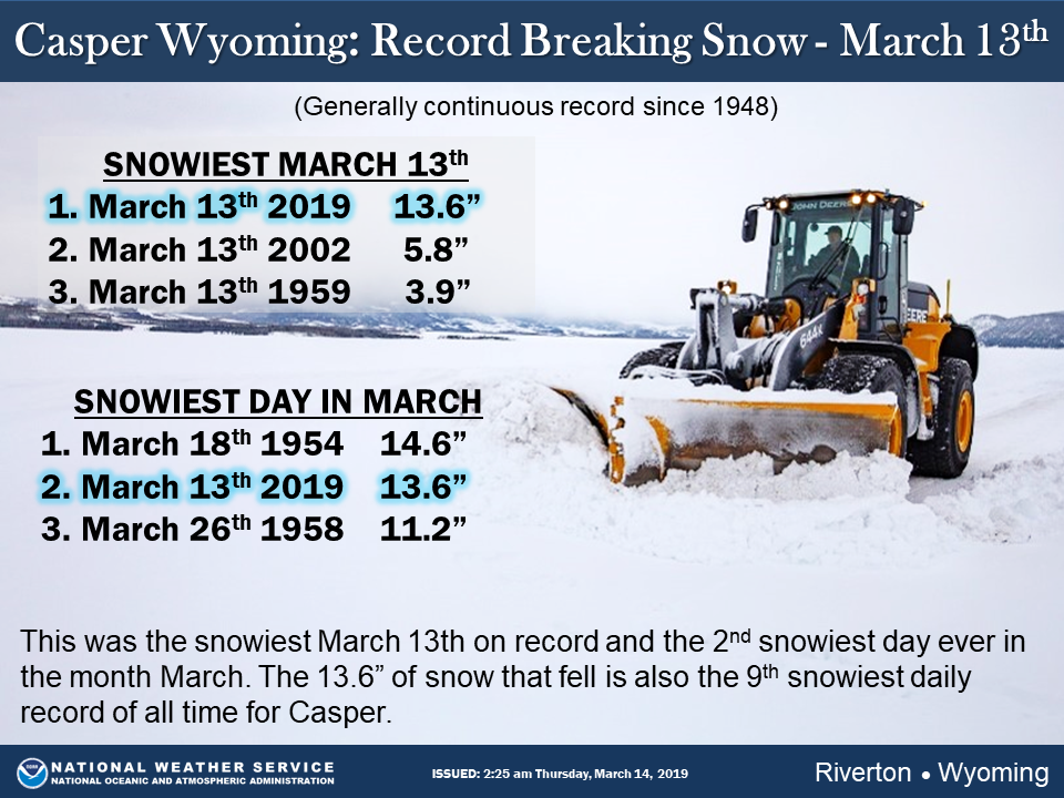
| Daily Snowfall Record for Casper | Conditions in Casper at 5 AM March 13th | Snow in Casper (Courtesy of Brian W.) |
 |
 |
| Snowfall analysis of the blizzard (source: NOHRSC) |
Snowfall analysis from this winter storm zoomed into Wyoming (source: NOHRSC) |
Wind:
LOCATION                     SPEED     TIME/DATE   ELEVATION (FT.)

...BIG HORN COUNTY...
30 E GREYBULL                56 MPH    0758 PM 03/13   8898
GREYBULL AIRPORT             55 MPH    0612 PM 03/13   3935
5 ENE LOVELL                 41 MPH    1200 PM 03/13   4055

...FREMONT COUNTY...
13 NW LOST CABIN             64 MPH    0906 PM 03/13   6110
8 W SOUTH PASS CITY          43 MPH    0550 PM 03/13   8120
BOYSEN RESERVOIR             40 MPH    0830 PM 03/13   4710

...HOT SPRINGS COUNTY...
10 S MEETEETSE               44 MPH    0942 PM 03/13   7127

...JOHNSON COUNTY...
BUFFALO AIRPORT              56 MPH    0919 PM 03/13   4970
12 N KAYCEE                  52 MPH    0121 PM 03/13   5287
25 ESE BUFFALO               49 MPH    0510 PM 03/13   4657
5 ESE STORY                  48 MPH    0717 PM 03/13   4673
7 NE BUFFALO                 43 MPH    0616 PM 03/13   4370
7 SW BARNUM                  42 MPH    1046 AM 03/13   6440
KAYCEE                       41 MPH    0445 PM 03/13   4681

...LINCOLN COUNTY...
13 W KEMMERER                40 MPH    1201 PM 03/13   6718

...NATRONA COUNTY...
8 S CASPER                   56 MPH    0252 PM 03/13   7740
20 N CASPER                  48 MPH    0901 PM 03/13   5677
CASPER AIRPORT               47 MPH    1010 AM 03/13   5320
7 W ALCOVA                   46 MPH    1110 AM 03/13   6342
NATRONA                      45 MPH    1035 AM 03/13   5589
16 S HILAND                  42 MPH    1010 AM 03/13   6380

...PARK COUNTY...
8 N MEETEETSE                51 MPH    1111 AM 03/13   5926

...SWEETWATER COUNTY...
I 80 - MILE MARKER 184       52 MPH    1116 AM 03/13   7112
I 80 - MILE MARKER 157       43 MPH    0100 PM 03/13   6965
I 80 - MILE MARKER 142       41 MPH    1245 PM 03/13   7162
10 E WAMSUTTER               41 MPH    1100 AM 03/13   7062
15 SE ROCK SPRINGS           40 MPH    0944 AM 03/13   7550

...WASHAKIE COUNTY...
10 SSE WORLAND               41 MPH    0417 PM 03/13   4520
WORLAND AIRPORT              41 MPH    0505 PM 03/13   4245
Snow
LOCATION                              SNOWFALL

BIG HORN COUNTY...
 BALD MOUNTAIN SNOTEL...              8 INCHES.
 BONE SPRINGS DIVIDE SNOTEL...        5 INCHES.

FREMONT COUNTY...
 HOBBS PARK SNOTEL...                10 INCHES.
 TOWNSEND CREEK SNOTEL...            10 INCHES.
 ATLANTIC CITY...                     8 INCHES.
 9.5 SW LANDER...                     7 INCHES.
 DEER PARK SNOTEL...                  7 INCHES.
 ST. LAWRENCE ALT SNOTEL...           7 INCHES.
 COLD SPRINGS SNOTEL...               6 INCHES.
 6 SW LANDER...                     5.3 INCHES.
 SOUTH PASS SNOTEL...                 5 INCHES.
 JEFFREY CITY...                      4 INCHES.
 9 SSE LANDER...                    3.8 INCHES.
 BOYSEN DAM...                        2 INCHES.
 LANDER AIRPORT...                  1.8 INCHES.
 7 WNW LANDER...                    1.6 INCHES.
 LANDER...                     1 TO 1.5 INCHES.
 LITTLE WARM SNOTEL...                1 INCH.
 RIVERTON AIRPORT...                0.7 INCHES.
 HUDSON...                          0.5 INCHES.
 RIVERTON...                        0.3 INCHES.
 2 W RIVERTON...                    0.2 INCHES.
 BROOKS LAKE...                     0.1 INCHES.

HOT SPRINGS COUNTY...
 WIND RIVER CANYON...                 2 INCHES.
 OWL CREEK SNOTEL...                  1 INCH.

JOHNSON COUNTY...
 LITTLE GOOSE SNOTEL...              17 INCHES.
 CLOUD PEAK RESERVOIR SNOTEL...       7 INCHES.
 5 SE LINCH...                        6 INCHES.
 SOLDIER PARK SNOTEL...               5 INCHES.
 HANSEN SAWMILL SNOTEL...             3 INCHES.
 4 SSW BUFFALO...                   2.5 INCHES.
 BEAR TRAP MEADOW SNOTEL...           2 INCHES.
 17 E KAYCEE...                       2 INCHES.
 BUFFALO...                           2 INCHES.

LINCOLN COUNTY...
 AFTON...                           7.5 INCHES.
 WILLOW CREEK SNOTEL...               7 INCHES.
 5 SSE SMOOT...                       5 INCHES.
 SALT RIVER SUMMIT SNOTEL...          4 INCHES.
 COTTONWOOD CREEK SNOTEL...           4 INCHES.
 2 SE THAYNE...                     3.7 INCHES.
 DIAMONDVILLE...                    3.5 INCHES.
 3 SE BEDFORD...                      3 INCHES.
 3 S FONTENELLE DAM...                3 INCHES.
 FOSSIL BUTTE...                    1.3 INCHES.
 COMMISSARY RIDGE...                  1 INCH.
 INDIAN CREEK SNOTEL...               1 INCH.
 BLIND BULL SUMMIT...                 1 INCH.
 KELLEY RANGER STATION SNOTEL...      1 INCH.
 BOX Y RANCH...                     0.1 INCHES.
 5 NNE THAYNE...                    0.1 INCHES.
 STAR VALLEY RANCH...               0.1 INCHES.

NATRONA COUNTY...
 CASPER MOUNTAIN SNOTEL...           26 INCHES.
 RENO HILL SNOTEL...                 23 INCHES.
 1 SW CASPER...                      17 INCHES.
 2 E EVANSVILLE...                   15 INCHES.
 CASPER AIRPORT...                 14.7 INCHES.
 4 WSW CASPER...                   13.1 INCHES.
 5 SSW CASPER...                     13 INCHES.
 CASPER...                      9 TO 12 INCHES.
 1 S CASPER...                     11.5 INCHES.
 10 WSW CASPER...                   9.5 INCHES.
 GRAVE SPRINGS SNOTEL...              7 INCHES.
 MIDWEST...                           7 INCHES.
 POWDER RIVER...                    5.7 INCHES.

PARK COUNTY...
 3 NE SUNSHINE...                   2.3 INCHES.
 BLACKWATER SNOTEL...                 1 INCH.
 KIRWIN SNOTEL...                     1 INCH.
 MEETEETSE...                         1 INCH.
 MARQUETTE SNOTEL...                  1 INCH.
 11 SE CODY...                        1 INCH.
 26 SW CODY...                      0.3 INCHES.
 CODY...                            0.1 INCHES.

SUBLETTE COUNTY...
 TRIPLE PEAK SNOTEL...                1 INCH.
 PINEDALE...                        0.1 INCHES.

SWEETWATER COUNTY...
 WAMSUTTER...                        10 INCHES.
 2 NNE FARSON...                      8 INCHES.
 7 SE ROCK SPRINGS...               7.7 INCHES.
 ROCK SPRINGS...               5 TO 7.5 INCHES.
 4 NNW ROCK SPRINGS...              5.5 INCHES.
 GREEN RIVER...                  4 TO 5 INCHES.
 BUCKBOARD MARINA...                  2 INCHES.

TETON COUNTY...
 GRAND TARGHEE - CHIEF JOSEPH...      7 INCHES.
 GRAND TARGHEE SNOTEL...              5 INCHES.
 DARWIN RANCH...                      3 INCHES.
 GROS VENTRE SUMMIT SNOTEL...         3 INCHES.
 6 NW MOOSE...                        1 INCH.
 SNOW KING...                         1 INCH.
 JACKSON HOLE - RENDEZVOUS BOWL...    1 INCH.
 JACKSON HOLE - RAYMER...             1 INCH.
 JACKSON HOLE - MID MOUNTAIN...       1 INCH.
 TOGWOTEE MOUNTAIN LODGE...         0.1 INCHES.
 MOOSE...                           0.1 INCHES.

WASHAKIE COUNTY...
 MIDDLE POWDER SNOTEL...              5 INCHES.
 27 S TEN SLEEP...                  1.5 INCHES.
 16 SSE TEN SLEEP...                1.5 INCHES.
 POWDER RIVER PASS SNOTEL...          1 INCH.
 |
Media use of NWS Web News Stories is encouraged! Please acknowledge the NWS as the source of any news information accessed from this site. |
 |