National Weather Service United States Department of Commerce

Storm Impacting the Northwest U.S.; Fire Weather Conditions in Southern California; Severe Weather in the South

A Pacific storm is bringing areas of low elevation rain, moderate to heavy mountain snow, and high winds to the Northwest. Strong Santa Ana winds and very dry conditions are producing elevated to critical fire weather conditions in southern California. Isolated strong to severe thunderstorms are possible through early Wednesday morning across parts of northeast Texas into western Tennessee. Read More >

Summary | Forecast | Observed Snow and Wind | Travel Center | Monitoring & Reporting | Safety


SYNOPSIS:  A Canadian winter storm system brought significant snow to the area over the weekend and bitter cold temperatures that will continue through today.  Snow began in the northwest Saturday and ended Monday, moving southeast.  Some locations saw significant snowfall such as Casper, WY, which saw up to 14.5", making it their 21st biggest snowstorm since 1937.  Only a few mountain Snotels also recorded that much snow this storm.

Low temperatures were mostly -15F to -25F across north and central Wyoming Tuesday morning and this morning, with wind chills as low as 40 below at times.  Temperatures are only expected to get to between -5F and -20F tonight into Thursday morning with highs getting into the teens to low 20's. 


Top Menu


 Summary | Forecast | Observed Snow and WindTravel Center | Monitoring & Reporting | Safety
 

NWS Text Products and Forecasts

  Area Forecast Discussion
  Winter Weather Statement
  Special Weather Statement
  What's a "Watch?"
  Observed Snow Totals or High Wind
 High Wind Statement
 Weather Story

Storm Snow Totals
  Click to enlarge


Click Image To Enlarge
Snowfall totals for this weekend's winter storm


Quick View of Expected Wednesday Temperatures and coldest possible Wind Chill Temperatures
Click to enlarge Click to enlarge

Click Image To Enlarge
Recorded Tuesday Morning Lows 

Click Image To Enlarge
Forecast Low Temperatures on
Wednesday Morning, February 21st

Click to enlarge


Click Image To Enlarge
Forecast High Temperatures
on Wednesday, February 21st

 Top Menu


Low Temperatures Tuesday Night/Wednesday Morning 
(Please double check date and time of product)

                        
872
NOUS45 KRIW 191655 CCA
PNSRIW
WYZ001>020-022>030-200442-

Public Information Statement
National Weather Service Riverton WY
1042 AM MDT Sat Apr 19 2025

...Spring Snow Storm Totals...

An April snow storm brought widespread snow to central and western
Wyoming April 17th, with some snow lingering into the morning of the
18th. Highest totals were in the Lander area. Below are totals from
April 17th through the morning of the 18th.

Location                     Amount     Elevation (ft.)

...Wyoming...

...Big Horn County...
Deaver                       1.0 in     4107
Cowley                       0.5 in     4015

...Fremont County...
10 SW Lander                 26.0 in    7145
7 SW Lander                  23.0 in    6400
6 SW Lander                  20.8 in    6043
13 SW Lander                 20.0 in    8725
9 S Lander                   19.5 in    5996
9 SSE Lander                 16.0 in    5800
2 SSE Lander                 15.3 in    5517
7 WNW Lander                 14.2 in    6040
7 NNW South Pass City        14.0 in    8936
14 SW Fort Washakie          14.0 in    10065
11 WSW Burris                13.0 in    9903
10 NNW South Pass City       12.0 in    9659
2 NNW Lander                 11.0 in    5340
2 SSE Fort Washakie          10.6 in    5543
15 W Fort Washakie           10.0 in    8444
6 WSW Dubois                 10.0 in    9411
1 NE Riverton                7.7 in     4950
2 W Riverton                 5.5 in     5070
1 WNW Dubois                 4.0 in     6955
6 WNW Riverton               2.3 in     5570
6 ESE Dubois                 1.5 in     6668
Shoshoni                     1.4 in     4837
12 NNW Shoshoni              1.0 in     4863

...Hot Springs County...
1 E Thermopolis              7.0 in     4322
2 NE Lucerne                 5.7 in     4275
1 WSW Lucerne                5.2 in     4432
15 WSW Hamilton Dome         3.7 in     6607

...Johnson County...
8 NNE Mayoworth              4.8 in     5058
3 SSW Mayoworth              2.0 in     5477
1 NNE Buffalo                2.0 in     4617
5 NNW Kaycee                 1.5 in     4911
5 SSW Buffalo                0.8 in     5295

...Lincoln County...
5 SSE Smoot                  7.0 in     6980
1 SE Thayne                  6.5 in     6071
4 NNE Thayne                 6.4 in     6248
2 S Bedford                  5.0 in     6296
4 NE Thayne                  4.6 in     6199
2 NNW Turnerville            4.1 in     6355
Afton                        3.0 in     6255
3 N Etna                     2.8 in     5927

...Natrona County...
7 S Casper                   13.0 in    8070
2 S Casper                   12.5 in    5511
3 SSW Mills                  10.0 in    5200
1 E Casper                   9.8 in     5280
1 NW Casper                  9.0 in     5139
1 SSE Mills                  7.0 in     5136
2 WSW Evansville             6.7 in     5102
5 W Mills                    4.0 in     5351
9 ENE Lost Cabin             4.0 in     6028

...Park County...
2 SE Meeteetse               6.9 in     6065
5 NNE Meeteetse              3.6 in     5516
2 WSW Cody                   3.0 in     5164
7 SW Ralston                 2.0 in     4763
7 NNE Cody                   1.8 in     4853
2 NE Cody                    1.0 in     4944
3 WSW Cody                   1.0 in     5293
3 NNE Clark                  0.8 in     4146
1 W Garland                  0.2 in     4288
3 NNW Clark                  0.1 in     4342

...Sublette County...
12 ESE Bondurant             11.0 in    7960
14 E Bondurant               10.0 in    8206
2 WSW Pinedale               9.3 in     7301
6 WNW Cora                   9.2 in
1 NNW Pinedale               7.0 in     7204
Marbleton                    6.3 in     6851
5 SE Pinedale                1.5 in     7137

...Sweetwater County...
Wamsutter                    6.0 in     6730
7 SSE Rock Springs           4.5 in     6752
4 WSW Reliance               4.0 in     6480
2 SSW Rock Springs           3.2 in     6280
1 SSW Green River            3.0 in     6309
2 NNE Farson                 3.0 in     6623
2 W Rock Springs             2.7 in     6390
2 SSE Green River            2.0 in     6203
1 SSE Green River            2.0 in     6220
1 NNW Green River            2.0 in     6097
2 SE Green River             1.9 in     6165

...Teton County...
19 NE Bondurant              8.0 in     8770
6 ENE Alta                   7.0 in     9260
23 ESE Moran Junction        5.0 in     9612
2 NW Wilson                  5.0 in     8017
Old Faithful                 3.5 in     7358
10 N Bondurant               3.0 in     6912
3 SSW Wilson                 2.0 in     6996
Kelly                        1.0 in     6652

...Washakie County...
9 S Manderson                8.0 in     4039
9 SSW Big Trails             4.3 in     5005
5 N Ten Sleep                4.3 in     4753
Winchester                   4.0 in     4211
6 NE Winchester              4.0 in     4157
Ten Sleep                    3.8 in     4422

Observations are collected from a variety of sources with varying
equipment and exposures. We thank all volunteer weather observers
for their dedication. Not all data listed are considered official.

$$


 Top Menu


Summary | Forecast | Observed Snow and WindTravel Center | Monitoring & Reporting | Safety

Current Radar & Web Cams - Click Thumbnails To Enlarge
Northern Rockies Radar
Riverton Radar
Pocatello
Billings
Salt Lake
Cheyenne


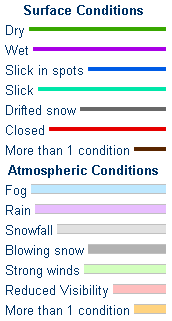
            Road Conditions and Web Cameras
Teton Pass - Hwy 22
Alpine Junction - U.S. Hwy 26/89/191
Jackson
Togwotee Mountain Lodge
Togwotee Pass - U.S. Hwy 26
Dubois
Granite Pass - U.S. Hwy 14
Powder River Pass - U.S. Hwy 16
South Pass - Hwy 28
Cody
Buffalo - I-25/I-90 Interchange
Casper Mountain
Casper
Beaver Rim - U.S. Hwy 287
I-80 - Rock Springs
I-80  - Laramie


                                                                       Click Here to See All Webcams                                                  

If you plan to travel, we recommend checking road conditions along your route and staying on top of road closures here. If you are on Twitter, follow the hashtag: #WyoRoad (or look below) for the latest weather affecting roads and road conditions in and around Wyoming. 


Get the play-by-play on this storm and contribute your own snow reports to #wywx

Follow Us on Twitter @NWSRiverton

On the road?

Tweet road conditions to #WyoRoad!


 Summary | Forecast | Observed Snow and WindTravel Center | Monitoring & Reporting | Safety

PLEASE SEND US YOUR SNOW REPORTS (CLICK HERE)

Monitor our Weather Summary Page for current Warnings, Watches, and Advisories. What's the difference?
Current            Weather Story Check the latest Weather Story graphic for an overview of the area forecast.
NWS Riverton Radar Check out what's on the radar.
Riverton | Pocatello | Cheyenne | Billings | Salt Lake City | Rapid City | Mosaic
Submit storm reports/images and keep up to date with us on Facebook!
Submit storm reports/images and keep up to date with us on Twitter!
Other reporting methods include email (nws.riverton@noaa.gov), or by phone at 1-800-211-1448.
Check the latest Public Information Statement for the latest storm reports.
WyDoT's Webpage Monitor current road conditions by visiting the Wyoming Dept. of Transportation (WYDOT) or by calling 5-1-1.
Get current road conditions, web camera images, road alerts, and much more on your mobile device by downloading the Wyoming 511 Mobile App.


Top Menu

 Summary | Forecast | Observed Snow and WindTravel Center | Monitoring & Reporting | Safety


Winter Safety Kit      |      Winter Weather Safety


Learn more about the National Weather Service's efforts to build a Weather-Ready Nation!


 Top Menu