Extremely critical fire weather concerns for portions of the southern High Plans as strong wind and very dry conditions could result in rapid spread of any fires. Meanwhile, severe thunderstorms are expected once again across areas of the Central and Southern Plains, then spreading in the Mississippi Valley regions on Monday. Damaging winds, very large hail and strong tornadoes are possible. Read More >
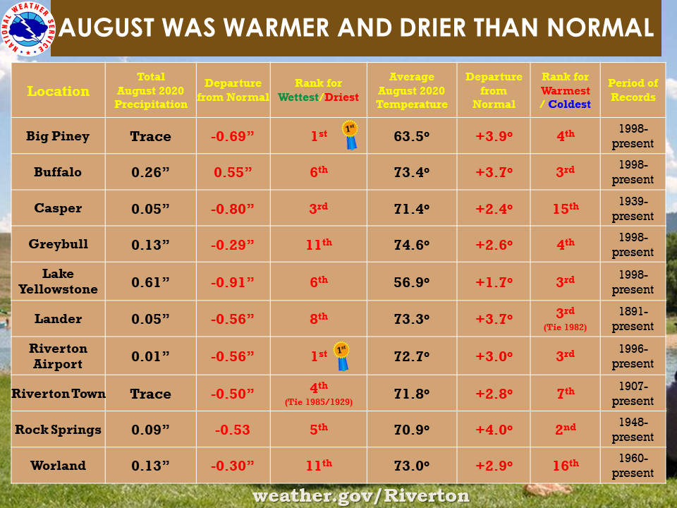
| The August 2020 climate summaries for Big Piney, Buffalo, Casper, Greybull, Lake Yellowstone, Lander, Riverton, Rock Springs, and Worland are now available online. |
 |
|
The month of August was warmer and drier than normal. Big Piney and Riverton Airport both had their driest August since records have been kept in 1998. Only one daily precipitation record was set, this one at Greybull on the 27th. They received 0.03 inches of rain, breaking a Trace set in 2010. The month started off warm and ended with a few cold days at the end. The hottest days of the month were on the 3rd, 17th or 18th for most of the sites. Several temperature records were broken across the stations, both lows and highs. On the 17th Greybull hit 102 degrees and Worland hit 101 degrees, both breaking records from 2013. The town of Riverton which has a long history tied the record high of 96 degrees on the 18th from previous years of 2013, 1986 and 1973. Big Piney (84.1/2012), Lander (89.4/2011), Lake Yellowstone (74.8/2013 tied) Riverton Airport (88.8/2000) and Rock Springs (87.4/1971) all had the warmest average monthly High temperature on record for August. The previous records are in the parenthesis. Casper tied the 1977 low temperature record on the 31st with just 33 degrees. Check the CLMs for more specifics on daily records set at the various locations. See the links above for details for individual sites or click here for Water Year Precipitation summaries for more locations. If you would like additional, or more in-depth climate information, please refer to our Climate Page. From the Riverton Home Page, hover over the "Climate and Past Weather" tab, and select the "Local" option. You can then find the Daily Climate Report (CLI), the Preliminary Monthly Climate Data (CF6), the Monthly Weather Summary (CLM), and the Regional Summary (RTP). The Daily Climate Report will have the weather data for the day (from midnight to 1159 pm). The Monthly Climate Data (CF6) will have this data for each day of the month, compiling all the daily data into one form. The Regional Summary will have temperature and precipitation data for various locations across the state, updated 3 times a day. |
|