
Tropical Depression Two is expected to gradually strengthen and could bring tropical storm conditions to the Florida Panhandle beginning late Monday. Areas of flash flooding will be possible through Thursday along the eastern and central Gulf Coast. Severe thunderstorms will develop and move along a cold front crossing the Upper Midwest Monday, and through the Ohio Valley/Mid-Atlantic on Tuesday. Read More >
Pacific ENSO Applications Climate Services
National Division
ENSO (+1) Years |
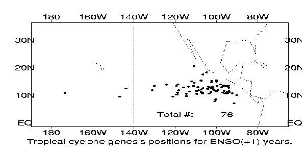
Tropical Cyclone Genesis Positions: ENSO (+1) Years |
 |
|
Tropical Cyclone Genesis Positions in the Eastern Pacific for ENSO (+1) years (1973, 77, 83, 87, 93). The number in the figure denotes total number of storms in the five years.
|
Tropical Cyclone Tracks: ENSO (+1) Years |
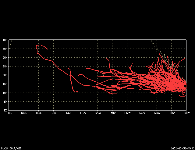 |
| Tropical Cyclone Tracks in the Eastern Pacific for ENSO (+1) years (1973, 77, 83, 87, 93, 98). In the six years there were a total of 89 storms. |
US Dept of Commerce
National Oceanic and Atmospheric Administration
National Weather Service
Pacific ENSO Applications Climate Services
Pacific ENSO Applications Climate Services
2525 Correa Rd. HIG room 340
Honolulu, HI 96822
8089562324
Comments? Questions? Please Contact Us.

