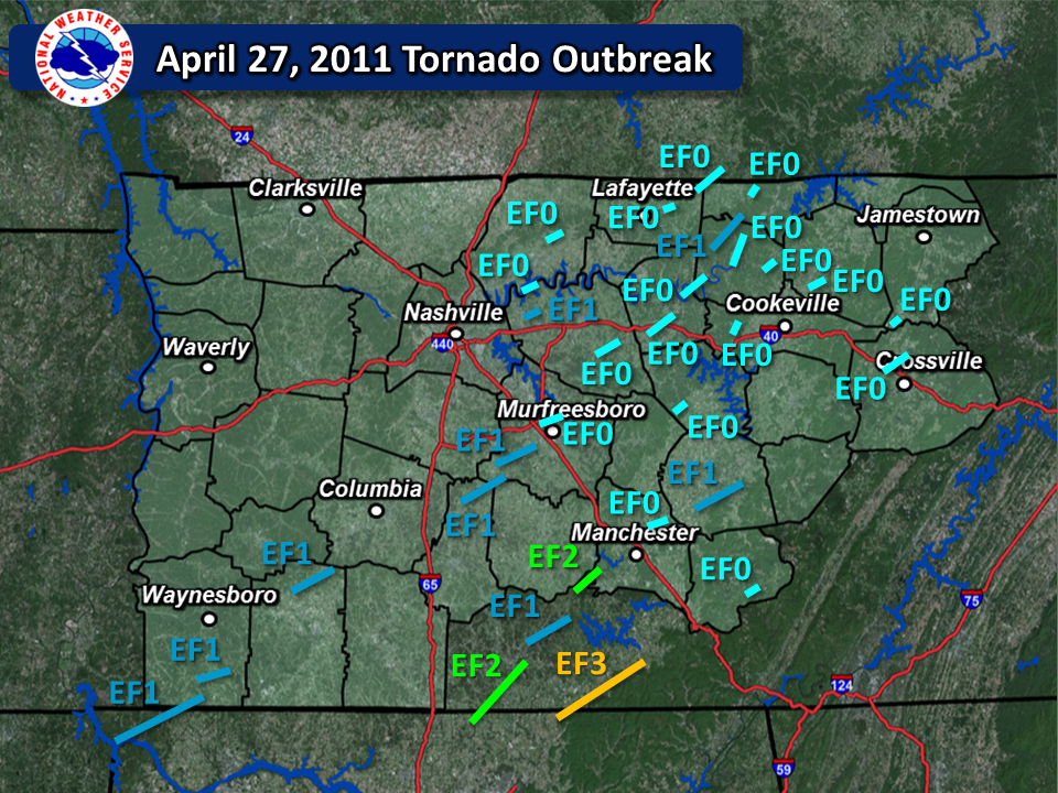
| April 27, 2011 Super Outbreak Tornadoes | ||||||||
| # | Counties | Rating | Time (CST) | Length (miles) | Width (yards) | Fatalities | Injuries | |
| 1 | Lauderdale AL/Wayne TN | EF1 | 0301 | 14.0 | 300 | 0 | 0 | |
| 2 | Wayne | EF1 | 0319 | 6.16 | 200 | 0 | 0 | |
| 3 | Lawrence/Maury | EF1 | 0350 | 11.14 | 300 | 0 | 1 | |
| 4 | Wilson | EF0 | 0422 | 3.04 | 50 | 0 | 0 | |
| 5 | Wilson | EF1 | 0423 | 2.04 | 150 | 0 | 0 | |
| 6 | Bedford/Rutherford/Marshall | EF1 | 0434 | 8.21 | 150 | 0 | 0 | |
| 7 | Sumner | EF0 | 0435 | 3.70 | 100 | 0 | 0 | |
| 8 | Madison AL/Lincoln TN | EF2 | 0436 | 17.80 | 600 | 0 | 0 | |
| 9 | Rutherford | EF1 | 0443 | 9.90 | 500 | 0 | 0 | |
| 10 | Rutherford | EF0 | 0454 | 4.61 | 100 | 0 | 0 | |
| 11 | Lincoln/Moore | EF1 | 0457 | 9.83 | 400 | 0 | 0 | |
| 12 | Wilson | EF0 | 0511 | 5.70 | 200 | 0 | 0 | |
| 13 | Moore/Bedford/Coffee | EF2 | 0512 | 4.47 | 100 | 0 | 0 | |
| 14 | Macon | EF0 | 0518 | 4.50 | 50 | 0 | 0 | |
| 15 | De Kalb | EF0 | 0519 | 1.52 | 50 | 0 | 0 | |
| 16 | Smith | EF0 | 0522 | 9.48 | 100 | 0 | 0 | |
| 17 | Macon TN/Clay TN/Allen KY | EF0 | 0527 | 6.32 | 100 | 0 | 0 | |
| 18 | Smith/Jackson | EF0 | 0531 | 6.79 | 200 | 0 | 0 | |
| 19 | Coffee | EF0 | 0536 | 5.15 | 50 | 0 | 0 | |
| 20 | Jackson | EF0 | 0538 | 4.66 | 100 | 0 | 0 | |
| 21 | Jackson/Clay | EF1 | 0541 | 9.89 | 500 | 0 | 0 | |
| 22 | Putnam | EF0 | 0541 | 1.29 | 100 | 0 | 0 | |
| 23 | Warren | EF1 | 0547 | 12.31 | 100 | 0 | 2 | |
| 24 | Jackson | EF0 | 0553 | 0.90 | 50 | 0 | 0 | |
| 25 | Clay | EF0 | 0554 | 1.00 | 50 | 0 | 0 | |
| 26 | Overton | EF0 | 0606 | 2.44 | 50 | 0 | 0 | |
| 27 | Cumberland | EF0 | 0642 | 5.00 | 100 | 0 | 0 | |
| 28 | Fentress | EF0 | 0643 | 2.07 | 50 | 0 | 0 | |
| 29 | Madison AL/Lincoln TN/Franklin TN | EF3 | 1605 | 16.3 | 440 | 0 | 0 | |
| 30 | Grundy | EF0 | 1657 | 0.96 | 50 | 0 | 0 | |
| Overview | |
| After two days of active severe weather across Middle Tennessee on April 25 and 26, another powerful QLCS (Quasi-Linear Convective System), also known as a squall line, moved across the region during the late evening hours on April 26 into the early morning hours on April 27. This QLCS spawned at least 28 mainly weak tornadoes across Middle Tennessee, along with producing widespread wind damage and flash flooding. Thankfully, rain-cooled air from this QLCS kept the atmosphere stable across the Mid State the rest of the day, sparing Middle Tennessee from the devastating tornadoes that would strike Alabama and east Tennessee later that same afternoon and evening. Even so, two additional tornadoes occurred in Franklin and Grundy Counties during the afternoon. Data on this tornado outbreak was complied from local storm reports, NWS storm surveys, radar imagery from area WSR-88D and Terminal Doppler radars, high resolution satellite imagery, and additional research conducted by Sam Shamburger, lead forecaster at NWS Nashville. |
| April 27, 2011 Links | |||
| NWS Huntsville | NWS Birmingham | NWS Morristown | |
| NWS Memphis | NWS Jackson | NWS Atlanta | |
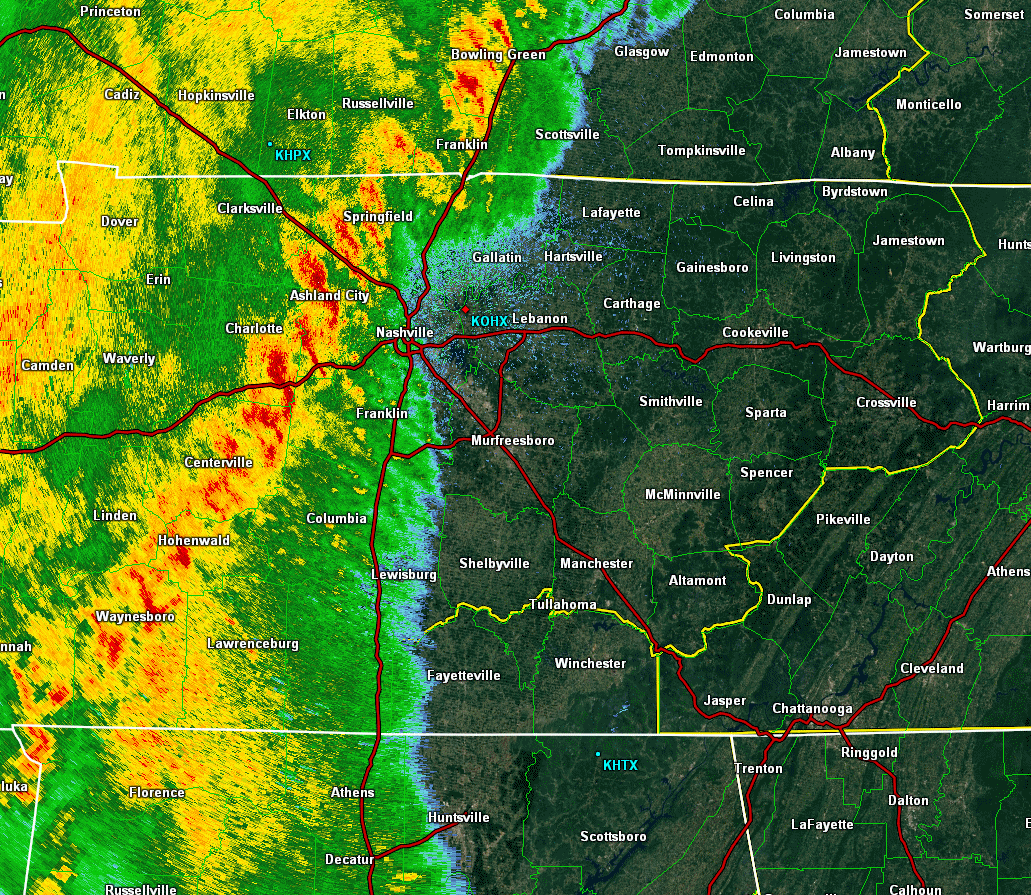
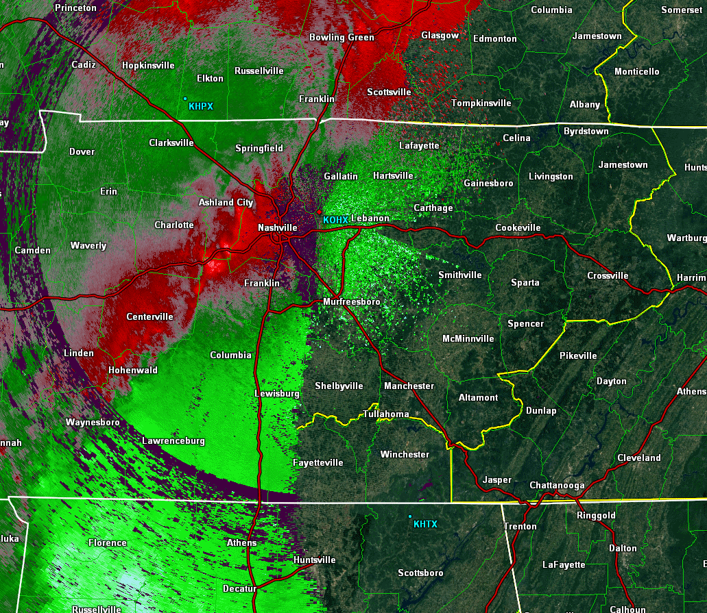
| Radar | |
| OHX Radar Base Reflectivity Loop 3AM - 8AM | OHX Radar Storm Relative Velocity Loop 3AM - 8AM |

