Record setting heat is expected over the next several days from the Intermountain West through the northern Plains. Furthermore, fire weather concerns increase with dry and breezy conditions. Meanwhile, heavy rainfall and severe thunderstorm threats for the Ohio/Tennessee Valleys, central Appalachians and Southeast today. The threat shifts to central Gulf Coast and across central Texas this week. Read More >
Chicago, IL
Weather Forecast Office
|
|
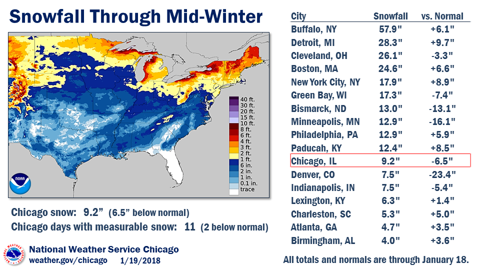
For Rockford, IL, total snowfall through January 18 was 10.8". This is 8.4" below the normal of 19.2" usually seen through mid-January.
For more, please visit our local climate page.
Hazards
Enhanced Hazardous Weather Outlook
Hazardous Weather Outlook
National Briefing
Storm Spotter Training and Seminars
Outlooks
Watch/Warning/Advisory Criteria
Snow Squall Warnings
Local Forecasts
Marine
Aviation
Fire
Text Products
Great Lakes Marine Portal
Lake Michigan Beach Forecast
El Nino
Snow and Ice Probabilities
US Dept of Commerce
National Oceanic and Atmospheric Administration
National Weather Service
Chicago, IL
250 George J Michas Dr.
Romeoville, IL 60446
815-834-1435 8am-8pm
Comments? Questions? Please Contact Us.