Record setting heat is expected over the next several days from the Intermountain West through the northern Plains. Furthermore, fire weather concerns increase with dry and breezy conditions. Meanwhile, heavy rainfall and severe thunderstorm threats for the Ohio/Tennessee Valleys, central Appalachians and Southeast today. The threat shifts to central Gulf Coast and across central Texas this week. Read More >
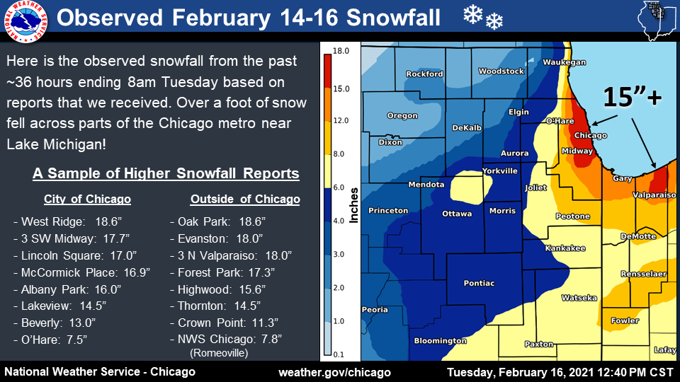
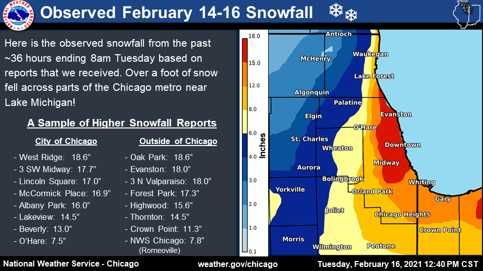
| A strong storm system that brought snow as far south as the Gulf Coast of Texas crossed the Great Lakes region February 15th into the morning of the 16th. Though northern Illinois was on the northwest extent of the main axis of heavy snow with this system, lake-effect and lake-enhanced snow resulted in significant snow totals along and near Lake Michigan in Illinois and Indiana, where amounts in excess of 12" were common, with isolated pockets of up to 18". A substantial snowfall gradient was centered roughly along the I-294 corridor in Cook County, with a difference of up to 10 inches over as little as 5 miles (7.1" in Elmhurst and 18.2" in Oak Park.) |
|
Fast Facts
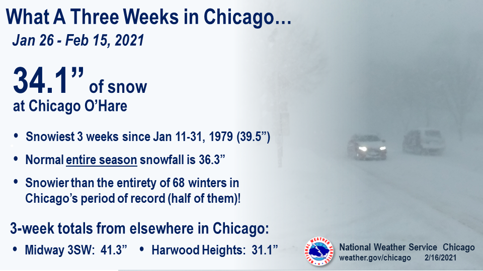 |
| Three week stretch of snowfall in Chicago. |
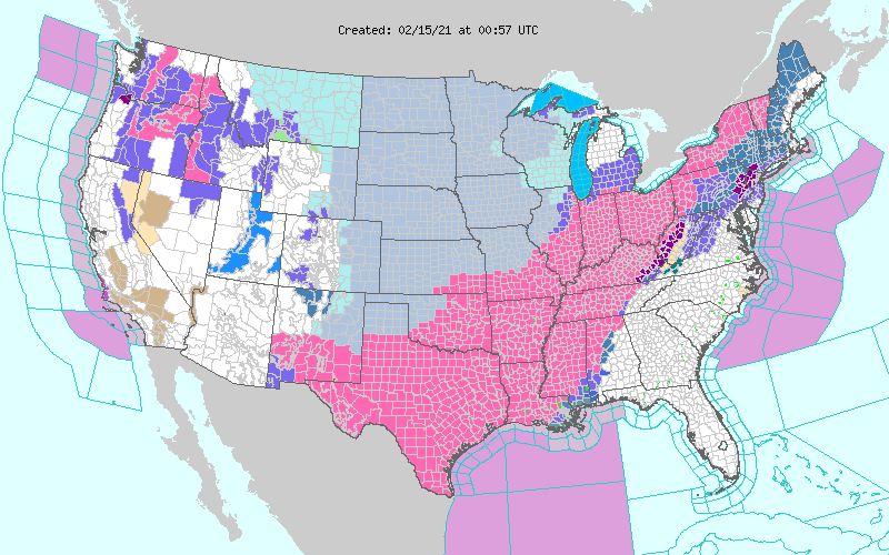 |
| NWS Warnings, Watches, and Advisories. |
Snow Totals
|
|
|
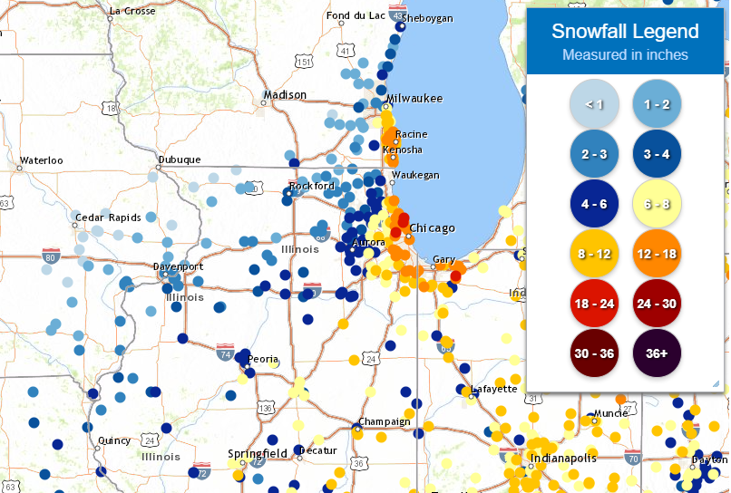
| Storm total snowfall from the evening of 2/14 through ~8am 2/16. | Storm total snowfall from the evening of 2/14 through ~8am 2/16, zoomed into the Chicago metro. |
 |
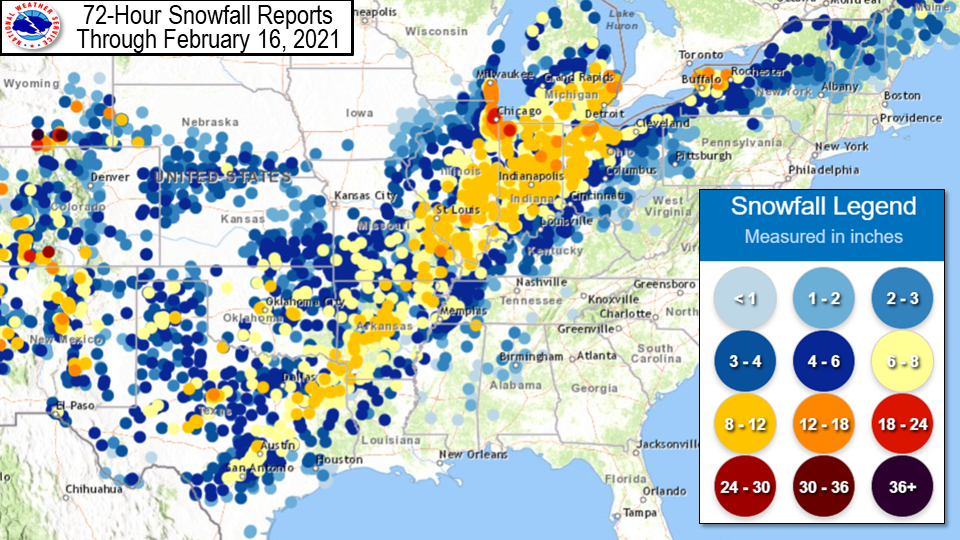 |
| Regional Snowfall Reports | National Snowfall Reports |
Public Information Statement
National Weather Service Chicago IL
530 PM CST Tue Feb 16 2021

...Observed Snow Accumulations for 2/14-2/16...

The following are observed snowfall totals from the evening of Sunday,
February 14 through the morning of Tuesday, February 16 as relayed to
the National Weather Service from a variety of sources.


...SNOWFALL REPORTS...

Location                     Amount    Time/Date       Provider

...Illinois...

...Boone County...
Caledonia 1.4 W              1.9 in    0700 AM 02/16   COCORAHS
Timberlane 1 SW              1.8 in    0700 AM 02/16   COCORAHS
Capron                       1.5 in    0700 AM 02/16   COCORAHS

...Cook County...
Chicago - West Ridge         18.6 in   0700 AM 02/16   COCORAHS
Oak Park 1 NNE               18.2 in   0650 AM 02/16   COCORAHS
Evanston                     18.0 in   0700 AM 02/16   Trained Spotter
1 ENE Bridgeview             17.7 in   0600 AM 02/16   Official NWS Obs
Forest Park 1 ENE            17.3 in   0700 AM 02/16   COCORAHS
Lincoln Square - Chicago     17.0 in   0650 AM 02/16   Public
1 N Douglas - Chicago        16.9 in   0648 AM 02/16   Trained Spotter
Chicago - West Ridge         16.5 in   0700 AM 02/16   COCORAHS
2 WNW Wilmette               16.0 in   0813 AM 02/16   Public
Albany Park - Chicago        16.0 in   0600 AM 02/16   Public
Bridgeview 1 WNW             15.5 in   0730 AM 02/16   COCORAHS
Harwood Heights              15.0 in   0700 AM 02/16   COCORAHS
Thornton                     14.5 in   0810 AM 02/16   Public
Oak Lawn                     14.5 in   0715 AM 02/16   Public
1 E Lakeview - Chicago       14.5 in   0650 AM 02/16   Public
Homewood                     14.0 in   0700 AM 02/16   COCORAHS
1 N Lynwood                  13.6 in   1100 AM 02/16   CO-OP Observer
Oak Lawn 1 WSW               13.4 in   0700 AM 02/16   COCORAHS
Beverly - Chicago            13.0 in   0835 AM 02/16   Public
Chicago Ridge                13.0 in   0700 AM 02/16   COCORAHS
Northbrook                   9.7 in    0600 AM 02/16   Trained Spotter
Oak Forest 1 NNW             9.6 in    0700 AM 02/16   COCORAHS
Park Forest                  9.5 in    0500 AM 02/16   COOP
La Grange Park 1 SSW         8.5 in    0700 AM 02/16   COCORAHS
Park Ridge 1 SSW             8.4 in    0700 AM 02/16   COCORAHS
Palos Park 2 WSW             7.5 in    0700 AM 02/16   COCORAHS
Ohare Airport                7.5 in    0600 AM 02/16   Official NWS Obs
Franklin Park 0.5 SSE        6.6 in    0800 AM 02/16   COCORAHS
Mount Prospect               6.5 in    0800 AM 02/16   Trained Spotter
Schaumburg 2 E               6.4 in    0700 AM 02/16   COCORAHS
Elk Grove Village 2 WSW      5.6 in    0650 AM 02/16   COCORAHS
2 NNE Palatine               5.5 in    0910 AM 02/16   Trained Spotter
Roselle 1 NNW                5.1 in    0500 AM 02/16   COCORAHS
Palatine 1 E                 4.3 in    0915 AM 02/16   COCORAHS
Hoffman Estates              4.0 in    0700 AM 02/16   COCORAHS
Barrington                   3.9 in    0800 AM 02/16   COOP

...De Kalb County...
Sycamore                     2.6 in    0700 AM 02/16   COCORAHS
Cortland                     2.5 in    0700 AM 02/16   COCORAHS
DeKalb                       2.5 in    0700 AM 02/16   COCORAHS

...DuPage County...
Lombard                      8.2 in    0700 AM 02/16   COCORAHS
Elmhurst 2 SE                7.1 in    0700 AM 02/16   COCORAHS
Glen Ellyn 1 SW              6.6 in    0530 AM 02/16   COCORAHS
Roselle 1 ESE                6.0 in    0811 AM 02/16   COCORAHS
Glen Ellyn 1 W               6.0 in    0700 AM 02/16   COCORAHS
Aurora 4 NE                  5.0 in    1000 AM 02/16   COCORAHS
Naperville 3 SE              5.0 in    0700 AM 02/16   COCORAHS
Naperville                   5.0 in    0600 AM 02/16   COCORAHS
West Chicago 4 SE            4.8 in    0819 AM 02/16   COCORAHS
Bolingbrook 3 NE             4.7 in    0700 AM 02/16   COCORAHS
Aurora 4 ESE                 4.5 in    0700 AM 02/16   COCORAHS
West Chicago 4 NNE           3.0 in    0700 AM 02/16   COCORAHS

...Ford County...
Paxton                       6.5 in    1200 PM 02/16   Emergency Mngr

...Grundy County...
Carbon Hill 3 NW             5.5 in    0800 AM 02/16   COCORAHS
Coal City 4 NNW              4.7 in    0700 AM 02/16   UCOOP
Morris 2 W                   4.2 in    0700 AM 02/16   COCORAHS
Morris 1 NW                  4.0 in    0800 AM 02/16   COOP

...Iroquois County...
Chebanse                     7.2 in    1000 AM 02/16   COCORAHS
Ashkum 6 E                   4.9 in    0700 AM 02/16   COCORAHS

...Kane County...
St. Charles                  5.3 in    0830 AM 02/16   Trained Spotter
Geneva 4 WSW                 5.3 in    0700 AM 02/16   COCORAHS
Elgin 3 W                    4.8 in    0700 AM 02/16   COCORAHS
Sugar Grove 1 NNW            4.2 in    0700 AM 02/16   COCORAHS
Aurora 3 WSW                 4.1 in    0800 AM 02/16   COCORAHS
Geneva 1 SSW                 3.9 in    0730 AM 02/16   COCORAHS
Batavia                      3.9 in    0600 AM 02/16   COCORAHS
North Aurora 1 ENE           3.8 in    0630 AM 02/16   COCORAHS
Geneva                       3.2 in    0700 AM 02/16   COCORAHS
Sleepy Hollow 1 W            2.5 in    0700 AM 02/16   COCORAHS
Geneva 2 WNW                 2.4 in    0700 AM 02/16   COCORAHS
Campton Hills 3 NNE          2.0 in    0700 AM 02/16   COCORAHS

...Kankakee County...
St. Anne                     7.3 in    0700 AM 02/16   COOP

...Kendall County...
Boulder Hill 1 NNE           5.2 in    0700 AM 02/16   COCORAHS
Oswego 1 SSE                 5.0 in    0830 AM 02/16   COCORAHS
Plainfield 4 SW              4.2 in    0700 AM 02/16   COCORAHS

...La Salle County...
Ottawa                       5.9 in    0800 AM 02/16   Public
Streator 1 WSW               4.8 in    0700 AM 02/16   COCORAHS
Mendota 1 SE                 4.5 in    0700 AM 02/16   COOP
Peru 1 NNE                   4.0 in    0700 AM 02/16   COCORAHS
Earlville 3 S                3.0 in    0600 AM 02/16   COOP

...Lake County...
Highwood                     15.6 in   0700 AM 02/16   COCORAHS
Bannockburn                  8.3 in    0700 AM 02/16   COCORAHS
Riverwoods 1 NE              6.2 in    0800 AM 02/16   COCORAHS
Buffalo Grove 2 N            5.4 in    0700 AM 02/16   COCORAHS
Forest Lake 1 SSW            4.7 in    0700 AM 02/16   UCOOP
Mundelein 4 WSW              4.1 in    0700 AM 02/16   COOP
Grandwood Park 1 SE          4.0 in    0600 AM 02/16   COCORAHS
Mundelein 1 NNE              3.9 in    0800 AM 02/16   COCORAHS
Long Lake                    3.0 in    0800 AM 02/16   COCORAHS
Lindenhurst 1 NNW            2.9 in    0700 AM 02/16   COCORAHS
Fox Lake Hills               2.2 in    0700 AM 02/16   COCORAHS

...Lee County...
Sublette 3 WNW               2.5 in    0730 AM 02/16   COCORAHS
Dixon                        2.0 in    0800 AM 02/16   COOP
Nelson 3 NNW                 2.0 in    0800 AM 02/16   COCORAHS
Amboy 1 WSW                  2.0 in    0621 AM 02/16   COCORAHS
Ashton                       1.7 in    0700 AM 02/16   COCORAHS

...Livingston County...
Chatsworth                   9.0 in    0800 AM 02/16   CO-OP Observer
Dwight                       8.0 in    0700 AM 02/16   COOP

...McHenry County...
McHenry 1 ENE                2.5 in    0900 AM 02/16   COCORAHS
Woodstock 4 SW               2.5 in    0800 AM 02/16   COCORAHS
Crystal Lake 1 WSW           2.5 in    0700 AM 02/16   COCORAHS
Huntley                      2.2 in    0700 AM 02/16   COCORAHS
Marengo                      2.1 in    0700 AM 02/16   COCORAHS
Richmond                     2.0 in    1025 AM 02/16   Dept of Highways
Bull Valley 2 WNW            2.0 in    0800 AM 02/16   COCORAHS
Harvard                      2.0 in    0700 AM 02/16   COOP
Hebron 2 WSW                 1.5 in    0700 AM 02/16   UCOOP
Woodstock 5 NW               1.4 in    0700 AM 02/16   COOP

...Will County...
Crete 3 ENE                  11.0 in   0700 AM 02/16   COCORAHS
Crete 3 E                    10.5 in   0700 AM 02/16   COCORAHS
Monee 5 SE                   8.3 in    0800 AM 02/16   COCORAHS
Lockport 2 SE                8.2 in    0700 AM 02/16   COCORAHS
Mokena 1 W                   8.1 in    0700 AM 02/16   COCORAHS
Mokena 2 WSW                 7.8 in    0700 AM 02/16   COCORAHS
NWS Chicago-Romeoville       7.8 in    0600 AM 02/16   Official NWS Obs
Peotone                      7.4 in    0700 AM 02/16   COOP
Manhattan                    7.2 in    0300 AM 02/16   COCORAHS
Manhattan 5 ENE              6.9 in    0800 AM 02/16   COOP
Joliet                       6.8 in    0630 AM 02/16   Trained Spotter
Homer Glen 1 NNE             6.7 in    0700 AM 02/16   COCORAHS
Naperville 4 SE              6.5 in    0940 AM 02/16   COCORAHS
Joliet 2 N                   4.4 in    0700 AM 02/16   UCOOP

...Winnebago County...
Rockford Airport             3.0 in    0600 AM 02/16   Official NWS Obs
Rockford 2 ENE               2.0 in    0900 AM 02/16   COCORAHS

...Indiana...

...Jasper County...
Remington                    9.5 in    0800 AM 02/16   COCORAHS
Rensselaer 2 SW              9.5 in    0730 AM 02/16   COOP
Collegeville                 9.2 in    0600 AM 02/16   COCORAHS
DeMotte                      8.2 in    0800 AM 02/16   COCORAHS
DeMotte                      7.8 in    0600 AM 02/16   COCORAHS
Roselawn 3 ENE               7.0 in    0700 AM 02/16   COCORAHS

...Lake County...
St. John 3 SSE               14.4 in   0700 AM 02/16   COCORAHS
Gary 5 ENE                   13.8 in   0700 AM 02/16   COCORAHS
Munster 1.5 NNW              12.3 in   0759 AM 02/16   COCORAHS
Crown Point                  11.3 in   0700 AM 02/16   Trained Spotter
St. John                     11.3 in   0600 AM 02/16   COCORAHS
Crown Point 2 NNE            10.9 in   0600 AM 02/16   COCORAHS

...Newton County...
Mount Ayr 2 NNE              5.3 in    0830 AM 02/16   COCORAHS

...Porter County...
3 N Valparaiso               18.0 in   0742 AM 02/16   Trained Spotter
Valparaiso 1 N               15.6 in   0700 AM 02/16   COCORAHS
Chesterton 4 ESE             15.0 in   0700 AM 02/16   COCORAHS
Chesterton 2 E               14.2 in   0630 AM 02/16   COCORAHS
Porter                       13.7 in   0730 AM 02/16   COCORAHS
Ogden Dunes                  11.3 in   0620 AM 02/16   COCORAHS
Lakes of the Four Seasons    11.0 in   0830 AM 02/16   COCORAHS
Boone Grove 2 WNW            8.5 in    0730 AM 02/16   COCORAHS
Valparaiso 4 SW              5.1 in    0600 AM 02/16   COCORAHS
Boone Grove 4 NNE            5.0 in    0630 AM 02/16   COCORAHS

Observations are collected from a variety of sources with varying
equipment and exposures. We thank all volunteer weather observers
for their dedication. Not all data listed are considered official.

$$
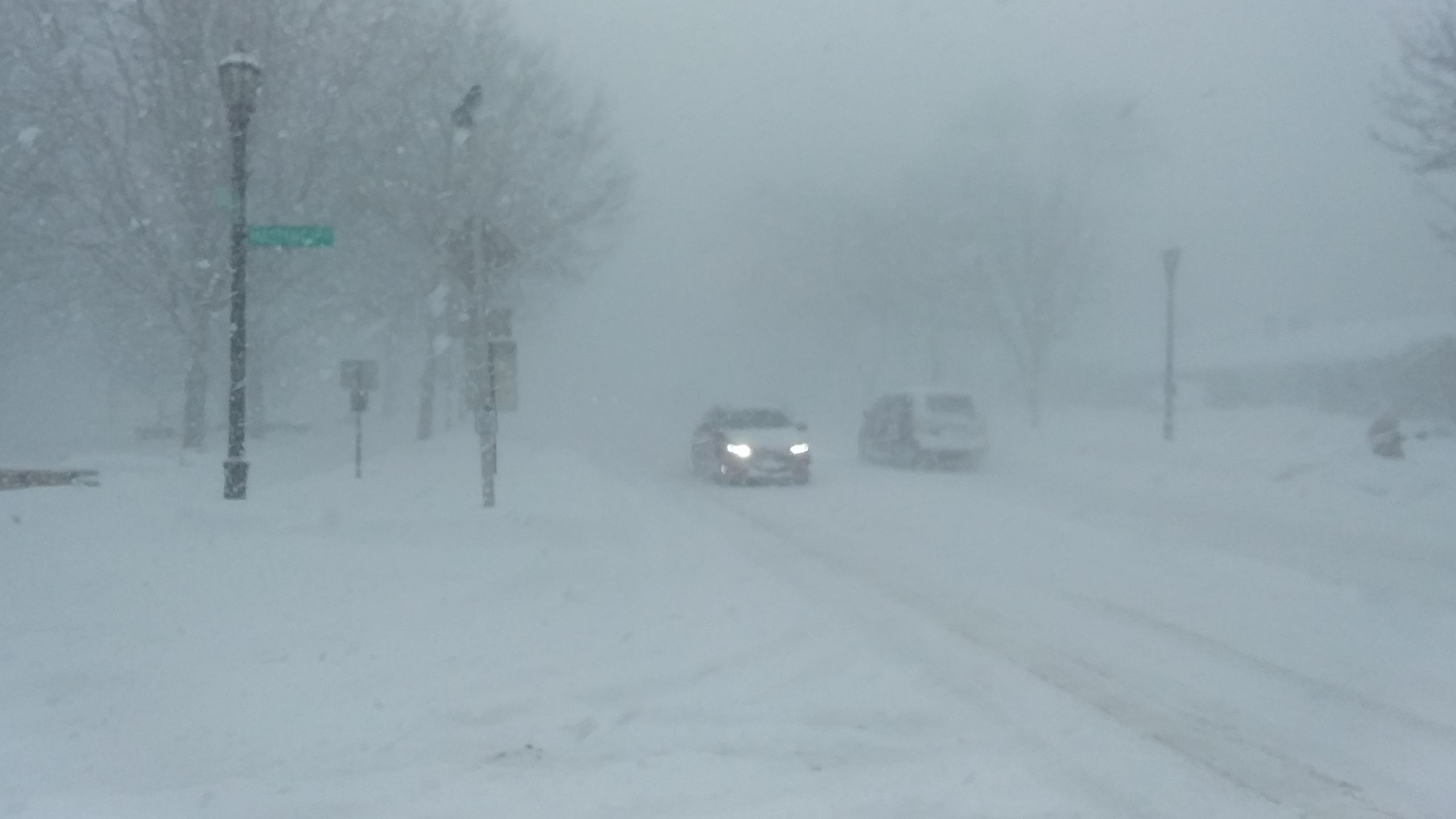
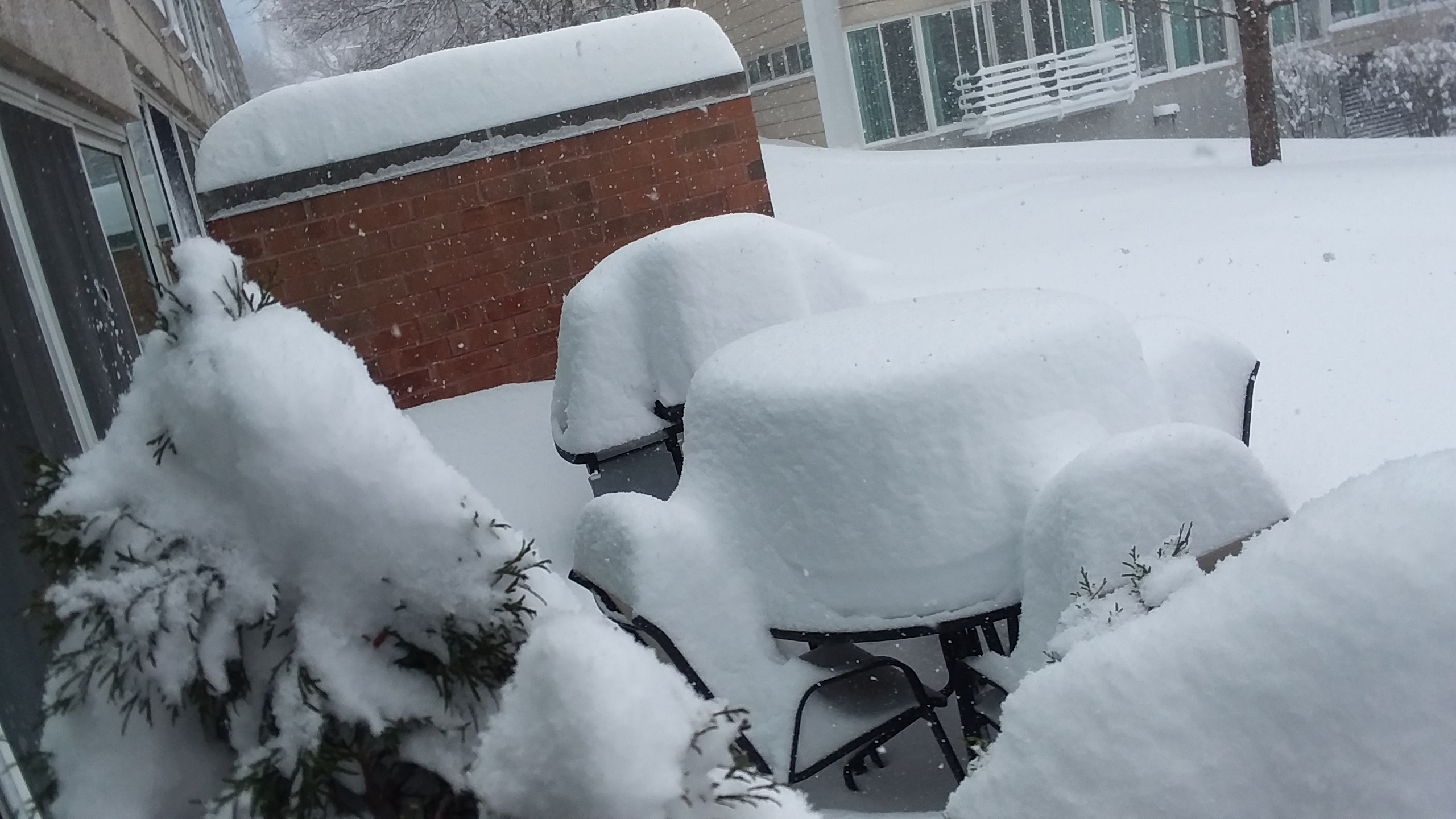
Photos
 |
 |
 |
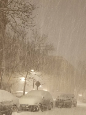
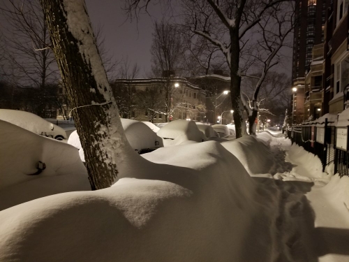
| Evanston. Photo courtesy of Rick DiMaio. | Evanston. Photo courtesy of Rick DiMaio. | Glen Ellyn. Photo courtesy of Amy Crouch. |
 |
 |
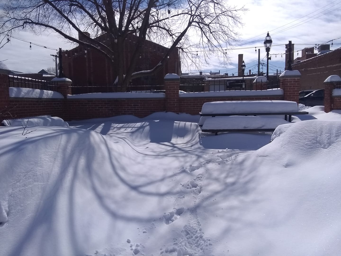
| Chicago (Uptown/Edgewater Area). Photo courtesy of Alek Haselhorst. | |
Radar
.gif) |
| Radar loop from 6 pm February 14 through 12 am February 16. (courtesy of NWS Central Illinois) |
Meteorology
Much of this is courtesy of NWS Central Illinois.
.gif) |
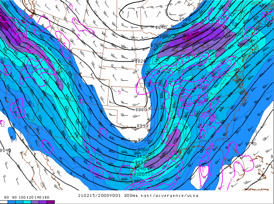 |
| Infrared satellite loop showing the storm mature as it digs into the Southern Plains and then tracks our way to the northeast. Also note the widespread cold air over Canada into the Midwest detected by the infrared satellite imagery. | 300 mb map analysis at 2 p.m. on February 15, as the weather system was rapidly strengthening as approaching. Basically the entire state of Illinois was within an exceptionally favorable zone for strong lift. |
 |
Media use of NWS Web News Stories is encouraged! Additional recaps can be found on the NWS Chicago Science & Past Events Page. |
|