
Record setting heat is expected over the next several days from the Intermountain West through the northern Plains. Furthermore, fire weather concerns increase with dry and breezy conditions. Meanwhile, heavy rainfall and severe thunderstorm threats for the Ohio/Tennessee Valleys, central Appalachians and Southeast today. The threat shifts to central Gulf Coast and across central Texas this week. Read More >
Overview
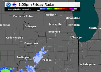
Several rounds of thunderstorms producing heavy rainfall occurred from the evening of August 31st through the early morning of September 2nd. The most significant rainfall amounts occurred the evening of September 1st through the early morning of September 2nd over far northern Illinois. Additional heavy rainfall is expected late Sunday afternoon through at least Monday morning, especially into portions of northwest and north central Illinois. Finally, there was a very isolated area of wind damage over parts of the far northwest side of Chicago during the Saturday morning thunderstorms.
Fast Facts
Radar:
Regional Radar Loop
 |
| Radar Loop from 7 pm Aug. 31 to 11:30 pm Sept 3 |
Storm Reports
PRELIMINARY LOCAL STORM REPORT...SUMMARY
NATIONAL WEATHER SERVICE CHICAGO/ROMEOVILLE IL
112 PM CDT SUN SEP 2 2018

..TIME...   ...EVENT...      ...CITY LOCATION...     ...LAT.LON...
..DATE...   ....MAG....      ..COUNTY LOCATION..ST.. ...SOURCE....
            ..REMARKS..

0846 AM     HEAVY RAIN       1 E ROCKFORD            42.27N 89.04W
09/02/2018  M2.00 INCH       WINNEBAGO          IL   TRAINED SPOTTER

            12 HOUR TOTAL.

0846 AM     HEAVY RAIN       4 SSE LOVES PARK        42.28N 88.97W
09/02/2018  M2.95 INCH       WINNEBAGO          IL   TRAINED SPOTTER

            24 HOUR TOTAL NEAR TULIP AND TRAVERTINE.

0800 AM     HEAVY RAIN       BULL VALLEY             42.31N 88.35W
09/02/2018  M4.16 INCH       MCHENRY            IL   COCORAHS

            24 HOUR RAIN TOTAL. FIELDS FLOODED WITH ESTIMATED 6-8
            INCHES STANDING WATER.

0753 AM     HEAVY RAIN       LIBERTYVILLE            42.28N 87.97W
09/02/2018  M2.28 INCH       LAKE               IL   PUBLIC

            36 HOUR RAINFALL AMOUNT RELAYED VIA TWITTER.

0740 AM     HEAVY RAIN       HUNTLEY                 42.17N 88.42W
09/02/2018  M3.15 INCH       MCHENRY            IL   TRAINED SPOTTER

            RAINFALL TOTAL SINCE EARLY SATURDAY MORNING.

0954 PM     HEAVY RAIN       LIBERTYVILLE            42.28N 87.97W
09/01/2018  M0.51 INCH       LAKE               IL   EMERGENCY MNGR

            RAINFALL OF 0.51 INCHES WAS MEASURED IN 8 MINUTES.

0815 AM     TSTM WND DMG     5 N FOREST PARK         41.94N 87.82W
09/01/2018                   COOK               IL   BROADCAST MEDIA

            SEVERAL LARGE TREES AND TREE LIMBS DOWN IN A VERY
            LOCALIZED AREA OF THE BELMONT HEIGHTS NEIGHBORHOOD ON THE
            FAR NORTHWEST SIDE OF CHICAGO. MOST OF THE DAMAGE FOCUSED
            NEAR THE 3500 BLOCK OF NORTH OPAL AVENUE. TIME ESTIMATED
            BY RADAR.


&&

$$
Rain Reports
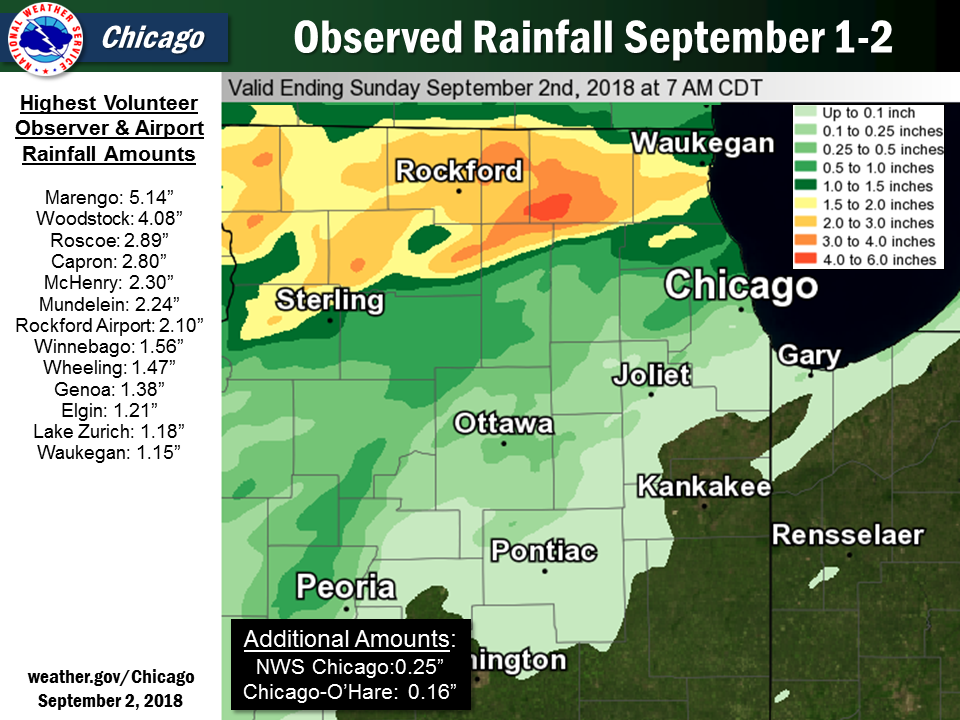 |
| Observed Rainfall September 1-2 |
Public Information Statement
National Weather Service Chicago IL
1043 AM CDT Sun Sep 02 2018

...Morning Rainfall Roundup...

   The following are rain amounts for the previous 24-hours
   as measured in the morning by NWS Cooperative Observers
   and CoCoRaHS observers.
   Observations are usually taken between 6 AND 8 AM.

   24-hour rainfall amounts
       for Sunday(09/02/18)...


Illinois                                       Rain
  Location (County):                           fall (inches)

  Marengo (McHenry)............................5.14
  Woodstock (McHenry)..........................4.08
  Roscoe 2SE (Winnebago).......................2.89
  Capron (Boone)...............................2.80
  McHenry (McHenry)............................2.30
  Mundelein (Lake).............................2.24
  Rockford (Winnebago).........................2.10
  Winnebago 1SE (Winnebago)....................1.56
  Wheeling (Cook)..............................1.47
  Genoa (De Kalb)..............................1.38
  Elgin (Kane).................................1.21
  Lake Zurich (Lake)...........................1.18
  Waukegan (Lake)..............................1.15
  Elgin (Kane).................................0.78
  Paw Paw (Lee)................................0.78
  Botanic Gardens (Cook).......................0.74
  Steward (Lee)................................0.52
  Westmont (Du Page)...........................0.46
  Shabbona (De Kalb)...........................0.43
  Aurora (Kane)................................0.37
  Batavia (Kane)...............................0.35
  West Chicago (Du Page).......................0.35
  Elburn (Kane)................................0.35
  Rochelle (Ogle)..............................0.33
  De Kalb (De Kalb)............................0.32
  Mendota (La Salle)...........................0.29
  Dekalb (De Kalb).............................0.26
  Romeoville (Will)............................0.25
  Aurora (Kane)................................0.24
  Willow Springs (Cook)........................0.20
  Morris (Grundy)..............................0.18
  Romeoville (Will)............................0.17
  Marseilles (La Salle)........................0.16
  Ohare (Cook).................................0.16
  Joliet 2n (Will).............................0.13
  Midway Coop (Cook)...........................0.13
  Dwight (Livingston)..........................0.10
  Peru (La Salle)..............................0.10

$$
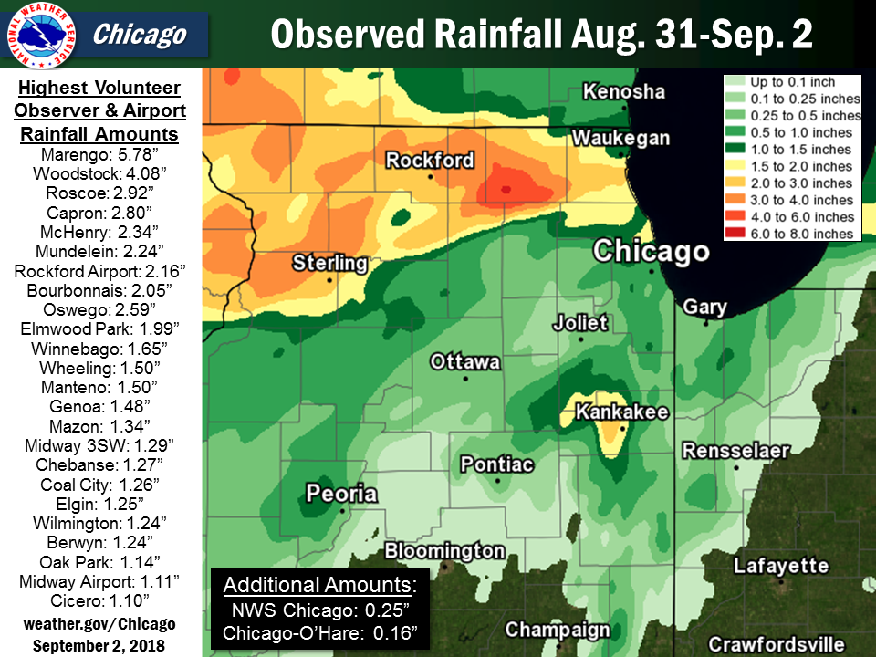 |
| Observed Rainfall August 31-September 2 |
Public Information Statement
National Weather Service Chicago/Romeoville IL
1035 AM CDT Sun Sep 02 2018

...2-Day Rainfall Round-up...

The following are rainfall amounts for the previous 2 days as
measured in the morning by NWS Cooperative observers and CoCoRaHS
observers. Observations are usually taken between 6 AM and 8 AM.

  2-day rain totals for Sunday (09/02/18)
     as of 10:25 AM CDT

ILLINOIS                                 2-Day rainfall
  Location (County):                         Amt(inches) reports

  Marengo (McHenry)............................5.78     (2)
  Woodstock (McHenry)..........................4.08     (1)
  Roscoe 2SE (Winnebago).......................2.92     (2)
  Capron (Boone)...............................2.80     (2)
  McHenry (McHenry)............................2.34     (2)
  Mundelein (Lake).............................2.24     (1)
  Rockford (Winnebago).........................2.16     (2)
  Bourbonnais (Kankakee).......................2.05     (1)
  Elmwood Park 1ESE (Cook).....................1.99     (1)
  Elmwood Park 1NNW (Cook).....................1.70     (1)
  Winnebago 1SE (Winnebago)....................1.65     (2)
  Wheeling (Cook)..............................1.50     (2)
  Manteno 2NW (Kankakee).......................1.50     (1)
  Genoa (De Kalb)..............................1.48     (2)
  Mazon 0.5ENE (Grundy)........................1.34     (1)
  Midway Coop (Cook)...........................1.29     (2)
  Chebanse (Kankakee)..........................1.27     (1)
  Coal City (Grundy)...........................1.26     (1)
  Elgin (Kane).................................1.25     (2)
  Wilmington 3SE (Will)........................1.24     (1)
  Berwyn 1NW (Cook)............................1.24     (1)
  Oak Park 1SW (Cook)..........................1.21     (1)
  Lake Zurich (Lake)...........................1.18     (1)
  Dwight 4NNW (Grundy).........................1.18     (1)
  Waukegan (Lake)..............................1.15     (1)
  Oak Park 1NNE (Cook).........................1.14     (1)
  Midway (Cook)................................1.11     (2)
  Oak Park 2S (Cook)...........................1.10     (1)
  Cicero 2SSW (Cook)...........................1.10     (1)
  Dixon 3NNW (Lee).............................1.04     (1)
  Morris 6ESE (Grundy).........................0.94     (1)
  Oak Lawn 2WNW (Cook).........................0.92     (1)
  Oak Lawn 1N (Cook)...........................0.91     (1)
  Flossmoor (Cook).............................0.90     (1)
  Bridgeview 1NNW (Cook).......................0.90     (1)
  Oak Lawn 2NW (Cook)..........................0.89     (1)
  Botanic Gardens (Cook).......................0.87     (2)
  Paw Paw (Lee)................................0.86     (2)
  Coal City 4NNW (Grundy)......................0.82     (2)
  Kankakee (Kankakee)..........................0.82     (1)
  Chicago Ridge (Cook).........................0.81     (1)
  Carbon Hill 3.1N (Grundy)....................0.79     (1)
  Harwood Heights (Cook).......................0.79     (1)
  Worth (Cook).................................0.79     (1)
  Glen Ellyn (Du Page).........................0.79     (1)
  Elgin (Kane).................................0.78     (1)
  Coal City 3N (Grundy)........................0.75     (1)
  Midlothian (Cook)............................0.75     (1)
  Homewood (Cook)..............................0.67     (1)
  Flossmoor 1ESE (Cook)........................0.67     (1)
  Alsip (Cook).................................0.67     (1)
  Park Forest 1NNE (Cook)......................0.66     (1)
  Park Ridge (Cook)............................0.61     (1)
  Park Forest (Cook)...........................0.60     (1)
  Steward (Lee)................................0.59     (2)
  Peotone (Will)...............................0.58     (2)
  Oak Lawn 2SE (Cook)..........................0.57     (1)
  Oak Lawn (Cook)..............................0.56     (1)
  Shabbona (De Kalb)...........................0.55     (2)
  Chicago 6ESE (Cook)..........................0.55     (1)
  Naperville 1NW (Du Page).....................0.54     (1)
  Watseka 6.9WNW (Iroquois)....................0.53     (1)
  Manhattan 2SE (Will).........................0.51     (1)
  Riverwoods (Lake)............................0.51     (1)
  Manhattan 1ESE (Will)........................0.49     (1)
  Midlothian 1SE (Cook)........................0.49     (1)
  Ravenswood Manor (Cook)......................0.47     (1)
  Westmont (Du Page)...........................0.46     (1)
  De Kalb (De Kalb)............................0.46     (2)
  Herscher 3E (Kankakee).......................0.43     (1)
  Rochelle (Ogle)..............................0.39     (2)
  Manhattan (Will).............................0.39     (2)
  Lake Forest 2NNE (Lake)......................0.39     (1)
  Manhattan 5ENE (Will)........................0.37     (1)
  Bannockburn (Lake)...........................0.37     (1)
  Aurora (Kane)................................0.37     (2)
  Mendota (La Salle)...........................0.36     (2)
  Countryside 1ENE (Cook)......................0.35     (1)
  Park Ridge 1WNW (Cook).......................0.35     (1)
  Elburn (Kane)................................0.35     (1)
  West Chicago (Du Page).......................0.35     (1)
  Batavia (Kane)...............................0.35     (1)
  Pontiac 1SE (Livingston).....................0.34     (1)
  Morris 2SSE (Grundy).........................0.34     (1)
  Lincolnwood 2E (Cook)........................0.34     (1)
  Morris (Grundy)..............................0.34     (2)
  Ashkum 5.6E (Iroquois).......................0.33     (1)
  Winnetka 1ESE (Cook).........................0.33     (1)
  Rogers Park 2SW (Cook).......................0.32     (1)
  Evanston 1N (Cook)...........................0.31     (1)
  Dekalb (De Kalb).............................0.31     (2)
  Lansing (Cook)...............................0.30     (2)
  Homer Glen 1ENE (Will).......................0.30     (1)
  New Lenox 2SE (Will).........................0.29     (1)
  New Lenox 3ENE (Will)........................0.27     (1)
  Palos Park 1SW (Cook)........................0.27     (1)
  Paxton (Ford)................................0.26     (2)
  Monee (Will).................................0.25     (1)
  Romeoville (Will)............................0.25     (2)

INDIANA                                    2-Day rainfall
  Location (County):                         Amt(inches) reports

  Winfield 1NE (Lake)..........................0.80     (1)
  Portage 1ESE (Porter)........................0.66     (1)
  Valparaiso 2WSW (Porter).....................0.55     (1)
  Crown Point (Lake)...........................0.54     (2)
  Valparaiso 6NW (Porter)......................0.44     (1)
  Valparaiso 2WNW (Porter).....................0.44     (1)
  Hobart 2E (Lake).............................0.44     (1)
  Valparaiso 6WSW (Porter).....................0.43     (1)
  (w9mal)Merrillville 2NNW (Lake)..............0.43     (1)
  Valparaiso 2NW (Porter)......................0.39     (1)
  Portage 3E (Porter)..........................0.37     (1)
  Hebron 1NE (Porter)..........................0.36     (1)
  Valparaiso 4SW (Porter)......................0.36     (1)
  Porter 1S (Porter)...........................0.35     (1)
  Kentland 2SSE (Newton).......................0.35     (1)
  Schererville 1E (Lake).......................0.33     (1)
  Dyer 1WNW (Lake).............................0.33     (1)
  Valparaiso 2N (Porter).......................0.31     (1)
  De Motte 6S (Jasper).........................0.30     (1)
  Valparaiso 3WSW (Porter).....................0.29     (1)
  Hebron 4NE (Porter)..........................0.28     (1)
  Gary 5ENE (Lake).............................0.27     (1)
  Crown Point 2WSW (Lake)......................0.27     (1)
  Schererville 1E (Lake).......................0.26     (1)
  Fair Oaks 6SW (Newton).......................0.25     (1)
  Munster 2NNW (Lake)..........................0.25     (1)

$$
4-Day Rain Total Map
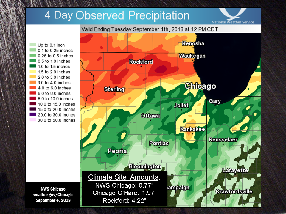 |
| Observed Rainfall from 7 am August 31- 7 am September 4 |
 |
Media use of NWS Web News Stories is encouraged! Please acknowledge the NWS as the source of any news information accessed from this site. |
|

