
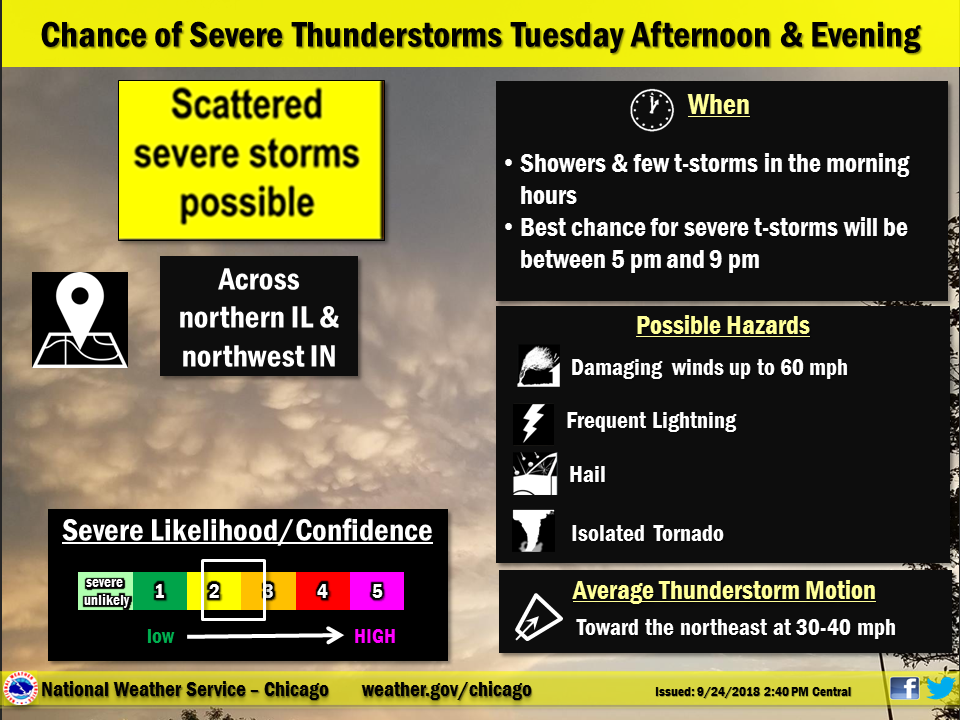
Record setting heat is expected over the next several days from the Intermountain West through the northern Plains. Furthermore, fire weather concerns increase with dry and breezy conditions. Meanwhile, heavy rainfall and severe thunderstorm threats for the Ohio/Tennessee Valleys, central Appalachians and Southeast today. The threat shifts to central Gulf Coast and across central Texas this week. Read More >
Overview
|
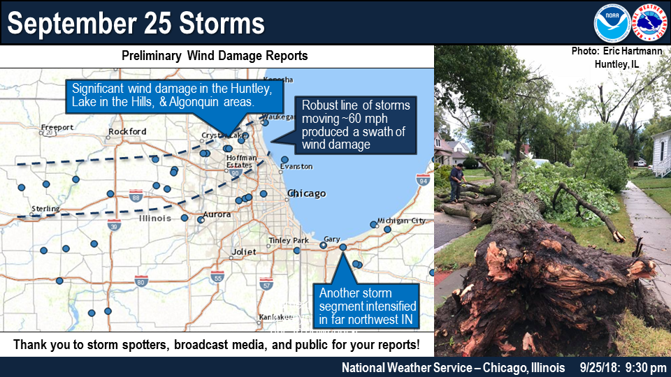
Fast Facts: The first was a line segment through the following counties: Ogle, northern DeKalb, northern Kane, southern McHenry, far northern Cook, and southern Lake. This produced concentrated significant wind damage in Huntley and adjacent areas. A second one moved across far southern Lee County and along the far northern LaSalle County border. This weakened slightly before entering the far southern Chicago metro, but still had 40+ mph wind gusts. Part of this area re-intensified in northwest Indiana across northern Lake and Porter Counties. |
 Event Summary |
Storm Reports
 |
| Huntley, IL. Photo by Eric Hartmann |
PRELIMINARY LOCAL STORM REPORT...SUMMARY
NATIONAL WEATHER SERVICE CHICAGO/ROMEOVILLE IL
1045 PM CDT WED SEP 26 2018
..TIME... ...EVENT... ...CITY LOCATION... ...LAT.LON...
..DATE... ....MAG.... ..COUNTY LOCATION..ST.. ...SOURCE....
..REMARKS..
0335 PM TSTM WND DMG POLO 41.98N 89.58W
09/25/2018 OGLE IL EMERGENCY MNGR
OGLE COUNTY EM REPORTS WIDESPREAD WIND DAMAGE ACROSS
POLO, BUT LIMITED DETAILS AT THIS TIME.
0350 PM TSTM WND DMG OREGON 42.01N 89.34W
09/25/2018 OGLE IL EMERGENCY MNGR
OGLE COUNTY EM REPORTS WIDESPREAD TREE DAMAGE ACROSS
OREGON. NO SPECIFICS OF BRANCH SIZE CURRENTLY AVAILABLE.
0404 PM TSTM WND DMG 9 S WALTON 41.58N 89.42W
09/25/2018 LEE IL LAW ENFORCEMENT
LARGE TREE AND POWER LINE DOWNED ALONG DOWNEY ROAD. TIME
ESTIMATED.
0405 PM TSTM WND DMG 5 E ROCKTON 42.44N 88.96W
09/25/2018 WINNEBAGO IL EMERGENCY MNGR
WINNEBAGO COUNTY EM REPORTS TREE DOWN BLOCKING LEGEND
LAKES DRIVE NORTHEAST OF ROSCOE.
0410 PM TSTM WND DMG ROCHELLE 41.92N 89.06W
09/25/2018 OGLE IL LAW ENFORCEMENT
ROCHELLE PD REPORTS WIDESPREAD TREE DAMAGE ACROSS
ROCHELLE, INCLUDING A BRANCH WHICH FELL ONTO A RESIDENCE
AND CAUSED ROOF DAMAGE.
0416 PM TSTM WND GST 3 SE SUBLETTE 41.61N 89.19W
09/25/2018 E60.00 MPH LEE IL TRAINED SPOTTER
WINDS TO AT LEAST 60 MPH.
0421 PM TSTM WND DMG MENDOTA 41.55N 89.12W
09/25/2018 LA SALLE IL TRAINED SPOTTER
LARGE TREE DOWNED.
0434 PM TSTM WND DMG 2 NNW GENOA 42.12N 88.70W
09/25/2018 DE KALB IL BROADCAST MEDIA
TREE DAMAGE IN THE PINE RIDGE SUBDIVISION. TIME
ESTIMATED.
0438 PM TSTM WND DMG BURLINGTON 42.05N 88.55W
09/25/2018 KANE IL LAW ENFORCEMENT
NUMEROUS LARGE BRANCHED DOWNED. TIME ESTIMATED.
0438 PM TSTM WND GST 1 SSE SYCAMORE 41.97N 88.69W
09/25/2018 E60.00 MPH DE KALB IL TRAINED SPOTTER
SPOTTER REPORTS ESTIMATED 60MPH GUST AND ISOLATED TREE
DAMAGE NEAR SYCAMORE. RELAYED VIA SPOTTER NETWORK.
0440 PM TSTM WND DMG 2 SSW HAMPSHIRE 42.07N 88.54W
09/25/2018 KANE IL EMERGENCY MNGR
KANE COUNTY EM REPORTS MULTIPLE TREES AND POWER LINES
DAMAGED IN THE BURLINGTON AND HAMPSHIRE AREAS.
0444 PM TSTM WND DMG 5 ESE SYCAMORE 41.95N 88.60W
09/25/2018 DE KALB IL AMATEUR RADIO
LARGE TREE BLOCKING COUNTY LINE ROAD NEAR BARBER GREENE
ROAD NORTH OF MAPLE PARK.
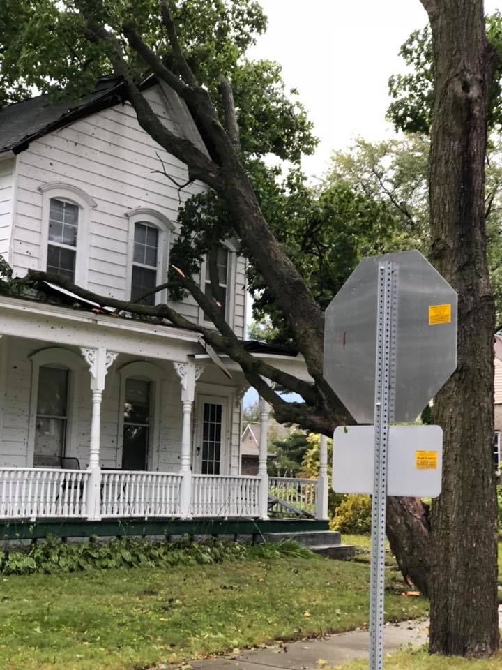
0450 PM TSTM WND DMG HUNTLEY 42.17N 88.42W
09/25/2018 MCHENRY IL EMERGENCY MNGR
MCHENRY CO. EMERGENCY REPORTS ABUNDANT TREE DAMAGE ACROSS
HUNTLEY, LAKE IN THE HILLS, ALGONQUIN AND NEARBY AREAS.
APPROXIMATELY 30000 WITHOUT POWER. HOMES ALSO AFFECTED BY
DOWNED TREES AND BRANCHES.
0450 PM TSTM WND GST HUNTLEY 42.17N 88.42W
09/25/2018 M70.00 MPH MCHENRY IL EMERGENCY MNGR
MCHENRY COUNTY EM RELAYED A REPORT OF MEASURED 70MPH WIND
GUST JUST NORTH OF HUNTLEY. ALSO REPORTS OF POWER LINE
AND TREE DAMAGE IN HUNTLEY.
0455 PM TSTM WND DMG 1 NW ALGONQUIN 42.17N 88.31W
09/25/2018 MCHENRY IL EMERGENCY MNGR
MCHENRY COUNTY EM REPORTS POWER LINE AND TREE DAMAGE IN
THE LAKE IN THE HILLS AND ALGONQUIN AREAS.
0457 PM TSTM WND GST SUGAR GROVE 41.77N 88.46W
09/25/2018 M55.00 MPH KANE IL ASOS
MEASURED AT THE ARR ASOS
0457 PM TSTM WND DMG 1 ENE ALGONQUIN 42.17N 88.28W
09/25/2018 MCHENRY IL AMATEUR RADIO
TREES AND POWERLINES DOWN NEAR ECHO WOODS DR AND RIVER
RD. TIME ESTIMATED BASED ON RADAR.
0458 PM TSTM WND DMG LAKE IN THE HILLS 42.19N 88.32W
09/25/2018 MCHENRY IL LAW ENFORCEMENT
NUMEROUS TREES DOWNED.
0500 PM TSTM WND DMG 2 SSW TONICA 41.19N 89.08W
09/25/2018 LA SALLE IL TRAINED SPOTTER
SPOTTER REPORTS OVERTURNED SEMI ON I-39 NEAR TONICA.
RELAYED VIA SPOTTER NETWORK.
0505 PM TSTM WND DMG 3 NNW BARRINGTON 42.20N 88.14W
09/25/2018 LAKE IL EMERGENCY MNGR
LAKE COUNTY EM REPORTS POWER LINE AND TREE DAMAGE IN
NORTH BARRINGTON NEAR MOHAWK DRIVE AND SIGNAL HILL ROAD.
0505 PM TSTM WND DMG 3 N BARRINGTON 42.20N 88.12W
09/25/2018 LAKE IL EMERGENCY MNGR
TREE BLOCKING ROAD AT CONCORD LANE AND KIMBERLY ROAD.
0505 PM TSTM WND DMG 4 NNE BARRINGTON 42.20N 88.10W
09/25/2018 LAKE IL EMERGENCY MNGR
LAKE COUNTY EM REPORTS POWER LINES DOWN ONTO N OLD RAND
ROAD IN LAKE ZURICH.
0510 PM TSTM WND DMG 2 WSW AURORA 41.76N 88.33W
09/25/2018 KANE IL EMERGENCY MNGR
KANE COUNTY EMA REPORTS LARGE TREES AND POWER LINES
DOWNED ON TO A HOUSE AND CAR NEAR GARFIELD AVE AND
FRANKLIN AVE IN AURORA.
0515 PM TSTM WND DMG 3 SSW LIBERTYVILLE 42.25N 88.00W
09/25/2018 LAKE IL EMERGENCY MNGR
POWER POLE DAMAGED AND TREE LIMBS DOWN ONTO LINES THAT
WERE BURNING.
0516 PM TSTM WND GST LIBERTYVILLE 42.28N 87.97W
09/25/2018 M53.00 MPH LAKE IL TRAINED SPOTTER
SPOTTER REPORTS MEASURED 53 MPH GUST IN LIBERTYVILLE.
RELAYED VIA LAKE COUNTY EM.
0520 PM TSTM WND DMG GURNEE 42.38N 87.94W
09/25/2018 LAKE IL EMERGENCY MNGR
LAKE COUNTY EM REPORTS POWER LINE DAMAGE IN GURNEE. NO
ADDITIONAL DETAILS AT THIS TIME.
0520 PM TSTM WND DMG 3 SSW LIBERTYVILLE 42.25N 88.00W
09/25/2018 LAKE IL EMERGENCY MNGR
LAKE COUNTY EM REPORTS POWER LINE AND TREE DAMAGE ALONG
OLGA ROAD IN MUNDELEIN.
0520 PM TSTM WND DMG 3 SE ADDISON 41.89N 87.97W
09/25/2018 DUPAGE IL EMERGENCY MNGR
BENSONVILLE EM REPORTS 8 IN DIAMETER LIMB DOWN NEAR ST
CHARLES ROAD AND VILLA AVENUE IN VILLA PARK.
0524 PM TSTM WND DMG 4 S ADDISON 41.88N 88.02W
09/25/2018 DUPAGE IL PUBLIC
WINDS TOOK THE TOP OUT OF A RED MAPLE NEAR E. WASHINGTON
AND MAIN ST IN LOMBARD. TRUNK DIAMETER WAS ESTIMATED AT
12 INCHES.
0530 PM MARINE TSTM WIND 5 SSE BEACH PARK 42.36N 87.81W
09/25/2018 M43.00 MPH LAKE IL C-MAN STATION
0531 PM TSTM WND DMG ELMHURST 41.90N 87.94W
09/25/2018 DUPAGE IL PUBLIC
ONE FOOT DIAMETER LIMB DOWNED. TIME ESTIMATED.
0540 PM MARINE TSTM WIND 6 E GLENCOE 42.13N 87.65W
09/25/2018 M43.00 MPH LMZ740 IL BUOY
0540 PM TSTM WND DMG ELMWOOD PARK 41.92N 87.82W
09/25/2018 COOK IL PUBLIC
TREE DOWNED THROUGH A FENCE.
0550 PM MARINE TSTM WIND 4 NE CHICAGO 41.92N 87.57W
09/25/2018 M44.00 MPH LMZ741 IL C-MAN STATION
0629 PM TSTM WND GST LANSING 41.57N 87.55W
09/25/2018 M51.00 MPH COOK IL AWOS
0635 PM TSTM WND GST GARY 41.60N 87.34W
09/25/2018 M46.00 MPH LAKE IN AWOS
0643 PM TSTM WND DMG GARY 41.60N 87.34W
09/25/2018 LAKE IN LAW ENFORCEMENT
TREES AND POWERLINES DOWNED.
0654 PM TSTM WND DMG PORTAGE 41.59N 87.18W
09/25/2018 PORTER IN LAW ENFORCEMENT
NUMEROUS TREES AND POWER LINES DOWNED IN NORTHERN PORTER
COUNTY. THERE WAS AN ESTIMATED 60 MPH WIND GUST IN
PORTAGE FROM A STORM SPOTTER AT THIS TIME.
0700 PM MARINE TSTM WIND 3 NNE TOWN OF PINES 41.73N 86.93W
09/25/2018 M48.00 MPH LMZ745 IN C-MAN STATION
0704 PM TSTM WND DMG 5 SSE BURNS HARBOR 41.55N 87.07W
09/25/2018 PORTER IN TRAINED SPOTTER
TREES DOWN ON MERIDIAN RD NEAR VALPARAISO.
0707 PM TSTM WND DMG 3 E LINCOLN HILLS 41.47N 87.05W
09/25/2018 PORTER IN PUBLIC
LARGE TREE SPLIT ON SOUTHEAST SIDE OF VALPARAISO. TIME
ESTIMATED.
0708 PM TSTM WND GST VALPARAISO 41.48N 87.05W
09/25/2018 M44.00 MPH PORTER IN ASOS
Radar
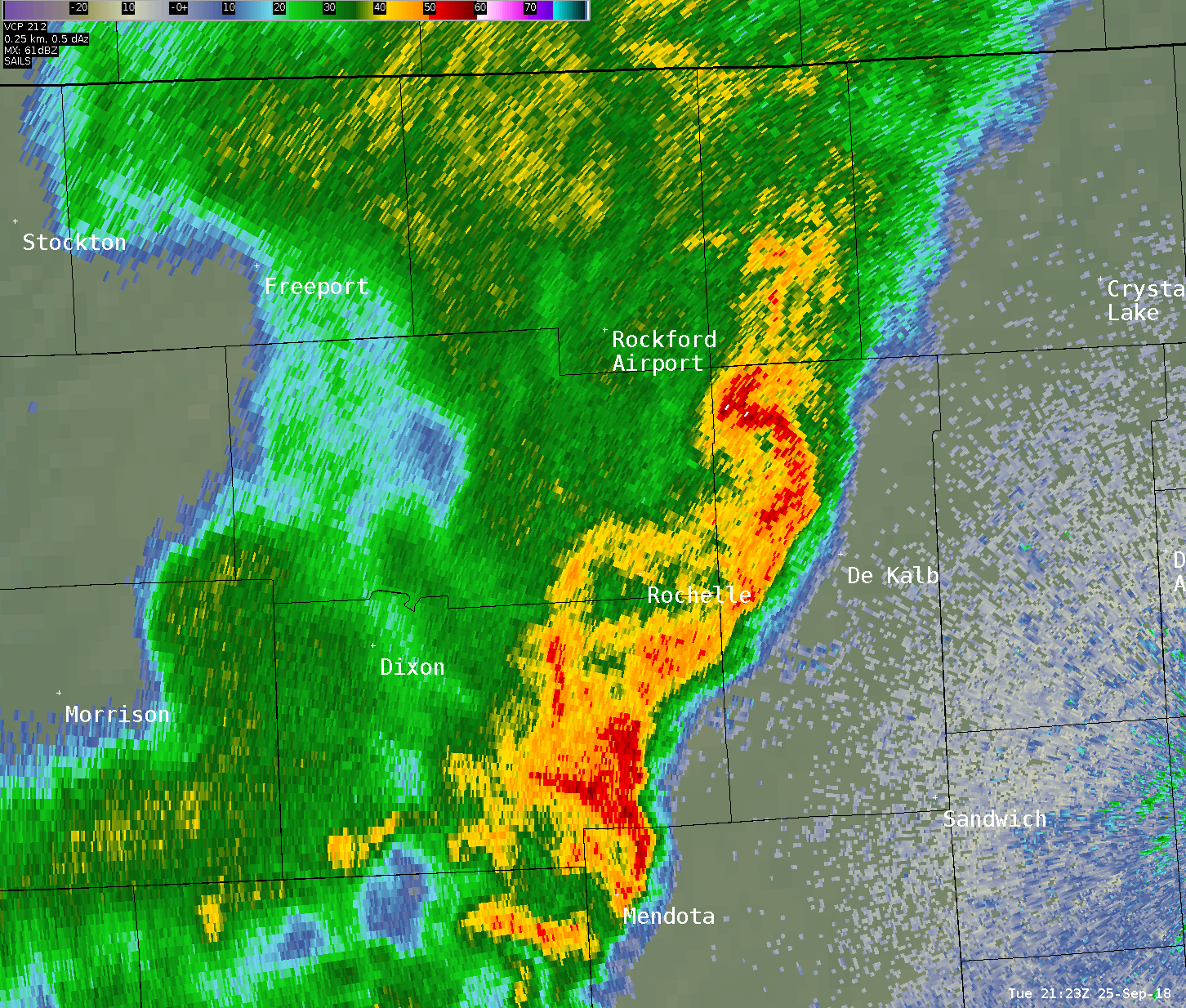 |
| Storm-centric radar loop from 4:30 to 5:30 p.m. |
Rain Reports
Public Information Statement
National Weather Service Chicago IL
1021 AM CDT Wed Sep 26 2018

...Morning Rainfall Roundup...

   The following are rain amounts for the previous 24-hours
   as measured in the morning by NWS Cooperative Observers
   and CoCoRaHS observers.
   Observations are usually taken between 6 AND 8 AM.

   24-hour rainfall amounts
       for Wednesday(09/26/18)...


Illinois                                       Rain
  Location (County):                           fall (inches)

  Elwood 5NE (Will)............................0.87
  Paxton (Ford)................................0.76
  Lockport 1SE (Will)..........................0.71
  Park Forest (Cook)...........................0.65
  Joliet 3WNW (Will)...........................0.64
  Channahon 2SSE (Will)........................0.64
  Kankakee (Kankakee)..........................0.64
  Paxton (Ford)................................0.61
  Chicago 6ESE (Cook)..........................0.58
  Flossmoor (Cook).............................0.58
  Joliet 2n (Will).............................0.58
  Ottawa (La Salle)............................0.58
  Dixon (Lee)..................................0.56
  Sterling 4NE (Lee)...........................0.55
  Amboy (Lee)..................................0.52
  Flossmoor 1ESE (Cook)........................0.52
  Lake in the Hills 2.5W (McHenry).............0.50
  Hoffman Estates 2SE (Cook)...................0.49
  Ottawa 1NW (La Salle)........................0.49
  Morris 2N (Grundy)...........................0.47
  Manhattan (Will).............................0.47
  Oglesby 1ESE (La Salle)......................0.46
  Manhattan 5ENE (Will)........................0.46
  Mundelein (Lake).............................0.46
  Sugar Grove 1ENE (Kane)......................0.45
  Elgin 2W (Kane)..............................0.45
  Mundelein (Lake).............................0.45
  Sheridan 3SSE (La Salle).....................0.45
  Batavia (Kane)...............................0.44
  Ottawa 2N (La Salle).........................0.44
  North Aurora 2NE (Kane)......................0.43
  Ashton (Lee).................................0.42
  Manhattan 2SE (Will).........................0.42
  Aurora (Kane)................................0.41
  De Kalb (De Kalb)............................0.41
  Morris 5NNW (Grundy).........................0.41
  Elburn (Kane)................................0.41
  Crystal Lake 1WSW (McHenry)..................0.41
  Somonauk 2NE (De Kalb).......................0.40
  New Lenox 2SE (Will).........................0.40
  Joliet (Will)................................0.40
  Marseilles (La Salle)........................0.40
  Steward (Lee)................................0.40
  Somonauk (De Kalb)...........................0.38
  Elburn (Kane)................................0.37
  De Kalb (De Kalb)............................0.37
  Sugar Grove 1NE (Kane).......................0.37
  Elburn (Kane)................................0.37
  St. Charles 6NW (Kane).......................0.37
  Elgin 8WSW (Kane)............................0.37
  Cropsey 1NE (Livingston).....................0.37
  McHenry (McHenry)............................0.37
  Rochelle (Ogle)..............................0.37
  Homer Glen 1ENE (Will).......................0.36
  Lansing (Cook)...............................0.35
  Palos Park 1SW (Cook)........................0.35
  La Salle (La Salle)..........................0.35
  Batavia 1WSW (Kane)..........................0.34
  Plainfield 2SSE (Will).......................0.34
  Rockford 2ENE (Winnebago)....................0.34
  Coal City 3N (Grundy)........................0.33
  Geneva 1SSW (Kane)...........................0.33
  Woodstock 4SW (McHenry)......................0.33
  Morris (Grundy)..............................0.32
  Morris 2SSE (Grundy).........................0.32
  Romeoville (Will)............................0.32
  Coal City 4NNW (Grundy)......................0.31
  Cortland (De Kalb)...........................0.31
  Carbon Hill 3.1N (Grundy)....................0.31
  Morris 6ESE (Grundy).........................0.31
  Batavia 2WNW (Kane)..........................0.31
  St. Charles (Kane)...........................0.31
  Crete 3SSW (Will)............................0.31
  Romeoville (Will)............................0.31
  Dwight (Livingston)..........................0.30
  Bridgeview 1NNW (Cook).......................0.30
  Elgin 2WNW (Kane)............................0.30
  Gurnee 2W (Lake).............................0.30
  Lakemoor 2SE (Lake)..........................0.30
  Bull Valley 2WNW (McHenry)...................0.30
  Lansing (Cook)...............................0.30
  Elgin (Kane).................................0.29
  Arlington Heights 1SW (Cook).................0.29
  Carol Stream (Du Page).......................0.29
  Manhattan 1ESE (Will)........................0.29
  Aurora (Kane)................................0.28
  Elgin (Kane).................................0.28
  Midlothian (Cook)............................0.28
  Elgin 1S (Kane)..............................0.28
  Batavia 1WNW (Kane)..........................0.28
  Wilmington 6NW (Will)........................0.28
  Monee (Will).................................0.28
  St Anne (Kankakee)...........................0.28
  Dekalb (De Kalb).............................0.27
  Genoa (De Kalb)..............................0.27
  Coal City (Grundy)...........................0.27
  Channahon 1NNE (Will)........................0.27
  Morris (Grundy)..............................0.27
  Earlville 5NNE (De Kalb).....................0.26
  Peru 1ENE (La Salle).........................0.26
  Schaumburg 2E (Cook).........................0.25
  Aurora 4NE (Du Page).........................0.25
  Minooka (Grundy).............................0.25
  Fox Lake 2SE (Lake)..........................0.25
  Pontiac 1SE (Livingston).....................0.25
  Rockford 1NW (Winnebago).....................0.25
  Park Ridge (Cook)............................0.24
  Plainfield 5SW (Kendall).....................0.24
  Herscher 3E (Kankakee).......................0.24
  New Lenox 3E (Will)..........................0.24
  Midway (Cook)................................0.24
  Ohare (Cook).................................0.24
  Barrington (Lake)............................0.23
  West Chicago (Du Page).......................0.23
  Buffalo Grove 2N (Lake)......................0.23
  Lake Zurich (Lake)...........................0.23
  Rochelle (Ogle)..............................0.23
  Oak Park 2S (Cook)...........................0.22
  Alsip (Cook).................................0.22
  Worth (Cook).................................0.22
  Crete 3E (Will)..............................0.22
  Hoffman Estates 5W (Cook)....................0.21
  Chicago Ridge (Cook).........................0.21
  Arlington Heights 1SW (Cook).................0.21
  Wheaton 2NNE (Du Page).......................0.21
  Plano (Kendall)..............................0.21
  Long Grove 1NNE (Lake).......................0.21
  Emington 2SSE (Livingston)...................0.21
  Wilmington 3SE (Will)........................0.21
  Beecher 3ENE (Will)..........................0.21
  Elk Grove Village 2WSW (Cook)................0.20
  Ashkum 5.6E (Iroquois).......................0.20
  Lincolnshire 1N (Lake).......................0.20
  Mendota (La Salle)...........................0.20
  Streator (Livingston)........................0.20
  Lisle Morton Arb (Du Page)...................0.20
  Bourbonnais (Kankakee).......................0.19
  Roselle 1ESE (Du Page).......................0.19
  Gibson 3WNW (Ford)...........................0.19
  Rockford 3NE (Winnebago).....................0.19
  Capron (Boone)...............................0.18
  Oak Lawn 2SE (Cook)..........................0.18
  Palatine 1NNE (Cook).........................0.18
  Elmhurst 1ESE (Du Page)......................0.18
  Elmhurst 2SE (Du Page).......................0.18
  Lake Villa 2WSW (Lake).......................0.18
  Peotone (Will)...............................0.18
  South Beloit 2SE (Winnebago).................0.18
  Mendota (La Salle)...........................0.18
  Peotone (Will)...............................0.18
  Oak Park 1SW (Cook)..........................0.17
  Lincolnwood 2E (Cook)........................0.17
  Manteno 2NW (Kankakee).......................0.17
  Midway Coop (Cook)...........................0.17
  Elk Grove Village 1ESE (Cook)................0.16
  Countryside 1ENE (Cook)......................0.16
  Downers Grove 0.4NNE (Du Page)...............0.16
  Naperville 1NW (Du Page).....................0.16
  Watseka 6.9WNW (Iroquois)....................0.16
  Beecher 3SSE (Will)..........................0.16
  Brandon Road Lock & Dam (Will)...............0.16
  Harwood Heights (Cook).......................0.15
  Bannockburn (Lake)...........................0.15
  Rockford (Winnebago).........................0.15
  Harvard (McHenry)............................0.14
  La Grange Park 1SSW (Cook)...................0.14
  Gibson 6NE (Ford)............................0.14
  Mazon 0.5ENE (Grundy)........................0.14
  Buckley (Iroquois)...........................0.14
  Seneca 2SSW (La Salle).......................0.14
  Roscoe 2ESE (Winnebago)......................0.14
  Wheeling (Cook)..............................0.14
  Roscoe 2se (Winnebago).......................0.14
  Woodstock 5nw (McHenry)......................0.14
  Oak Park 1NNE (Cook).........................0.13
  Montgomery 1SSE (Kendall)....................0.13
  Wonder Lake 1WNW (McHenry)...................0.13
  Winnebago 1SE (Winnebago)....................0.13
  Waukegan (Lake)..............................0.13
  Peru (La Salle)..............................0.13
  Willow Springs (Cook)........................0.13
  Palatine 1E (Cook)...........................0.12
  Glencoe (Cook)...............................0.12
  Gilberts (Kane)..............................0.12
  Winnetka 1ESE (Cook).........................0.11
  Chicago 5NE (Cook)...........................0.11
  Aurora 4SE (Du Page).........................0.11
  Lombard 1NNW (Du Page).......................0.11
  Aurora 4SE (Du Page).........................0.10
  Lisle 1SW (Du Page)..........................0.09
  Elmhurst (Du Page)...........................0.09
  Plainfield (Will)............................0.09
  Westmont (Du Page)...........................0.09
  Earlville 3S (La Salle)......................0.08
  Hebron (McHenry).............................0.08
  Chicago 6NNE (Cook)..........................0.08
  Winthrop Harbor 1SSW (Lake)..................0.08
  Pontiac (Livingston).........................0.07
  Oswego 5SSE (Kendall)........................0.05
  Watseka (Iroquois)...........................0.05
  Chebanse (Kankakee)..........................0.04
  Kankakee (Kankakee)..........................0.03

Indiana                                        Rain
  Location (County):                           fall (inches)

  Valparaiso 2WSW (Porter).....................0.92
  Wheatfield 3S (Jasper).......................0.87
  De Motte 4SW (Jasper)........................0.81
  Wheatfield 4WSW (Jasper).....................0.77
  Valparaiso 6NW (Porter)......................0.72
  Valparaiso 7WSW (Porter).....................0.71
  Rensselaer 4N (Jasper).......................0.69
  Valparaiso (Porter)..........................0.69
  Valparaiso 1SE (Porter)......................0.67
  Gary 5ENE (Lake).............................0.66
  Valparaiso 2NW (Porter)......................0.66
  Valparaiso 6WSW (Porter).....................0.65
  Valparaiso 2WNW (Porter).....................0.63
  Rensselaer (Jasper)..........................0.63
  Crown Point (Lake)...........................0.62
  Rensselaer 10NNE (Jasper)....................0.62
  Crown Point 1N (Lake)........................0.62
  Valparaiso 4SW (Porter)......................0.62
  Chesterton 4E (Porter).......................0.62
  Valparaiso 3WSW (Porter).....................0.60
  Rensselaer 2SSW (Jasper).....................0.59
  Dyer 1WNW (Lake).............................0.58
  (kb9f)Valparaiso 4S (Porter).................0.57
  (w9opr)Wheatfield 1ENE (Jasper)..............0.55
  Crown Point 2WSW (Lake)......................0.54
  Lake Village (Newton)........................0.53
  Porter 1S (Porter)...........................0.52
  Rensselaer 8ENE (Jasper).....................0.51
  Wheatfield 5W (Jasper).......................0.49
  De Motte 1SSW (Jasper).......................0.48
  (w9mal)Merrillville 2NNW (Lake)..............0.47
  Griffith 1N (Lake)...........................0.47
  Hebron 4NE (Porter)..........................0.47
  Valparaiso 6SSW (Porter).....................0.42
  Schererville 1E (Lake).......................0.41
  De Motte 6S (Jasper).........................0.40
  Rensselaer 5NW (Jasper)......................0.38
  Remington (Jasper)...........................0.38
  Rensselaer 2N (Jasper).......................0.37
  De Motte 1NNW (Jasper).......................0.34
  Brook 4W (Newton)............................0.32
  Mount Ayr 2NNE (Newton)......................0.27
  Kentland 2SSE (Newton).......................0.25
  Hammond 1SSW (Lake)..........................0.23
  Kentland (Newton)............................0.13
Service & Additional Info
Service:
 |
 |
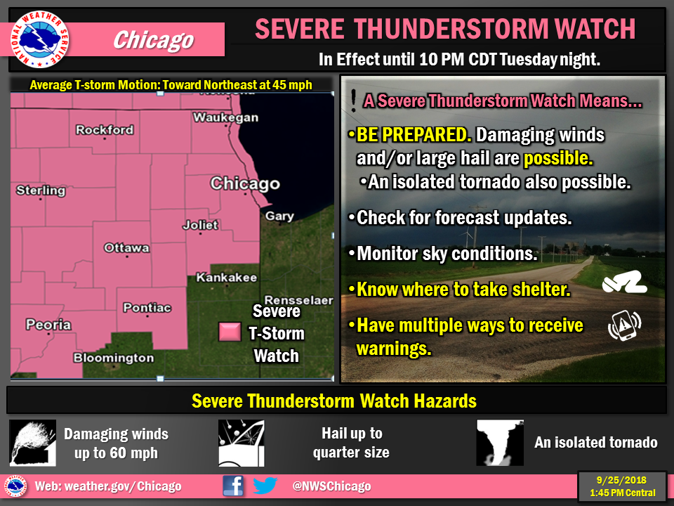 |
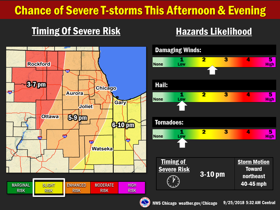
| Issued Sept 24 | Issued Sept 25 6 a.m. | Issued Sept 25 1:45 p.m. |
 |
 |
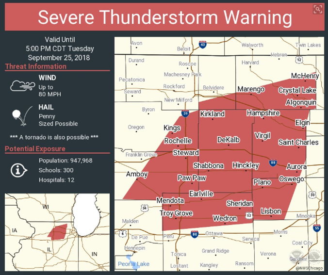 |
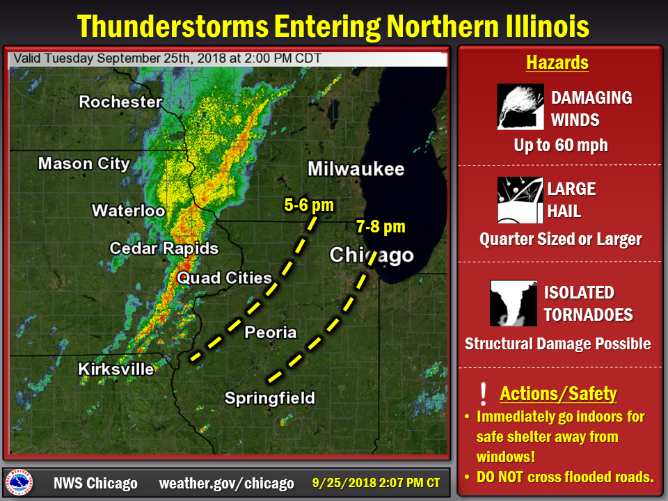
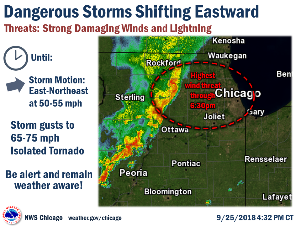
| Issued Sept 25 2 p.m. | Issued Sept 25 4:32 p.m. | One of severe Severe Thunderstorm Warnings, this one issued at Sept 25 4:01 p.m. and included northern Kane and southern McHenry Counties. |
 |
Media use of NWS Web News Stories is encouraged! Please acknowledge the NWS as the source of any news information accessed from this site. Additional recaps can be found on the NWS Chicago Past Events Page |
|

