Record setting heat is expected over the next several days from the Intermountain West through the northern Plains. Furthermore, fire weather concerns increase with dry and breezy conditions. Meanwhile, heavy rainfall and severe thunderstorm threats for the Ohio/Tennessee Valleys, central Appalachians and Southeast today. The threat shifts to central Gulf Coast and across central Texas this week. Read More >
Overview
|
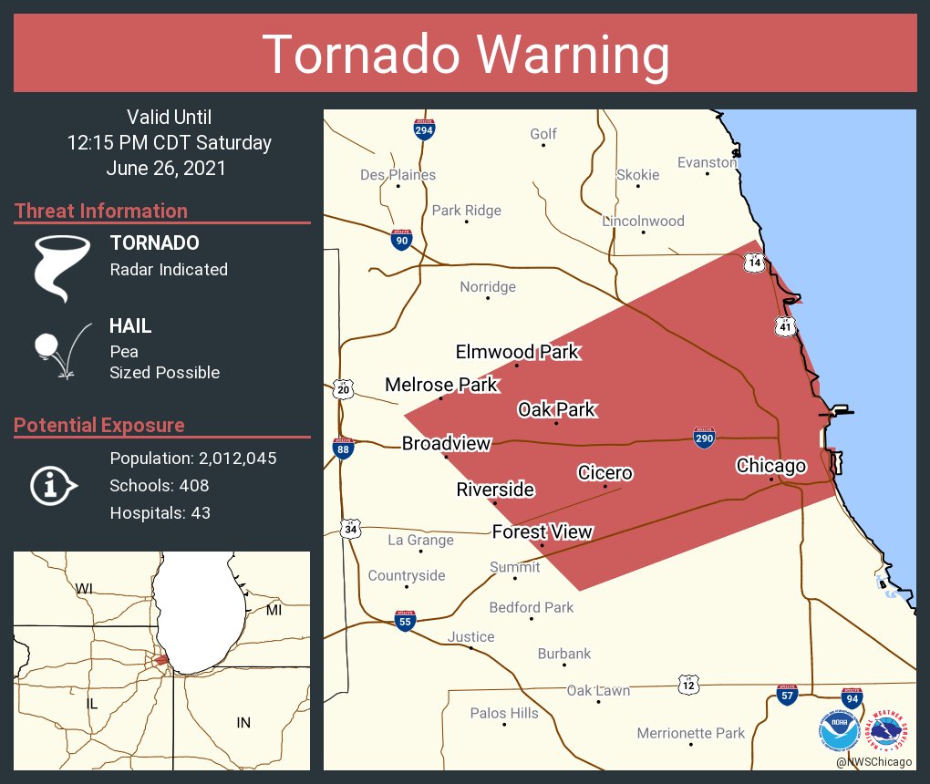
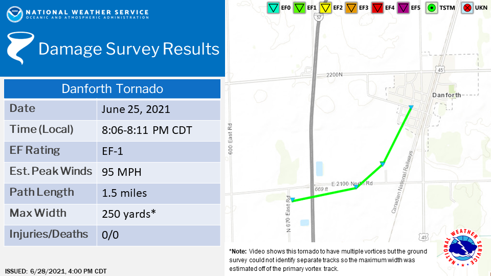
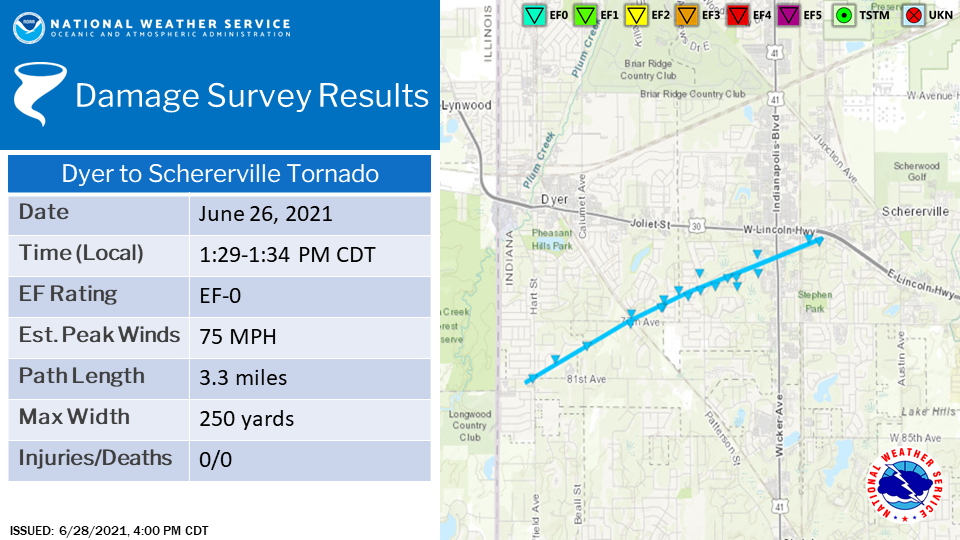
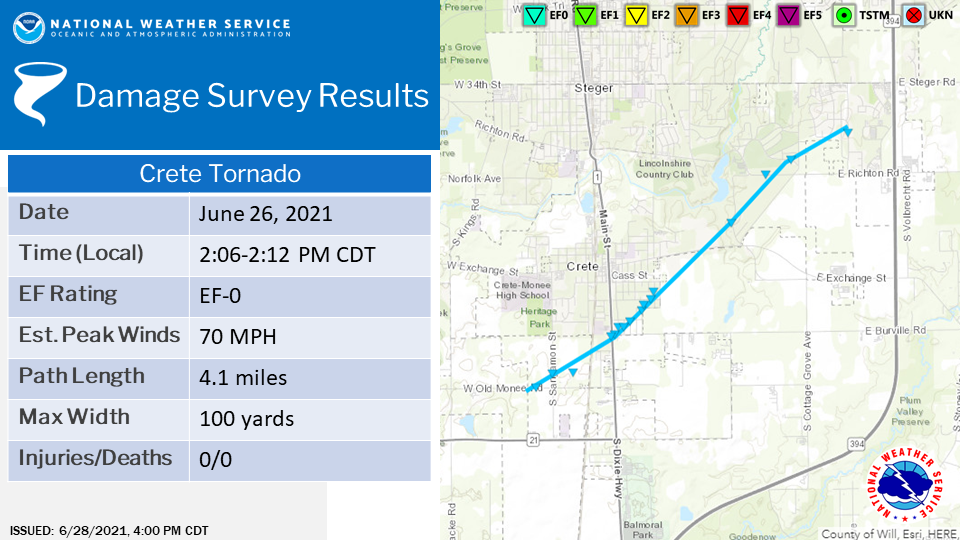
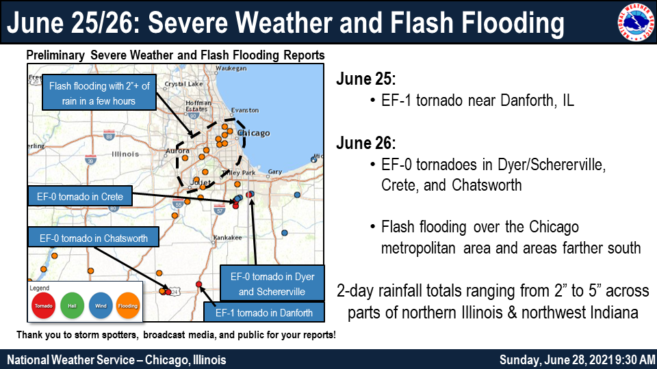
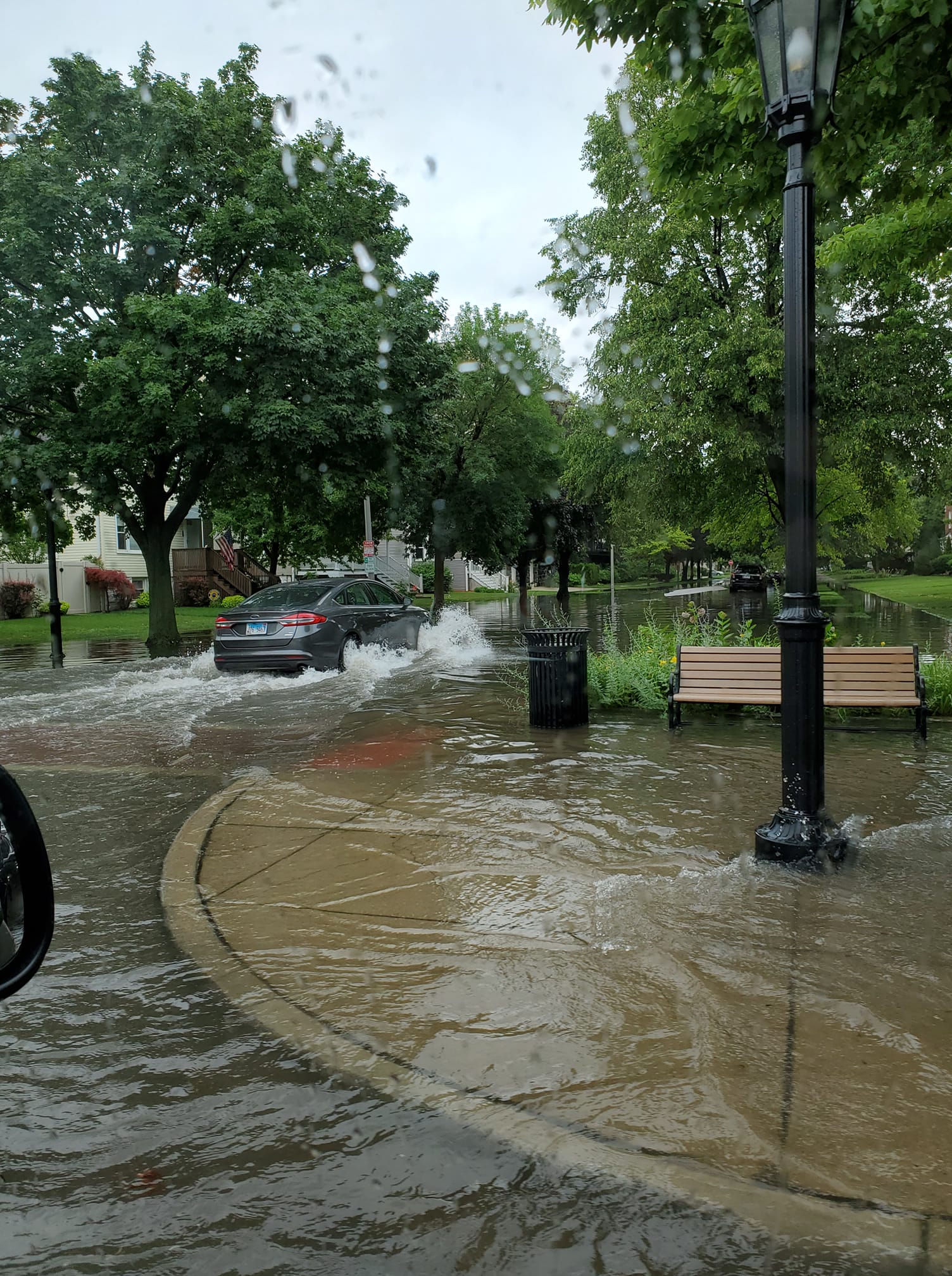
An active late June weather pattern resulted in several consecutive days of heavy rainfall and thunderstorms across northern Illinois and northwest Indiana. On June 25th, these storms produced a brief multi-vortex EF-1 tornado near Danforth, IL, along with heavy rainfall south of the Kankakee River Valley. On June 26th, storms produced three additional EF-0 tornadoes in the area, and heavy rainfall resulted in flash flooding in the Chicago metro and areas farther south. |
 |
Fast Facts:
|
||||||
|
||||||
Tornadoes:
Full Public Information Statement
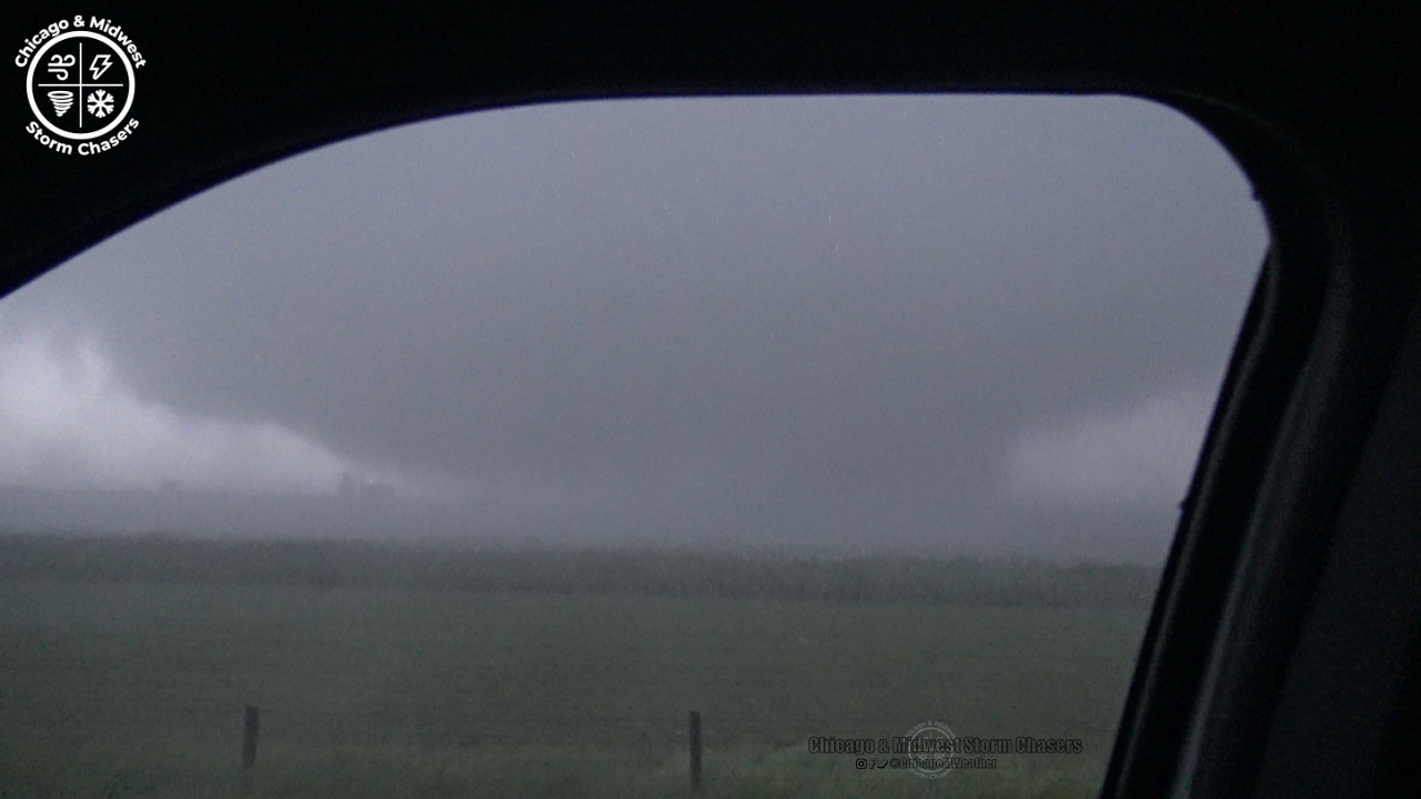
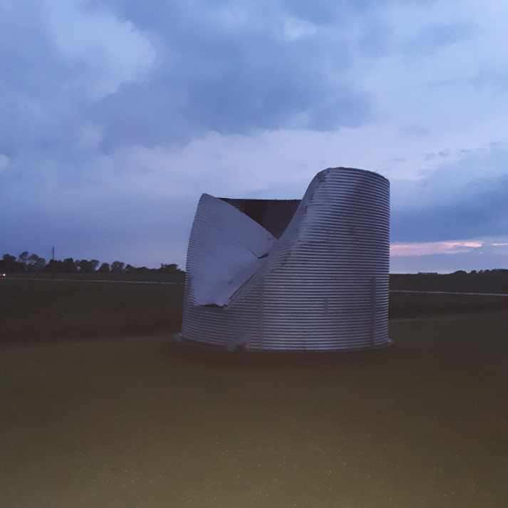
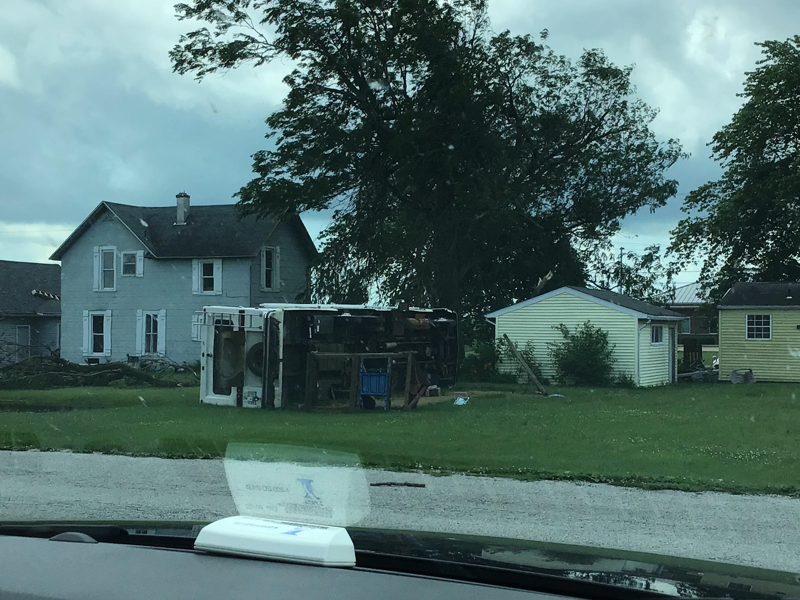
Tornado #1: Danforth EF-1
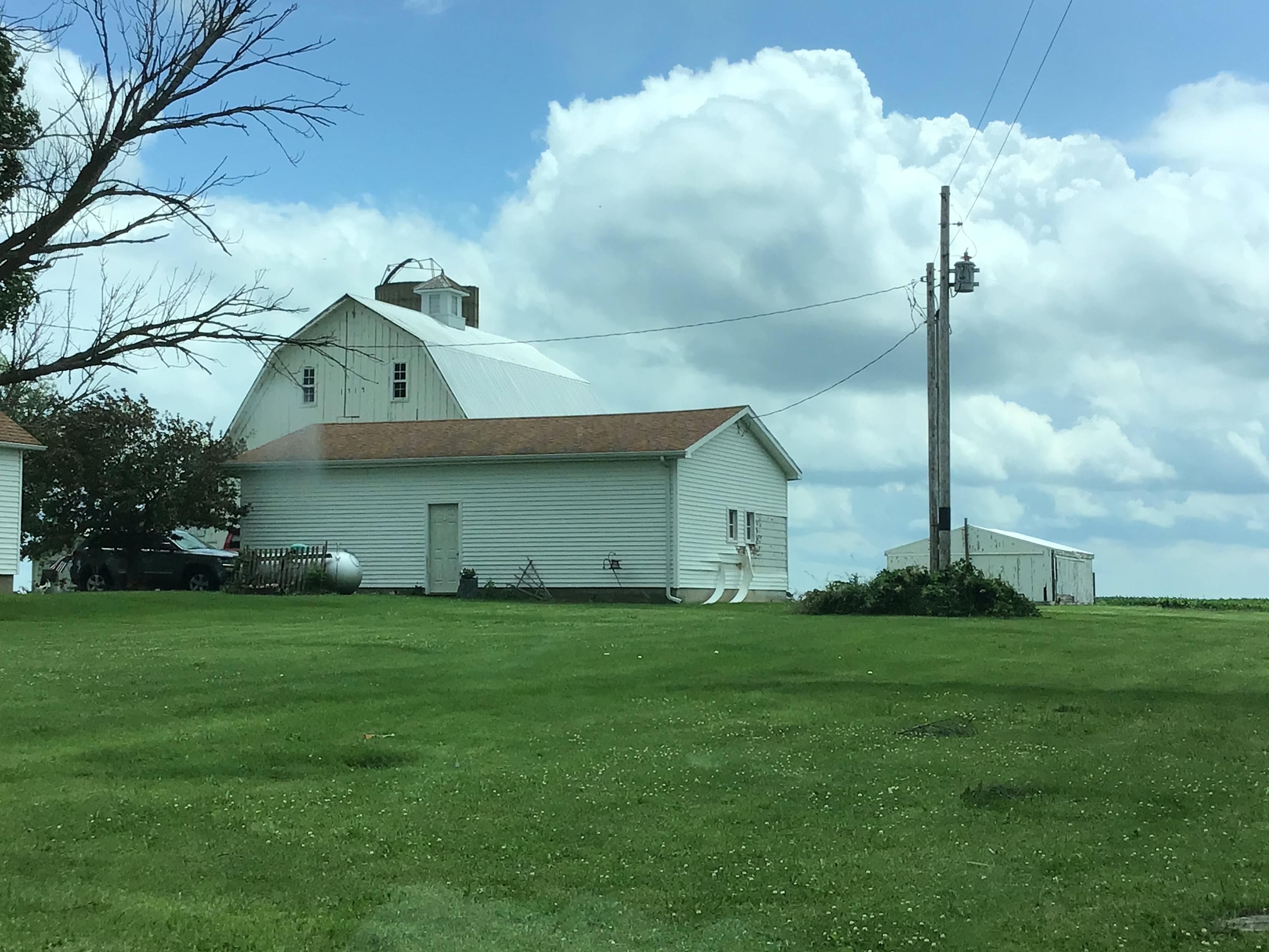
Summary: An NWS storm survey team determined that an EF-1 tornado with peak estimated wind speeds of 95 mph touched down approximately 1 mile southwest of Danforth. The tornado crossed Interstate 57 and caused minor damage to trees, houses, and a grain silo before lifting shortly after it entered the southwest side of Danforth. |
Tornado #2: Dyer-Schererville EF-0
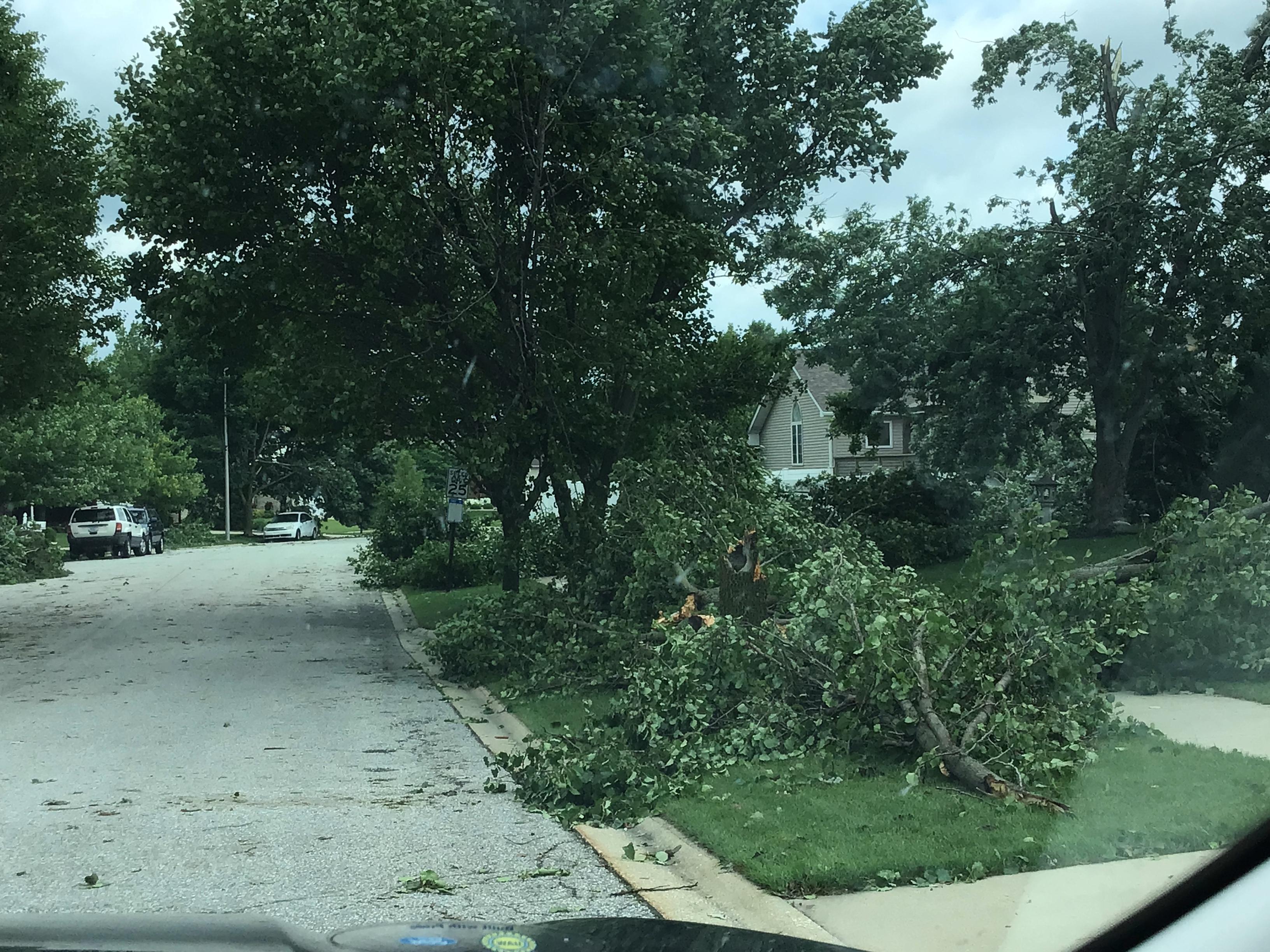
Summary: An NWS storm survey found damage consistent with an EF-0 tornado with estimated peak wind speeds of 75 mph extending from near the Illinois/Indiana state line in Dyer to the west side of Schererville. Primarily tree damage was first noted near the intersection of 81st Ave. and Sheffield Ave. in Dyer. The tornado produced more tree damage as it moved east-northeast through Dyer before it crossed U.S. Route 41 and lifted just south of U.S. Route 30 in Schererville. |
Tornado #3: Crete EF-0
Summary: An NWS storm survey found damage consistent with an EF-0 tornado with estimated peak winds speeds of 70 mph within the village of Crete. Primarily tree damage started near the intersection of Old Monee Rd. and Sangamon St.. The damage extended northeast through Crete, crossing Main St. near Burville Rd. and ending near Ronald Rd. just west of Illinois Route 394. |
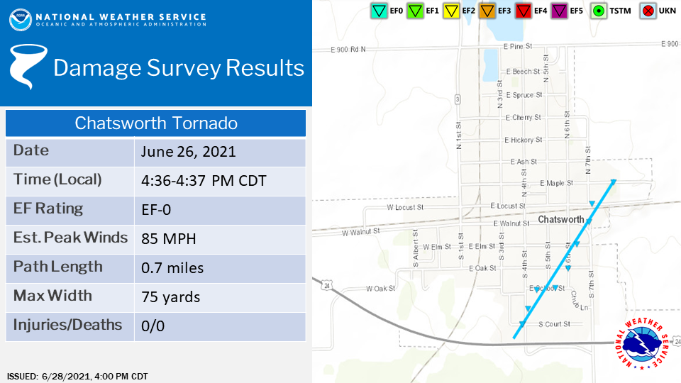
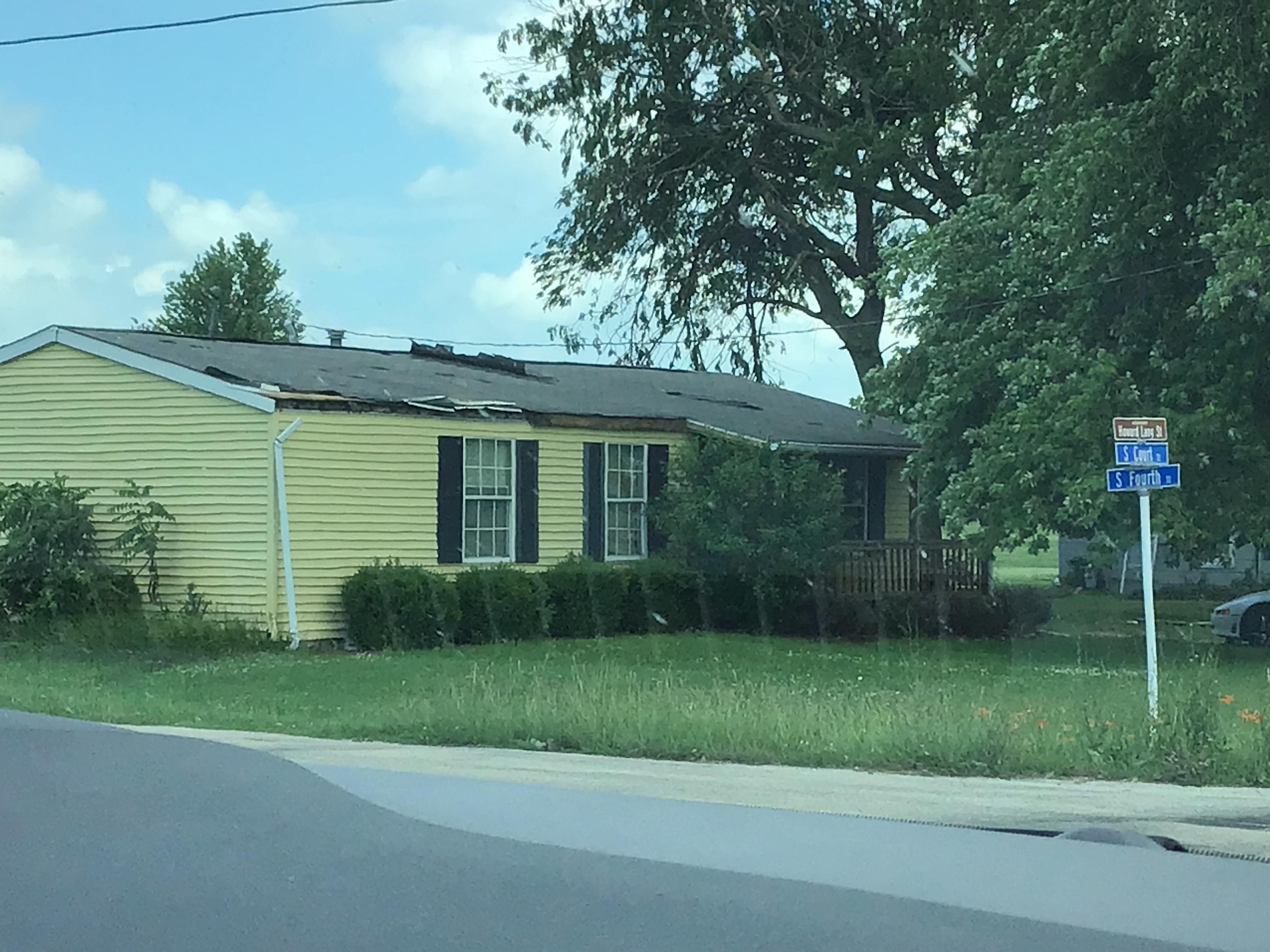
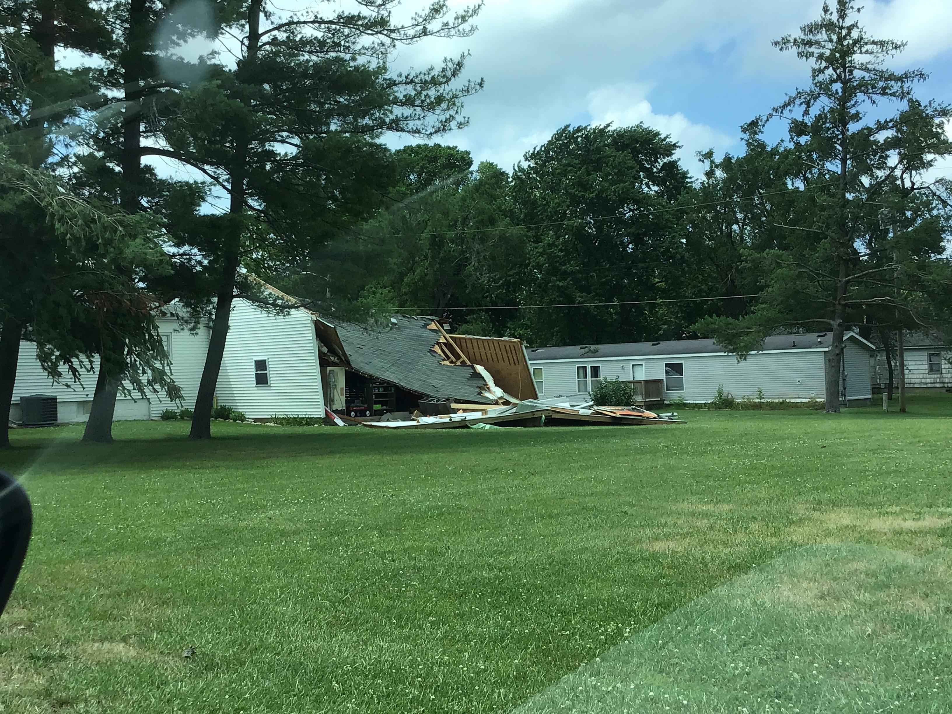
Tornado #4: Chatsworth EF-0
Summary: An NWS storm survey found damage consistent with a brief EF-0 tornado with estimated peak winds speeds of 85 mph on the southeast side of Chatsworth. Damage consisted of a blown out garage door, displaced playground equipment, several downed branches and limbs, and a blown over parked camper. |
The Enhanced Fujita (EF) Scale classifies tornadoes into the following categories:
| EF0 Weak 65-85 mph |
EF1 Moderate 86-110 mph |
EF2 Significant 111-135 mph |
EF3 Severe 136-165 mph |
EF4 Extreme 166-200 mph |
EF5 Catastrophic 200+ mph |
 |
|||||
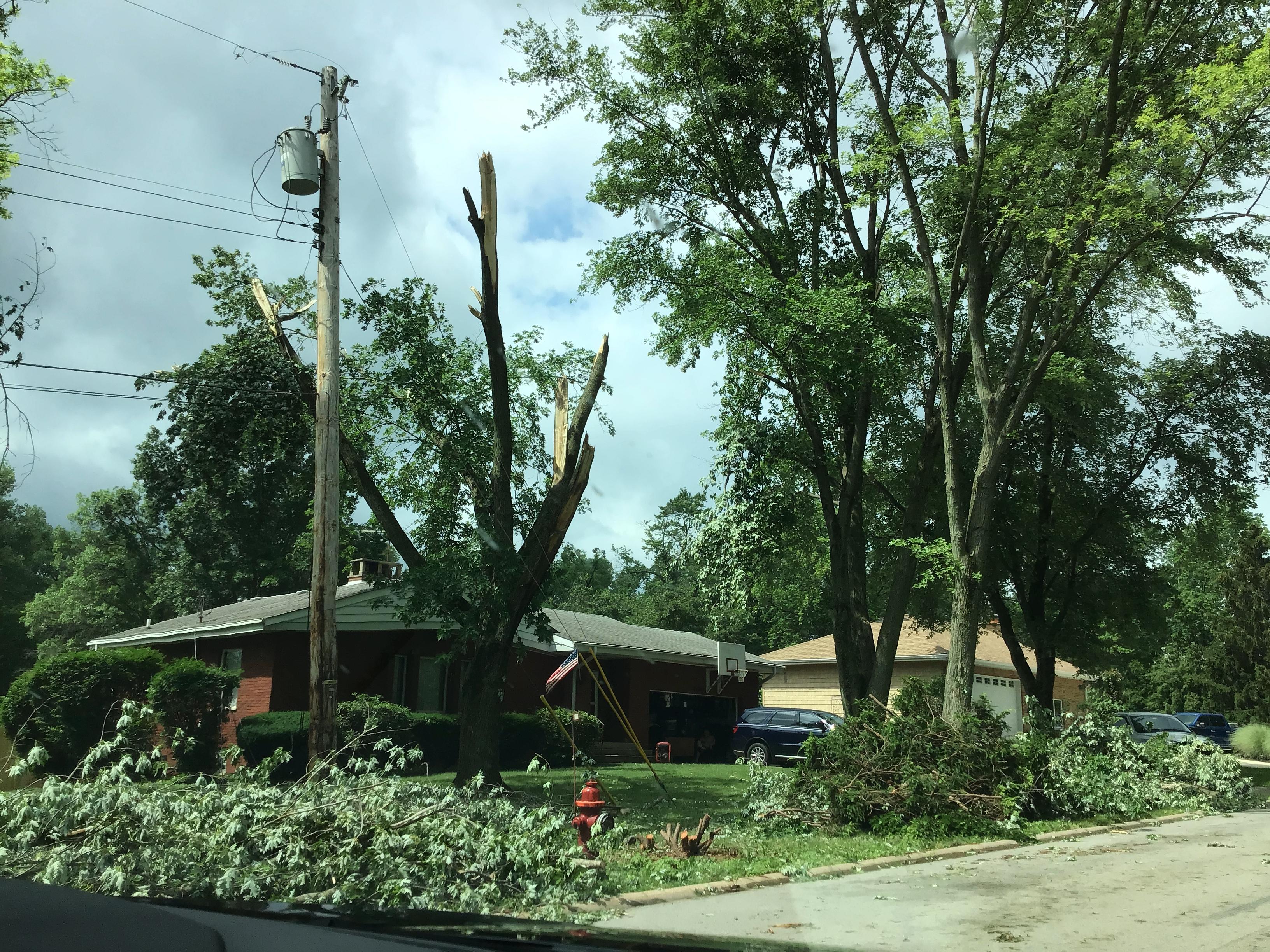
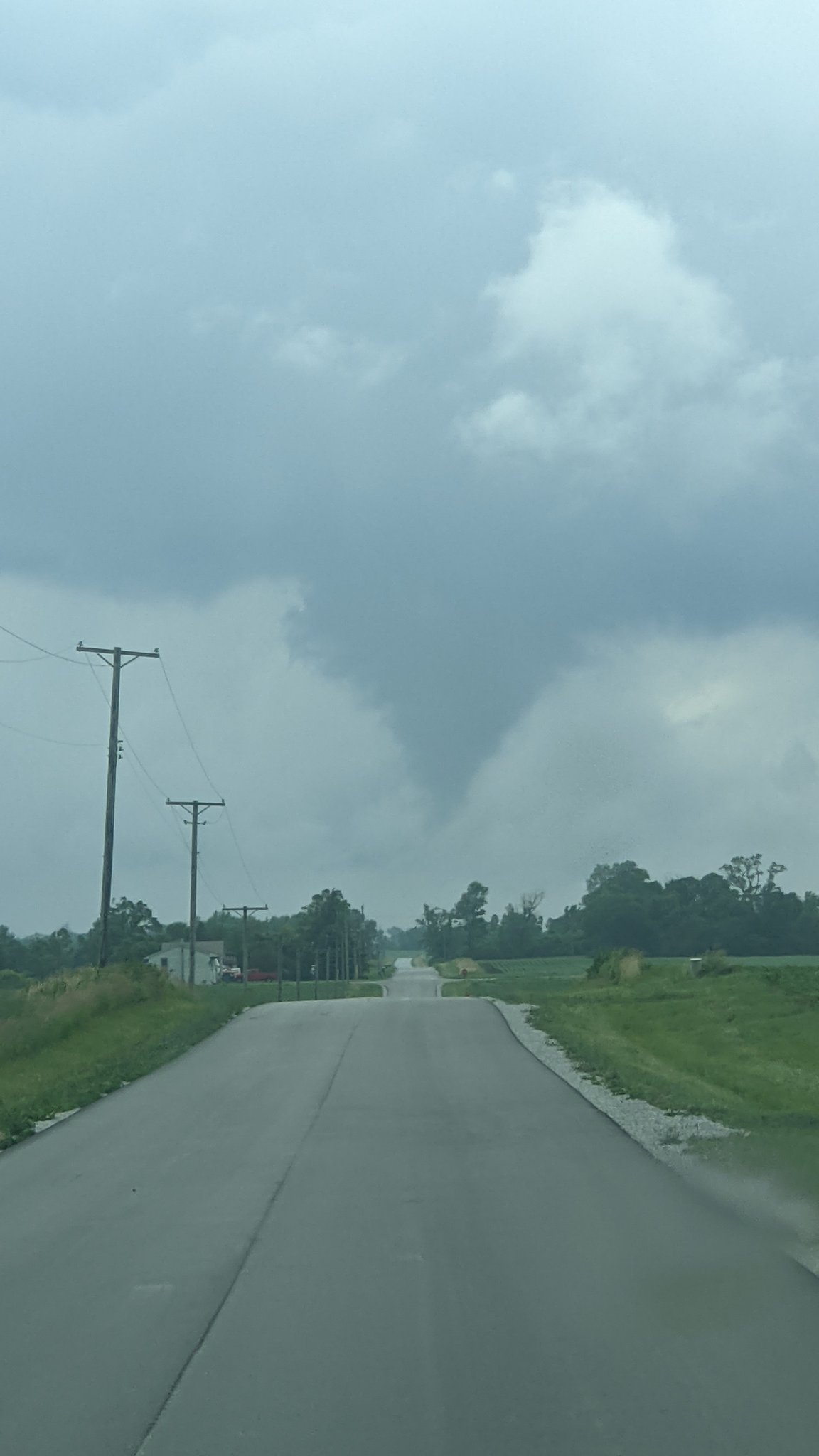
Photos:
Danforth Tornado
 |
 |
 |
| Danforth tornado. Courtesy of Chicago & Midwest Storm Chasers. | Damage near Danforth. Courtesy of Iroquois County EMA. | Damage near Danforth. From NWS storm survey. |
Dyer-Schererville Tornado
 |
 |
 |
| Damage in Dyer. From NWS storm survey. | Damage in Schererville. From NWS storm survey. | Damage in Schererville. From NWS storm survey. |
Crete Tornado
 |
|
|
| Crete tornado. Courtesy of Bob Waszak. | Damage in Crete. From NWS storm survey. | Damage in Crete. From NWS storm survey. |
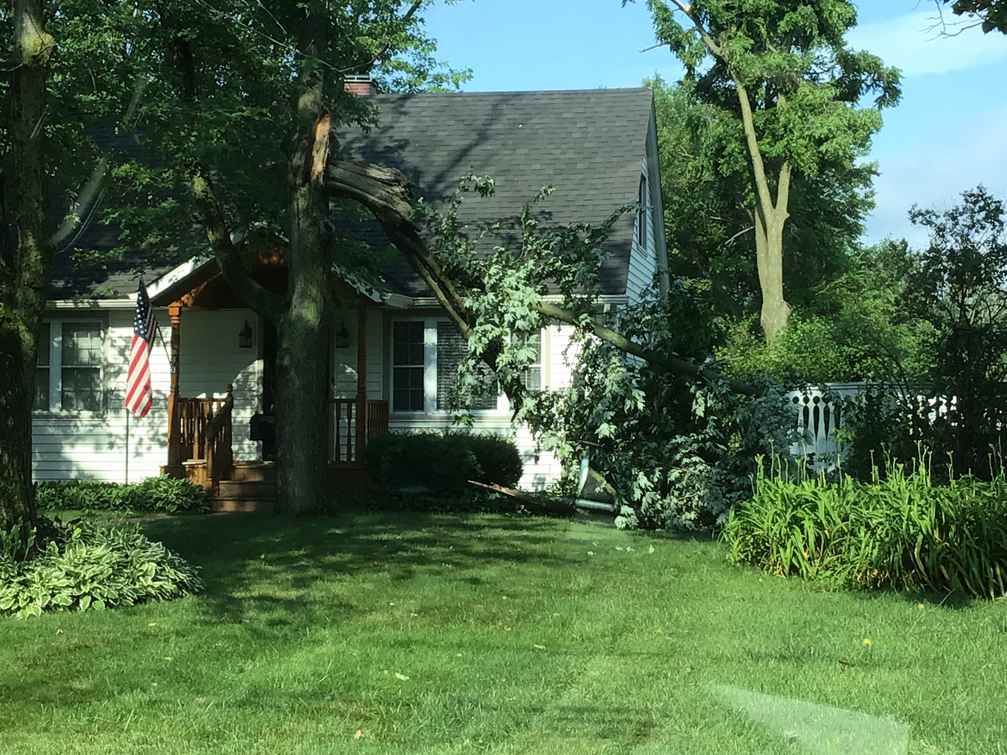
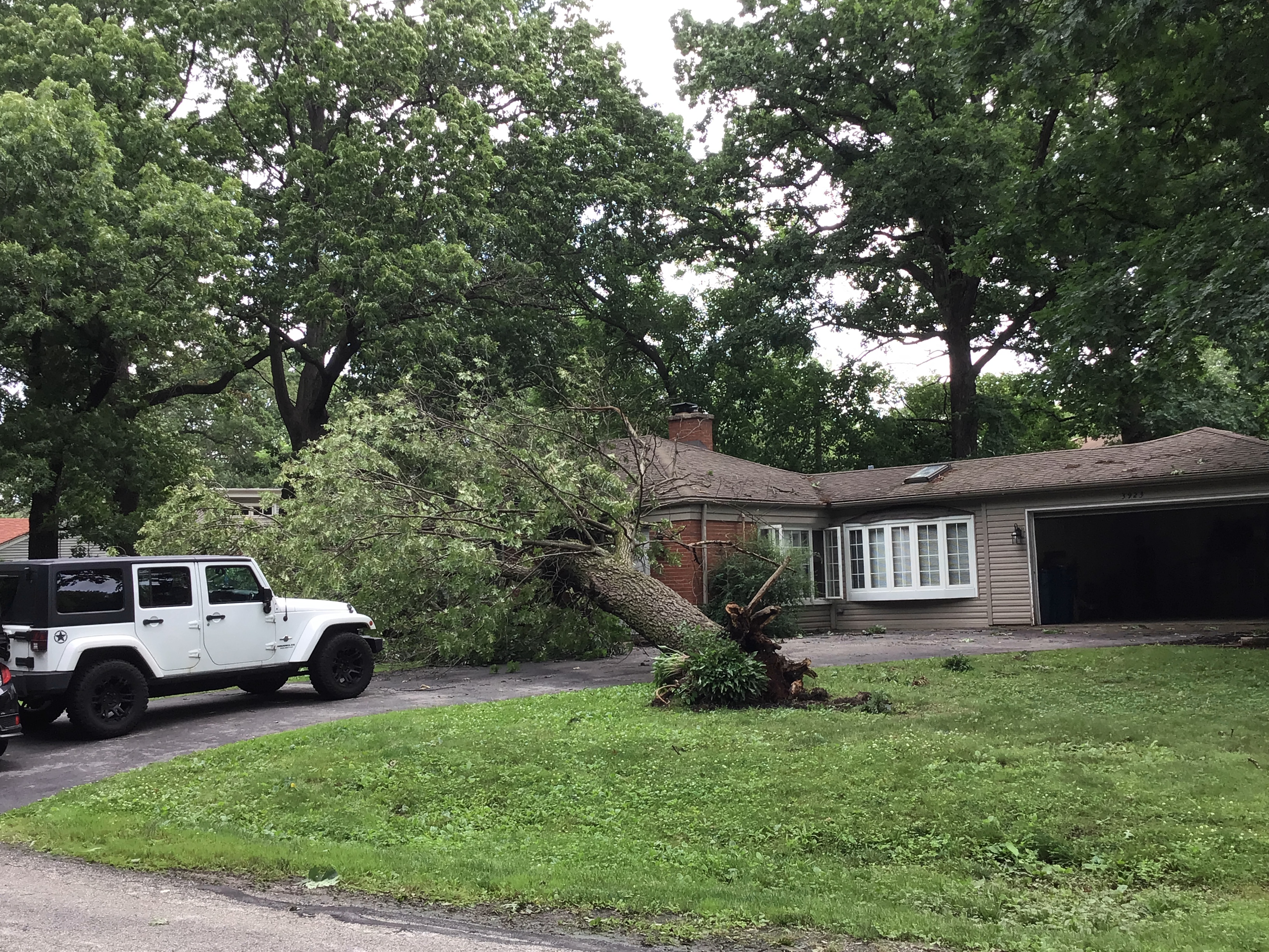
Chatsworth Tornado
 |
 |
 |
| Damage in Chatsworth. From NWS storm survey. | Damage in Chatsworth. From NWS storm survey. | Damage in Chatsworth. From NWS storm survey. |
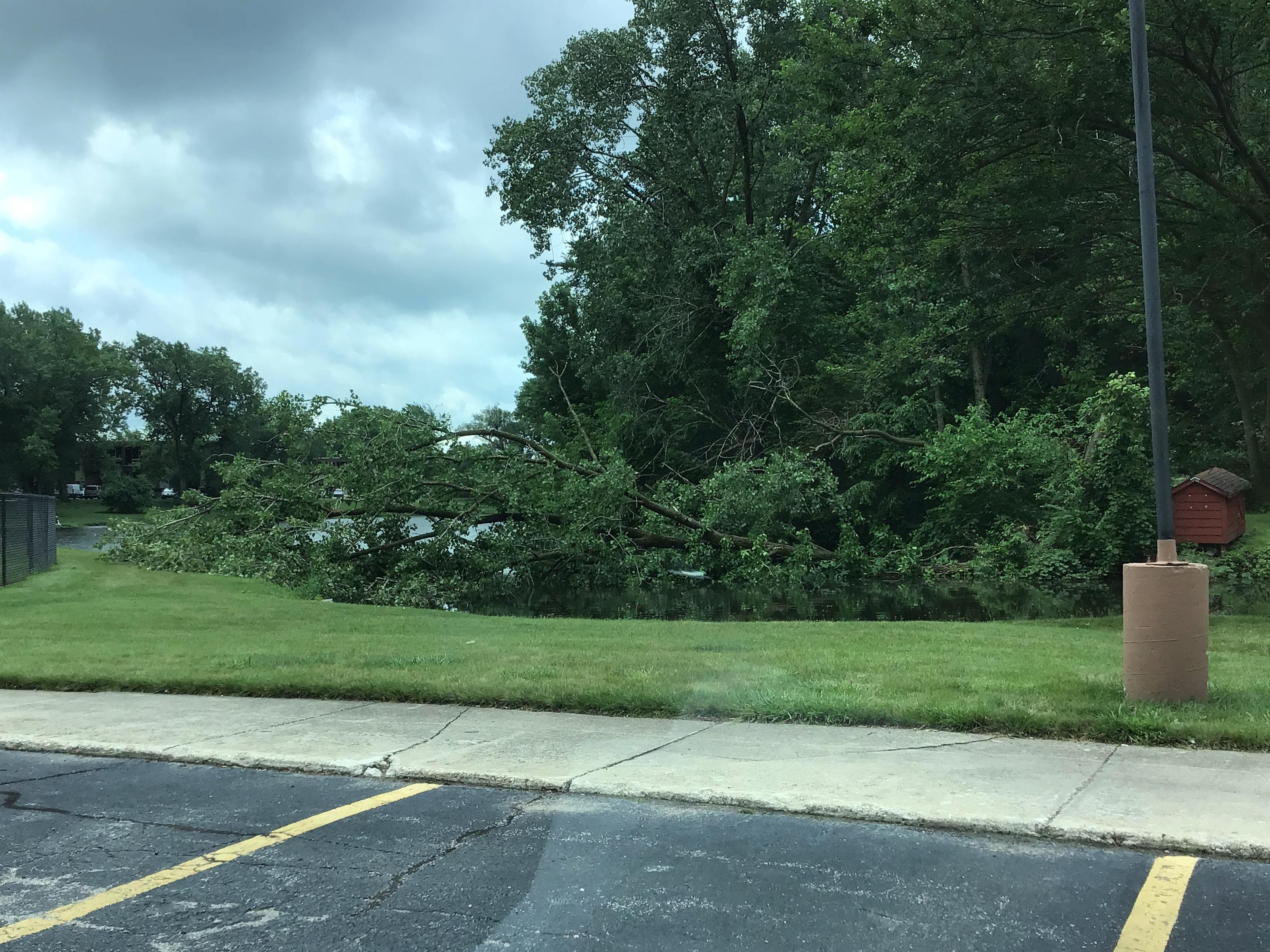
Flooding
|
|
 |
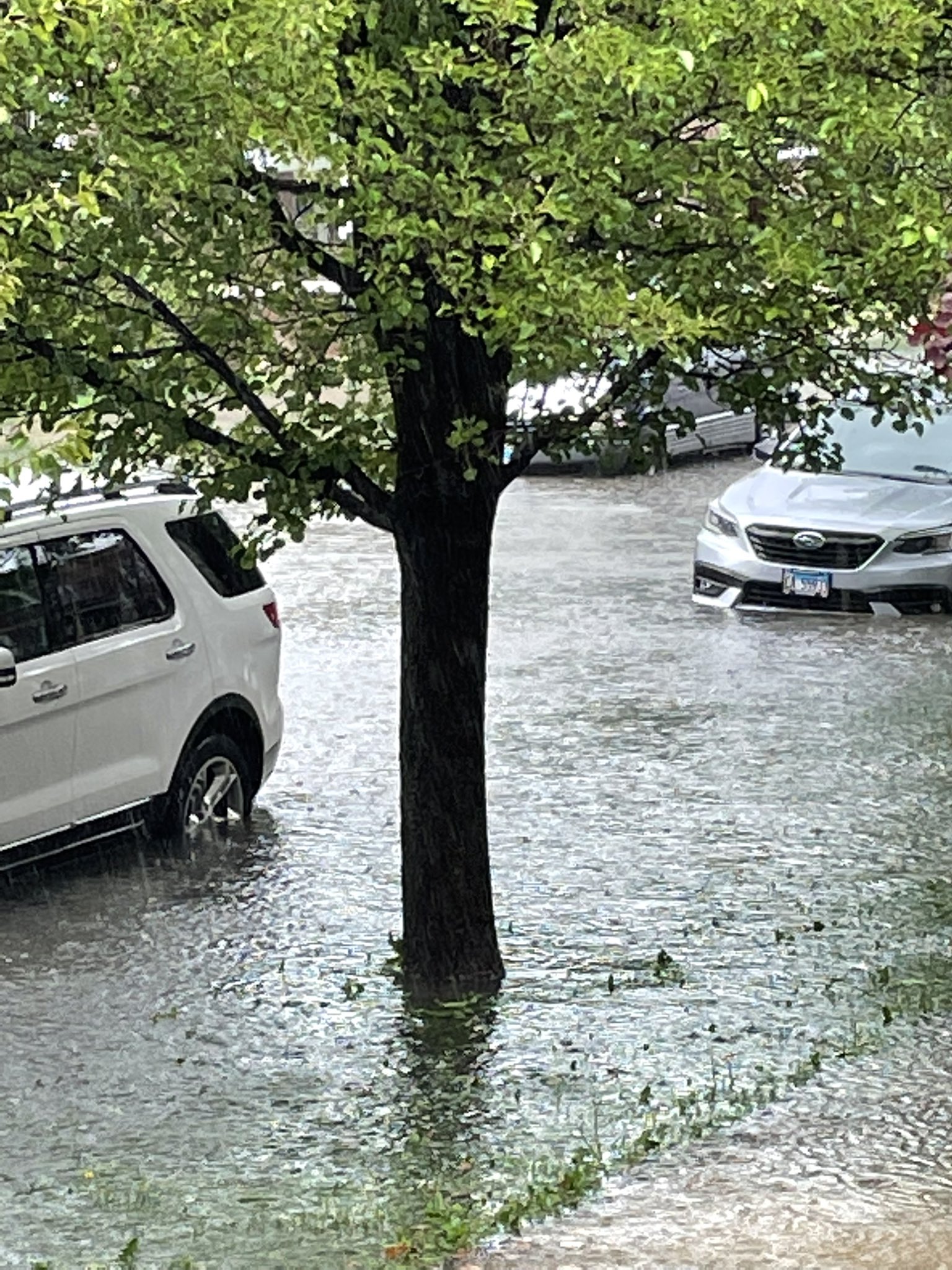 |
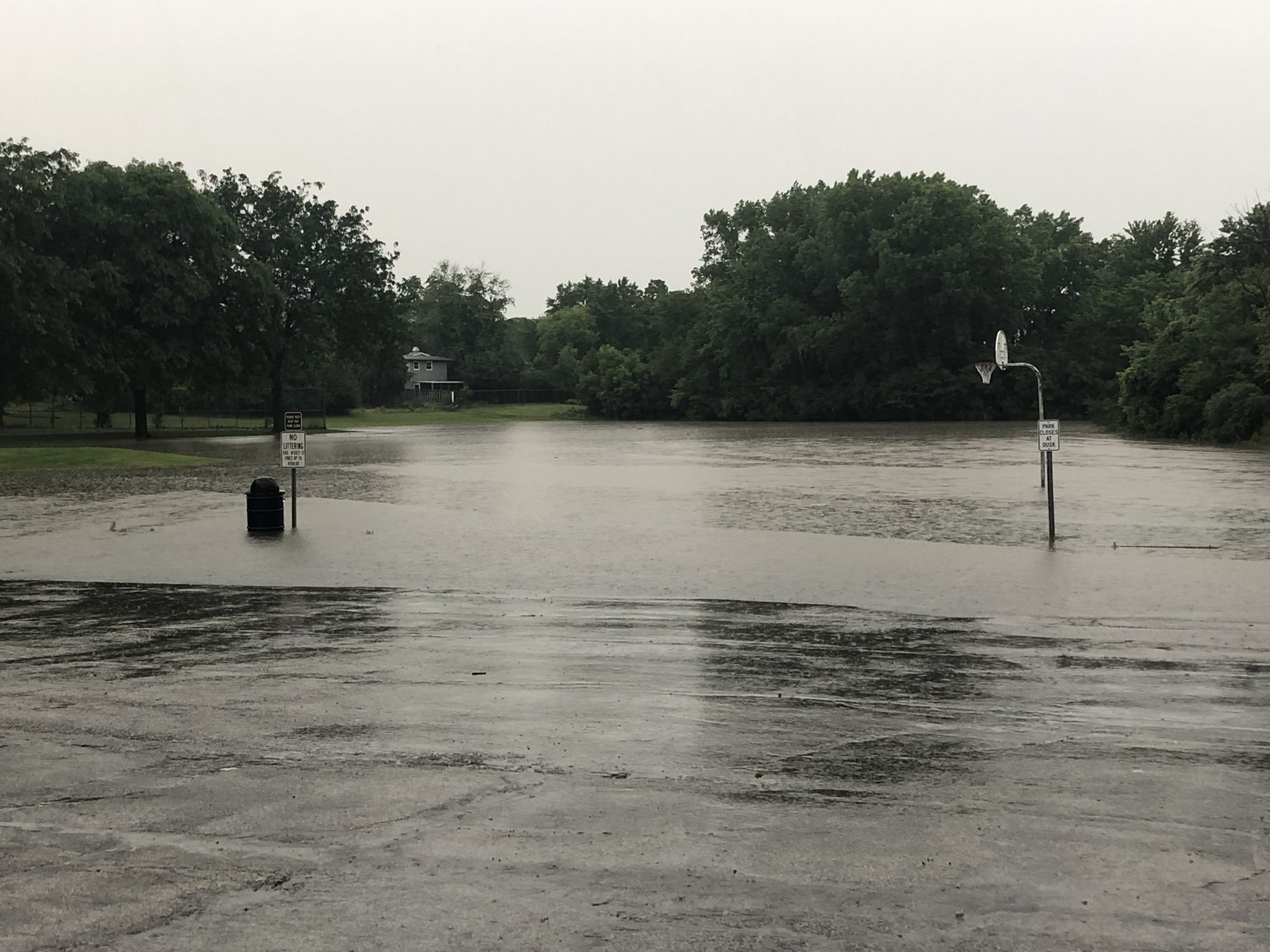
| Flooding in Glenwood. Courtesy of Adam Chappelle. | Flooding in Forest Park. Courtesy of Eric Hogan. | Flooding in Cicero. Courtesy of Scott Ulbrich. |
Other
|
|
|
|
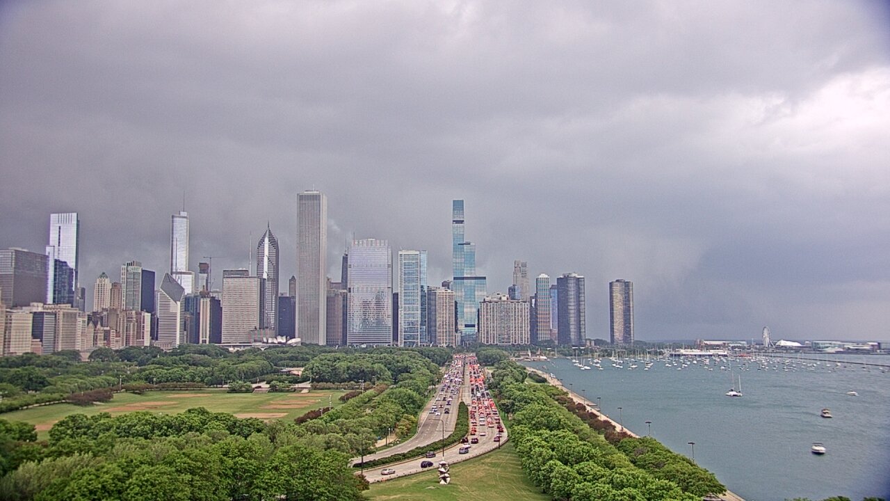
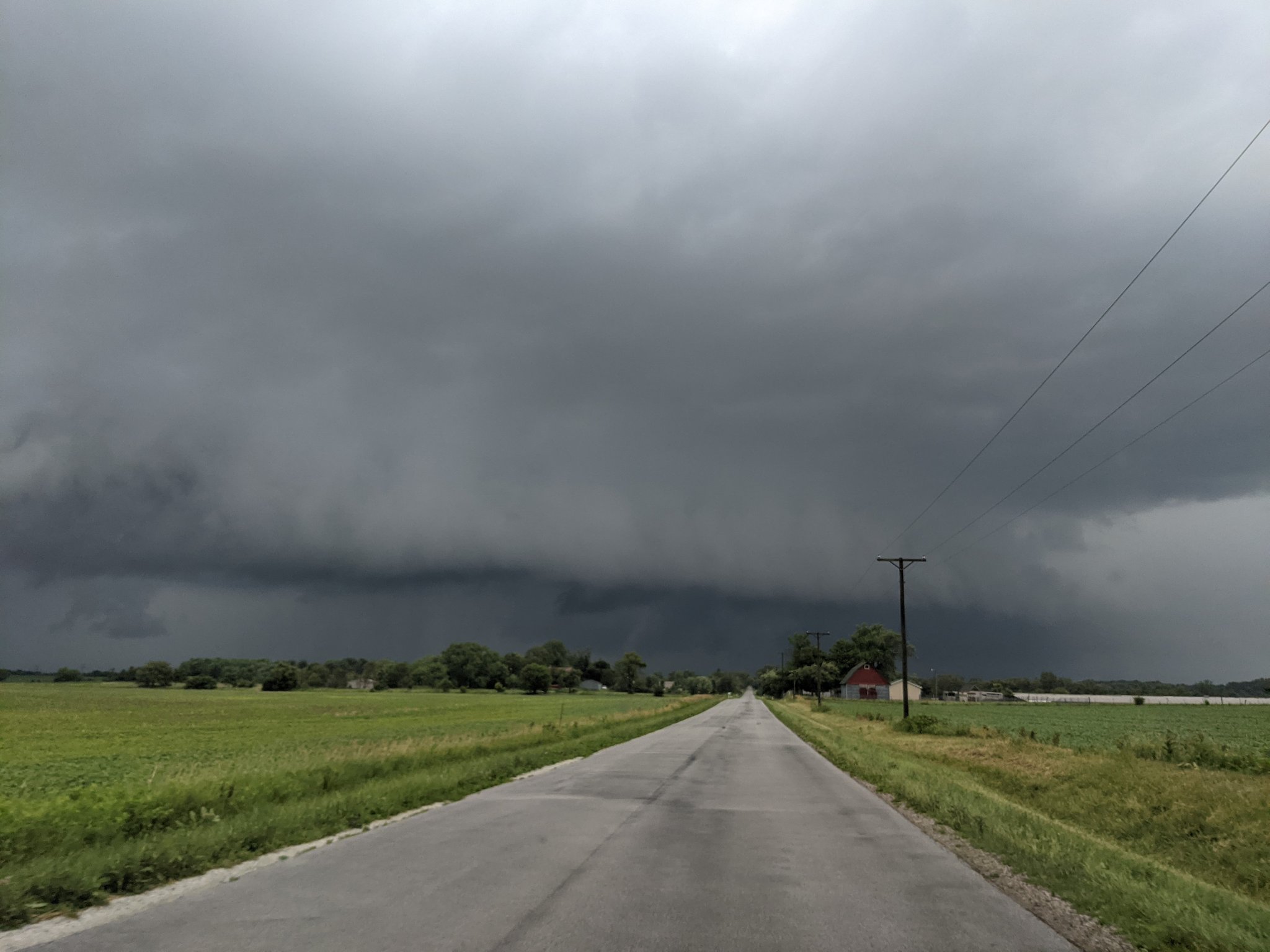
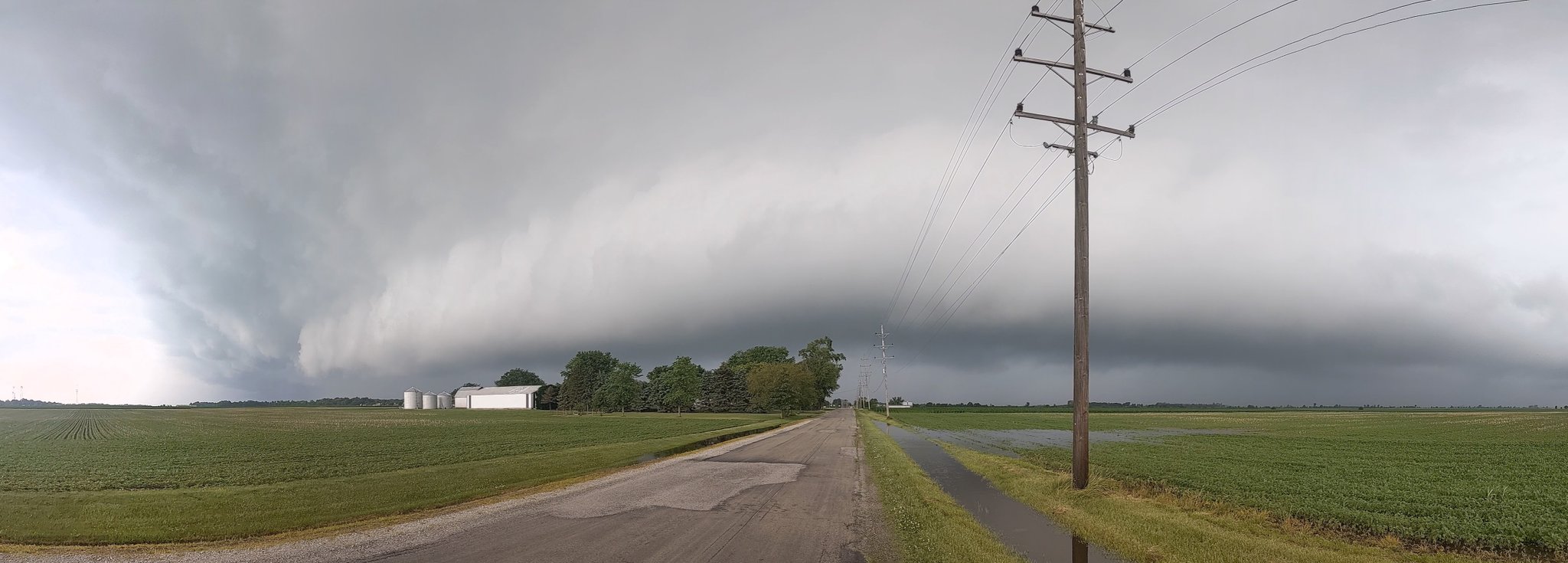
| Tornado warned storm approaching Downtown Chicago | Shelf cloud near Beecher. Courtesy of Nick Stewart. | Shelf cloud near Grant Park. Courtesy of Bob Waszak. |
Storm Reports
PRELIMINARY LOCAL STORM REPORT...SUMMARY
NATIONAL WEATHER SERVICE CHICAGO IL
357 AM CDT SUN JUN 27 2021

..TIME...   ...EVENT...      ...CITY LOCATION...     ...LAT.LON...
..DATE...   ....MAG....      ..COUNTY LOCATION..ST.. ...SOURCE....
            ..REMARKS..

0615 PM     FUNNEL CLOUD     EARL PARK               40.69N 87.41W
06/26/2021                   BENTON             IN   EMERGENCY MNGR

            BRIEF FUNNEL CLOUDS REPORTED VIA EMERGENCY
            MANAGEMENT OVER EARL PARK.

0600 PM     FLASH FLOOD      2 N MANHATTAN           41.45N 87.98W
06/26/2021                   WILL               IL   PUBLIC

            PARTS OF BAKER RD AND NELSON RD FLOODED
            NORTH OF MANHATTAN.

0600 PM     FLASH FLOOD      1 E SAUNEMIN            40.89N 88.38W
06/26/2021                   LIVINGSTON         IL   EMERGENCY MNGR

            ROUTE 116 NEAR SAUNEMIN CLOSED DUE TO
            FLOODING.

0600 PM     FLASH FLOOD      3 W CHATSWORTH          40.76N 88.35W
06/26/2021                   LIVINGSTON         IL   EMERGENCY MNGR

            E 900 RD N BETWEEN FORREST AND CHATSWORTH
            CLOSED DUE TO FLOODING.

0600 PM     FLASH FLOOD      1 WNW GLENWOOD          41.55N 87.63W
06/26/2021                   COOK               IL   PUBLIC

            PHOTOS SHARED ON SOCIAL MEDIA SHOW GEORGE
            ARQUILLA PARK IN GLENWOOD FLOODED.

0559 PM     TSTM WND DMG     VALPARAISO              41.47N 87.06W
06/26/2021                   PORTER             IN   PUBLIC

            PHOTO SHARED ON SOCIAL MEDIA OF LARGE TREE
            LIMB SNAPPED IN VALPARAISO. TIME ESTIMATED
            BY RADAR.

0546 PM     TSTM WND DMG     1 ESE DEMOTTE           41.19N 87.18W
06/26/2021                   JASPER             IN   PUBLIC

            TREE LIMBS DOWNED. TIME ESTIMATED BY RADAR.

0436 PM     TSTM WND DMG     CHATSWORTH              40.75N 88.29W
06/26/2021                   LIVINGSTON         IL   CO-OP OBSERVER

            TREES DOWNED, CAMPER BLOWN OVER, GARAGE
            BUILDING DAMAGED.

0432 PM     FUNNEL CLOUD     1 W GOODENOW            41.39N 87.65W
06/26/2021                   WILL               IL   TRAINED SPOTTER

            NUMEROUS REPORTS OF A ROTATING FUNNEL CLOUD
            NORTH OF BEECHER.

0330 PM     FLASH FLOOD      1 SW HERMOSA - CHICAGO  41.91N 87.75W
06/26/2021                   COOK               IL   PUBLIC

            ROAD UNDERNEATH OVERPASS FLOODED. CAR
            SUBMERGED IN FLOOD WATERS.

0208 PM     TSTM WND DMG     1 ENE CRETE             41.45N 87.61W
06/26/2021                   WILL               IL   EMERGENCY MNGR

            TREE DOWNED ONTO A HOUSE ON MERIONETH DR. IN
            CRETE.

0207 PM     TSTM WND DMG     1 S CRETE               41.44N 87.63W
06/26/2021                   WILL               IL   EMERGENCY MNGR

            TREE AND STRUCTURAL DAMAGE REPORTED ON THE
            SOUTH SIDE OF CRETE.

0207 PM     TSTM WND DMG     CRETE                   41.44N 87.63W
06/26/2021                   WILL               IL   EMERGENCY MNGR

            DEBRIS IN THE ROAD AT EXCHANGE AND LUMBER IN
            CRETE.

0206 PM     FUNNEL CLOUD     2 SE UNIVERSITY PARK    41.42N 87.65W
06/26/2021                   WILL               IL   TRAINED SPOTTER

            SEVERAL SPOTTER REPORTS OF A ROTATING FUNNEL
            CLOUD NEAR CRETE. PHOTO SHARED ON SOCIAL
            MEDIA SHOWS A FUNNEL TWO-THIRDS OF THE WAY
            TO THE GROUND.

0200 PM     FLASH FLOOD      DARIEN                  41.75N 87.97W
06/26/2021                   DUPAGE             IL   PUBLIC

            VIDEO SHARED ON SOCIAL MEDIA SHOWS STREETS,
            SIDEWALKS, AND LAWNS IN DARIEN SUBMERGED
            UNDER A FEW INCHES OF WATER.

0132 PM     TSTM WND DMG     2 SSE DYER              41.48N 87.50W
06/26/2021                   LAKE               IN   TRAINED SPOTTER

            NARROW PATH OF NUMEROUS LARGE LIMBS SNAPPED
            ON THE SOUTHEAST SIDE OF DYER. TIME
            ESTIMATED BY RADAR.

0105 PM     FUNNEL CLOUD     2 W CHATSWORTH          40.75N 88.34W
06/26/2021                   LIVINGSTON         IL   TRAINED SPOTTER

            SPOTTER REPORTED A FUNNEL CLOUD NEAR
            CHATSWORTH.

0100 PM     FLASH FLOOD      2 SSE NAPERVILLE        41.74N 88.13W
06/26/2021                   DUPAGE             IL   COUNTY OFFICIAL

            MULTIPLE ROADS IN NAPERVILLE CLOSED DUE TO
            FLOODING.

0100 PM     FLASH FLOOD      HINSDALE                41.80N 87.93W
06/26/2021                   DUPAGE             IL   BROADCAST MEDIA

            STREETS FLOODED IN HINSDALE.

0100 PM     FLASH FLOOD      2 SSE NAPERVILLE        41.74N 88.13W
06/26/2021                   DUPAGE             IL   COUNTY OFFICIAL

            MULTIPLE ROADWAYS IN NAPERVILLE CLOSED DUE
            TO FLOODING.

0100 PM     FLASH FLOOD      FOREST PARK             41.88N 87.81W
06/26/2021                   COOK               IL   PUBLIC

            STREETS FLOODED IN FOREST PARK.

0100 PM     FLASH FLOOD      1 E AVONDALE - CHICAGO  41.94N 87.70W
06/26/2021                   COOK               IL   PUBLIC

            SOCIAL MEDIA PHOTO SHOWS E BELMONT AVE
            FLOODED WITH SEVERAL INCHES OF WATER.

0100 PM     FLASH FLOOD      CICERO                  41.85N 87.75W
06/26/2021                   COOK               IL   PUBLIC

            SEVERAL STREETS FLOODED IN CICERO.

1253 PM     FLASH FLOOD      1 WSW BERWYN            41.84N 87.80W
06/26/2021                   COOK               IL   PUBLIC

            INTERSECTION OF 29TH ST. AND WISCONSIN AVE.
            COMPLETELY SUBMERGED UNDERWATER. 2.76 INCHES
            OF RAINFALL MEASURED IN 1.5 HOURS.

1250 PM     TSTM WND GST     HARRISON-DEVER CRIB     41.92N 87.58W
06/26/2021  M46 MPH          LMZ741             IL   C-MAN STATION


1200 PM     FLASH FLOOD      1 NNE PORTAGE PARK - CH 41.97N 87.75W
06/26/2021                   COOK               IL   PUBLIC

            SEVERAL MPING REPORTS OF FLOODED YARDS AND
            ROADWAYS ON THE NORTHWEST SIDE OF CHICAGO.
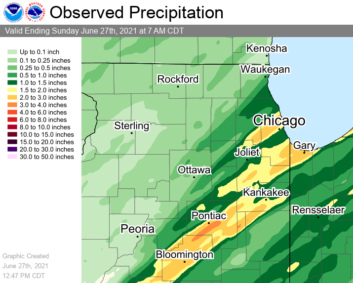
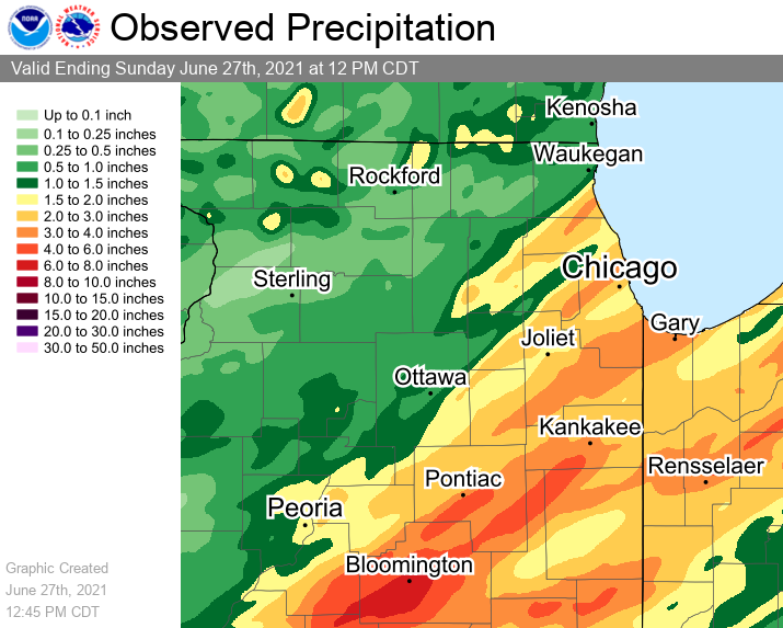
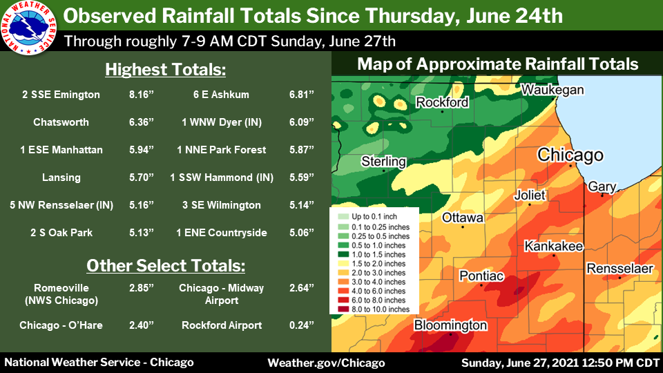
Rain Reports
 |
 |
 |
| Rainfall Totals from Saturday, June 26th | 2-Day Rainfall Totals from Friday, June 25th through Saturday, June 26th | 3-Day Rainfall Totals from Thursday, June 24th through Saturday, June 26th |
Rainfall Totals for Saturday, June 26th:
Public Information Statement...Corrected
National Weather Service Chicago IL
1038 AM CDT Sun Jun 27 2021

...Morning Rainfall Roundup...

   The following are rain amounts for the previous 24-hours
   as measured in the morning by NWS Cooperative Observers
   and CoCoRaHS observers.
   Observations are usually taken between 6 AND 8 AM.

   24-hour rainfall amounts
       for Sunday(06/27/21)...


Illinois                                       Rain
  Location (County):                           fall (inches)

  Naperville 2SE (Du Page).....................3.46
  Countryside 1ENE (Cook)......................3.32
  Oak Park 2S (Cook)...........................3.06
  Park Forest (Cook)...........................2.90
  Oak Park 1NNE (Cook).........................2.56
  Burr Ridge 2SW (Du Page).....................2.51
  Westmont (Du Page)...........................2.37
  La Grange Park 1SSW (Cook)...................2.35
  Ravenswood Manor (Cook)......................2.26
  Manhattan 5ENE (Will)........................2.24
  Manhattan (Will).............................2.21
  Oak Park 1SW (Cook)..........................2.19
  Chicago 6NNE (Cook)..........................2.18
  Emington 2SSE (Livingston)...................2.15
  Manhattan 1ESE (Will)........................2.12
  Lincolnwood 3E (Cook)........................2.09
  Manhattan 2SE (Will).........................2.07
  Darien (Du Page).............................2.00
  Oak Forest 1SSE (Cook).......................1.97
  Naperville 4SSW (Will).......................1.94
  Bolingbrook 3NE (Du Page)....................1.87
  Elmhurst 2SE (Du Page).......................1.83
  Park Forest 1NNE (Cook)......................1.77
  Harwood Heights (Cook).......................1.76
  Coal City 3N (Grundy)........................1.75
  Lincolnwood 2E (Cook)........................1.68
  Oswego 5SSE (Kendall)........................1.66
  Morris 6ESE (Grundy).........................1.61
  Homewood (Cook)..............................1.59
  Chicago 6ESE (Cook)..........................1.58
  Monee (Will).................................1.58
  Peotone (Will)...............................1.55
  Downers Grove 1S (Du Page)...................1.51
  Midlothian 1SE (Cook)........................1.50
  Lincolnshire 1N (Lake).......................1.50
  Brandon Road Lock & Dam (Will)...............1.50
  Chebanse (Kankakee)..........................1.45
  Mokena 1W (Will).............................1.45
  Channahon 2SSE (Will)........................1.45
  New Lenox 2SE (Will).........................1.44
  Coal City 4NNW (Grundy)......................1.41
  Carbon Hill 3.1N (Grundy)....................1.41
  Palatine 1E (Cook)...........................1.40
  Glencoe (Cook)...............................1.33
  New Lenox 3E (Will)..........................1.33
  Plainfield 5SW (Kendall).....................1.32
  Midlothian (Cook)............................1.31
  Elk Grove Village 2WSW (Cook)................1.31
  Lisle (Du Page)..............................1.30
  Oak Lawn (Cook)..............................1.28
  Palos Park 1SW (Cook)........................1.27
  Herscher 3E (Kankakee).......................1.27
  Riverwoods (Lake)............................1.27
  Palatine 1NNE (Cook).........................1.26
  Midway (Cook)................................1.26
  Midway Coop (Cook)...........................1.26
  Hoffman Estates 2SE (Cook)...................1.23
  Wilmington 3SE (Will)........................1.22
  Oak Lawn 2SE (Cook)..........................1.21
  Lansing (Cook)...............................1.19
  Winnetka 1ESE (Cook).........................1.17
  Plano (Kendall)..............................1.14
  Crete 3E (Will)..............................1.12
  Chicago Ridge (Cook).........................1.11
  New Lenox 3ENE (Will)........................1.10
  Wilmington 6NW (Will)........................1.10
  Oak Lawn 2WNW (Cook).........................1.09
  Dwight (Livingston)..........................1.02
  Schaumburg 2E (Cook).........................1.02
  Bridgeview 1NNW (Cook).......................1.01
  Crete 3SSW (Will)............................1.01
  Highwood 1S (Lake)...........................1.00
  Elk Grove Village 1ESE (Cook)................0.97
  Libertyville 2ESE (Lake).....................0.97
  Cissna Park 1S (Iroquois)....................0.96
  Plainfield 3ESE (Will).......................0.95
  Lockport 1SE (Will)..........................0.92
  Batavia (Kane)...............................0.91
  Bourbonnais (Kankakee).......................0.89
  Wheeling (Cook)..............................0.85
  Elmhurst (Du Page)...........................0.84
  St. Charles (Kane)...........................0.84
  Geneva 4WSW (Kane)...........................0.82
  Arlington Heights 1S (Cook)..................0.81
  Arlington Heights 1SW (Cook).................0.80
  Pontiac (Livingston).........................0.77
  Lake Zurich (Lake)...........................0.76
  Channahon 1NNE (Will)........................0.71
  Paxton (Ford)................................0.70
  Joliet 3WNW (Will)...........................0.69
  Schaumburg (Du Page).........................0.68
  Earlville 3S (La Salle)......................0.66
  Gibson 6NE (Ford)............................0.65
  St Anne (Kankakee)...........................0.64
  West Chicago (Du Page).......................0.63
  Hoffman Estates 5W (Cook)....................0.61
  Morris 2SSE (Grundy).........................0.60
  Batavia 2WNW (Kane)..........................0.59
  Romeoville (Will)............................0.59
  Barrington (Lake)............................0.58
  Park Ridge (Cook)............................0.58
  Villa Park 1NW (Du Page).....................0.58
  Aurora (Kane)................................0.55
  Sugar Grove 1ENE (Kane)......................0.54
  Gibson 3WNW (Ford)...........................0.51
  Willow Springs (Cook)........................0.50
  Elgin (Kane).................................0.48
  Aurora 4NE (Du Page).........................0.48
  Elgin 1S (Kane)..............................0.48
  Sugar Grove 1NE (Kane).......................0.47
  North Utica 6N (La Salle)....................0.46
  O`Hare Airport (Cook)........................0.46

Indiana                                        Rain
  Location (County):                           fall (inches)

  Dyer 1WNW (Lake).............................2.63
  Gary 5ENE (Lake).............................2.24
  Rensselaer 5NW (Jasper)......................1.92
  Remington (Jasper)...........................1.88
  Hammond 1SSW (Lake)..........................1.57
  Rensselaer (Jasper)..........................1.57
  Rensselaer 4N (Jasper).......................1.53
  Rensselaer 10NNE (Jasper)....................1.45
  Kentland (Newton)............................1.37
  Mount Ayr 2NNE (Newton)......................1.35
  Rensselaer 6SE (Jasper)......................1.34
  Rensselaer 2SSW (Jasper).....................1.30
  Hebron 4NE (Porter)..........................1.28
  Hebron 1NW (Porter)..........................1.28
  Schererville 1E (Lake).......................1.26
  Valparaiso 6SSW (Porter).....................1.11
  Lakes Of The Four Seasons (Porter)...........1.10
  Valparaiso 1NNW (Porter).....................1.04
  Valparaiso 1SE (Porter)......................1.01
  Schererville 1E (Lake).......................1.00
  Chesterton 1ENE (Porter).....................0.87
  Valparaiso 2WNW (Porter).....................0.85
  Valparaiso (Porter)..........................0.83
  Valparaiso 4SW (Porter)......................0.82
  De Motte 1NNW (Jasper).......................0.80
  Portage 3E (Porter)..........................0.75
  Porter 1S (Porter)...........................0.74
  De Motte 1SSW (Jasper).......................0.70
  Wheatfield 3S (Jasper).......................0.66
  Valparaiso 2N (Porter).......................0.62
  Morocco (Newton).............................0.60
  De Motte 6S (Jasper).........................0.48
  De Motte 4SW (Jasper)........................0.46
  De Motte 1SW (Jasper)........................0.38
  Wheatfield 4WSW (Jasper).....................0.28
2-Day Rainfall Totals for Friday, June 25th and Saturday, June 26th:
Public Information Statement
National Weather Service Chicago/Romeoville IL
1120 AM CDT Sun Jun 27 2021


...2-Day Rainfall Round-up...

The following are rainfall amounts for the previous 2 days
as measured in the morning by NWS Cooperative observers
and CoCoRaHS observers. Observations are usually taken between
6 AM and 8 AM.

  2-day rain totals for Sunday (06/27/21)
     as of 10:40 AM CDT

ILLINOIS                                 2-Day rainfall
  Location (County):                         Amt(inches) reports

  Ashkum 5.6E (Iroquois).......................5.73     (2)
  Manhattan 5ENE (Will)........................4.45     (2)
  Naperville 2SE (Du Page).....................4.42     (2)
  Manhattan (Will).............................4.31     (2)
  Manhattan 1ESE (Will)........................4.27     (2)
  Chatsworth (Livingston)......................4.25     (2)
  Oak Park 2S (Cook)...........................3.97     (2)
  Park Forest 1NNE (Cook)......................3.91     (2)
  Manhattan 2SE (Will).........................3.83     (2)
  Park Forest (Cook)...........................3.80     (2)
  Countryside 1ENE (Cook)......................3.74     (2)
  Herscher 3E (Kankakee).......................3.69     (2)
  Burr Ridge 2SW (Du Page).....................3.64     (2)
  Emington 2SSE (Livingston)...................3.60     (2)
  Mokena 1W (Will).............................3.57     (2)
  Oak Forest 1SSE (Cook).......................3.48     (2)
  Chebanse (Kankakee)..........................3.43     (2)
  Oak Park 1NNE (Cook).........................3.36     (2)
  La Grange Park 1SSW (Cook)...................3.26     (2)
  Paxton (Ford)................................3.20     (2)
  Arlington Heights 1SW (Cook).................3.19     (2)
  Westmont (Du Page)...........................3.18     (2)
  New Lenox 2SE (Will).........................3.16     (2)
  Midlothian (Cook)............................3.16     (2)
  Riverwoods (Lake)............................3.13     (2)
  New Lenox 3E (Will)..........................3.11     (2)
  Palatine 1E (Cook)...........................3.04     (2)
  St Anne (Kankakee)...........................3.03     (2)
  Homewood (Cook)..............................2.99     (2)
  Arlington Heights 1S (Cook)..................2.99     (2)
  Plainfield 5SW (Kendall).....................2.98     (2)
  Darien (Du Page).............................2.94     (2)
  Lincolnshire 1N (Lake).......................2.93     (2)
  New Lenox 3ENE (Will)........................2.88     (2)
  Oak Lawn (Cook)..............................2.84     (2)
  Peotone (Will)...............................2.83     (2)
  Wilmington 3SE (Will)........................2.83     (2)
  Peotone (Will)...............................2.83     (2)
  Coal City 3N (Grundy)........................2.82     (2)
  Morris 6ESE (Grundy).........................2.71     (2)
  Gibson 3WNW (Ford)...........................2.71     (2)
  Bolingbrook 3NE (Du Page)....................2.68     (2)
  Wheeling (Cook)..............................2.66     (2)
  Lincolnwood 2E (Cook)........................2.64     (2)
  Gibson 2SW (Ford)............................2.60     (2)
  Hoffman Estates 2SE (Cook)...................2.60     (2)
  Monee (Will).................................2.59     (2)
  Naperville 4SSW (Will).......................2.56     (2)
  Elk Grove Village 2WSW (Cook)................2.56     (2)
  Palatine 1NNE (Cook).........................2.56     (2)
  Highwood 1S (Lake)...........................2.52     (2)
  Harwood Heights (Cook).......................2.51     (2)
  Ravenswood Manor (Cook)......................2.51     (2)
  Cropsey 1NE (Livingston).....................2.48     (1)
  Elmhurst 2SE (Du Page).......................2.48     (2)
  Lincolnwood 3E (Cook)........................2.47     (2)
  Cissna Park 1S (Iroquois)....................2.43     (2)
  Carbon Hill 3.1N (Grundy)....................2.42     (2)
  Coal City 4NNW (Grundy)......................2.42     (2)
  Channahon 2SSE (Will)........................2.39     (2)
  Bourbonnais (Kankakee).......................2.36     (2)
  Brandon Road Lock & Dam (Will)...............2.30     (2)
  Batavia (Kane)...............................2.30     (2)
  Lisle (Du Page)..............................2.29     (2)
  Dwight (Livingston)..........................2.27     (2)
  Palos Park 1SW (Cook)........................2.25     (2)
  Joliet 3WNW (Will)...........................2.20     (2)
  Chicago 6NNE (Cook)..........................2.18     (1)
  Gibson 6NE (Ford)............................2.16     (2)
  Chicago 6ESE (Cook)..........................2.15     (2)
  Lockport 1SE (Will)..........................2.14     (2)
  Crete 3E (Will)..............................2.13     (2)
  Glencoe (Cook)...............................2.13     (2)
  Lansing (Cook)...............................2.13     (2)
  Oak Lawn 2SE (Cook)..........................2.10     (2)
  Chicago Ridge (Cook).........................2.07     (2)
  Geneva 4WSW (Kane)...........................2.06     (2)
  Downers Grove 1S (Du Page)...................2.03     (2)
  Romeoville (Will)............................2.01     (2)
  Channahon 1NNE (Will)........................2.01     (2)
  Winnetka 1ESE (Cook).........................1.98     (2)
  Morris 5NNW (Grundy).........................1.95     (2)
  Elburn (Kane)................................1.89     (2)
  Beecher 3SSE (Will)..........................1.88     (1)
  St. Charles (Kane)...........................1.88     (2)
  Barrington (Lake)............................1.88     (2)
  Plano (Kendall)..............................1.87     (2)
  Wilmington 6NW (Will)........................1.85     (2)
  Hoffman Estates 5W (Cook)....................1.85     (2)
  Midway (Cook)................................1.83     (2)
  Plainfield 3ESE (Will).......................1.82     (2)
  Watseka 6.9WNW (Iroquois)....................1.79     (2)
  Midway Coop (Cook)...........................1.78     (2)
  Batavia 2WNW (Kane)..........................1.77     (2)
  Streator 1WSW (La Salle).....................1.76     (1)
  Elk Grove Village 1ESE (Cook)................1.76     (2)
  Schaumburg (Du Page).........................1.74     (2)
  Elgin (Kane).................................1.72     (2)
  West Chicago (Du Page).......................1.71     (2)
  Bridgeview 1NNW (Cook).......................1.69     (2)
  Oak Lawn 2WNW (Cook).........................1.68     (2)
  Joliet 2n (Will).............................1.67     (2)
  Oswego 5SSE (Kendall)........................1.66     (1)
  Morris 2SSE (Grundy).........................1.61     (2)
  Elgin 2W (Kane)..............................1.59     (2)
  Lake Zurich (Lake)...........................1.56     (2)
  Pontiac (Livingston).........................1.52     (2)
  St. Charles 6NW (Kane).......................1.52     (2)
  Seneca 1NNE (La Salle).......................1.47     (2)
  Morris (Grundy)..............................1.45     (2)
  Elgin 1S (Kane)..............................1.45     (2)
  Elgin (Kane).................................1.45     (2)
  Beecher 3ENE (Will)..........................1.42     (2)
  Libertyville 2ESE (Lake).....................1.38     (2)
  Elgin 8WSW (Kane)............................1.33     (2)
  Sugar Grove 1NE (Kane).......................1.32     (2)
  Minooka (Grundy).............................1.29     (2)
  Elmhurst (Du Page)...........................1.26     (2)
  Aurora 4SE (Du Page).........................1.25     (2)
  Sugar Grove 1ENE (Kane)......................1.24     (2)
  North Aurora 2NE (Kane)......................1.24     (1)
  Batavia 1WSW (Kane)..........................1.23     (1)
  Buckley (Iroquois)...........................1.22     (2)
  Aurora (Kane)................................1.22     (2)
  Aurora 4SE (Du Page).........................1.20     (2)
  Aurora (Kane)................................1.17     (2)
  Geneva 1SSW (Kane)...........................1.14     (1)
  Lake Villa 1SSW (Lake).......................1.13     (1)
  Ottawa 2N (La Salle).........................1.09     (2)
  Park Ridge (Cook)............................1.09     (2)
  Willow Springs (Cook)........................1.04     (2)
  Peru 1ENE (La Salle).........................1.04     (2)
  La Salle (La Salle)..........................1.04     (2)
  Aurora 4NE (Du Page).........................1.04     (2)
  Mendota (La Salle)...........................1.03     (2)
  Wheaton 2NNE (Du Page).......................1.02     (2)
  Schaumburg 2E (Cook).........................1.02     (1)
  North Utica 6N (La Salle)....................1.01     (2)
  Ottawa (La Salle)............................1.00     (2)
  Earlville 3S (La Salle)......................0.99     (2)
  Hebron (McHenry).............................0.94     (2)
  O`Hare Airport (Cook)........................0.91     (2)
  Ottawa (La Salle)............................0.88     (2)
  Mendota (La Salle)...........................0.85     (2)
  Algonquin 1N (McHenry).......................0.84     (2)
  Lake Villa 2WSW (Lake).......................0.73     (2)
  Mundelein (Lake).............................0.70     (2)
  Lombard 1NNW (Du Page).......................0.66     (2)
  Mundelein (Lake).............................0.64     (2)
  Winthrop Harbor 1SSW (Lake)..................0.64     (2)
  Montgomery 1SSE (Kendall)....................0.64     (2)
  Waukegan (Lake)..............................0.63     (2)
  Peru (La Salle)..............................0.59     (2)
  Earlville 5NNE (De Kalb).....................0.54     (2)
  Cortland (De Kalb)...........................0.51     (2)
  Kingston 2WNW (De Kalb)......................0.50     (2)

INDIANA                                    2-Day rainfall
  Location (County):                         Amt(inches) reports

  Rensselaer 5NW (Jasper)......................4.70     (2)
  Rensselaer 4N (Jasper).......................4.62     (2)
  De Motte 6S (Jasper).........................3.81     (2)
  Dyer 1WNW (Lake).............................3.72     (2)
  Rensselaer (Jasper)..........................3.45     (2)
  Rensselaer 8ENE (Jasper).....................3.33     (1)
  Hammond 1SSW (Lake)..........................3.30     (2)
  Mount Ayr 2NNE (Newton)......................3.27     (2)
  Wheatfield 5W (Jasper).......................3.18     (1)
  Rensselaer 10NNE (Jasper)....................3.15     (2)
  De Motte 4SW (Jasper)........................3.01     (2)
  De Motte 1NNW (Jasper).......................3.00     (2)
  Gary 5ENE (Lake).............................2.99     (2)
  De Motte 1SSW (Jasper).......................2.90     (2)
  Remington (Jasper)...........................2.87     (2)
  De Motte 1SW (Jasper)........................2.87     (2)
  Rensselaer 2SSW (Jasper).....................2.77     (2)
  Wheatfield 4WSW (Jasper).....................2.72     (2)
  Morocco (Newton).............................2.60     (2)
  Wheatfield 3S (Jasper).......................2.58     (2)
  Kentland (Newton)............................2.51     (2)
  Hebron 4NE (Porter)..........................2.46     (2)
  Hebron 1NW (Porter)..........................2.31     (2)
  Valparaiso 6SSW (Porter).....................2.25     (2)
  Schererville 1E (Lake).......................2.16     (2)
  Valparaiso 1SE (Porter)......................1.91     (2)
  Schererville 1E (Lake).......................1.90     (2)
  Valparaiso (Porter)..........................1.83     (2)
  Valparaiso 1NNW (Porter).....................1.75     (2)
  Valparaiso 4SW (Porter)......................1.57     (2)
  Portage 3E (Porter)..........................1.48     (2)
  Chesterton 1ENE (Porter).....................1.42     (2)
  Valparaiso 2N (Porter).......................1.32     (2)
  Porter 1S (Porter)...........................1.27     (2)
  Valparaiso 2WNW (Porter).....................1.23     (2)
  Chesterton 4E (Porter).......................1.20     (1)
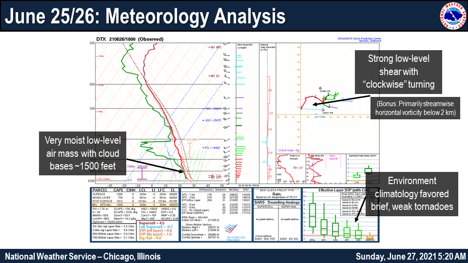
Environment
 |
||
| Upper air analysis of the June 26th environment |
Additional Info
 |
Media use of NWS Web News Stories is encouraged! Please acknowledge the NWS as the source of any news information accessed from this site. Additional recaps can be found on the NWS Chicago Past Events Page |
|


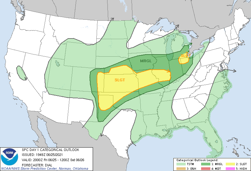
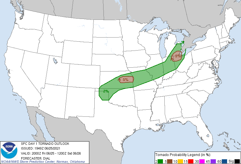 Severe Weather Outlook tornado probabilities for the evening of Friday, June 25th. Issued Friday afternoon.
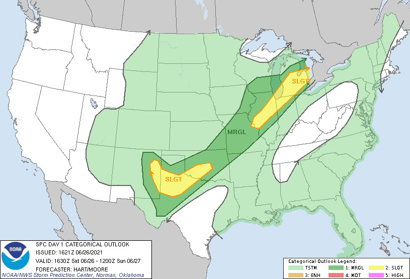
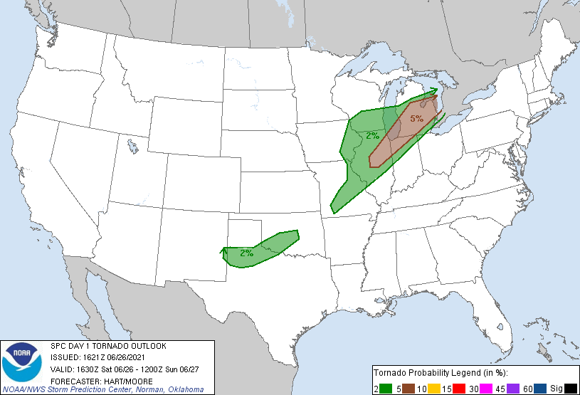 Severe Weather Outlook tornado probabilities for Saturday, June 26th. Issued Saturday morning.