Record setting heat is expected over the next several days from the Intermountain West through the northern Plains. Furthermore, fire weather concerns increase with dry and breezy conditions. Meanwhile, heavy rainfall and severe thunderstorm threats for the Ohio/Tennessee Valleys, central Appalachians and Southeast today. The threat shifts to central Gulf Coast and across central Texas this week. Read More >
|
|
Overview
Meteorological Glossary:
More information on different severe weather types and terms can be found here.
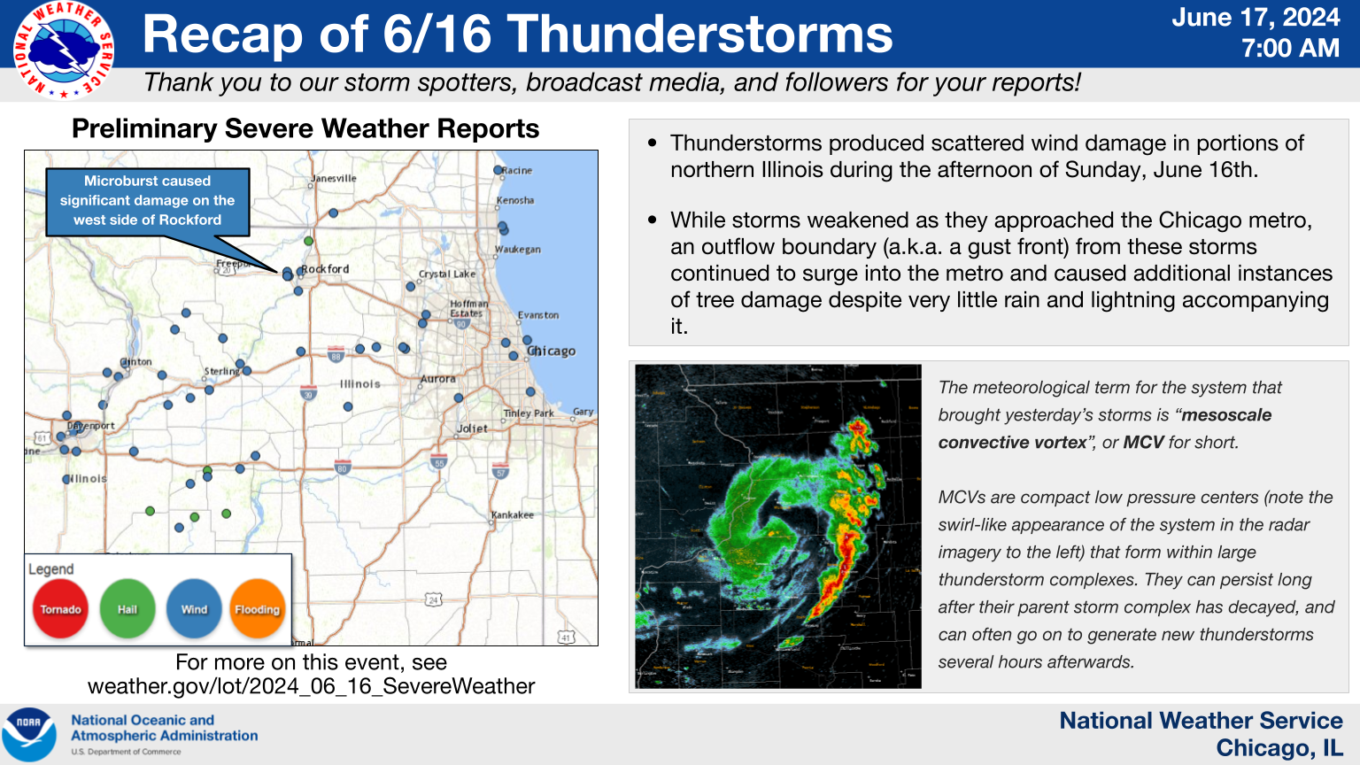
Storm Reports
|
Preliminary Storm Report Map |
 |
 |
| Wind damage in Rockford. Photo courtesy of the Winnebago County Emergency Management Agency. | Wind damage in Rockford. Photo courtesy of the Winnebago County Emergency Management Agency. |
Preliminary Local Storm Report...Summary
National Weather Service Chicago IL
536 AM CDT Mon Jun 17 2024
..TIME... ...EVENT... ...CITY LOCATION... ...LAT.LON...
..DATE... ....MAG.... ..COUNTY LOCATION..ST.. ...SOURCE....
..REMARKS..
0316 PM Tstm Wnd Dmg Polo 41.98N 89.58W
06/16/2024 Ogle IL Public
A few 3-5 inch diameter tree limbs were
downed in Polo. Time estimated from radar.
0317 PM Tstm Wnd Gst 3 ESE Dixon 41.83N 89.43W
06/16/2024 M54 MPH Lee IL Mesonet
Mesonet station UR568 Dixon2.
0325 PM Tstm Wnd Dmg 1 NNE Dixon 41.86N 89.47W
06/16/2024 Lee IL Broadcast Media
Picture of downed tree relayed to us from a
viewer.
0352 PM Tstm Wnd Gst Rockford Airport 42.20N 89.10W
06/16/2024 M53 MPH Winnebago IL ASOS
KRFD ASOS peak gust.
0356 PM Tstm Wnd Dmg 1 NNE Rockford 42.29N 89.08W
06/16/2024 Winnebago IL Trained Spotter
Report of a 5 to 6 inch diameter tree limb
down near North Main Street and Auburn in
Rockford.
0356 PM Tstm Wnd Dmg 4 ENE Winnebago 42.29N 89.17W
06/16/2024 Winnebago IL Broadcast Media
Report of a 6 to 7 inch diameter tree limb
down at WIFR in Rockford. Time estimated
from radar.
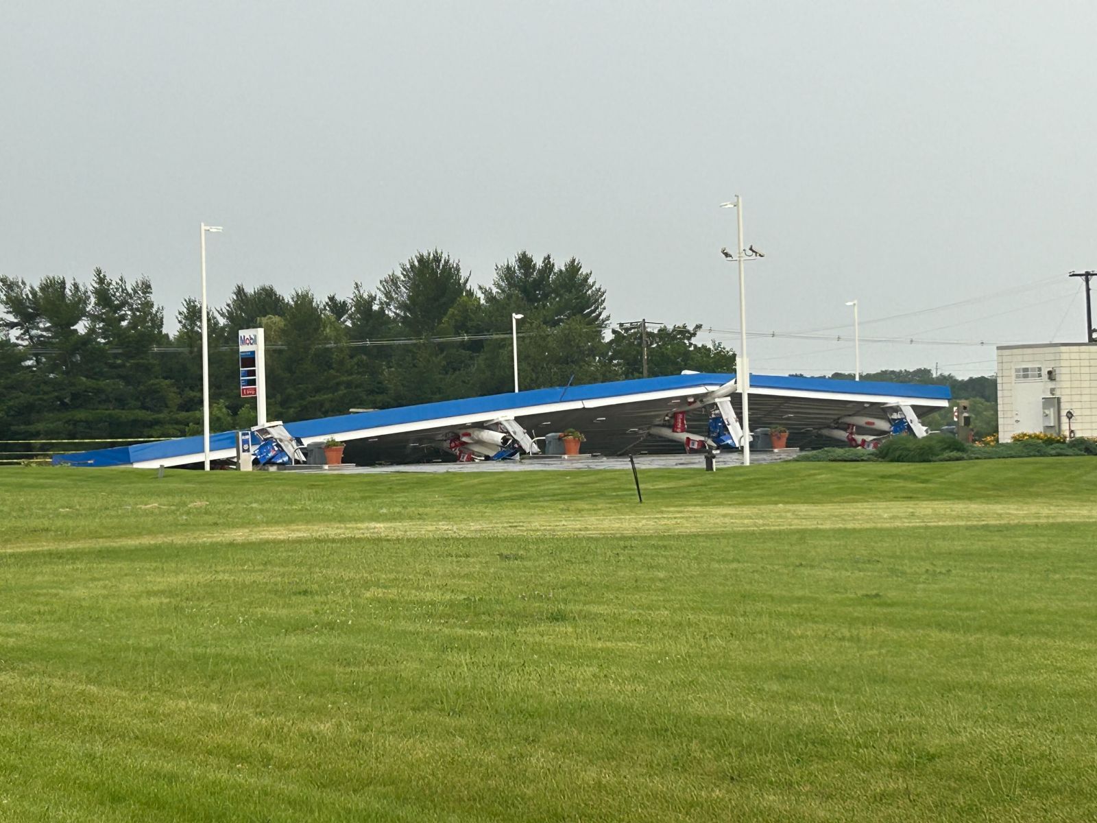
0359 PM Tstm Wnd Dmg 3 E Winnebago 42.27N 89.17W
06/16/2024 Winnebago IL Broadcast Media
Corrects previous tstm wnd dmg report from 3
E Winnebago. Mobil gas station canopy
collapsed at US 20 and Meridian Road on the
far west side of Rockford.
0402 PM Tstm Wnd Dmg 4 E Winnebago 42.27N 89.17W
06/16/2024 Winnebago IL Emergency Mngr
Pictures received of numerous trees and
power lines down in the Parker Wood
Subdivision. Time estimated from radar.
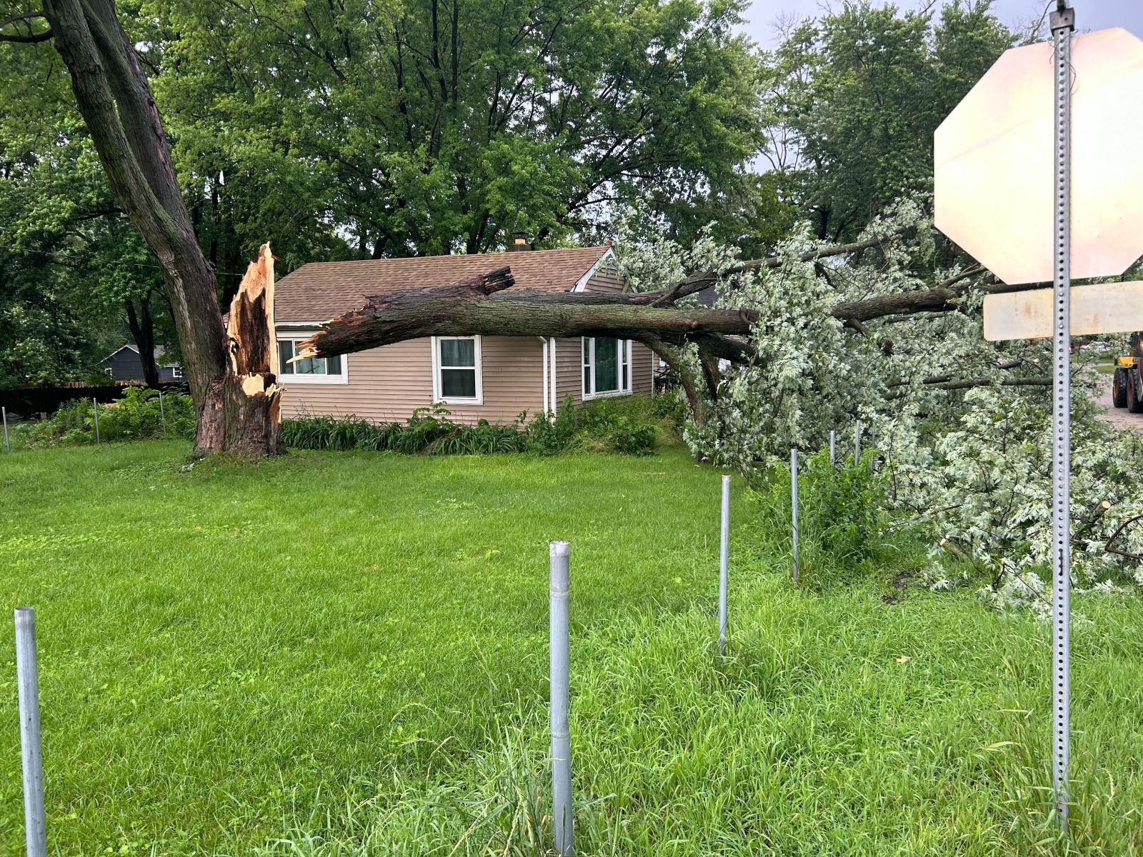
0404 PM Tstm Wnd Dmg 3 W Rockford 42.27N 89.16W
06/16/2024 Winnebago IL Emergency Mngr
Pictures received of a large tree down on
the side of a home. Time estimated from
radar.
0408 PM Tstm Wnd Gst 3 NNE Leland 41.66N 88.78W
06/16/2024 M58 MPH De Kalb IL Mesonet
Ambient Weather station WS2902 recorded a
58.2 mph gust associated with thunderstorm
outflow.
0410 PM Tstm Wnd Dmg Rochelle 41.92N 89.08W
06/16/2024 Ogle IL Trained Spotter
Report of 5 inch diameter branch down on a
home causing damage to the porch.
0415 PM Tstm Wnd Gst 1 NNW Cortland 41.93N 88.70W
06/16/2024 M52 MPH De Kalb IL AWOS
KDKB AWOS peak gust.
0415 PM Tstm Wnd Dmg 2 N Maple Park 41.94N 88.60W
06/16/2024 Kane IL Emergency Mngr
Report of trees down blocking both lanes of
traffic on west County Line Road at Winters
Road in Maple Park. Time estimated from
radar.
0416 PM Hail 2 NW Roscoe 42.43N 89.03W
06/16/2024 U0.50 Inch Winnebago IL Public
From mPING.
0425 PM Blowing Dust 1 N Lily Lake 41.96N 88.48W
06/16/2024 Kane IL Public
Strong gust front caused lots of blowing
dust and significantly reduced visibility
for about 10 minutes. Peak measured wind
gust 49 mph.
0427 PM Tstm Wnd Dmg 2 W Campton Hills 41.94N 88.43W
06/16/2024 Kane IL Emergency Mngr
Report of trees and power lines down on
Circle drive in Campton Hills. Time
estimated from radar.
0431 PM Tstm Wnd Dmg 1 SW Campton Hills 41.93N 88.41W
06/16/2024 Kane IL Emergency Mngr
*** 1 INJ ***
Report that a tree fell on a child resulting
in an injury. Time estimated from radar.
0438 PM Tstm Wnd Dmg 1 NW Elgin 42.05N 88.30W
06/16/2024 Kane IL Emergency Mngr
Report of a large tree blocking Buckeye
Street in Elgin. Time estimated from radar.
0445 PM Tstm Wnd Dmg Lakewood 42.22N 88.38W
06/16/2024 McHenry IL Public
Trees downed.
0447 PM Tstm Wnd Dmg 1 SSW West Dundee 42.09N 88.28W
06/16/2024 Kane IL Emergency Mngr
Multiple reports of down power lines and
power outages near the Elgin, West Dundee,
and Carpentersville areas. Time estimated
from radar.
0506 PM Tstm Wnd Dmg Bolingbrook 41.70N 88.07W
06/16/2024 Will IL Public
Report of 8 inch diameter tree limb snapped.
Time estimated from radar.
0525 PM Tstm Wnd Dmg Humboldt Park - Chicago 41.90N 87.72W
06/16/2024 Cook IL 911 Call Center
Numerous trees and large branches down in
the west Humboldt Park neighborhood.
0530 PM Tstm Wnd Dmg 1 NW Portage Park - Chi 41.96N 87.77W
06/16/2024 Cook IL 911 Call Center
Numerous downed trees/large branches in the
Jefferson Park and Portage Park
neighborhoods.
0537 PM Tstm Wnd Gst 1 NE Montrose Harbor 41.97N 87.63W
06/16/2024 M47 MPH LMZ741 IL Mesonet
Corrects previous tstm wnd gst report from 1
NE Montrose Harbor. Mesonet station XMTB
Montrose Beach Light measured a 41 kt (47
mph) wind gust.
0540 PM Tstm Wnd Gst 2 E Winthrop Harbor 42.48N 87.78W
06/16/2024 M40 MPH LMZ740 IL Buoy
0544 PM Tstm Wnd Gst 3 NE Navy Pier 41.92N 87.57W
06/16/2024 M49 MPH LMZ741 IL Mesonet
Mesonet station CHII2 Harrison-Dever Crib
measured a 43 kt (49 mph) wind gust.
0545 PM Tstm Wnd Dmg 1 SSE Chatham - Chicago 41.73N 87.61W
06/16/2024 Cook IL 911 Call Center
Several trees/large branches down in Chatham
and Burnside neighborhoods.
|
 |
Media use of NWS Web News Stories is encouraged! Please acknowledge the NWS as the source of any news information accessed from this site. Additional recaps can be found on the NWS Chicago Past Events Page |
|