
Heat expands across the Desert Southwest, Plains, Mississippi Valley and Midwest into Monday. Fire weather concerns continue for portions of the Intermountain West. Active monsoonal moisture fuels thunderstorms over the Southwest with possible flash flooding. Tropical cyclone Fausto in the Pacific, should weaken as it approaches Hawaii; Dangerous surf, swells and rip currents are expected. Read More >
|
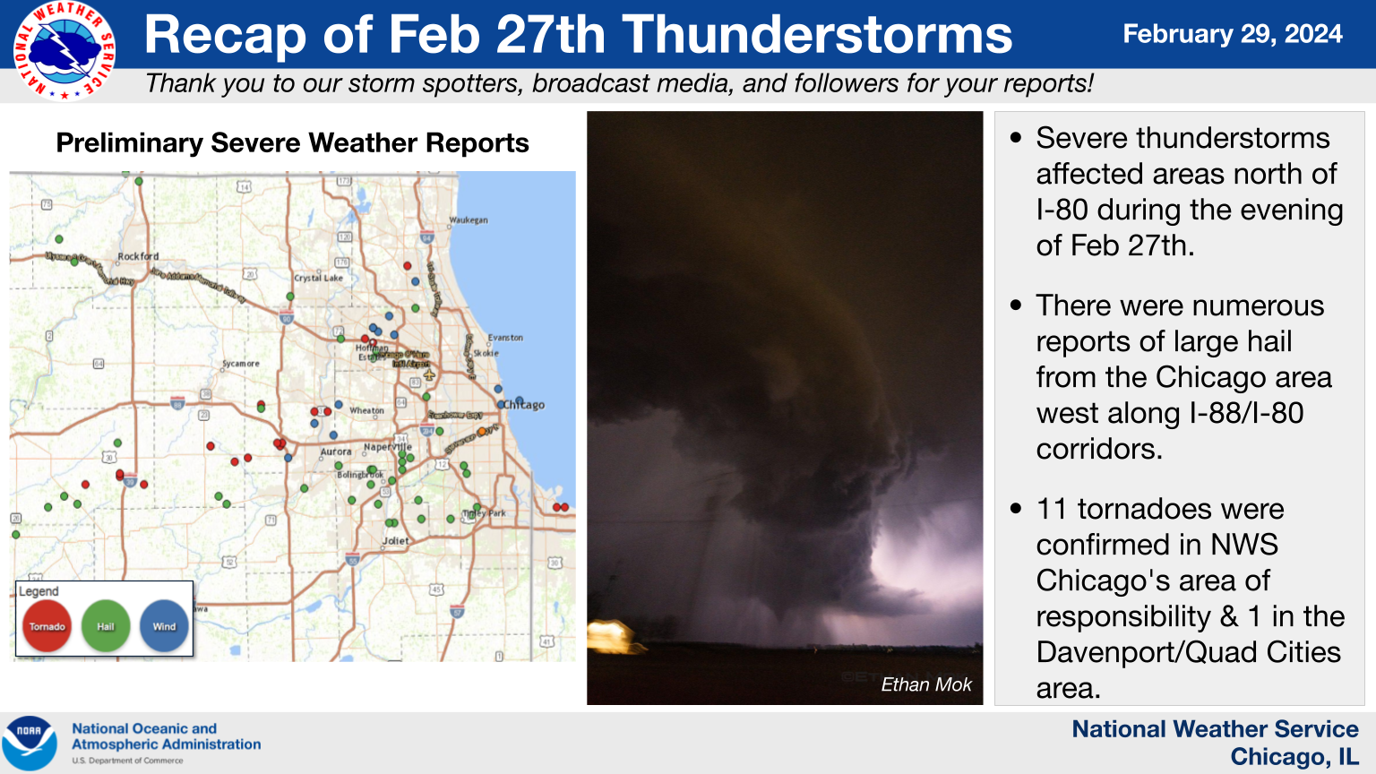
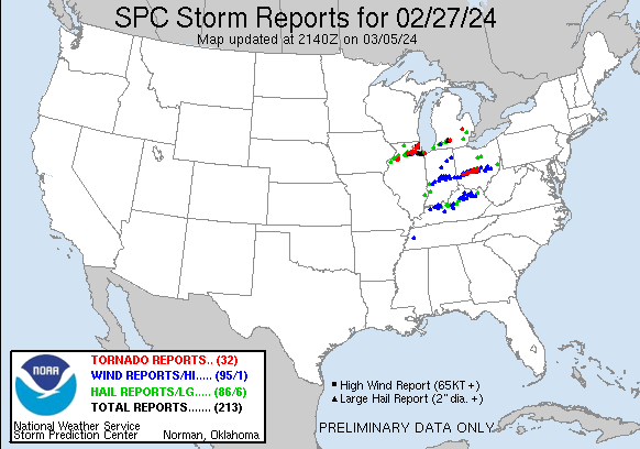
Summary of February 27, 2024 Severe Weather Reports |
|
Summary of February 27, 2024 Tornado Tracks |
Fast Facts
Following summer-like, record warmth, severe thunderstorms developed in the late afternoon of Tuesday, February 27th over northwest Illinois and spread east through the evening across the Chicago metro area.
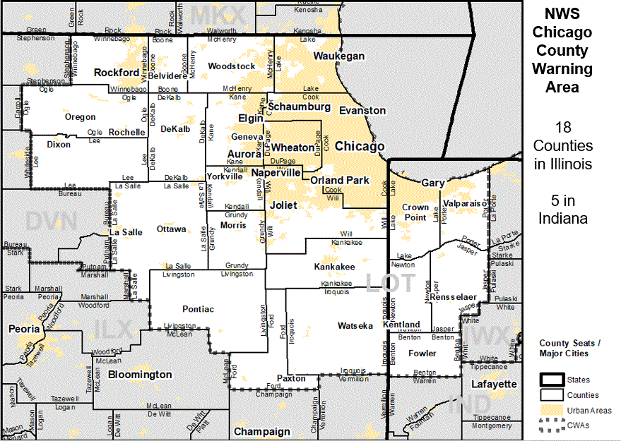
A total of 11 tornadoes touched down in Illinois and 1 in Indiana. There were 11 tornadoes in total across the NWS Chicago area of responsibility, which is the most in a February event since official NWS tornado records began in 1950.
This was only the fourth time on record that tornadoes were observed in the NWS Chicago forecast area in February (1 tornado occurred on 2/16/2006, 7 tornadoes occurred on 2/28/2017, and 3 tornadoes occurred just last year on 2/27/2023).
Large hail was observed in several locations as the storms passed through the area. The largest reported hailstones were 2-2.5" in diameter.
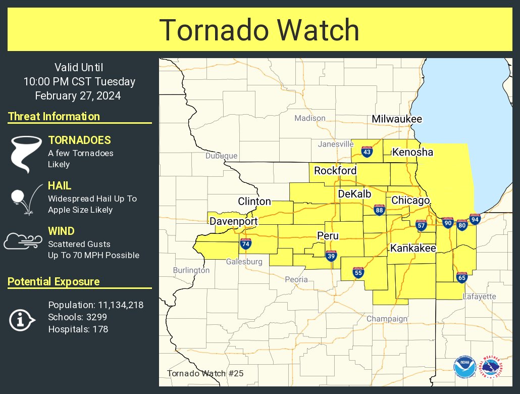
A Tornado Watch was issued at 3:54 PM CST from the Quad Cities area across the NWS Chicago forecast area and far southeast Wisconsin. Thereafter, NWS Chicago issued several Tornado Warnings and Severe Thunderstorm Warnings as it became clear as to which locations would be impacted by tornadoes, severe winds, and/or large hail.
|
Tornado Watch issued at 3:54 PM CST |
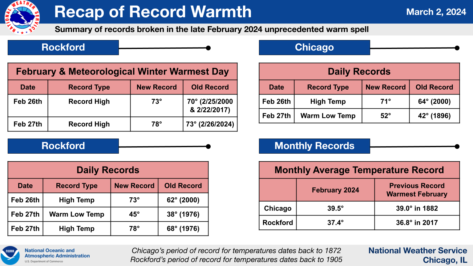
The severe weather came on the heels of record warm temperatures that were observed on the 26th and 27th. Chicago set two new daily temperature records, while Rockford set three during this two-day stretch.
Rockford not only set new daily high temperature records, but also broke its all-time warmest temperature record for both February and meteorological winter on consecutive days -- first breaking these records with a high temperature of 73°F on the 26th and then superseding that on the 27th with a high temperature of 78°F!
This warmth capped what was the warmest February on record for both Chicago and Rockford (and one of the warmest winters on record for both cities as well).
|
Graphic summarizing the record warmth observed at the end of February |
Temperatures also plummeted Tuesday night behind a strong cold front, falling 54 degrees and 60 degrees in Chicago and Rockford, respectively, in less than 24 hours -- one of the largest 24-hour temperature drops observed at both locations.
Tornadoes
Below is a summary of all 12 tornadoes that were confirmed in northern Illinois and northwest Indiana during this severe weather event. An interactive map with all of these tornado tracks can be found on our Damage Assessment Toolkit Viewer website (change the date range in the top right corner to include 2/27/2024 to see tornadoes from this event). Instructions for how to download survey data (KMZ and shapefiles) are available here.
Downloadable KMZ file with all storm survey data
Downloadable shapefile with all storm survey data
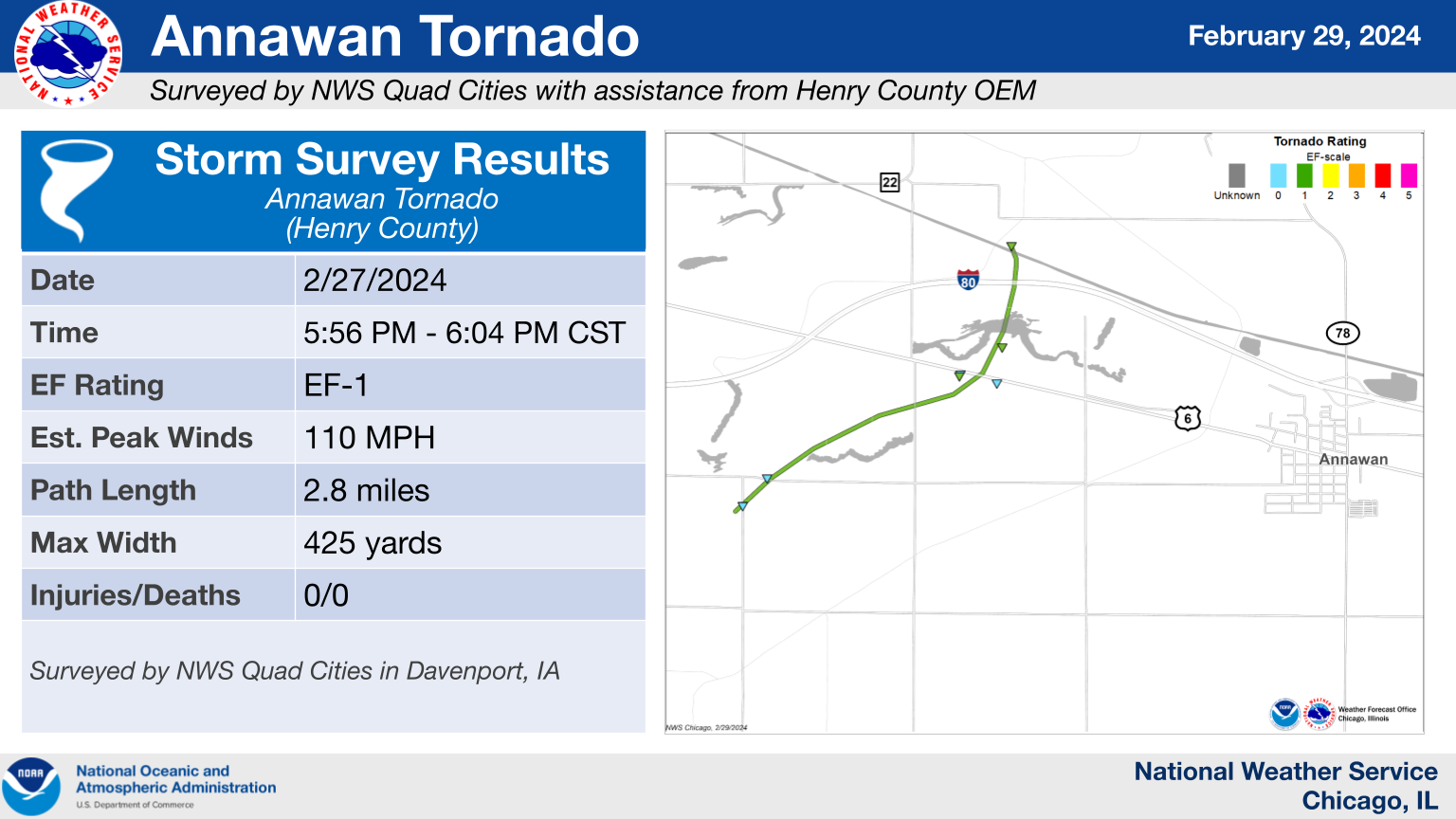
1.) Annawan, IL Tornado
|
(click on image to enlarge) |
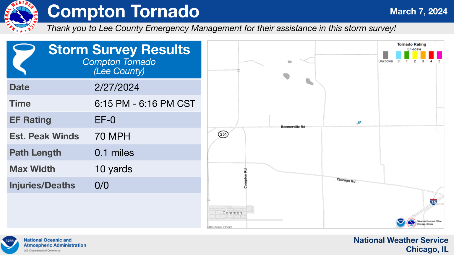
2.) Compton, IL Tornado
|
(click on image to enlarge) A brief tornado, which was sighted by storm chasers, touched down along Beemerville Road northeast of Compton and caused roof damage to a farm outbuilding. |
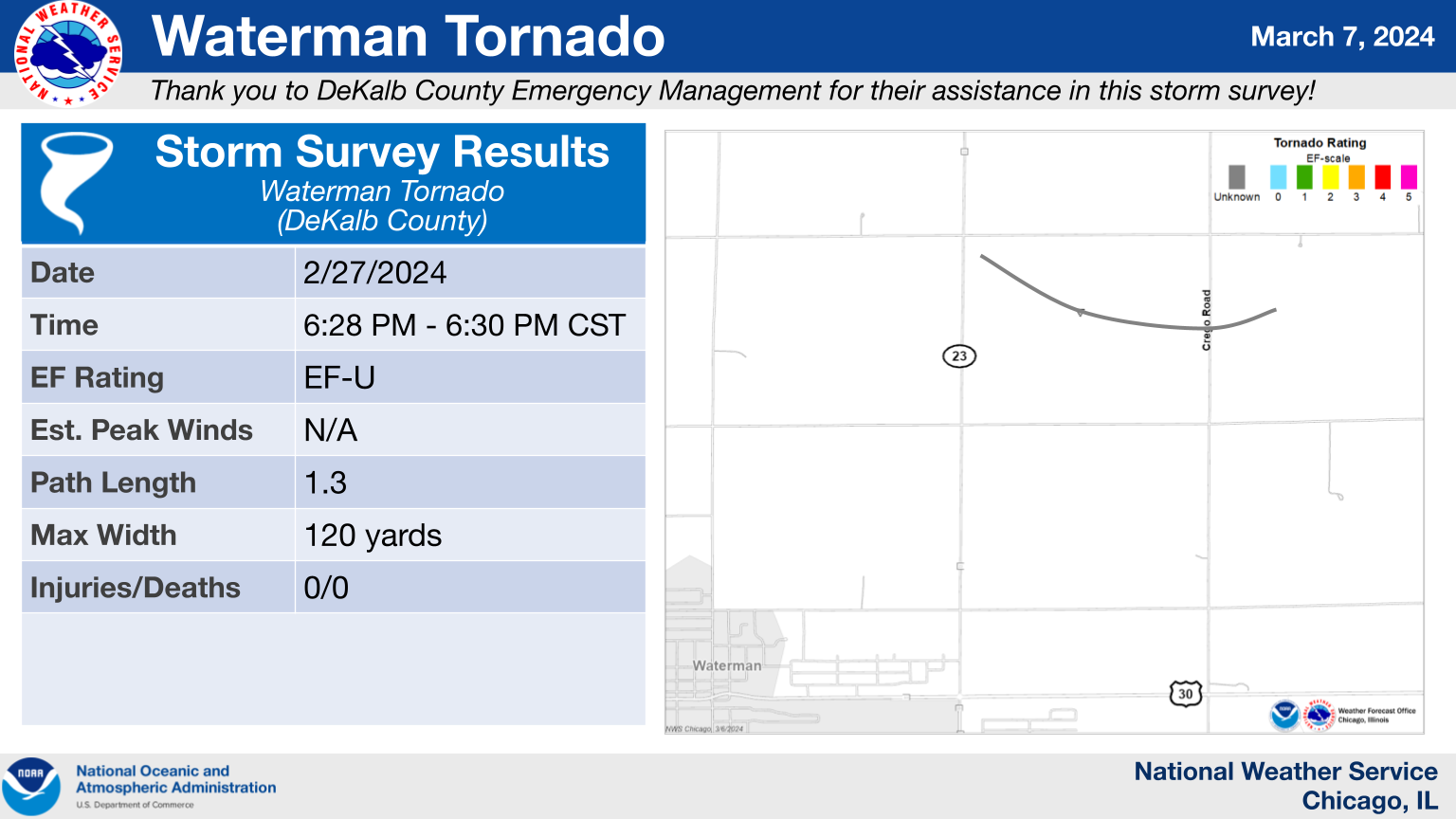
3.) Waterman, IL Tornado
|
(click on image to enlarge) High resolution satellite imagery shows a ground swirl pattern in a field beginning near Miller Road and IL-23. The track moved through a field to the southeast, then turned to the east as it crossed Crego Road. The tornado lifted just east of Crego Road. Because this tornado did not impact any buildings or trees, no intensity estimates could be made, and thus, this tornado was assigned an EF-U (EF-Unknown) rating. |
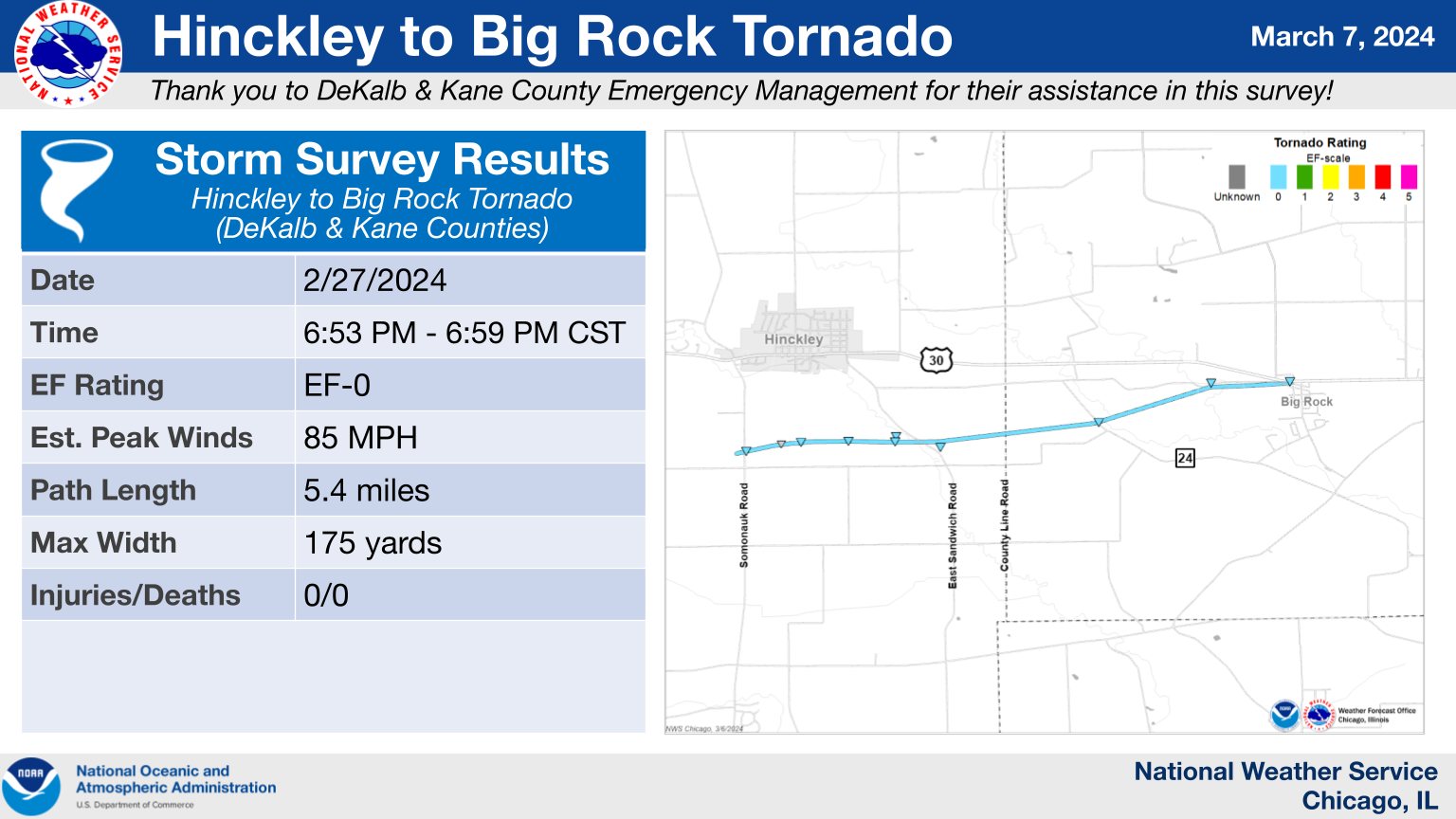
4.) Hinckley to Big Rock, IL Tornado
|
(click on image to enlarge) Storm chasers documented a tornado touching down in a field south of Hinckley near Somonauk Road and Bastian Road. High resolution satellite imagery shows that this tornado first moved to the northeast mostly in open fields, but likely caused tree damage to properties just north of Bastian Road. The tornado then turned to the east and caused damage to multiple farm outbuildings, peeled shingles off of roofs, and caused tree damage before lifting as it tracked into Big Rock. |
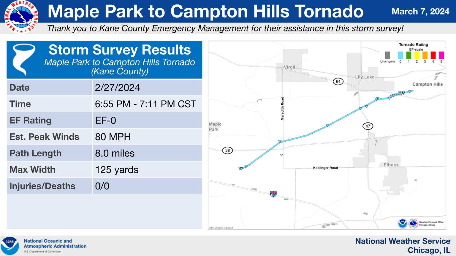
5.) Maple Park to Campton Hills, IL Tornado
|
(click on image to enlarge) This tornado touched down along Keslinger Road just west of Watson Road between Maple Park and Elburn. The tornado then may have lifted intermittently as it approached, crossed, and then eventually paralleled Route 38 before sustaining itself on the ground as it tracked northeast into the southwest side of Campton Hills. The path of the tornado was characterized by damage to trees, a grain elevator, a windmill, and building roofing. The tornadic damage was consistent with an EF-0 rating with 80 mph winds. |
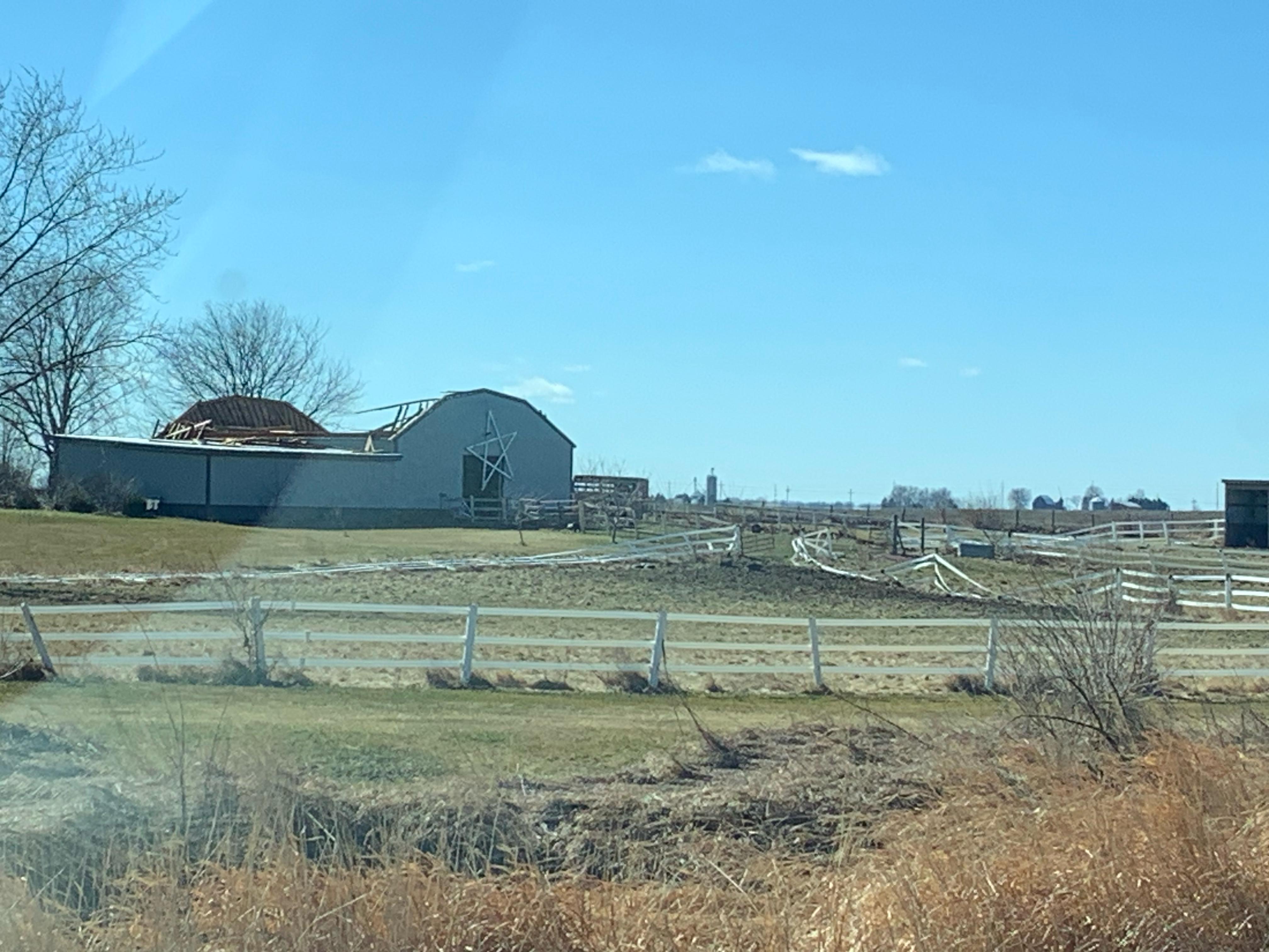
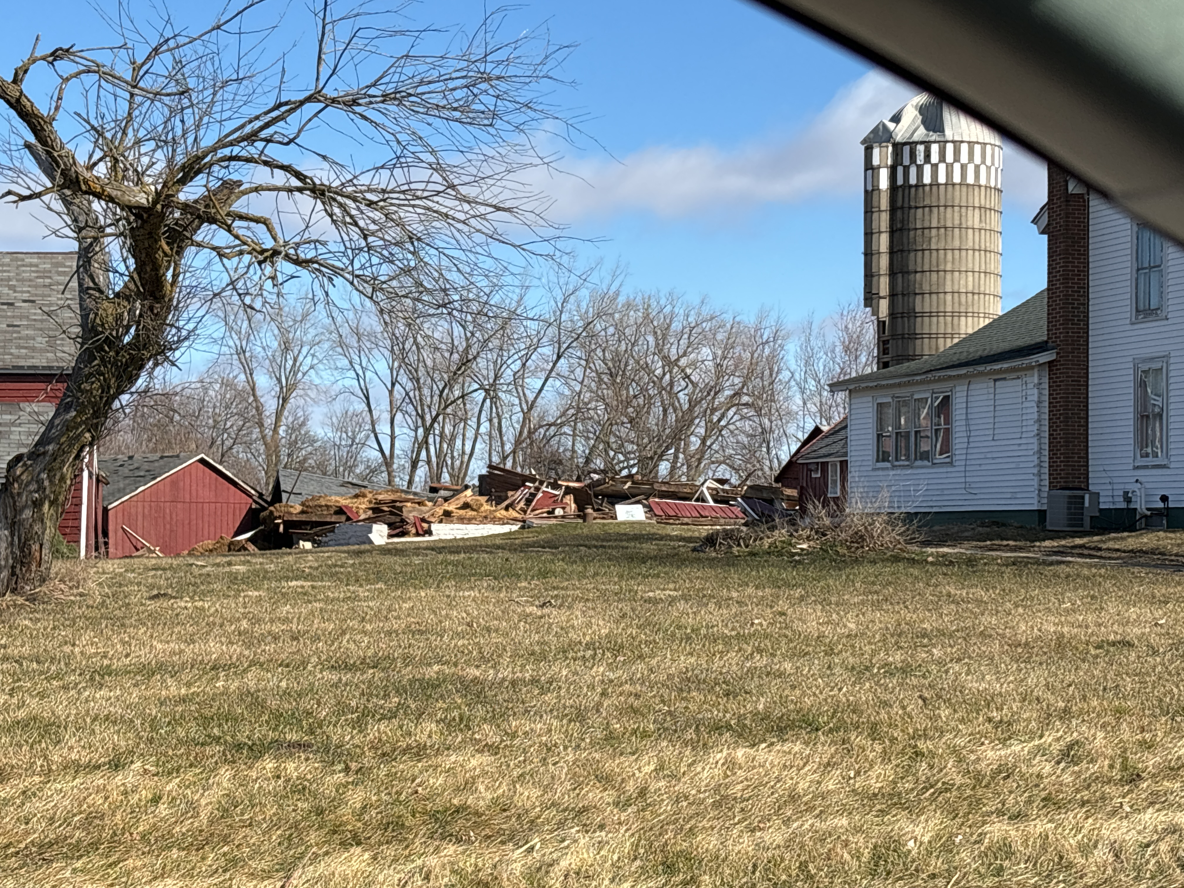
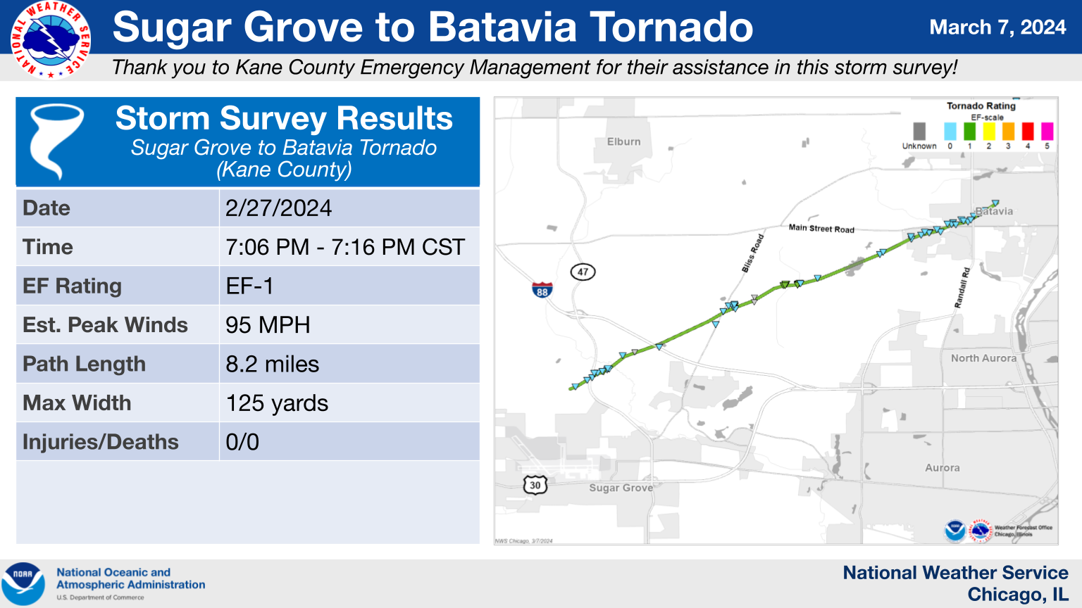
6.) Sugar Grove to Batavia, IL Tornado
|
(click on image to enlarge) This tornado touched down near Hartner Road southwest of Waubonsee Community College. Damage to trees was noted as the tornado moved northeast toward IL-47. The tornado then moved through the Waubonsee Community College property with damage to trees, signs, and one large parking lot light pole, with a width of approximately 80 yards. Minor tree damage occurred at a farm along Bliss Road. The tornado widened to its peak width of approximately 125 yards as it neared two farms on Seavey Road near Lake Run. At one farm, multiple evergreen trees were snapped 5-10 feet above ground level. Across the road, a large wooden barn was pushed off its foundation and collapsed, with minor damage to the roof of a nearby grain silo and some nearby trees. The tornado continued to the northeast along Lake Run, causing minor tree damage. The tornado then narrowed and weakened as it neared Nelson Lake Road, with only minor tree damage noted. The tornado entered the southwest side of Batavia and moved through a residential area along Alberosky Way and Hapner Way, causing damage to shingles at multiple houses and several small branches, covering a width of approximately 100 yards. Damage to trees continued along Saupp Drive and Deerpath Road, with street signs damaged. The tornado then crossed Main Street near Deerpath Road, with damage to industrial equipment noted, along with some nearby minor tree damage. The tornado moved into a commercial area near Wilson Street and Randall Road, causing some damage to signs and the roof covering of strip malls. Sporadic tree damage was observed as the tornado continued to the northeast, and the tornado appeared to dissipate near McKee Street and Western Avenue. |
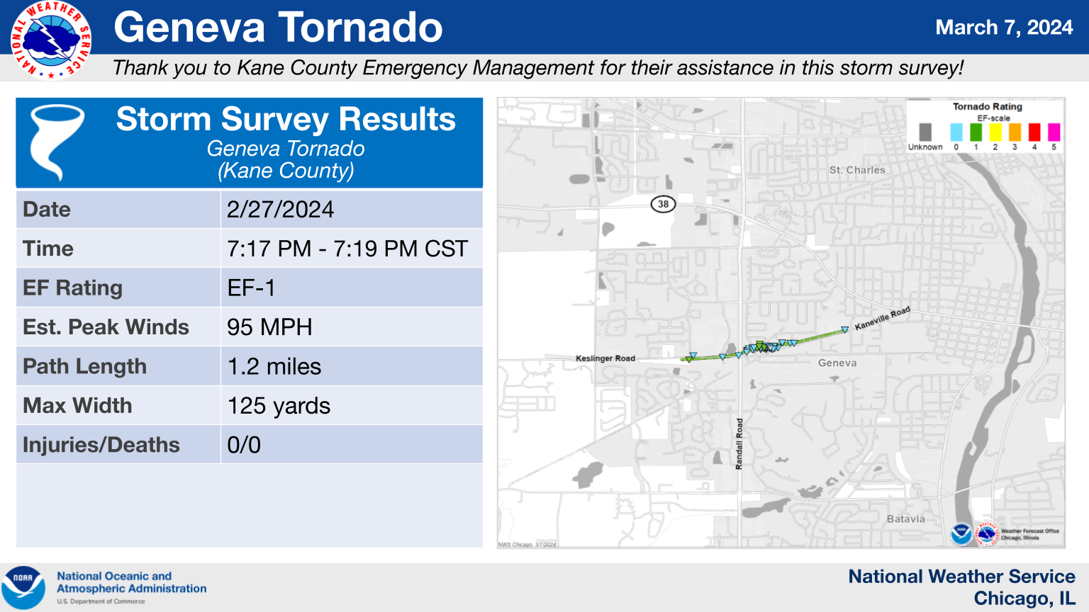
7.) Geneva, IL Tornado
|
(click on image to enlarge) This tornado touched down along Keslinger Road west of Randall Road in Geneva. The first instance of damage was noted to a metal garage/storage building, which had portions of roofing and walls damaged or removed and was shifted off its foundation. The structure did not appear to be properly anchored to its foundation. Trees and a traffic light were then damaged as the tornado crossed the intersection, with shingle, soffit, and siding damage noted at a commercial building before the tornado moved into a residential area. A concentrated corridor of damage consistent with EF-1 wind speeds near 95 mph occurred along Cambridge Drive and Essex Court, where damage to several roofs and windows was observed. In addition, nearby trees were significantly damaged with almost all large branches snapped. The tornado weakened and narrowed as it moved east just north of Kaneville Road, with tree damage noted until the tornado dissipated near Kaneville Road and Burgess Road. The tornado was on the ground for fewer than two minutes. |
8.) South Barrington/Hoffman Estates, IL Tornado #1
|
(click on image to enlarge)
This tornado touched down just west of Sutton Road and north of Golf Road in the Carl Hansen Woods of the Arthur L. Janura Preserve, initially producing tree damage and peeling part of the roof off of a picnic shelter. The tornado may have lifted temporarily as it tracked northeast through the preserve toward Bartlett Road and Shoe Factory Road, but access to these forest preserve areas was limited. Along Higgins Road, roof and fascia damage was noted to several buildings in an office complex before the tornado caused damage at Goebbert`s Farm across the road. In the subdivision to the northeast of the farm, a few trees were uprooted along Star Lane. The tornado then moved into The Glen subdivision, where it produced a swath of concentrated tree damage and damaged roofs and chimneys at a few residences as it reached its peak width. The tornado then produced tree damage along and north of Mundhank Road before it dissipated as it entered the Terra Vita Estates subdivision. |
9.) Hoffman Estates to Inverness, IL Tornado
|
(click on image to enlarge) This tornado touched down in the area near Della Drive in Hoffman Estates and tracked northeast, snapping tree branches, downing power lines along Hassell Road, and damaging shingles, fascia, and gutters on homes. The tornado then tracked across I-90 and entered the Paul Douglas Forest Preserve, where it snapped and uprooted several trees. The tornado then exited the forest preserve and entered the subdivision to the northwest of Algonquin Road and Ela Road, where it caused roof, soffit, and fascia damage to several residences. Shortly thereafter, the tornado lifted as it entered Inverness. |
10.) South Barrington/Hoffman Estates, IL Tornado #2
|
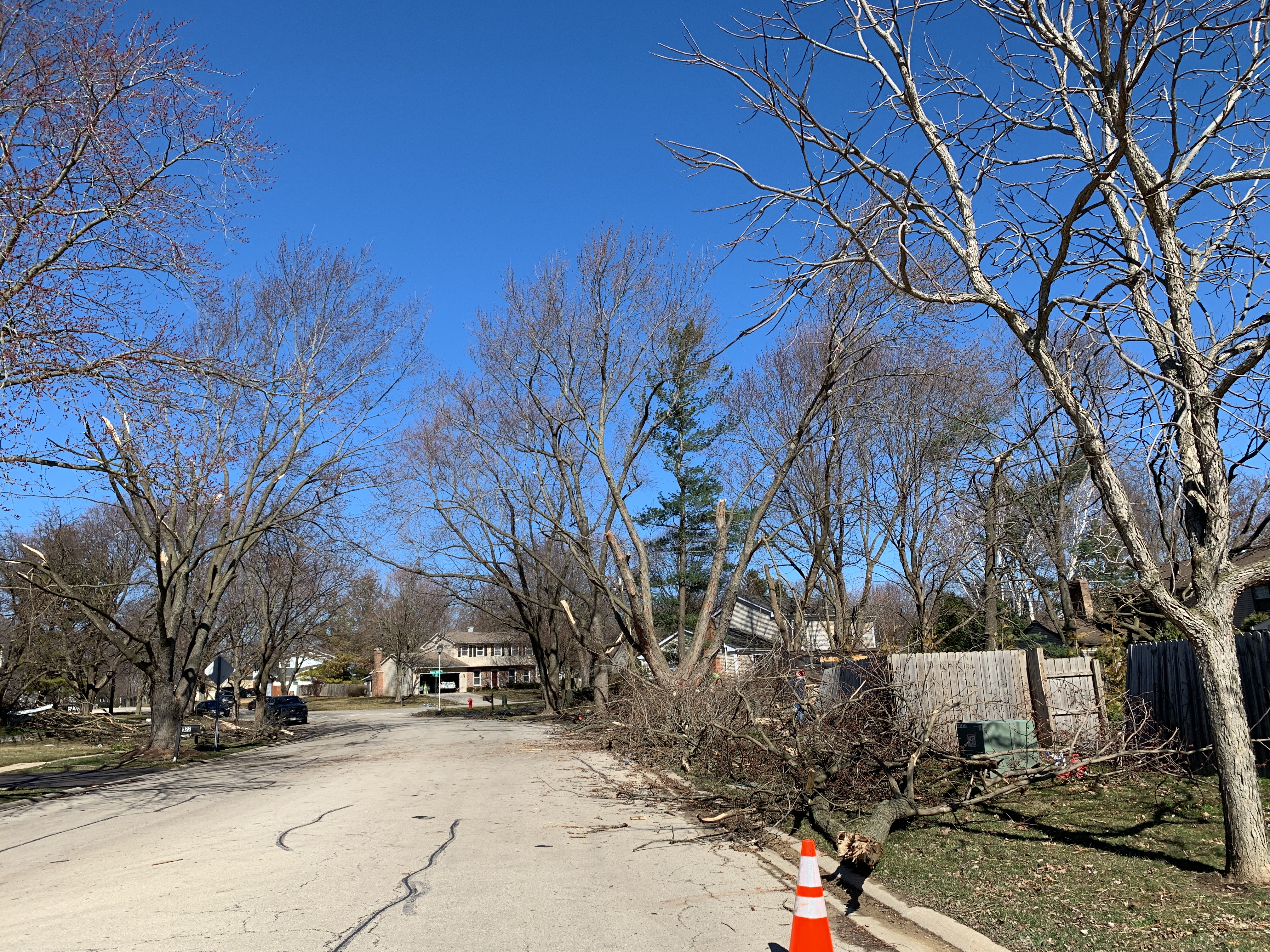
(click on image to enlarge) This tornado formed near Studio Drive in South Barrington, with the first damage observed at the South Barrington Tennis Club. The tornado moved northeastward through eastern sections of The Glen subdivision, producing sporadic tree damage. As the tornado crossed Barrington Road near Mundhank Road, significant tree damage occurred, with numerous branches and trunks snapped. The tornado continued northeast toward Willow Creek Church, where it uprooted at least one tree and damaged metal bus shelters. Damage became less severe as the tornado neared Algonquin Road, but increased again as the tornado turned to the east toward Whispering Trails Drive and Huntington Boulevard in Hoffman Estates. Damage was noted to residences along Chesapeake Court, Fir Court, and Crimson Drive with two residences losing a significant amount of roofing material. Other homes in the neighborhood had shingle damage, and a window was damaged at another residence. Tree damage, including broken limbs, was also observed. Roofing material removed from a home on Fir Court was deposited to the northwest, with plywood impaled into the ground and other debris penetrating the wall of a house, ending up in its living room. The tornado dissipated near Crimson Drive in Hoffman Estates. |
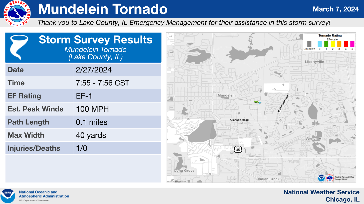
11.) Mundelein, IL Tornado
|
(click on image to enlarge) This tornado had a very short path with damage confined primarily to a single two-story apartment building. Most of the roof was removed from the building, and a portion of the brick facade also collapsed when the roof was removed. Two large softwood trees in the parking lot east of the building were uprooted. Debris was deposited to the east across the street, where a few tree branches were also snapped. In the apartment building south of the main one that was damaged, a resident described seeing a second story glass patio door on the east side being pulled out and shattered by the winds. |
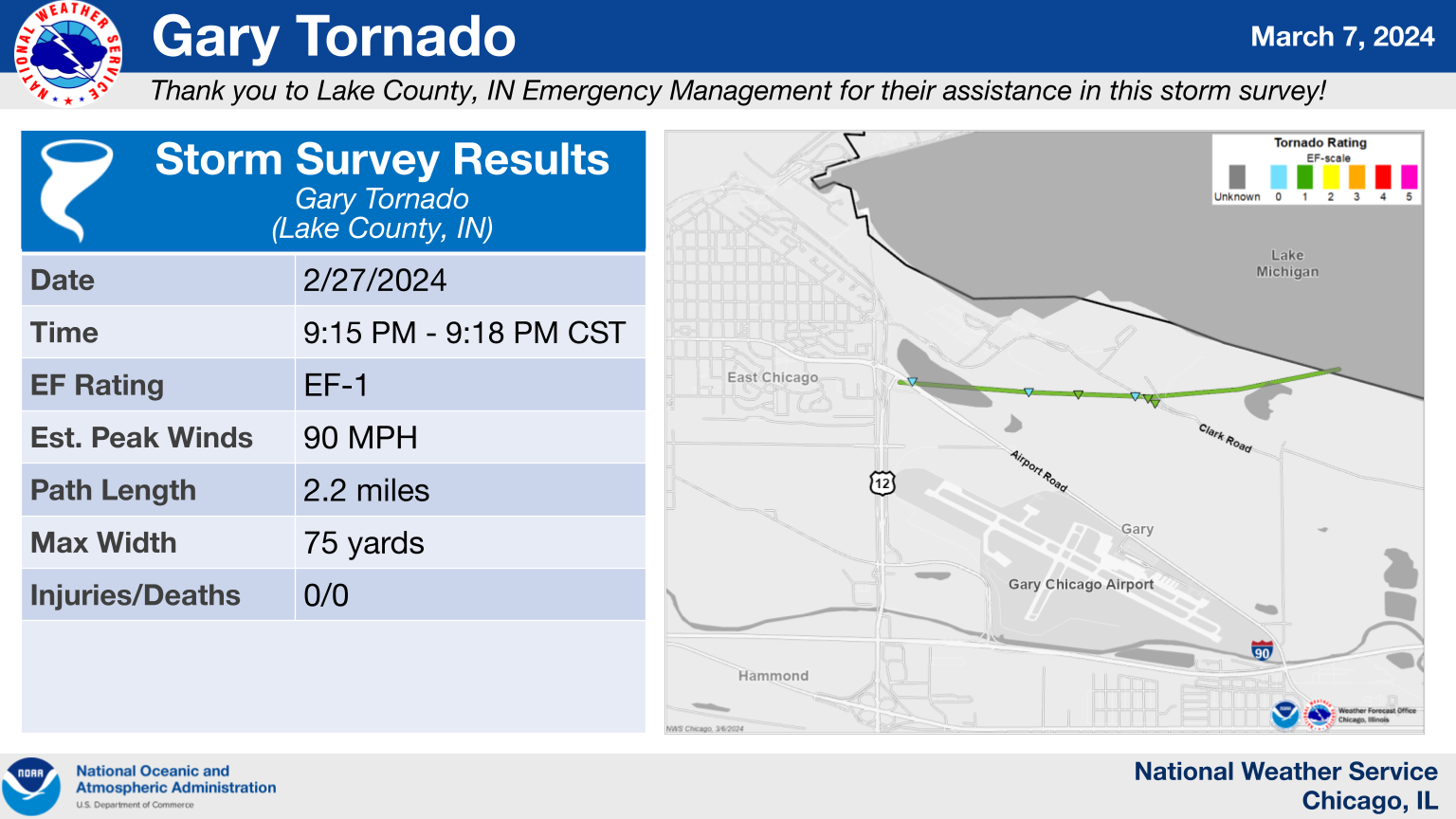
12.) Gary, IN Tornado
|
(click on image to enlarge) A tornado touched down near Cline Avenue and Industrial Highway just north of Gary Airport. The tornado moved eastward through a wooded industrial area and damaged multiple power poles, including snapping several that were relatively new. Snapped tree limbs were also observed along the path of the tornado. The tornado then turned east-northeast and moved offshore onto Lake Michigan. |
The Enhanced Fujita (EF) Scale classifies tornadoes into the following categories:
| EF0 Weak 65-85 mph |
EF1 Moderate 86-110 mph |
EF2 Significant 111-135 mph |
EF3 Severe 136-165 mph |
EF4 Extreme 166-200 mph |
EF5 Catastrophic 200+ mph |
 |
|||||
When a tornado is known to have occurred but does not cause damage to any qualified damage indicators, or if the only damage is located in an area that is inaccessible to NWS storm survey personnel, then a tornado may be assigned the EF-Unknown (EF-U) rating.
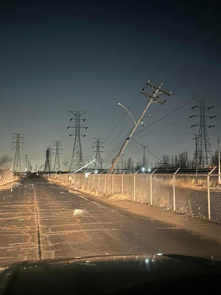
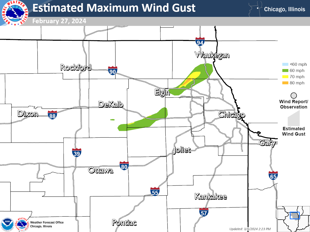
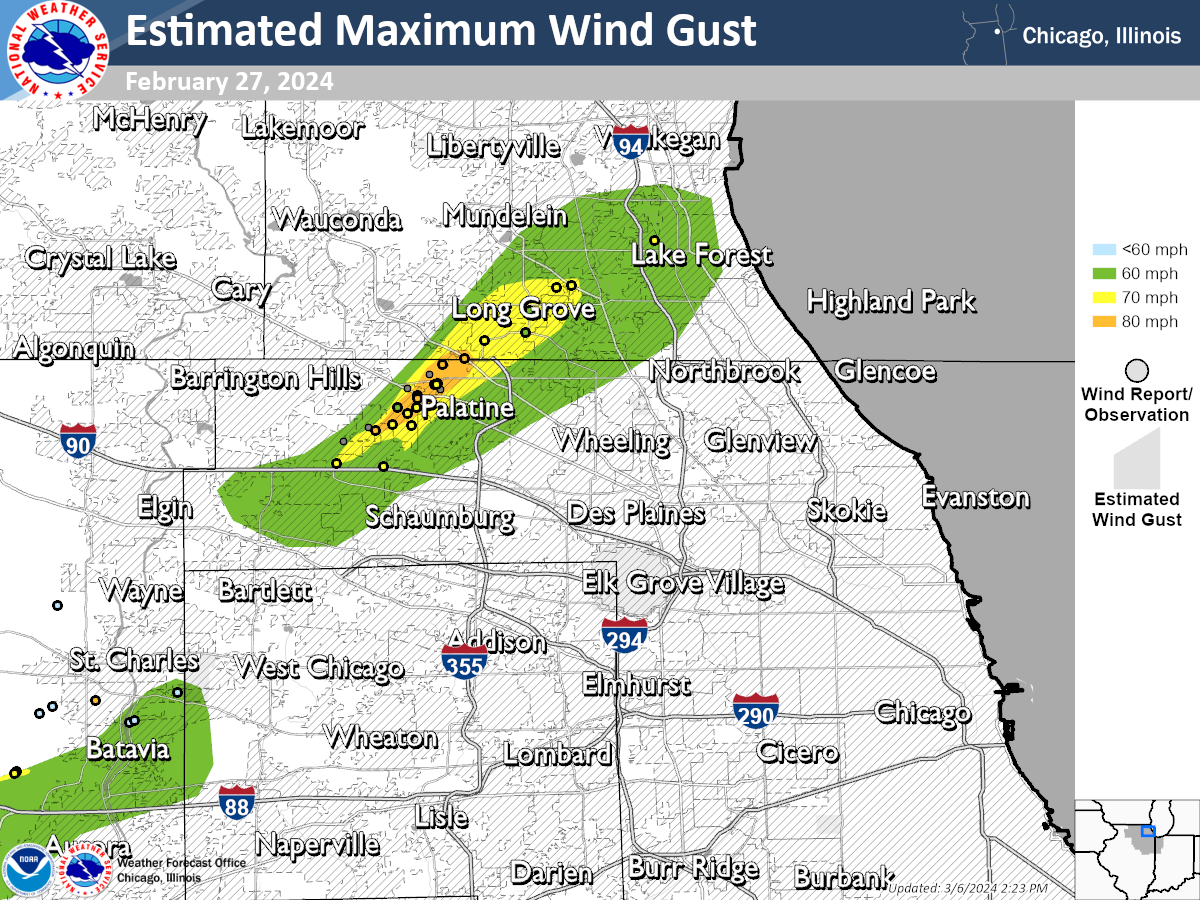
Straight-Line Winds
|
|
|
Multiple areas of straight-line winds occurred with the storms of February 27, 2024. The most notable area of straight-line winds occurred in northwestern Cook County and southern Lake County, with a narrow corridor of peak winds estimated at about 80 mph. Numerous instances of damage to trees and shingles were observed in this corridor, which covered a larger area than what was impacted by the tornadoes. The highest measured wind gust of 82 mph occurred just to the northwest of Palatine.
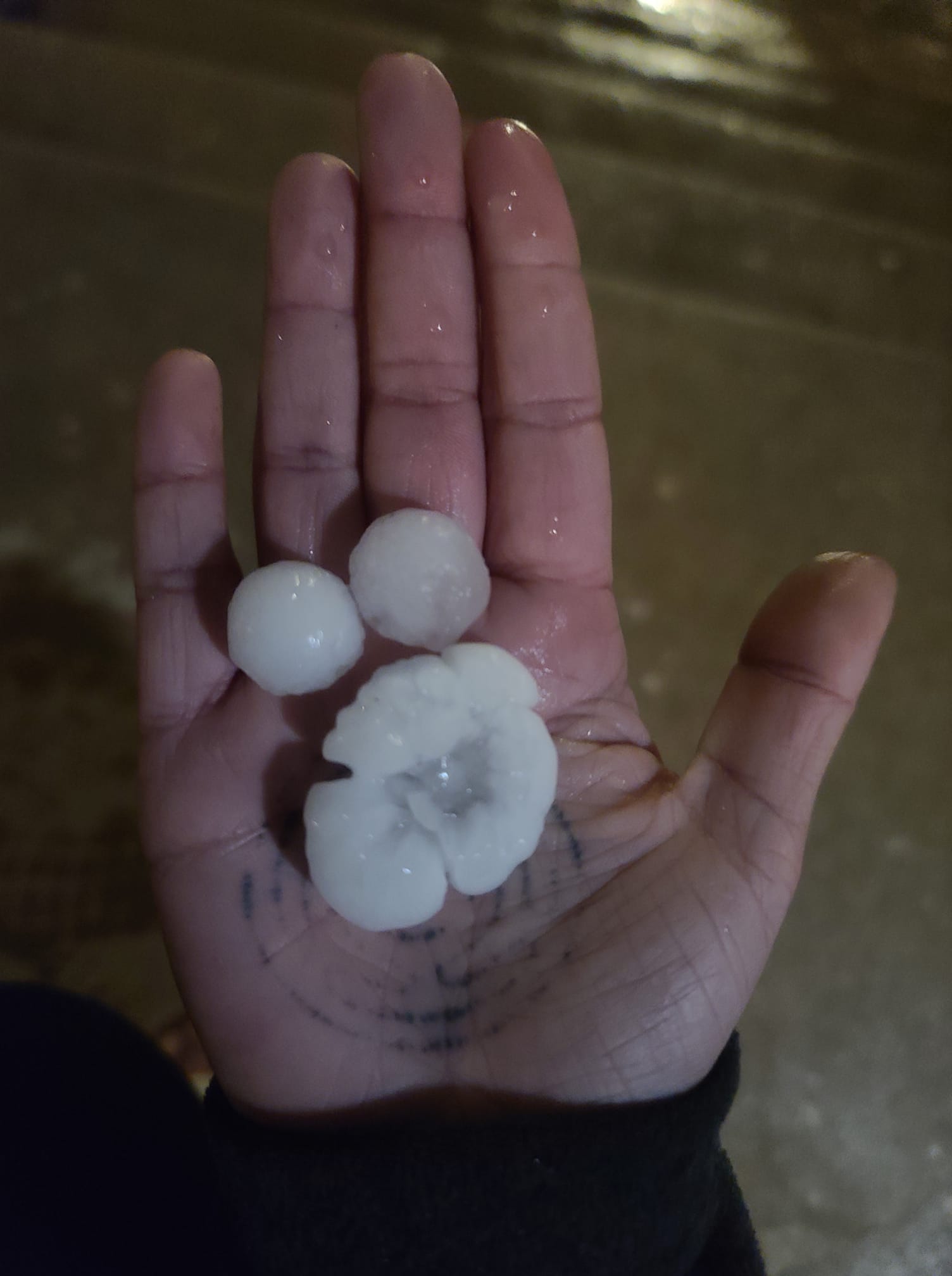
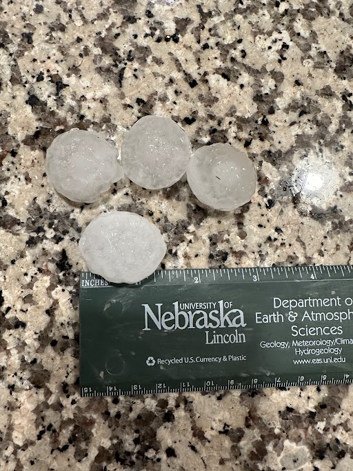
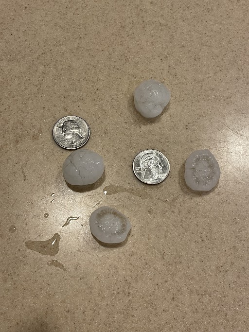
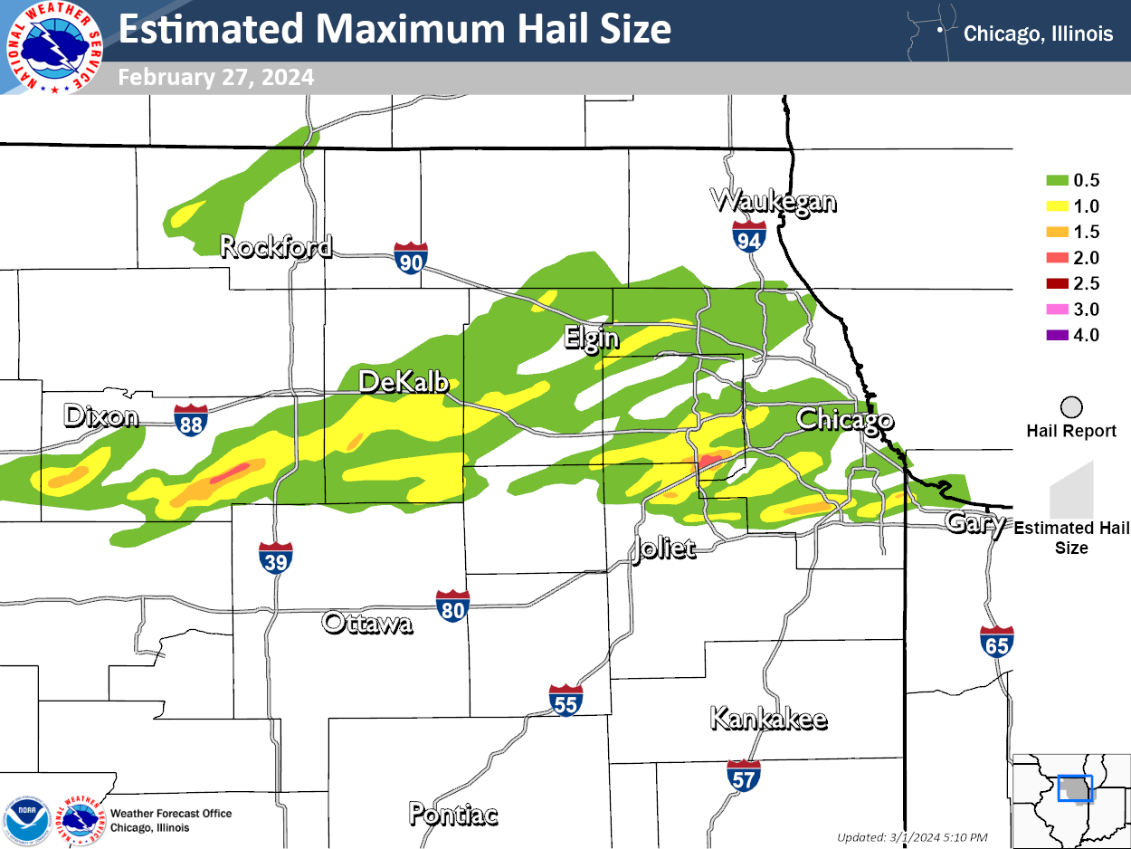
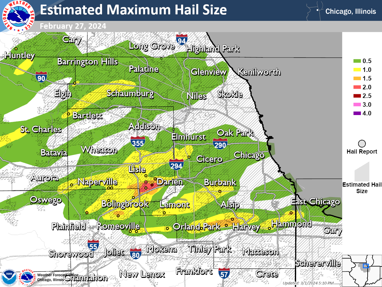
Hail
|
|
|
Hail was common with the storms of February 27, 2024. Although most areas experienced hail of quarter size (1 inch) diameter or smaller, a few narrow corridors of larger hail occurred. Notable hail corridors include the Amboy/Sublette areas, far southeastern DuPage County near Darien, and southern Cook County near Orland Park and Harvey. The largest hail was observed in the Darien and south Downers Grove areas where hail of 2.0 to 2.5 inches in diameter occurred.
Storm Reports
|
Preliminary storm reports from 2/27/2024 |
Preliminary Local Storm Report...Summary
National Weather Service Chicago IL
858 PM CST Fri Mar 1 2024
..TIME... ...EVENT... ...CITY LOCATION... ...LAT.LON...
..DATE... ....MAG.... ..COUNTY LOCATION..ST.. ...SOURCE....
..REMARKS..
0528 PM Hail 6 W Sublette 41.63N 89.34W
02/27/2024 E1.00 inch Lee IL Public
Relayed via mPING.
0557 PM Hail 4 SW Steward 41.80N 89.08W
02/27/2024 M1.50 inch Lee IL Trained Spotter
Ping pong ball sized hail.
0558 PM Funnel Cloud 3 W West Brooklyn 41.69N 89.20W
02/27/2024 Lee IL Storm Chaser
Photo shows funnel cloud between Sublette
and West Brooklyn. Observer was near IL-251
and Welland Road looking WNW at 558 PM.
0606 PM Hail 3 WNW Sublette 41.66N 89.28W
02/27/2024 M1.75 inch Lee IL Law Enforcement
Relayed via HAM radio operator. At least
golf ball sized hail.
0616 PM Hail Sublette 41.64N 89.23W
02/27/2024 M1.75 inch Lee IL Emergency Mngr
Photo of estimated golf ball size hail. Time
estimated.
0620 PM Funnel Cloud Paw Paw 41.69N 88.98W
02/27/2024 Lee IL Public
Multiple photos shared via social media show
funnel cloud near Paw Paw.
0637 PM Hail Shabbona 41.77N 88.87W
02/27/2024 M2.00 inch De Kalb IL Public
Photo shared via social media showing 2 inch
diameter hail in Shabbona. Time estimated
from radar.
0652 PM Hail Huntley 42.18N 88.43W
02/27/2024 M1.00 inch McHenry IL Public
Public report of quarter sized hail in
Huntley.
0655 PM Tstm Wnd Dmg 3 SW Big Rock 41.73N 88.59W
02/27/2024 Kane IL NWS Storm Survey
A couple of farm outbuildings and trees were
damaged near and southwest of Big Rock,
south of the path of the Hinckley to Big
Rock tornado. After footage from storm
chasers was reviewed and an NWS damage
survey was conducted, it was determined that
this damage was caused by straight-line
winds of up to 70 mph.
0701 PM Hail 2 NNW Somonauk 41.66N 88.70W
02/27/2024 E1.00 inch De Kalb IL Public
Near intersection of Council Rd and Suydam
Rd.
0705 PM Tstm Wnd Gst Sugar Grove 41.76N 88.44W
02/27/2024 M63 MPH Kane IL ASOS
Peak Gust 55 knots at KARR.
0705 PM Hail 3 ESE Maple Park 41.89N 88.54W
02/27/2024 E1.00 inch Kane IL Public
Relayed via mPING. Time estimated by radar.
0706 PM Tstm Wnd Dmg Elburn 41.89N 88.47W
02/27/2024 Kane IL Emergency Mngr
Fence panels and a large tree limb were
downed in Elburn. Time estimated from radar.
0706 PM Hail 1 ENE Somonauk 41.64N 88.67W
02/27/2024 E1.25 inch De Kalb IL Public
Relayed via mPING.
0715 PM Tstm Wnd Dmg 2 W Batavia 41.85N 88.34W
02/27/2024 Kane IL Emergency Mngr
Mobile office trailer within a construction
site in the Jewell Osco parking lot flipped
on its side. Shopping cart corrals also
blown around.
0724 PM Tstm Wnd Gst DuPage Airport 41.90N 88.25W
02/27/2024 M61 MPH DuPage IL ASOS
Measured gust to 53 knots at KDPA.
0725 PM Hail 1 N Wayne 41.97N 88.26W
02/27/2024 M1.00 inch Kane IL Public
Photo shared via social media showing 1 inch
diameter hail in Wayne. Time estimated from
radar.
0726 PM Hail 3 ENE Pecatonica 42.33N 89.30W
02/27/2024 M1.50 inch Winnebago IL Public
0728 PM Hail Winnebago 42.27N 89.24W
02/27/2024 M0.70 inch Winnebago IL Broadcast Media
Pea to dime size hail at WREX.
0728 PM Hail 1 W Oswego 41.68N 88.38W
02/27/2024 E0.88 inch Kendall IL Public
Nickel sized hail briefly occurred near
US-34 and Orchard Road in Oswego. Time
estimated by radar.
0730 PM Hail 3 SSE East Dundee 42.07N 88.24W
02/27/2024 E1.00 inch Cook IL Public
Relayed via mPING. Time estimated by radar.
0734 PM Hail 2 NE Hanover Park 42.02N 88.12W
02/27/2024 M0.88 inch Cook IL NWS Employee
NWS employee reported nickel sized hail in
Schaumburg near Schaumburg Road and
Springinsguth Road. Time estimated by radar.
0734 PM Hail 1 SSW Hoffman Estates 42.04N 88.11W
02/27/2024 E1.00 inch Cook IL Public
Relayed via mPING. Time estimated by radar.
0735 PM Tstm Wnd Dmg 1 W Schaumburg 42.03N 88.09W
02/27/2024 Cook IL Broadcast Media
Tree downed near the Schaumburg post office.
Time estimated from radar.
0737 PM Tstm Wnd Dmg 1 S Inverness 42.11N 88.09W
02/27/2024 Cook IL NWS Storm Survey
Widespread tree and powerline damage caused
by straight-line winds observed in northern
Hoffman Estates and Inverness.
0738 PM Hail 4 ESE Aurora 41.74N 88.25W
02/27/2024 E1.00 inch DuPage IL Trained Spotter
Estimated quarter size hail near Eola and
Ogden.
0739 PM Tstm Wnd Gst 1 WNW Rolling Meadows 42.08N 88.04W
02/27/2024 M65 MPH Cook IL Public
Private weather station KILPALAT92 reported
a 65 mph gust near Palatine.
0740 PM Tstm Wnd Gst 1 SW Inverness 42.10N 88.12W
02/27/2024 M56 MPH Cook IL Public
Private weather station KILHOFFM5 reported
56 mph gust near Hoffman Estates.
0740 PM Tstm Wnd Gst 2 S Inverness 42.09N 88.10W
02/27/2024 M62 MPH Cook IL Public
Private weather station KILPALAT43 reported
62 mph gust near Hoffman Estates.
0740 PM Tstm Wnd Dmg 2 NNW Palatine 42.14N 88.05W
02/27/2024 Cook IL NWS Storm Survey
Widespread tree and powerline damage caused
by straight-line winds observed in Palatine,
especially on the northwest side of the
village, where a deck gazebo was destroyed
and roof shingles were also peeled off of
houses.
0743 PM Tstm Wnd Dmg Kildeer 42.17N 88.04W
02/27/2024 Lake IL NWS Storm Survey
Widespread tree damage caused by
straight-line winds observed in Kildeer.
0745 PM Tstm Wnd Dmg Long Grove 42.18N 87.99W
02/27/2024 Lake IL NWS Storm Survey
Widespread tree damage caused by
straight-line winds observed in Long Grove.
0747 PM Hail 3 N Plainfield 41.65N 88.20W
02/27/2024 M1.50 inch Will IL NWS Employee
NWS employee reports hail up to 1.5 inch
diameter in Plainfield. Time estimated by
radar.
0747 PM Hail 1 SSE Buffalo Grove 42.15N 87.96W
02/27/2024 E0.70 inch Cook IL Trained Spotter
Dime size hail near Welland and Apatakisic
Roads.
0749 PM Tstm Wnd Gst 3 SE Batavia 41.82N 88.27W
02/27/2024 M54 MPH Kane IL Public
Private weather station KILAUROR58 reported
54 mph gust east of North Aurora.
0749 PM Hail 3 SSE Naperville 41.73N 88.12W
02/27/2024 M1.00 inch DuPage IL NWS Employee
Quarter sized hail near 87th Street and
Naper Boulevard in Naperville. Time
estimated by radar.
0749 PM Tstm Wnd Gst 1 NW Palatine 42.13N 88.06W
02/27/2024 M82 MPH Cook IL Public
Private weather station KILPALAT112 reported
82 mph gust northwest of Palatine.
0750 PM Hail 3 N Plainfield 41.65N 88.20W
02/27/2024 M1.50 inch Will IL NWS Employee
0751 PM Hail 3 WSW Bolingbrook 41.69N 88.13W
02/27/2024 M1.00 inch Will IL Emergency Mngr
Will County EMA reported hail up to quarter
sized in west Bolingbrook. Time estimated by
radar.
0752 PM Tstm Wnd Dmg 1 S Vernon Hills 42.22N 87.96W
02/27/2024 Lake IL Public
Social media report and photos of snapped
softwood trees. Time estimated by radar.
0753 PM Tstm Wnd Dmg 1 WSW Mettawa 42.24N 87.93W
02/27/2024 Lake IL Public
Photo shared via social media showing a
large tree snapped along Townline Rd in
Mettawa. Time estimated from radar.
0754 PM Hail 2 ESE South Beloit 42.48N 89.00W
02/27/2024 E0.75 inch Winnebago IL Public
Report from mPING: Dime (0.75 in.).
0754 PM Hail 1 SW Darien 41.74N 87.99W
02/27/2024 M2.50 inch DuPage IL Trained Spotter
Photo shared via social media showing 2.5
inch diameter hailstone on the south side of
Downers Grove. Another report of 2 inch
diameter hail was also received from the
area. Time estimated from radar.
0755 PM Tstm Wnd Dmg Libertyville 42.29N 87.95W
02/27/2024 Lake IL Public
Photo shared via social media showing fence
panels blown over in Libertyville. Time
estimated from radar.
0756 PM Hail 3 SSE Naperville 41.73N 88.13W
02/27/2024 E1.00 inch DuPage IL Trained Spotter
Nickel to quarter size hail near Washington
and 87th.
0756 PM Hail 1 W Northlake 41.92N 87.92W
02/27/2024 E0.88 inch Cook IL Public
Public report of hail up to nickel size near
I-294 in Northlake. Time estimated by radar.
0757 PM Hail Romeoville 41.64N 88.10W
02/27/2024 M1.75 inch Will IL Public
Photo shared via broadcast media showed golf
ball sized hail in north Romeoville. Time
estimated by radar.
0757 PM Tstm Wnd Dmg 3 W Lake Forest 42.25N 87.89W
02/27/2024 Lake IL Public
Photo shared of a tree downed onto a road at
Lake Forest Academy. Time estimated from
radar.
0800 PM Hail 2 ESE Woodridge 41.75N 88.01W
02/27/2024 E2.00 inch DuPage IL Public
Photo shared via social media shows hail up
to hen egg size between Downers Grove and
Darien. Time estimated by radar.
0800 PM Hail 1 S Downers Grove 41.77N 88.01W
02/27/2024 E1.00 inch DuPage IL NWS Employee
Quarter sized hail reported in south Downers
Grove.
0801 PM Hail 1 E Bolingbrook 41.70N 88.05W
02/27/2024 E1.25 inch Will IL Public
Public report of half dollar sized hail in
eastern Bolingbrook. Time estimated by
radar.
0806 PM Hail 2 SW Darien 41.73N 88.01W
02/27/2024 E1.75 inch DuPage IL Public
Relayed via mPING. Time estimated by radar.
0809 PM Hail 1 E Lockport 41.59N 88.04W
02/27/2024 M1.00 inch Will IL NWS Employee
NWS employee observed quarter sized hail in
Lockport. Time estimated by radar.
0809 PM Hail Darien 41.76N 87.98W
02/27/2024 E1.75 inch DuPage IL Public
Relayed via mPING. Time estimated by radar.
0810 PM Hail La Grange Park 41.83N 87.87W
02/27/2024 M1.00 inch Cook IL Public
Relayed via mPING. Time estimated by radar.
0811 PM Hail Lockport 41.59N 88.06W
02/27/2024 E1.00 inch Will IL Public
0812 PM Hail Homer Glen 41.60N 87.94W
02/27/2024 E1.00 inch Will IL Public
0813 PM Hail 3 ESE Lemont 41.65N 87.95W
02/27/2024 E1.00 inch Cook IL Public
Relayed via mPING. Time estimated by radar.
0819 PM Tstm Wnd Gst Lakeview - Chicago 41.94N 87.65W
02/27/2024 M51 MPH Cook IL Public
Private weather station KILCHICA914 reported
51 mph gust in Lake View area of Chicago.
0824 PM Tstm Wnd Gst 1 NNW Chicago Loop 41.90N 87.64W
02/27/2024 M50 MPH Cook IL Public
Private weather station reported 50 mph gust
in Near North Side area of Chicago.
0826 PM Tstm Wnd Gst Harrison Dever Crib 41.91N 87.57W
02/27/2024 M55 MPH LMZ741 IL C-Man Station
Measured peak gust to 48 knots.
0830 PM Hail 3.0 SW Midway Airport 41.74N 87.78W
02/27/2024 M1.00 inch Cook IL CO-OP Observer
Quarter size hail from 830pm to 835pm. Peak
wind 41 mph.
0836 PM Hail 1 W Oak Lawn 41.72N 87.77W
02/27/2024 E1.00 inch Cook IL Public
Relayed via mPING. Time estimated by radar.
0836 PM Hail 1 W Oak Lawn 41.72N 87.77W
02/27/2024 E1.50 inch Cook IL Public
Relayed via mPING. Time estimated by radar.
0837 PM Hail 1 ENE Orland Hills 41.60N 87.83W
02/27/2024 E1.25 inch Cook IL Public
Photo relayed by Kane County EMA shows hail
approximately half dollar sized near 162nd
Street and 88th Avenue in Orland Park. Time
estimated by radar.
0844 PM Hail 1 NNW Oak Forest 41.61N 87.75W
02/27/2024 M2.00 inch Cook IL Emergency Mngr
Time estimated from radar.
0845 PM Hail 1 NW Oak Forest 41.61N 87.75W
02/27/2024 M1.50 inch Cook IL Trained Spotter
Trained spotter reports hail up to ping pong
ball sized near 155th and Long Avenue in Oak
Forest. Hail occurred from 840pm to 852pm.
0846 PM Hail 1 WNW Midlothian 41.63N 87.73W
02/27/2024 E1.50 inch Cook IL Public
Relayed via mPING. Time estimated by radar.
0852 PM Hail South Holland 41.60N 87.61W
02/27/2024 M1.00 inch Cook IL Public
Photo shared via social media showing 1 inch
diameter hail in South Holland. Time
estimated from radar.
0854 PM Hail Hegewisch - Chicago 41.65N 87.54W
02/27/2024 E1.75 inch Cook IL Public
Photo shared via social media showing hail
in the Hegewisch community area of Chicago
with the largest hailstone appearing to be
roughly the size of a golf ball. Time
estimated from radar.
0914 PM Flood 1 S South Lawndale - Ch 41.83N 87.71W
02/27/2024 Cook IL NWS Employee
Multiple lanes of I-55 flooded east of
Pulaski Road.
0918 PM Waterspout 3 NE Gary 41.63N 87.30W
02/27/2024 LMZ744 IN Emergency Mngr
Photo relayed from EM official showing a
waterspout near Gary.
|
Photos
 |
 |
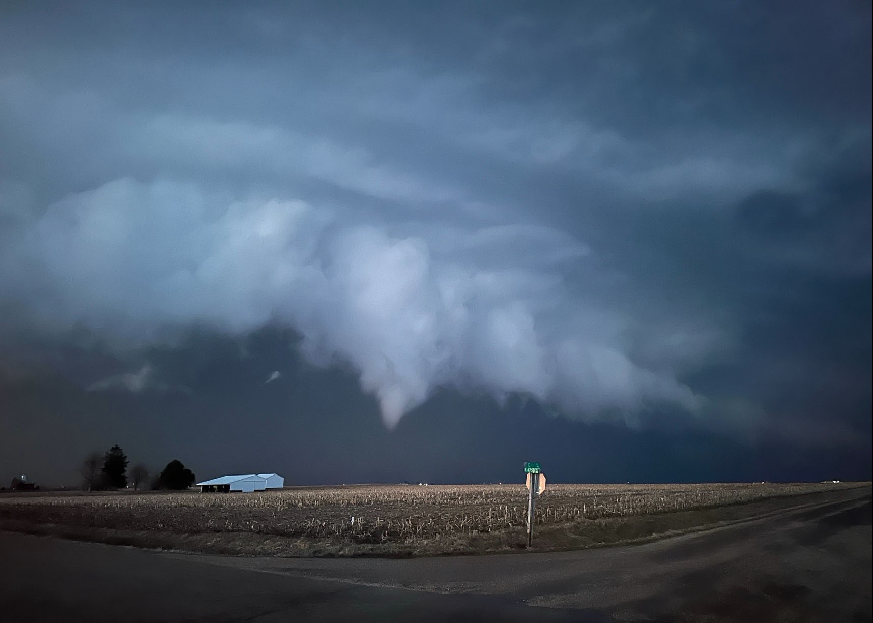 |
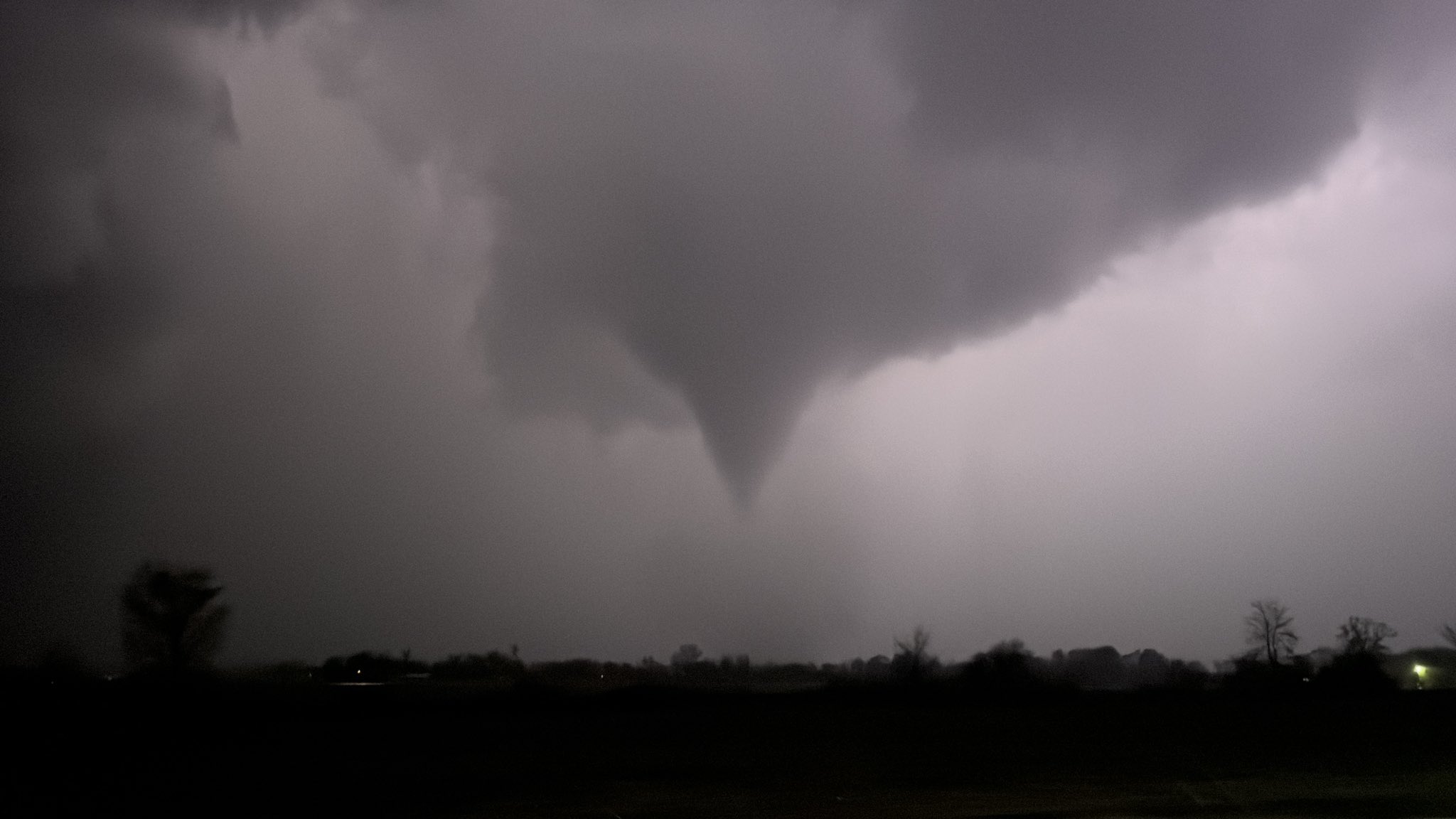
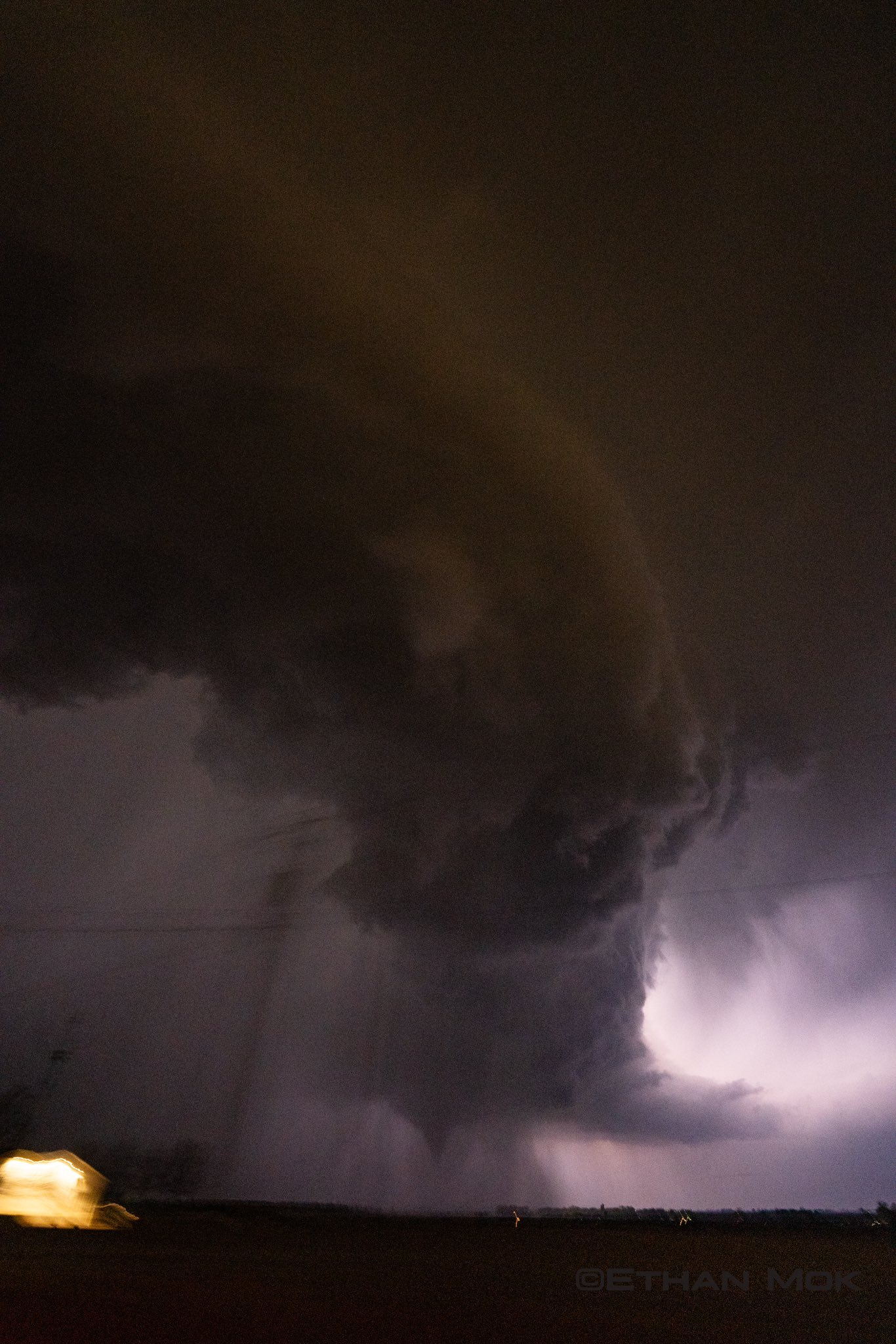
| Tornado south of Hinckley, IL. Photo courtesy of Alex Resel. | Tornado south of Hinckley, IL. Photo courtesy of Ethan Mok. | Funnel cloud east of Sublette, IL. Photo courtesy of Matthew Porcelli. |
 |
 |
 |
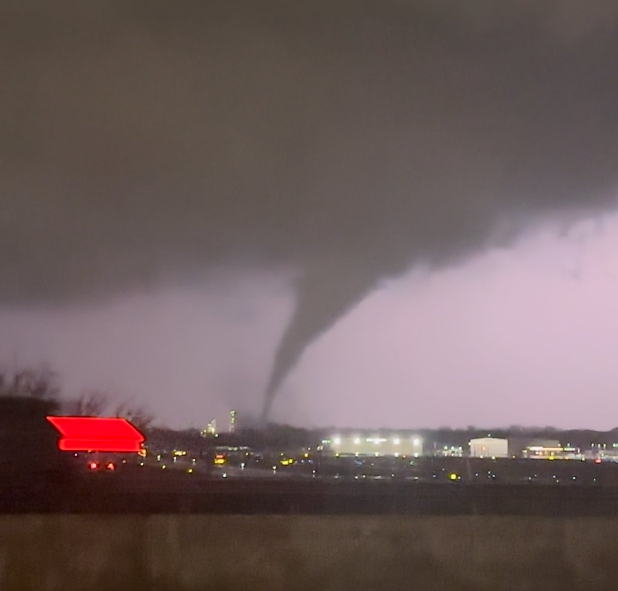
| The Gary, IN tornado. Photo courtesy of Norman Smith. | The Gary, IN tornado. Photo courtesy of Twitter/X user @SpaceSim2. | Tornado damage in Gary, IN. Photo courtesy of Paul Goddard. |
 |
 |
 |
| Hail in Hegewisch, Chicago. Photo courtesy of Eri Marie Soria. | Hail in Plainfield, IL. Photo taken by NWS Chicago meteorologist Jake Petr. | Hail in Lockport, IL. Photo taken by NWS Chicago meteorologist Kevin Doom. |
 |
 |
 |
| Tornado damage south of Hinckley, IL. Photo from NWS damage survey. | Tornado damage at Waubonsee Community College in Sugar Grove, IL. Photo from NWS damage survey. | Tornado damage northwest of North Aurora, IL. Photo from NWS damage survey. |
 |
 |
 |
| Tornado damage in Geneva, IL. Photo from NWS damage survey. | Tornado damage in Hoffman Estates, IL. Photo from NWS damage survey. | Tornado damage in Mundelein, IL. Photo from NWS damage survey. |
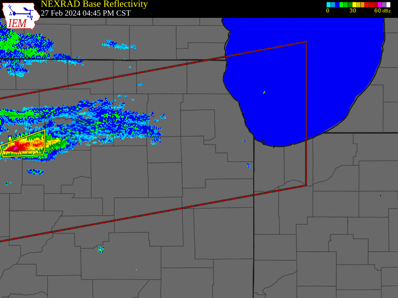
Radar
|
Radar loop courtesy of the Iowa Environmental Mesonet |
Meteorology and Environment
|
|
 |
|
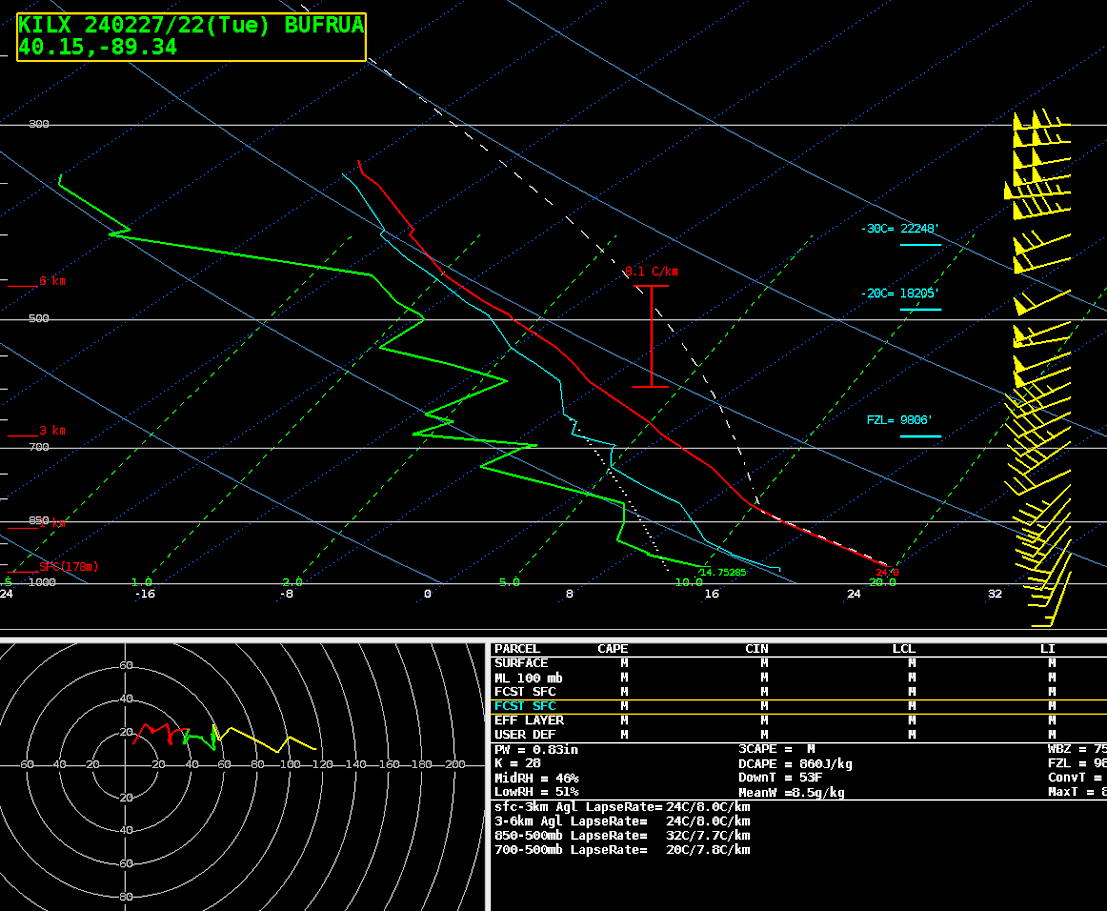
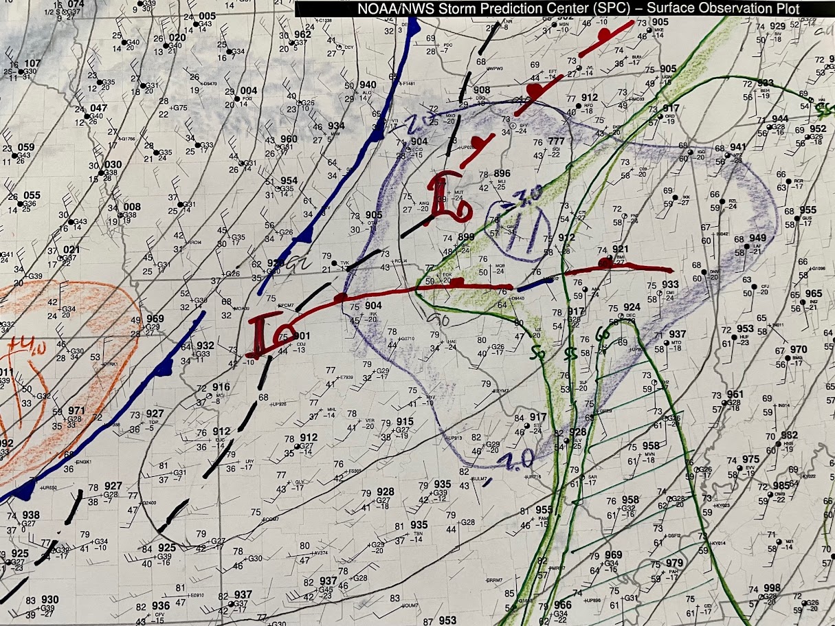
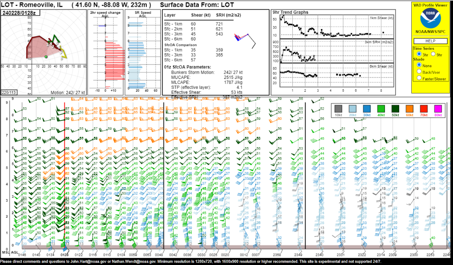
| Hand-analyzed surface map at 3 PM CST. Even though computers can do this automatically, many meteorologists still like to analyze surface charts manually as it helps us focus and find subtle boundaries and features important to severe weather. | Special vertical sounding from Lincoln, Illinois from 4 PM CST. Surface fields have been adjusted based on nearby observations. This plot shows significant potential energy in the upper levels of the atmosphere, along with very strong wind shear, all conducive for severe thunderstorms capable of producing very large hail. | A time series of how winds changed with height as sampled by the KLOT radar. Wind shear in the low levels increased rapidly between 5 and 8 PM CST, creating an environment that was increasingly favorable for tornado development. |
 |
 |
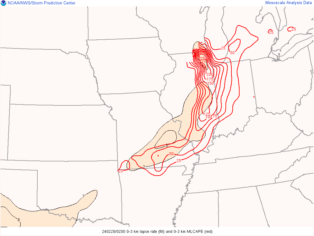 |
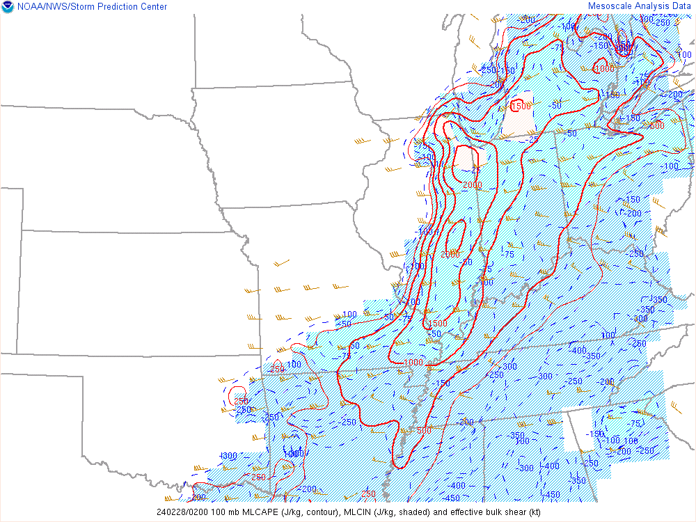
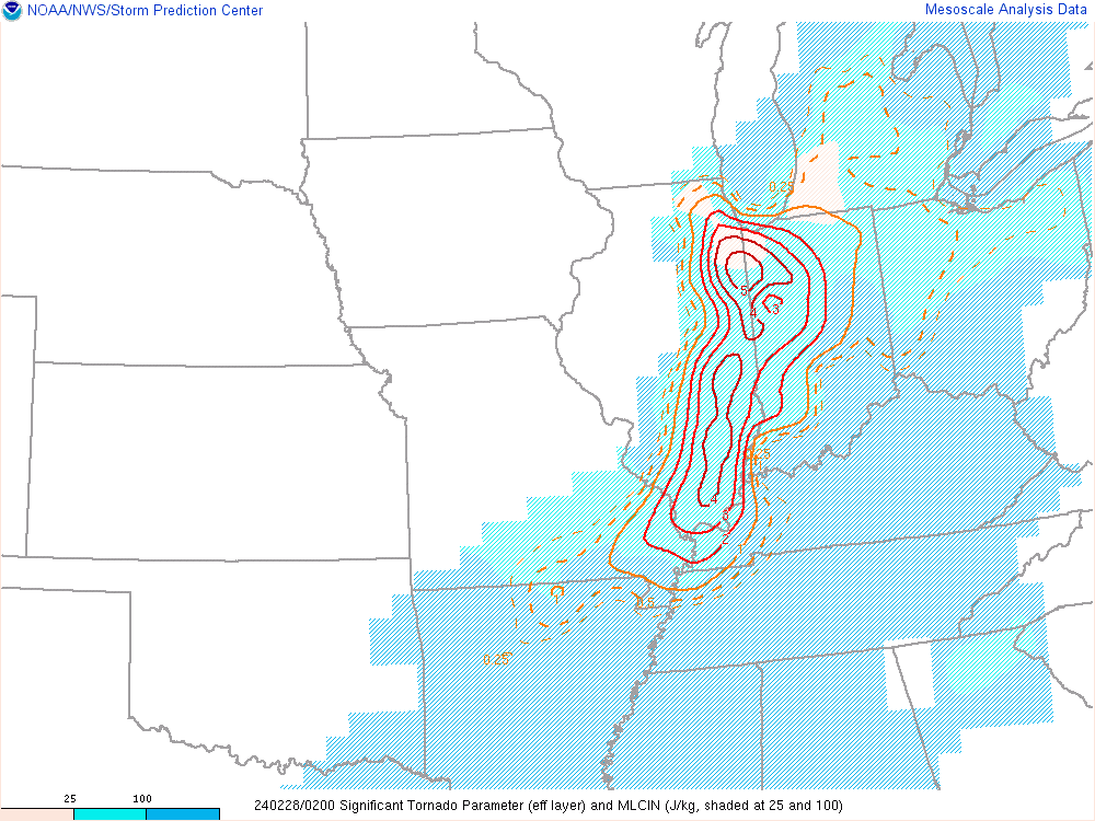
| SPC mesoanalysis image of effective bulk shear (change of wind direction and speed with height) and mixed-layer CAPE (potential energy for storms). The values in northern Illinois and northwest Indiana are all highly conducive for rotating, severe thunderstorms. | SPC mesoanalysis image of the "Effective Significant Tornado Parameter". Values of 2 to 5 are very high for this area and show an environment supportive of tornadoes. One factor that likely limited the intensity of tornadoes was a bit of "convective inhibition" (shading), which limits a thunderstorm's ability to draw in unstable air at the ground -- a key factor in tornado development. | SPC mesoanalysis image of low-level lapse rates (change of temperature) and energy potential in the low-levels. Higher values of each generally signify a greater potential for intense thunderstorms and tornadoes. |
 |
Media use of NWS Web News Stories is encouraged! Please acknowledge the NWS as the source of any news information accessed from this site. Additional recaps can be found on the NWS Chicago Past Events Page |
|


.png)
.png)
.png)
.png)