Record setting heat is expected over the next several days from the Intermountain West through the northern Plains. Furthermore, fire weather concerns increase with dry and breezy conditions. Meanwhile, heavy rainfall and severe thunderstorm threats for the Ohio/Tennessee Valleys, central Appalachians and Southeast today. The threat shifts to central Gulf Coast and across central Texas this week. Read More >
 |
Fast Facts
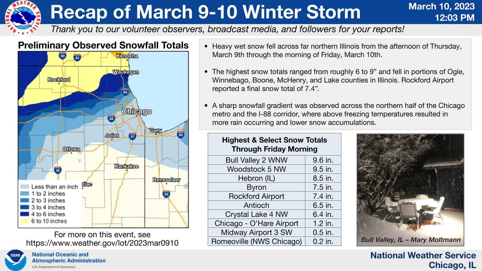
Snow Totals
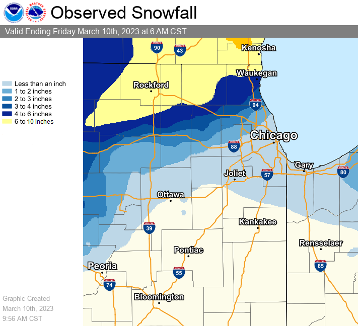 |
| Map of estimated snowfall totals from March 9th through the morning of March 10th. |
Interactive Map of Snowfall Local Storm Reports
PUBLIC INFORMATION STATEMENT...UPDATED
NATIONAL WEATHER SERVICE CHICAGO IL
1120 AM CST FRI MAR 10 2023

...OBSERVED SNOW ACCUMULATIONS FOR 3/9-3/10...

BELOW IS A LISTING OF SNOW REPORTS FROM NORTHERN ILLINOIS AND
NORTHWEST INDIANA FOR THE 3/9/2023 - 3/10/2023 SNOWFALL EVENT
AS RELAYED TO THE NATIONAL WEATHER SERVICE FROM A VARIETY OF
SOURCES.

...SNOWFALL REPORTS...

LOCATION                     AMOUNT    TIME/DATE       PROVIDER

...ILLINOIS...

...BOONE COUNTY...
TIMBERLANE 1 SW              7.8 IN    0700 AM 03/10   COCORAHS
CAPRON                       6.3 IN    0700 AM 03/10   COCORAHS

...COOK COUNTY...
HOFFMAN ESTATES 5 W          3.5 IN    0800 AM 03/10   COCORAHS
HOFFMAN ESTATES              3.1 IN    0700 AM 03/10   COCORAHS
SCHAUMBURG 2 E               2.5 IN    0700 AM 03/10   COCORAHS
ELK GROVE VILLAGE 2 WSW      2.5 IN    0700 AM 03/10   COCORAHS
ARLINGTON HEIGHTS 1 WNW      2.5 IN    0800 AM 03/10   PUBLIC
PALATINE 1 E                 2.3 IN    0735 AM 03/10   COCORAHS
ELK GROVE VILLAGE 1 ESE      2.2 IN    0700 AM 03/10   COCORAHS
MOUNT PROSPECT               2.1 IN    0730 AM 03/10   COCORAHS
PALATINE 1 NNE               2.0 IN    0700 AM 03/10   COCORAHS
OHARE AIRPORT                1.2 IN    0555 AM 03/10   OFFICIAL NWS OBS
HARWOOD HEIGHTS              1.1 IN    0700 AM 03/10   COCORAHS
FRANKLIN PARK                0.8 IN    0800 AM 03/10   COCORAHS
CHICAGO - WEST RIDGE         0.6 IN    0700 AM 03/10   COCORAHS
MIDWAY AIRPORT 3 SW          0.5 IN    0600 AM 03/10   CO-OP OBSERVER
OAK PARK 1 NNE               0.4 IN    0625 AM 03/10   COCORAHS
EVANSTON 1 E                 0.4 IN    0800 AM 03/10   COCORAHS
OAK LAWN 2 WNW               0.4 IN    0800 AM 03/10   COCORAHS
LA GRANGE PARK 1 SSW         0.3 IN    0700 AM 03/10   COCORAHS
CHICAGO RIDGE                0.3 IN    0700 AM 03/10   COCORAHS
OAK FOREST 1 NNW             0.2 IN    0700 AM 03/10   COCORAHS
PARK FOREST 1 NNE            0.1 IN    0700 AM 03/10   COCORAHS
PARK FOREST                   TRACE    0500 AM 03/10   COOP
OAK LAWN                      TRACE    0615 AM 03/10   COCORAHS
LANSING                       TRACE    0700 AM 03/10   COOP
PALOS PARK 2 WSW              TRACE    0700 AM 03/10   COCORAHS
PARK FOREST 1 WNW             TRACE    0730 AM 03/10   COCORAHS
BRIDGEVIEW 1 WNW              TRACE    0730 AM 03/10   COCORAHS

...DE KALB COUNTY...
GENOA                        4.2 IN    0600 AM 03/10   CO-OP OBSERVER
MALTA 3 ESE                  3.3 IN    0700 AM 03/10   COCORAHS
DEKALB                       3.0 IN    0700 AM 03/10   COCORAHS
CORTLAND                     2.4 IN    0530 AM 03/10   COCORAHS

...DUPAGE COUNTY...
GLEN ELLYN 1 W               2.0 IN    0700 AM 03/10   COCORAHS
WEST CHICAGO 4 NNE           2.0 IN    0700 AM 03/10   COCORAHS
WEST CHICAGO 4 SE            1.3 IN    0658 AM 03/10   COCORAHS
GLEN ELLYN 1 SW              1.1 IN    0740 AM 03/10   COCORAHS
WINFIELD 1 ENE               0.9 IN    0800 AM 03/10   COCORAHS
VILLA PARK                   0.8 IN    0700 AM 03/10   COCORAHS
DARIEN 2 SE                  0.4 IN    0700 AM 03/10   COCORAHS
ELMHURST 2 SE                0.4 IN    0700 AM 03/10   COCORAHS
LOMBARD                      0.3 IN    0700 AM 03/10   COCORAHS
CLARENDON HILLS              0.2 IN    0700 AM 03/10   UCOOP
AURORA 4 ESE                 0.2 IN    0700 AM 03/10   COCORAHS
MORTON ARBORETUM              TRACE    0700 AM 03/10   COOP
BOLINGBROOK 3 NE              TRACE    0700 AM 03/10   COCORAHS

...KANE COUNTY...
VIRGIL                       4.5 IN    0800 AM 03/10   PUBLIC
LILY LAKE 1 NE               3.9 IN    0700 AM 03/10   COCORAHS
CAMPTON HILLS 3 NNE          3.5 IN    0700 AM 03/10   COCORAHS
MAPLE PARK                   3.0 IN    0530 AM 03/10   COCORAHS
ELGIN 3 W                    3.0 IN    0700 AM 03/10   COCORAHS
ST. CHARLES 1 ENE            2.5 IN    0800 AM 03/10   COCORAHS
SLEEPY HOLLOW 1 W            2.4 IN    0700 AM 03/10   COCORAHS
GENEVA 2 WNW                 2.2 IN    0700 AM 03/10   COCORAHS
ELGIN                        2.0 IN    0700 AM 03/10   COOP
GENEVA 1 SSW                 2.0 IN    0730 AM 03/10   COCORAHS
GENEVA 4 WSW                 1.5 IN    0500 AM 03/10   COCORAHS
BATAVIA 1 NW                 1.5 IN    0700 AM 03/10   COCORAHS
GENEVA                       1.5 IN    0800 AM 03/10   COCORAHS
GENEVA 1 SSW                 1.5 IN    0800 AM 03/10   COCORAHS
KANEVILLE 4 WNW              1.2 IN    0600 AM 03/10   COCORAHS
BATAVIA                      1.1 IN    0600 AM 03/10   UCOOP
NORTH AURORA 1 ENE           1.0 IN    0600 AM 03/10   COCORAHS
AURORA 2 W                   0.8 IN    0700 AM 03/10   COCORAHS
BATAVIA                      0.6 IN    0735 AM 03/10   COCORAHS
BATAVIA                      0.5 IN    0700 AM 03/10   COCORAHS

...KENDALL COUNTY...
PLAINFIELD 4 SW               TRACE    0700 AM 03/10   COCORAHS
OSWEGO 4 SE                   TRACE    0700 AM 03/10   COCORAHS
OSWEGO                        TRACE    0700 AM 03/10   COCORAHS

...LA SALLE COUNTY...
EARLVILLE 3 S                1.0 IN    0600 AM 03/10   COOP
PERU 1 NNE                   0.3 IN    0700 AM 03/10   COCORAHS
OTTAWA                        TRACE    0449 AM 03/10   COCORAHS
LA SALLE                      TRACE    0700 AM 03/10   COCORAHS
OTTAWA - BUFFALO ROCK SP      TRACE    0730 AM 03/10   COOP

...LAKE COUNTY...
ANTIOCH                      6.5 IN    0800 AM 03/10   PUBLIC
WADSWORTH 1 S                6.3 IN    0700 AM 03/10   COCORAHS
LAKE ZURICH                  6.0 IN    0700 AM 03/10   CO-OP OBSERVER
MUNDELEIN                    6.0 IN    0700 AM 03/10   CO-OP OBSERVER
LAKE VILLA 1 SSW             5.5 IN    0630 AM 03/10   COCORAHS
ANTIOCH                      5.0 IN    0517 AM 03/10   BROADCAST MEDIA
MUNDELEIN 1 NNE              5.0 IN    0800 AM 03/10   COCORAHS
TOWER LAKES 1 NNE            4.6 IN    0700 AM 03/10   TRAINED SPOTTER
LAKE ZURICH 1 W              3.8 IN    0700 AM 03/10   COCORAHS
BUFFALO GROVE 2 N            3.6 IN    0700 AM 03/10   COCORAHS
LONG LAKE                    3.5 IN    0713 AM 03/10   COCORAHS
BANNOCKBURN                  3.0 IN    0700 AM 03/10   COCORAHS
HIGHWOOD                     3.0 IN    0700 AM 03/10   COCORAHS
RIVERWOODS 1 NE              2.9 IN    0700 AM 03/10   COCORAHS

...LEE COUNTY...
STERLING 4 NE                4.0 IN    0800 AM 03/10   COCORAHS
DIXON                        3.5 IN    0700 AM 03/10   COOP
ASHTON                       2.0 IN    0700 AM 03/10   COCORAHS
STEWARD 3 S                  1.2 IN    0700 AM 03/10   COOP

...MCHENRY COUNTY...
BULL VALLEY 2 WNW            9.6 IN    0640 AM 03/10   COCORAHS
WOODSTOCK 5 NW               9.5 IN    0700 AM 03/10   CO-OP OBSERVER
HARVARD 3 SSE                9.1 IN    0700 AM 03/10   COCORAHS
HEBRON                       8.5 IN    0700 AM 03/10   CO-OP OBSERVER
HARVARD                      8.0 IN    0700 AM 03/10   CO-OP OBSERVER
CRYSTAL LAKE 1 WSW           7.8 IN    0700 AM 03/10   COCORAHS
UNION 3 NE                   7.0 IN    0745 AM 03/10   COCORAHS
CRYSTAL LAKE 4 NW            6.4 IN    0700 AM 03/10   COOP
MARENGO                      6.4 IN    0700 AM 03/10   COCORAHS
LAKEWOOD                     5.5 IN    0600 AM 03/10   PUBLIC
LAKE IN THE HILLS 1 SSE      5.5 IN    0655 AM 03/10   COCORAHS
SPRING GROVE 1 ESE           5.1 IN    0700 AM 03/10   COCORAHS
ALGONQUIN                    5.0 IN    0600 AM 03/10   COCORAHS
MCCULLOM LAKE 1 S            5.0 IN    0720 AM 03/10   PUBLIC
MCHENRY 1 ENE                4.5 IN    0900 AM 03/10   COCORAHS
MCHENRY LOCK AND DAM         4.0 IN    0800 AM 03/10   COOP
TROUT VALLEY                 3.0 IN    0605 AM 03/10   COCORAHS

...OGLE COUNTY...
BYRON                        7.5 IN    0600 AM 03/10   PUBLIC

...WILL COUNTY...
CRETE 3 E                    0.4 IN    0700 AM 03/10   COCORAHS
MONEE 5 SE                   0.3 IN    0800 AM 03/10   COCORAHS
ROMEOVILLE - NWS CHICAGO     0.2 IN    0600 AM 03/10   OFFICAL NWS OBS
MANHATTAN 5 ENE              0.2 IN    0800 AM 03/10   COOP
MOKENA 2 WSW                 0.1 IN    0700 AM 03/10   COCORAHS
NAPERVILLE 5 SSW              TRACE    0700 AM 03/10   COCORAHS
NEW LENOX 1 SSE               TRACE    0700 AM 03/10   COCORAHS
PLAINFIELD 2 SSE              TRACE    0700 AM 03/10   COCORAHS
MOKENA 1 W                    TRACE    0700 AM 03/10   COCORAHS
HOMER GLEN 1 NNE              TRACE    0700 AM 03/10   COCORAHS
NEW LENOX 1 SE                TRACE    0800 AM 03/10   COCORAHS

...WINNEBAGO COUNTY...
ROCKFORD 3 SE                8.5 IN    0725 AM 03/10   PUBLIC
LOVES PARK 2 SSE             7.9 IN    0700 AM 03/10   COCORAHS
ROCKFORD AIRPORT             7.4 IN    1200 PM 03/10   OFFICIAL NWS OBS
ROCKFORD 3 WSW               7.0 IN    0700 AM 03/10   COCORAHS
ROCKFORD 4 WNW               6.9 IN    0700 AM 03/10   COCORAHS
WINNEBAGO 4 ENE              6.4 IN    0715 AM 03/10   BROADCAST MEDIA

...INDIANA...

...LAKE COUNTY...
GARY 5 ENE                   0.4 IN    0700 AM 03/10   COCORAHS
DYER                         0.3 IN    0700 AM 03/10   COCORAHS
ST. JOHN                     0.1 IN    0600 AM 03/10   COCORAHS
ST. JOHN 3 SSE                TRACE    0700 AM 03/10   COCORAHS
HOBART 2 SE                   TRACE    0700 AM 03/10   COCORAHS

...PORTER COUNTY...
VALPARAISO 1 N               1.2 IN    0700 AM 03/10   COCORAHS
VALPARAISO 3 NNE             1.0 IN    0700 AM 03/10   COCORAHS
VALPARAISO 4 SW              0.5 IN    0600 AM 03/10   COCORAHS
CHESTERTON 2 E               0.5 IN    0630 AM 03/10   COCORAHS
PORTER                       0.5 IN    0700 AM 03/10   COCORAHS
WANATAH                      0.4 IN    0700 AM 03/10   COOP
BOONE GROVE 4 NNE            0.3 IN    0615 AM 03/10   COCORAHS
OGDEN DUNES                  0.2 IN    0505 AM 03/10   COCORAHS
CHESTERTON 4 ESE             0.1 IN    0700 AM 03/10   COCORAHS

OBSERVATIONS ARE COLLECTED FROM A VARIETY OF SOURCES WITH VARYING
EQUIPMENT AND EXPOSURES. WE THANK ALL VOLUNTEER WEATHER OBSERVERS
FOR THEIR DEDICATION. NOT ALL DATA LISTED ARE CONSIDERED OFFICIAL.
Photos and Additional Information
Photos
|
|
|
|
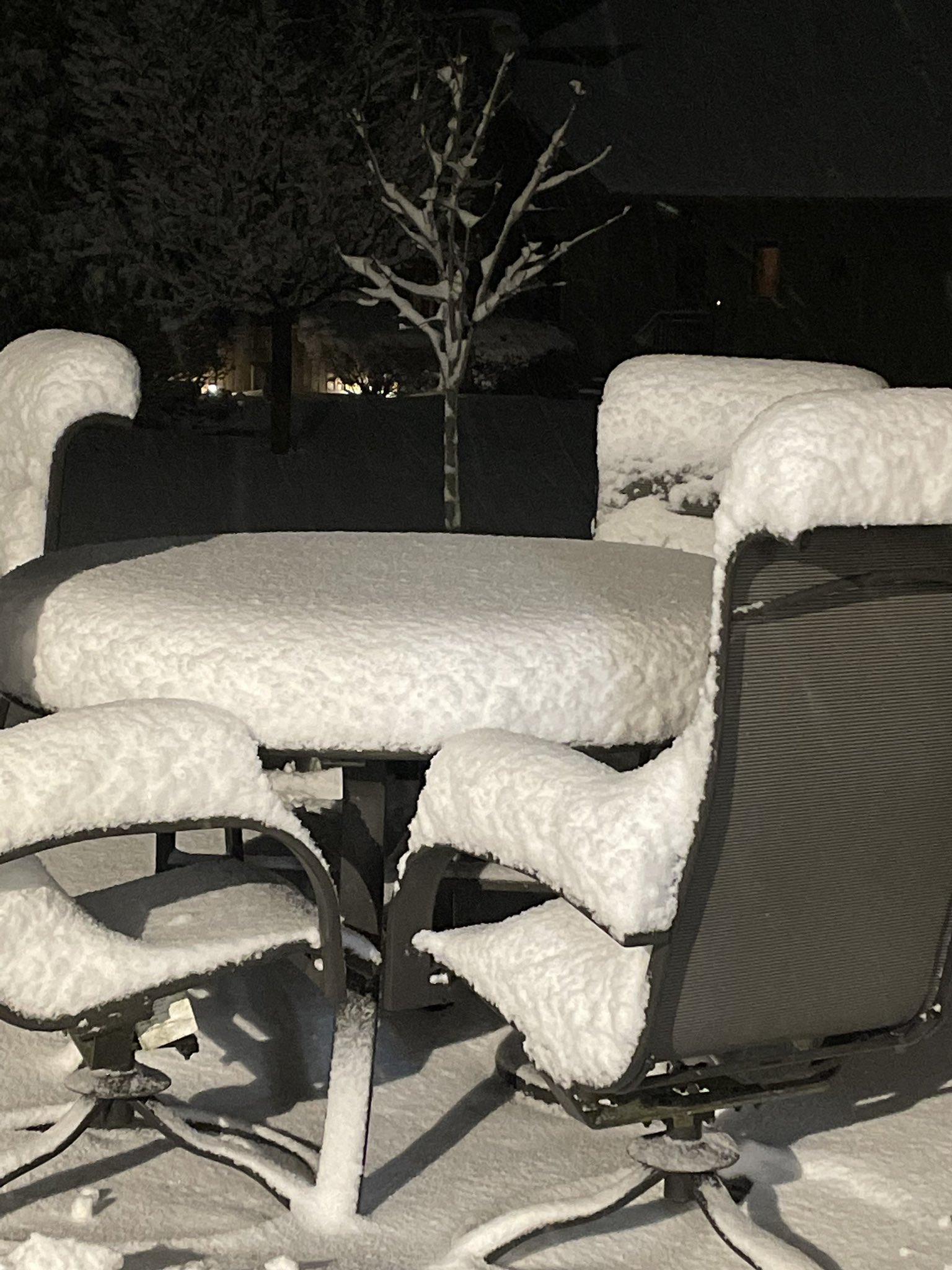
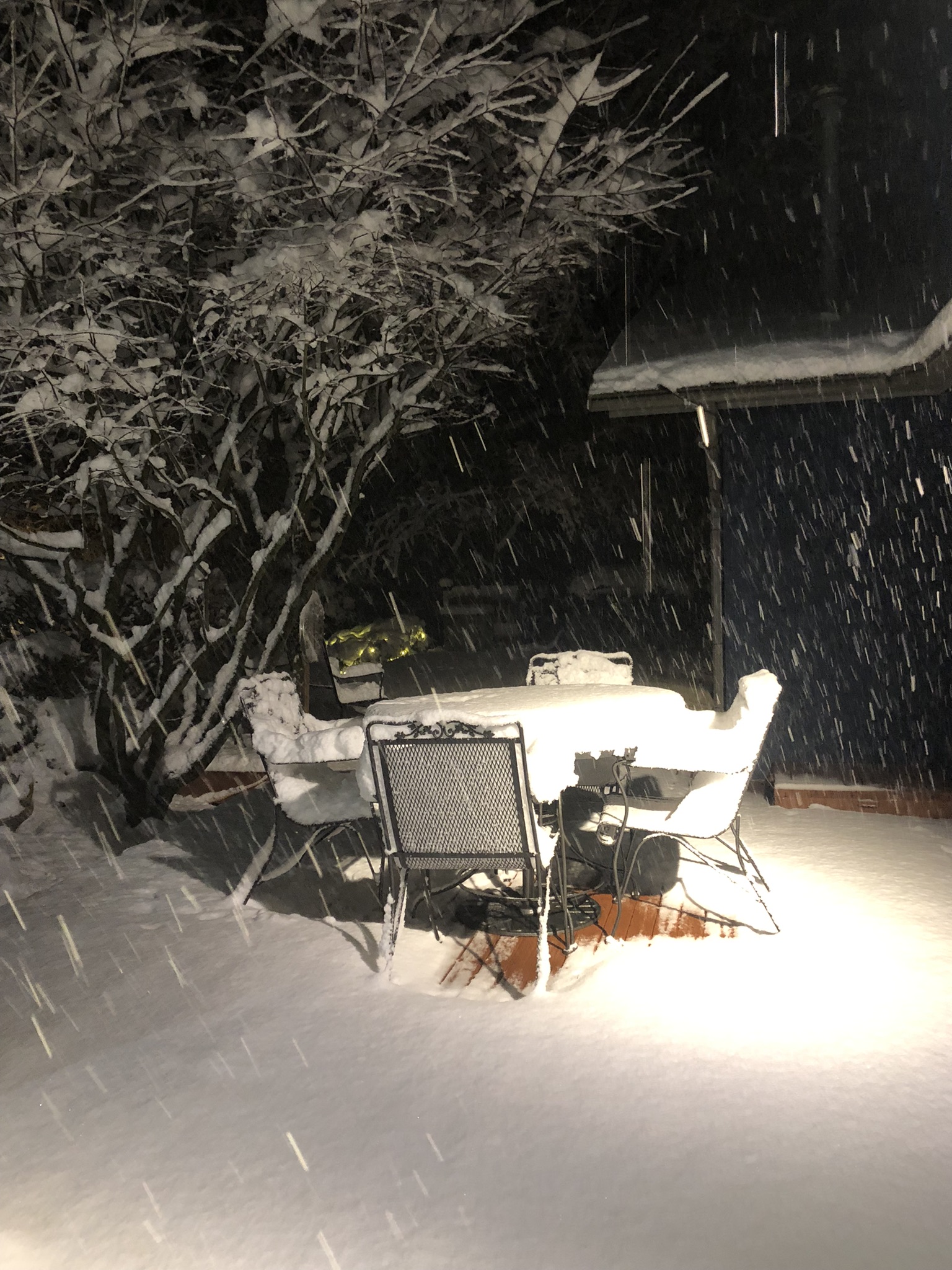
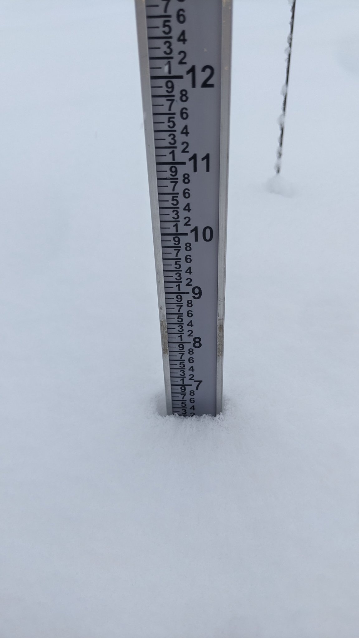
| Snow in Byron, IL. Photo courtesy of Max Connell. | Snow in Bull Valley, IL. Photo courtesy of Mary Moltmann. | Snow near Winnebago, IL. Photo courtesy of Joey Marino (WTVO/WQRF). |
Links
 |
Media use of NWS Web News Stories is encouraged! Additional recaps can be found on the NWS Chicago Past Events Page. |
|