Record setting heat is expected over the next several days from the Intermountain West through the northern Plains. Furthermore, fire weather concerns increase with dry and breezy conditions. Meanwhile, heavy rainfall and severe thunderstorm threats for the Ohio/Tennessee Valleys, central Appalachians and Southeast today. The threat shifts to central Gulf Coast and across central Texas this week. Read More >
|
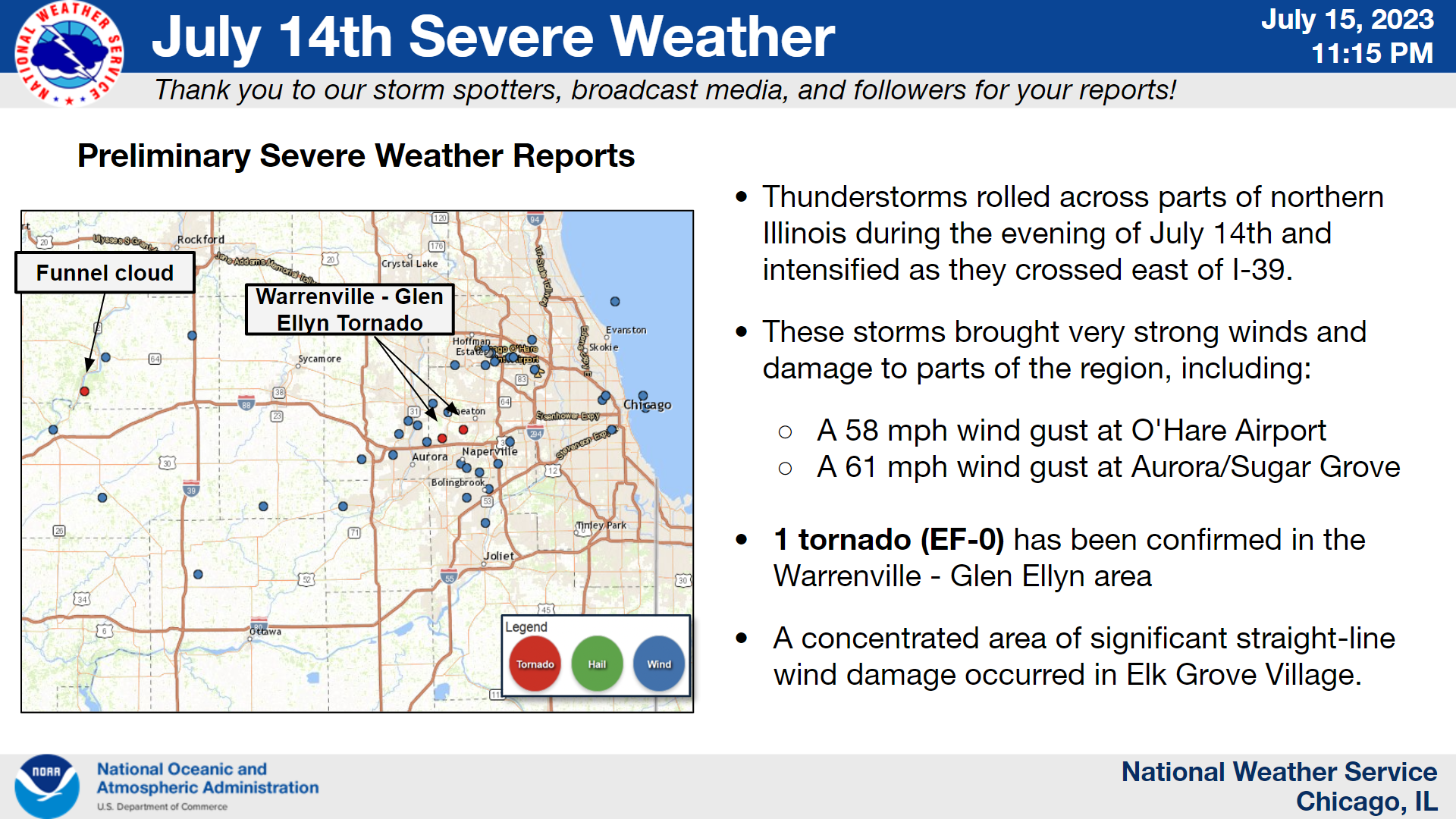
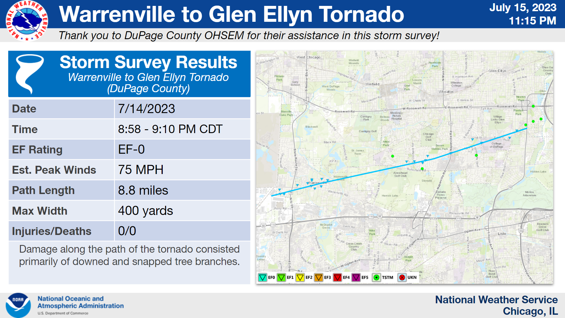
Overview of July 14, 2023 Severe Weather |
Fast Facts
Tornado Information
Details on the Warrenville - Glen Ellyn Tornado and Elk Grove Village straight-line wind damage can be found in this Public Information Statement.
Warrenville to Glen Ellyn EF-0:
|
(click on image to enlarge) |
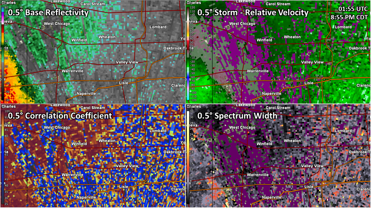
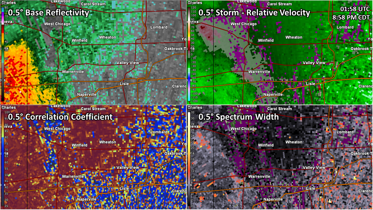
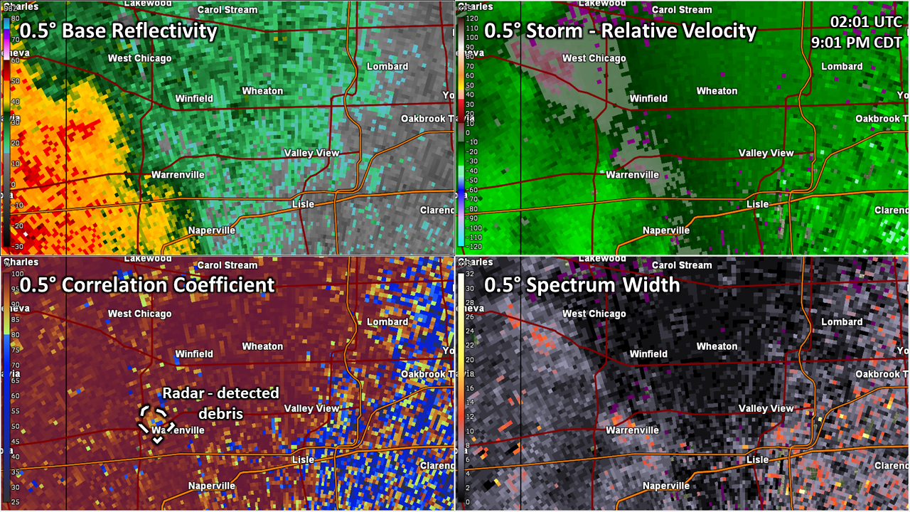
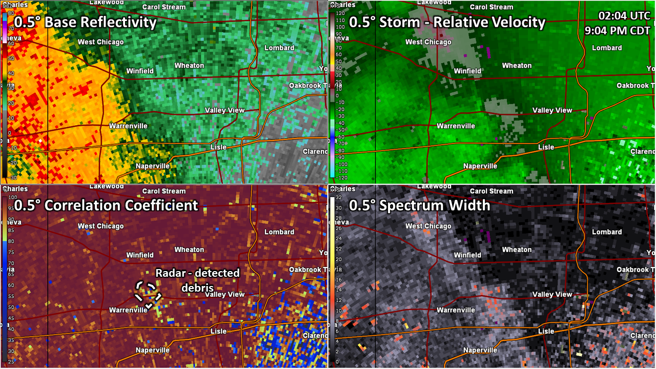
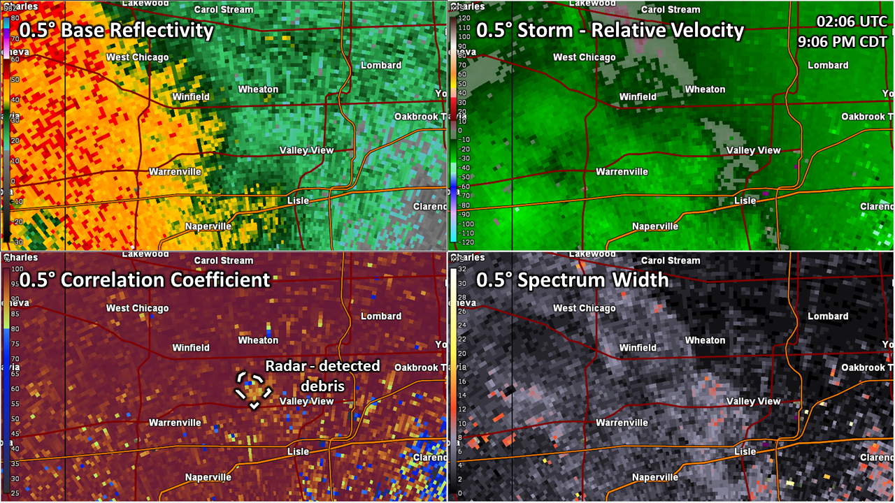
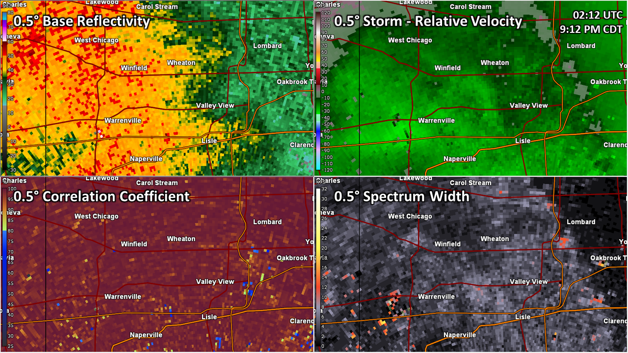
This is a 17 minute radar loop showing our radar detecting lofted debris in the Warrenville/Wheaton area.


The Enhanced Fujita (EF) Scale classifies tornadoes into the following categories:
| EF0 Weak 65-85 mph |
EF1 Moderate 86-110 mph |
EF2 Significant 111-135 mph |
EF3 Severe 136-165 mph |
EF4 Extreme 166-200 mph |
EF5 Catastrophic 200+ mph |
 |
|||||
When a tornado is known to have occurred but does not cause damage to any qualified damage indicators, or if the only damage is located in an area that is inaccessible to NWS storm survey personnel, then a tornado may be assigned the EF-Unknown (EF-U) rating.
Storm Reports
|
Preliminary storm reports from 7/14/2023 |
Preliminary Local Storm Report...Summary
National Weather Service Chicago IL
642 PM CDT Sun Jul 16 2023
..TIME... ...EVENT... ...CITY LOCATION... ...LAT.LON...
..DATE... ....MAG.... ..COUNTY LOCATION..ST.. ...SOURCE....
..REMARKS..
0700 PM Tstm Wnd Dmg Dixon 41.84N 89.48W
07/14/2023 Lee IL Public
Two large tree limbs blown down and a porch
roof collapsed. Relayed through social
media.
0707 PM Funnel Cloud 2 NNW Lost Nation 41.93N 89.38W
07/14/2023 Ogle IL Public
Video shared on social media showing a
well-defined funnel roughly 2/3rds the way
down to the ground. Location based on video
time stamp and co-located to radar-indicated
rotation.
0725 PM Tstm Wnd Dmg 1 E Oregon 42.01N 89.31W
07/14/2023 Ogle IL Emergency Mngr
Powerlines down with one power pole snapped.
Time estimated by radar.
0735 PM Tstm Wnd Dmg 2 S Amboy 41.68N 89.32W
07/14/2023 Lee IL Law Enforcement
Large tree down on the 700 block of Dry
Gulch road. Was blocking three quarters of
the roadway. Time estimated based on radar.
0745 PM Tstm Wnd Dmg Lindenwood 42.06N 89.03W
07/14/2023 Ogle IL Public
Trees downed.
0754 PM Tstm Wnd Dmg 1 NE Triumph 41.50N 89.01W
07/14/2023 La Salle IL Law Enforcement
Reports of a large tree downed onto a
property north of Triumph.
0817 PM Tstm Wnd Gst 3 N Leland 41.66N 88.80W
07/14/2023 M55 MPH De Kalb IL Public
Personal weather station measured a gust to
55 mph.
0839 PM Tstm Wnd Gst Plano 41.66N 88.54W
07/14/2023 M64 MPH Kendall IL Public
Personal weather station measured a wind
gust to 64 mph.
0842 PM Tstm Wnd Gst Sugar Grove Airport 41.77N 88.48W
07/14/2023 M61 MPH Kane IL ASOS
Measured gust to 61 mph at ARR ASOS.
0845 PM Tstm Wnd Dmg 3 SW North Aurora 41.78N 88.38W
07/14/2023 Kane IL Public
Corrects time of previous tstm wnd dmg
report from 3 SW North Aurora. Large tree
landed on car in west side of Aurora off
Orchard Road.
0852 PM Tstm Wnd Gst 2 NW North Aurora 41.83N 88.36W
07/14/2023 M69 MPH Kane IL Mesonet
Measured at KILBATAV3.
0856 PM Tstm Wnd Dmg 1 WNW Batavia 41.86N 88.33W
07/14/2023 Kane IL Emergency Mngr
Numerous 6 inch diameter branches and limbs
down all over the area, particularly between
McKee and Fabyan Parkway, east towards Route
31.
0857 PM Tstm Wnd Dmg 1 ENE Batavia 41.85N 88.30W
07/14/2023 Kane IL Emergency Mngr
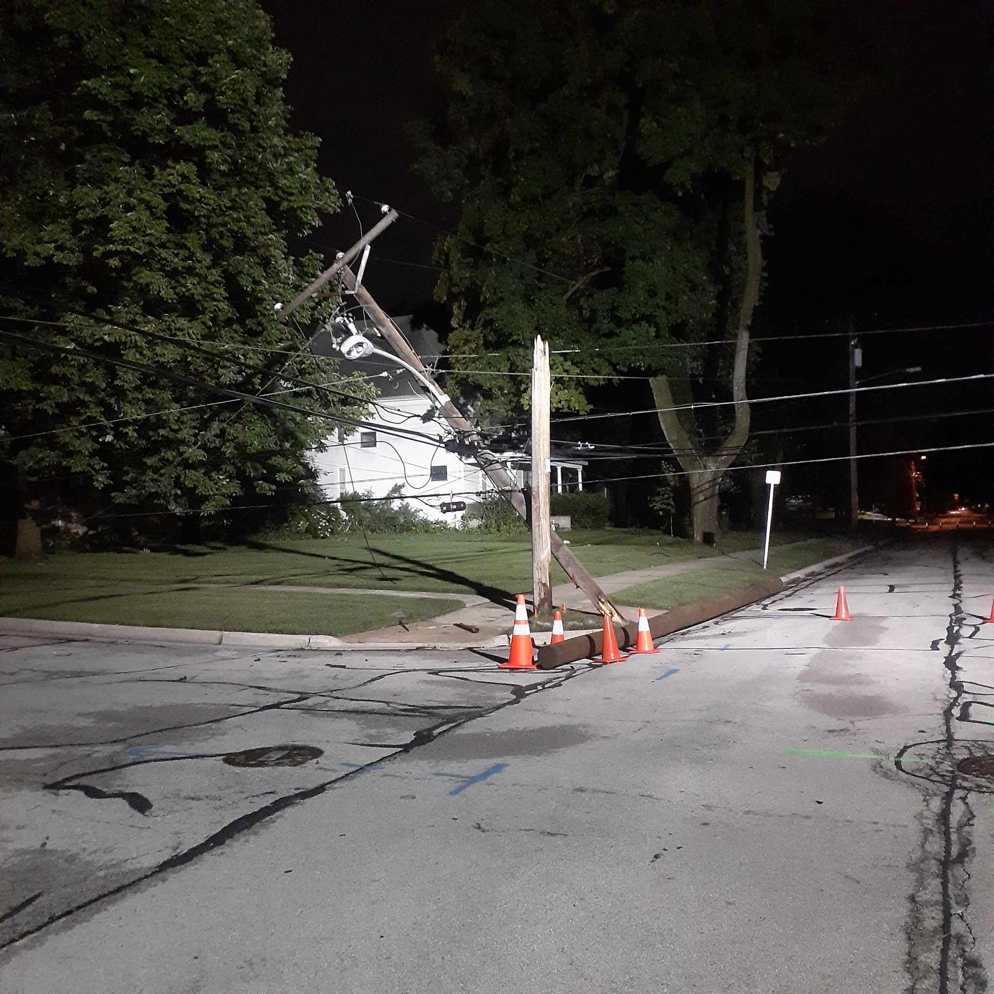
Fallen one foot diameter tree limb took out
three power poles on N Van Buren and Spring
Street.
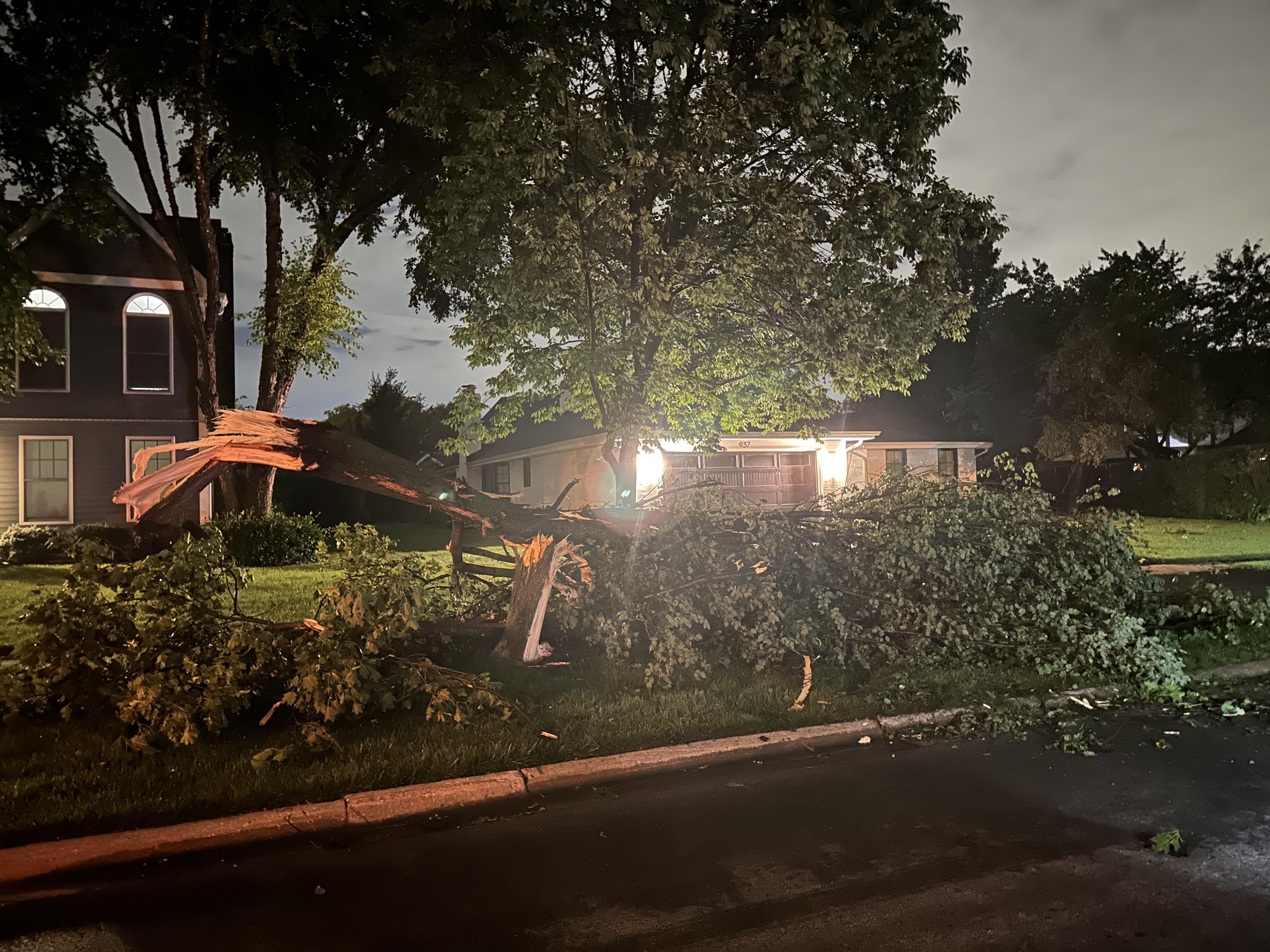
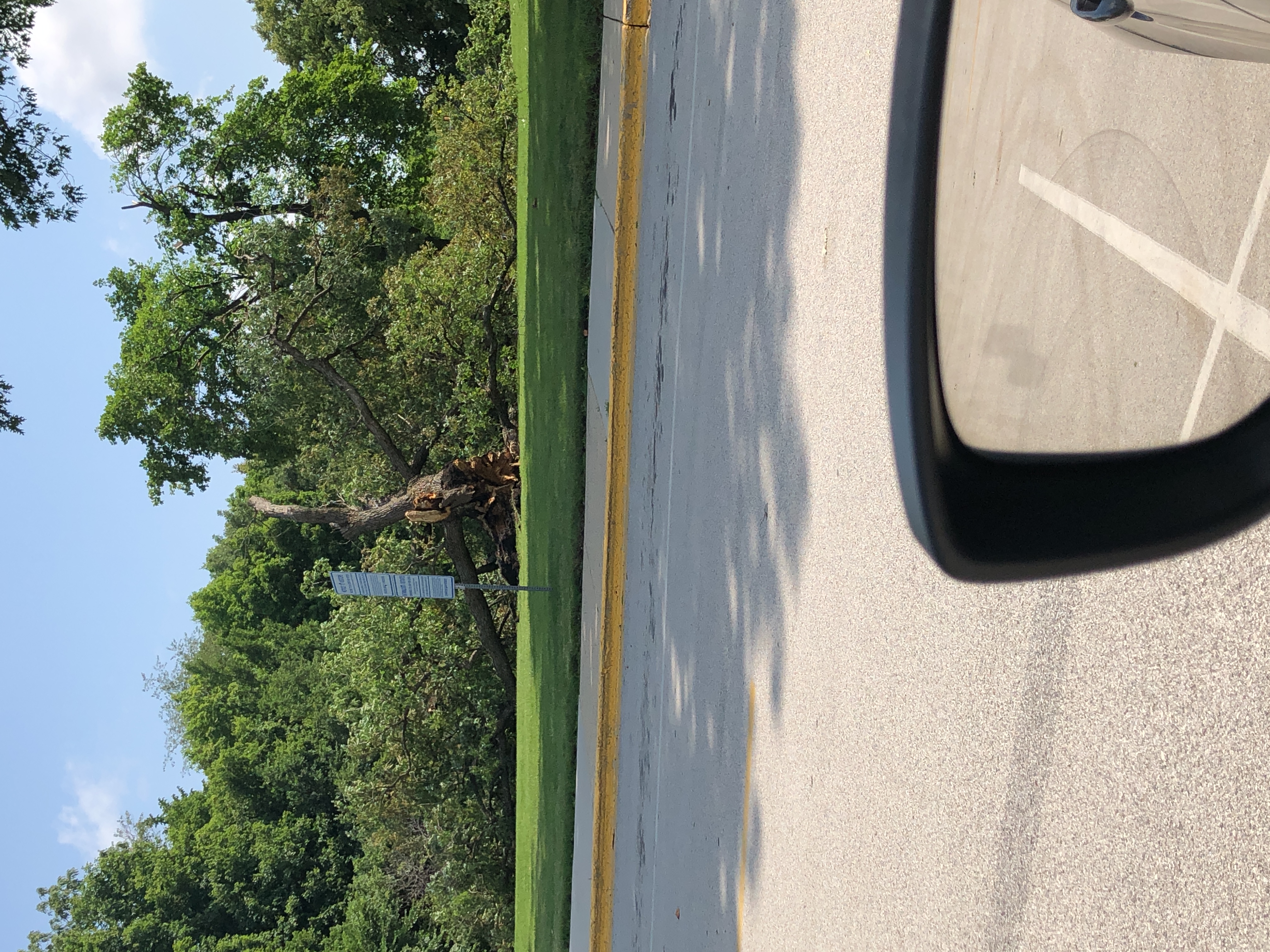
0858 PM Tornado 2 W Warrenville 41.82N 88.22W
07/14/2023 DuPage IL NWS Storm Survey
An NWS damage survey determined an EF-0
tornado with estimated peak winds of 75 mph,
path width of 400 yards, and path length of
8.8 miles started near Fermilab and lifted
in Glen Ellyn near the College of DuPage.
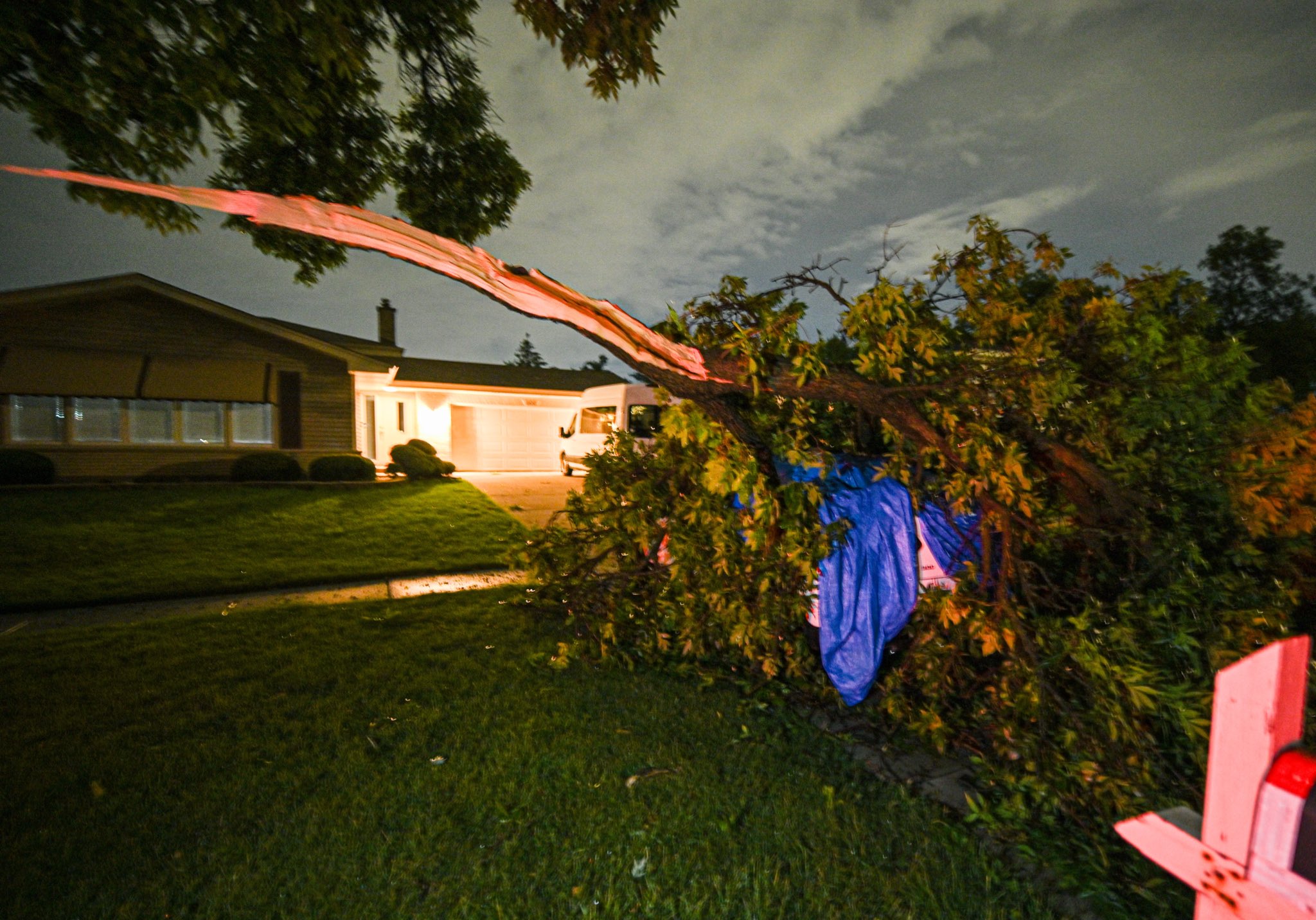
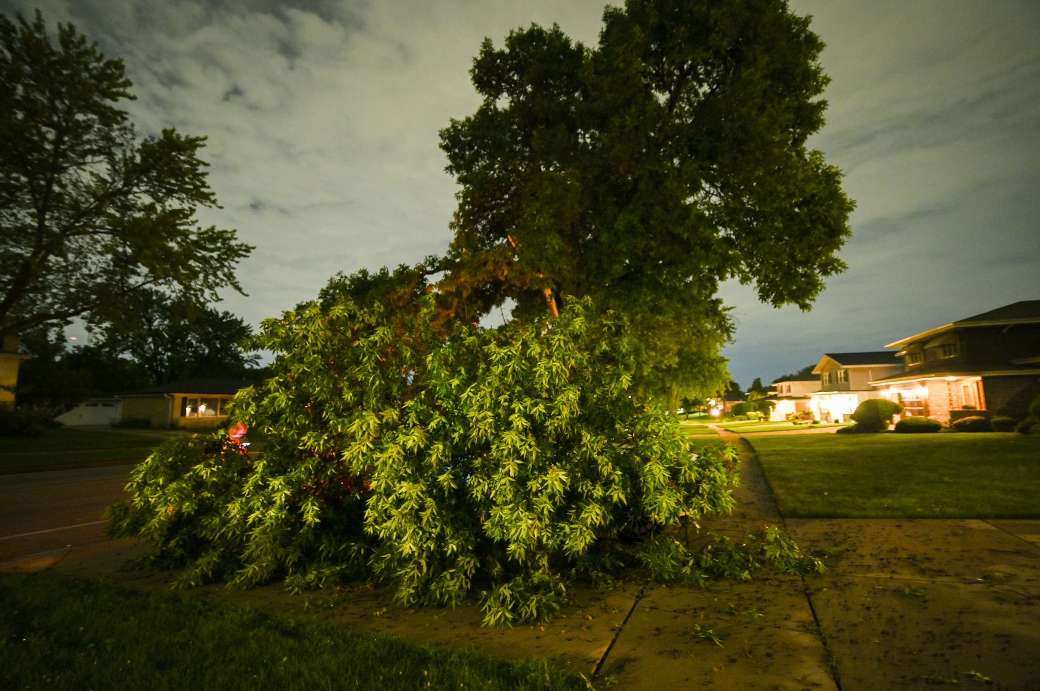
Damage along the path consisted mostly of
downed trees and tree branches.
0900 PM Tstm Wnd Gst 3 E North Aurora 41.81N 88.27W
07/14/2023 M87 MPH Kane IL Public
Personal weather station measured a wind
gust to 87 mph.
0901 PM Tstm Wnd Dmg 1 SSW Naperville 41.76N 88.16W
07/14/2023 DuPage IL Public
4 inch diameter tree limb downed on West St.
Time estimated.
0901 PM Tstm Wnd Dmg 3 NNW Bolingbrook 41.74N 88.10W
07/14/2023 DuPage IL NWS Employee
6 inch diameter branch down at Wehrli and
Lisson Roads.
0902 PM Tstm Wnd Dmg 2 SSE Naperville 41.75N 88.14W
07/14/2023 DuPage IL NWS Employee
Multiple 3 inch diameter tree limbs downed.
Time estimated from radar.
0903 PM Tstm Wnd Dmg West Chicago 41.88N 88.20W
07/14/2023 DuPage IL Emergency Mngr
EM relayed a photo of a snapped tree branch
at least 12 inches in diameter from a
healthy tree. Time estimated by radar.
0904 PM Tornado 2 NE Warrenville 41.84N 88.15W
07/14/2023 DuPage IL Official NWS Obs
Radar indicated damage.
0905 PM Tstm Wnd Dmg 1 SW Romeoville 41.63N 88.11W
07/14/2023 Will IL Public
12 to 14 foot tall pine tree blown down.
Time estimated from radar.
0906 PM Tstm Wnd Gst DuPage Airport 41.90N 88.25W
07/14/2023 M53 MPH DuPage IL ASOS
Measured gust to 53 mph at DuPage Airport.
0906 PM Tstm Wnd Dmg Woodridge 41.76N 88.04W
07/14/2023 DuPage IL NWS Employee
Numerous limbs and branches down in the
vicinity, some blocking roadways.
0907 PM Tstm Wnd Dmg 1 N NWS Chicago-Romeovi 41.62N 88.08W
07/14/2023 Will IL NWS Employee
Small pine tree uprooted. Time estimated
from radar.
0907 PM Tstm Wnd Dmg Bolingbrook 41.70N 88.07W
07/14/2023 Will IL Public
Numerous 6 inch diameter branches down.
Reported via social media.
0910 PM Tstm Wnd Dmg 1 NE Downers Grove 41.81N 88.00W
07/14/2023 DuPage IL Public
Corrects time of previous tstm wnd dmg
report from 1 NE Downers Grove. Tree
uprooted out of ground near Fairview and
Ogden in Downers Grove.
0911 PM Tstm Wnd Dmg 2 NW Carol Stream 41.93N 88.17W
07/14/2023 DuPage IL Trained Spotter
4 to 6 inch diameter tree branch snapped.
Time estimated from radar.
0918 PM Tstm Wnd Gst 1 NNW Roselle 41.99N 88.08W
07/14/2023 E65 MPH Cook IL Trained Spotter
Estimates 65 to 70 mph wind gusts.
0920 PM Tstm Wnd Dmg Addison 41.93N 88.00W
07/14/2023 DuPage IL Public
Two trees downed in Addison. Time estimated
from radar.
0920 PM Tstm Wnd Dmg Bartlett 41.99N 88.18W
07/14/2023 Cook IL Law Enforcement
Trees and power lines downed in Bartlett.
Time estimated from radar.
0920 PM Tstm Wnd Dmg 1 NNW Roselle 41.99N 88.08W
07/14/2023 Cook IL Trained Spotter
Numerous medium sized tree branches down in
Roselle at corner of May Street and Arthur
Avenue. Power is also out on the west side
of May Street. Relayed via spotter network.
0922 PM Non-Tstm Wnd Dmg 1 SE Schaumburg 42.02N 88.07W
07/14/2023 Cook IL Public
1 foot diameter tree limb through a car
windshield. Picture shared on social media.
0925 PM Tstm Wnd Gst 1 NNW Elk Grove Village 42.01N 88.00W
07/14/2023 E80 MPH Cook IL NWS Storm Survey
An NWS storm survey confirmed that
widespread tree damage across Elk Grove
Village was caused by strong straight-line
winds. Damage was most severe and
concentrated in the vicinity of Elk Grove
High School, where peak winds were estimated
to be about 80 mph.
0925 PM Tstm Wnd Gst 1 N Medinah 42.00N 88.05W
07/14/2023 E70 MPH Cook IL Public
CoCoRAHS observer reported 60-70 mph winds.
0925 PM Tstm Wnd Dmg 1 NNW Elk Grove Village 42.01N 87.99W
07/14/2023 Cook IL Public
Pictures on social media shared of numerous
large trees snapped and downed in the
vicinity. One tree 2 feet in diameter.
0926 PM Tstm Wnd Dmg 1 SE Schaumburg 42.02N 88.06W
07/14/2023 Cook IL Trained Spotter
Multiple large tree limbs downed across the
east side of Schaumburg. Time estimated from
radar.
0927 PM Tstm Wnd Gst Schaumburg 42.03N 88.08W
07/14/2023 E70 MPH Cook IL Trained Spotter
0929 PM Tstm Wnd Gst OHare Airport 41.98N 87.92W
07/14/2023 M58 MPH Cook IL Public
Measured gust to 58 mph at OHare Airport.
0929 PM Tstm Wnd Dmg 1 SSE Mount Prospect 42.05N 87.93W
07/14/2023 Cook IL Public
30 foot long limbs and many smaller-diameter
branches down in the vicinity.
0933 PM Tstm Wnd Dmg 1 ESE Mount Prospect 42.06N 87.91W
07/14/2023 Cook IL Public
Several trees downed in the Mount Prospect
and Des Plaines area. Time estimated from
radar.
0935 PM Tstm Wnd Dmg 1 SW Jefferson Park - C 41.97N 87.78W
07/14/2023 Cook IL Public
Photos shared on social media of large tree
limbs downed onto a garage in the Jefferson
Park community area of Chicago. Time
estimated from radar.
0940 PM Tstm Wnd Dmg 1 NNW McKinley Park - C 41.84N 87.67W
07/14/2023 Cook IL Law Enforcement
Large tree branch down on car 1800 S Damen,
person was briefly trapped in the car.
0940 PM Tstm Wnd Dmg 1 S Logan Square - Chic 41.91N 87.70W
07/14/2023 Cook IL Law Enforcement
Large limb down on a couple of cars at 1441
N California.
0942 PM Tstm Wnd Dmg Logan Square - Chicago 41.92N 87.69W
07/14/2023 Cook IL Law Enforcement
Power lines down at Maplewood and Belden.
0957 PM Tstm Wnd Dmg 3 NW Romeoville 41.68N 88.14W
07/14/2023 Will IL Public
Large branches downed.
1000 PM Tstm Wnd Gst 3 NE Navy Pier 41.92N 87.57W
07/14/2023 M57 MPH LMZ741 IL C-Man Station
Measured at the Harrison-Dever crib.
1010 PM Tstm Wnd Gst 2 E Navy Pier 41.89N 87.56W
07/14/2023 M49 MPH LMZ741 IL Buoy
Measured at buoy 45198 (Chicago). Anemometer
at 1.5 meters.
1010 PM Tstm Wnd Gst 4 NE Kenilworth 42.14N 87.66W
07/14/2023 M40 MPH LMZ740 IL Buoy
Measured at buoy 45174 (Wilmette).
Anemometer at 3 meters.
&&
$$
|
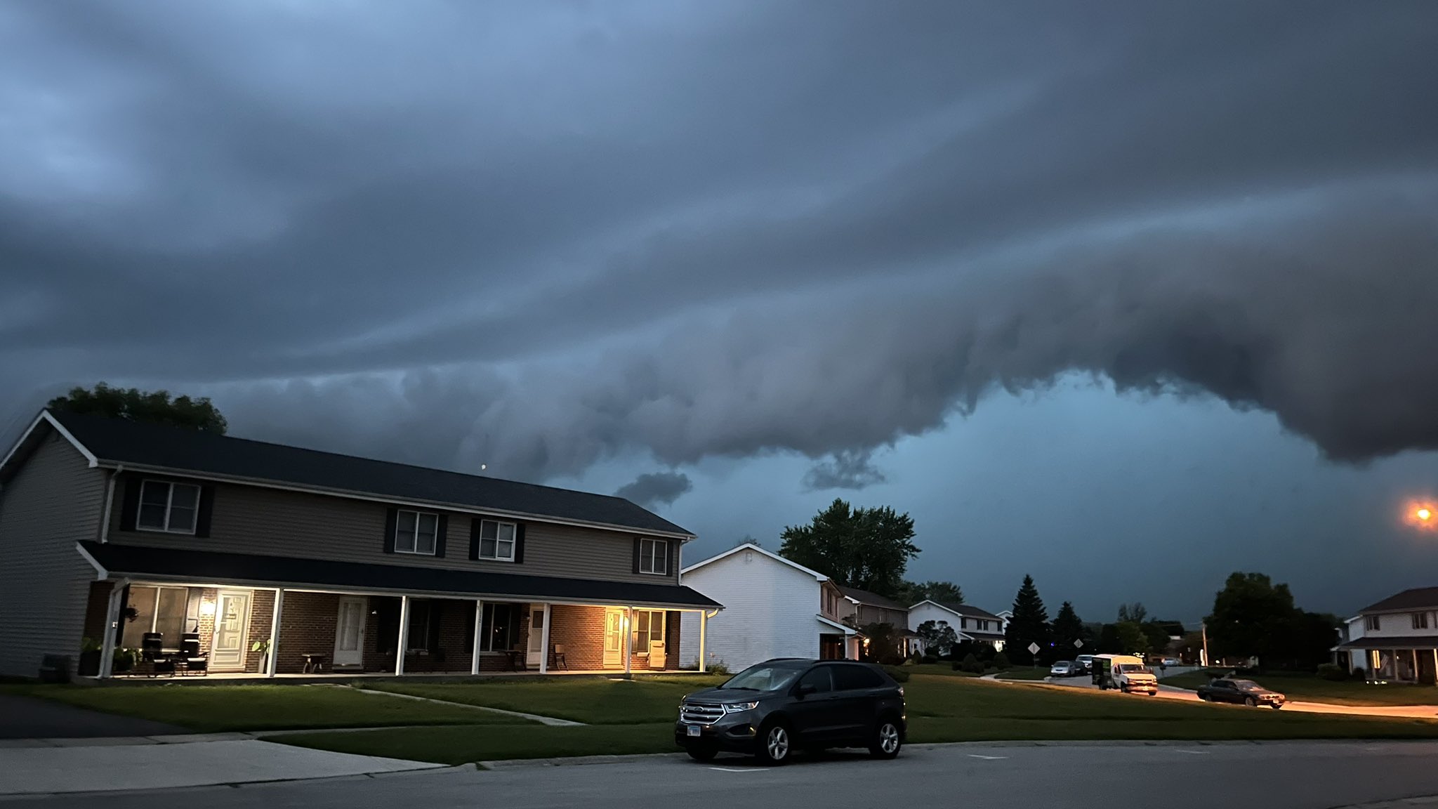
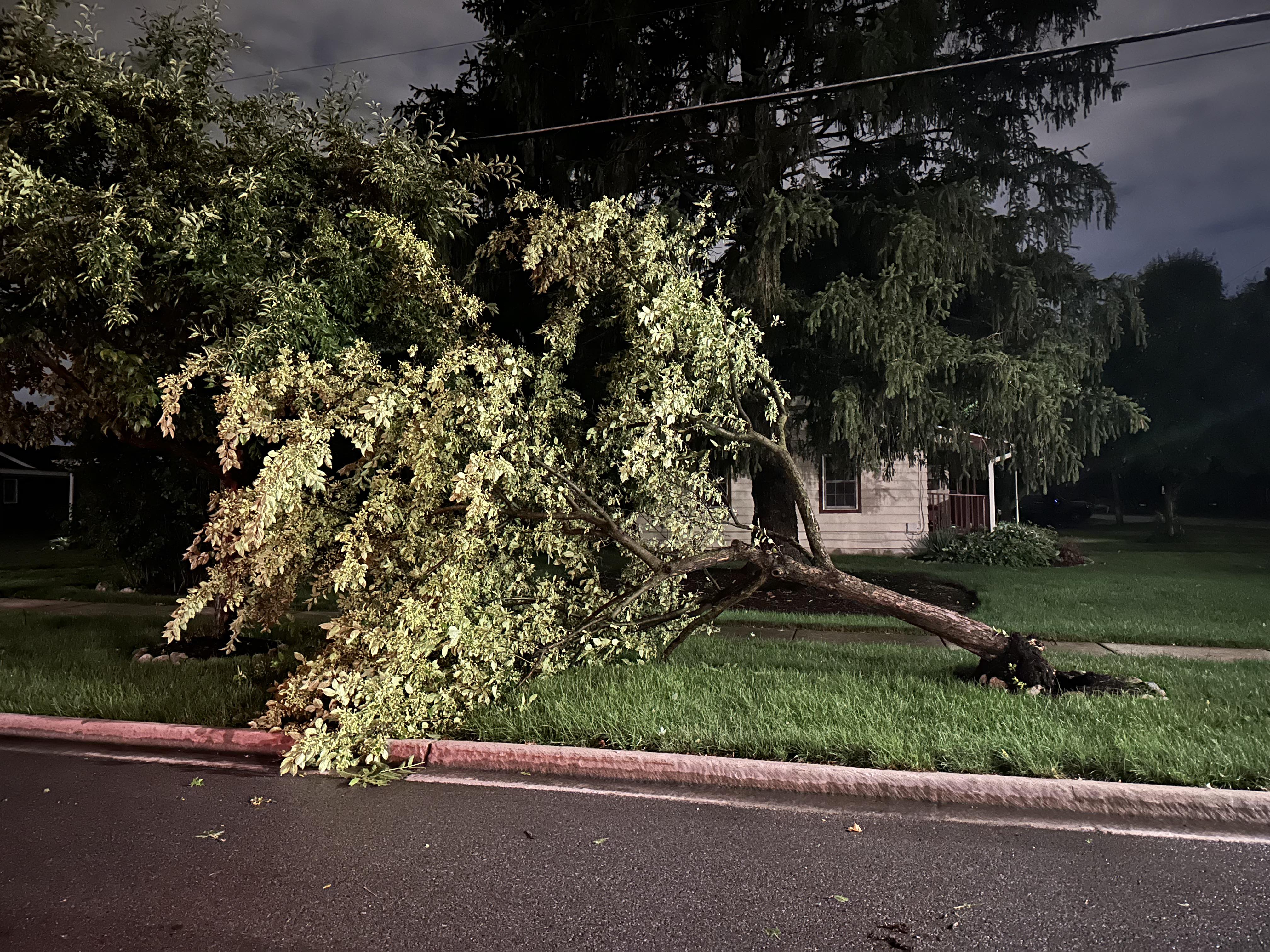
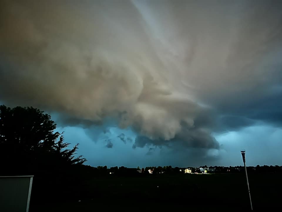
Photos
 |
|
 |
| Incoming shelf cloud over Plano, IL. Photo courtesy of Kevin Sheely. | Incoming shelf cloud over Yorkville, IL. Photo courtesy of Twitter user @CocoasCola. | Wind damage in Batavia, IL. Photo courtesy of the Batavia ESDA. |
 |
 |
 |
| Wind damage in Batavia, IL. Photo courtesy of the Batavia ESDA. | Wind damage in Schaumburg, IL. Photo courtesy of Landon Moeller. | Wind damage in Schaumburg, IL. Photo courtesy of Landon Moeller. |
 |
|
|
| Wind damage in Elk Grove Village, IL. Photo from NWS damage survey. | Tornado damage in Warrenville, IL. Photo courtesy of Joe Pudlik. | Tornado damage in Wheaton, IL. Photo courtesy of Joe Pudlik. |
 |
Media use of NWS Web News Stories is encouraged! Please acknowledge the NWS as the source of any news information accessed from this site. Additional recaps can be found on the NWS Chicago Past Events Page |
|