Overview
|
|
Fast Facts
For detailed information about this event, see The July 2 and September 17, 2023, Flash Flood Events in the Chicago Metro Area, a NWS Technical Paper which details the rainfall, flooding, and impacts.
Rainfall Reports
 |
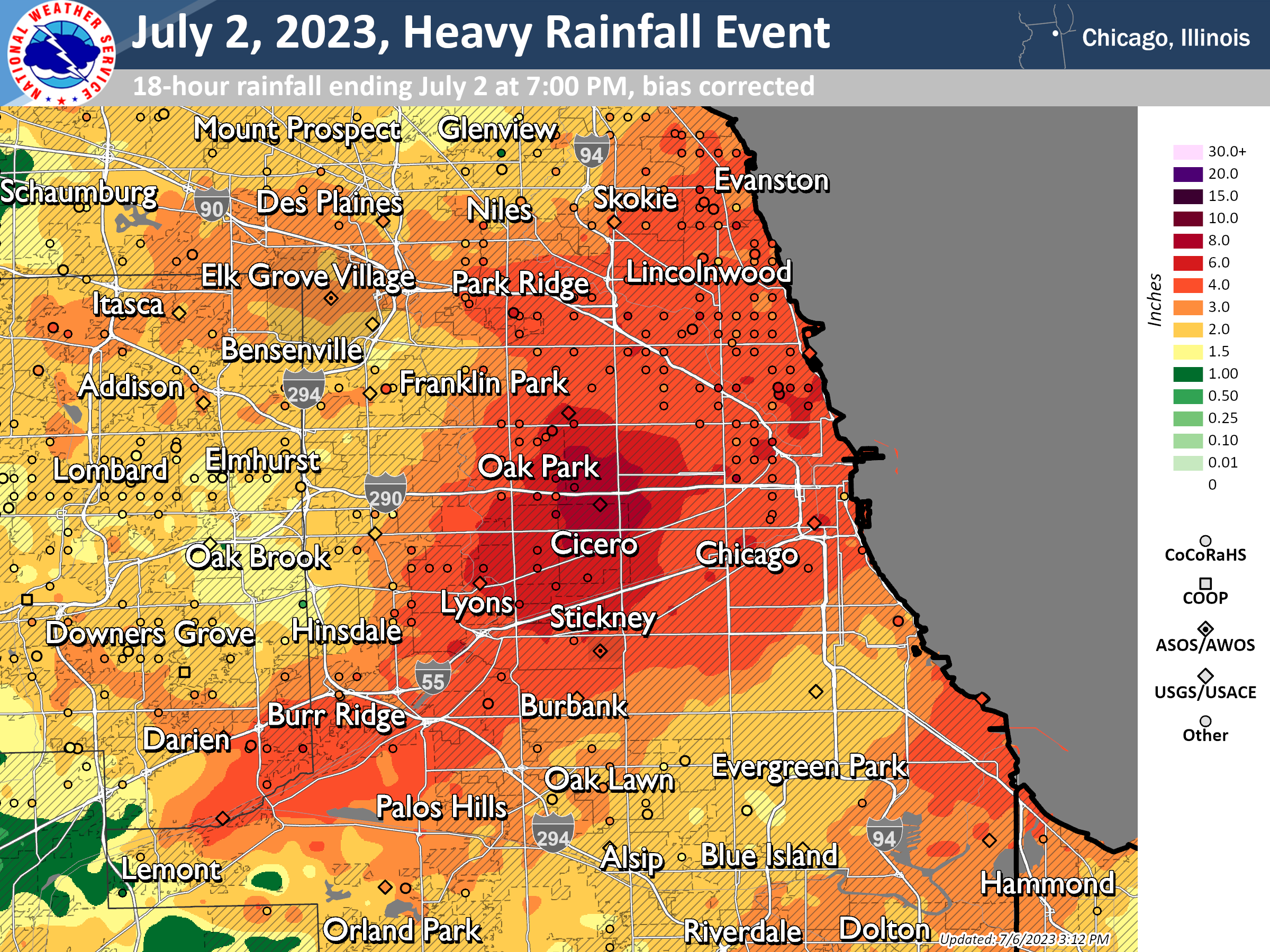 |
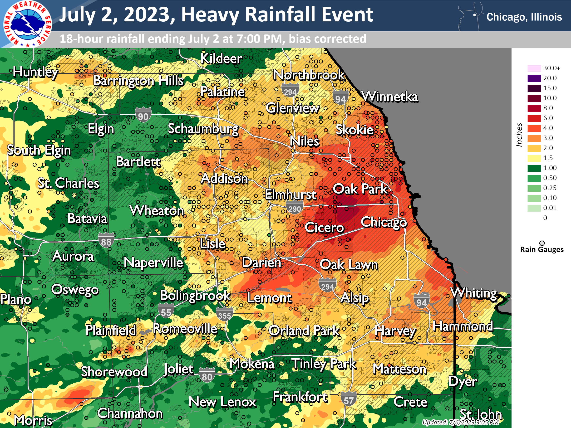
| Bias-corrected radar-estimated rainfall totals (midnight - 7 PM on Sunday, July 2, 2023) with rain gauges overlaid | Zoomed-in view of the bias-corrected rainfall estimates and gauge observations over Chicago |
 |
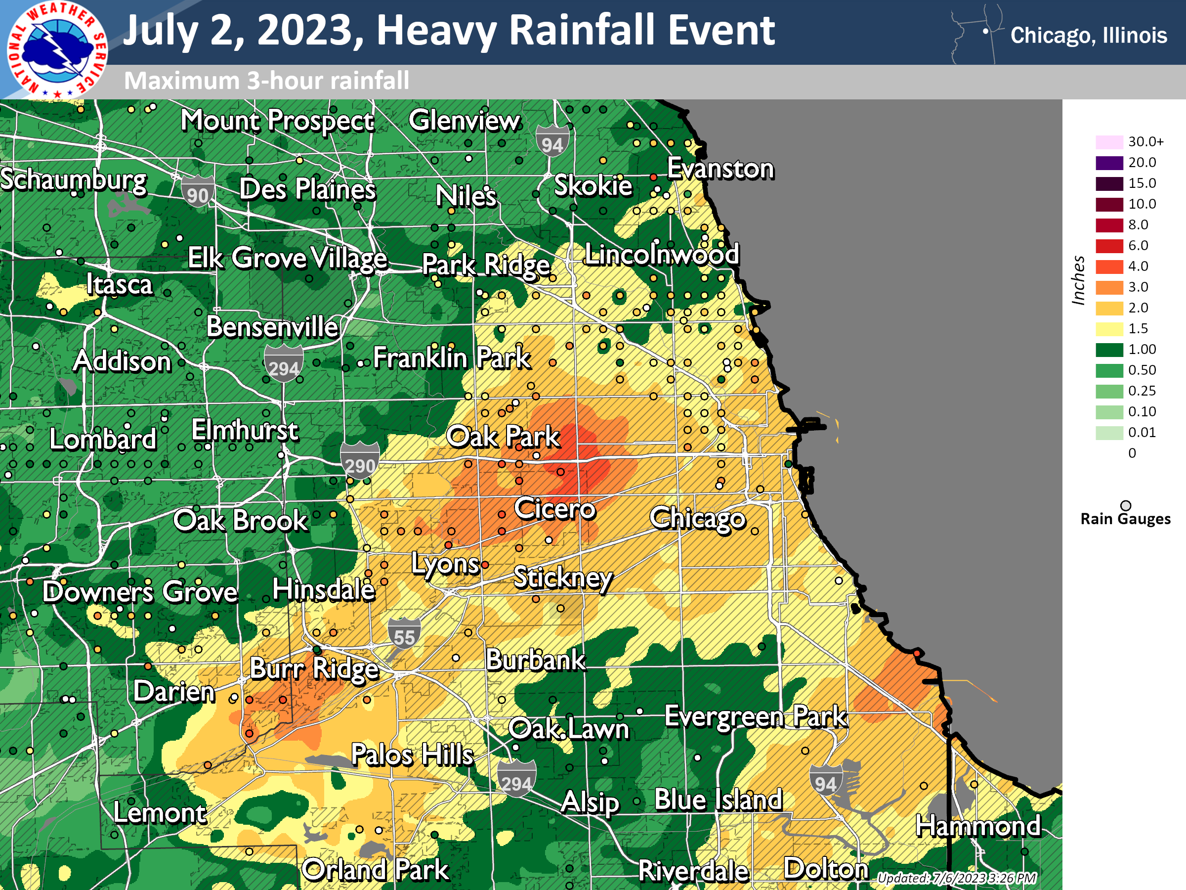 |
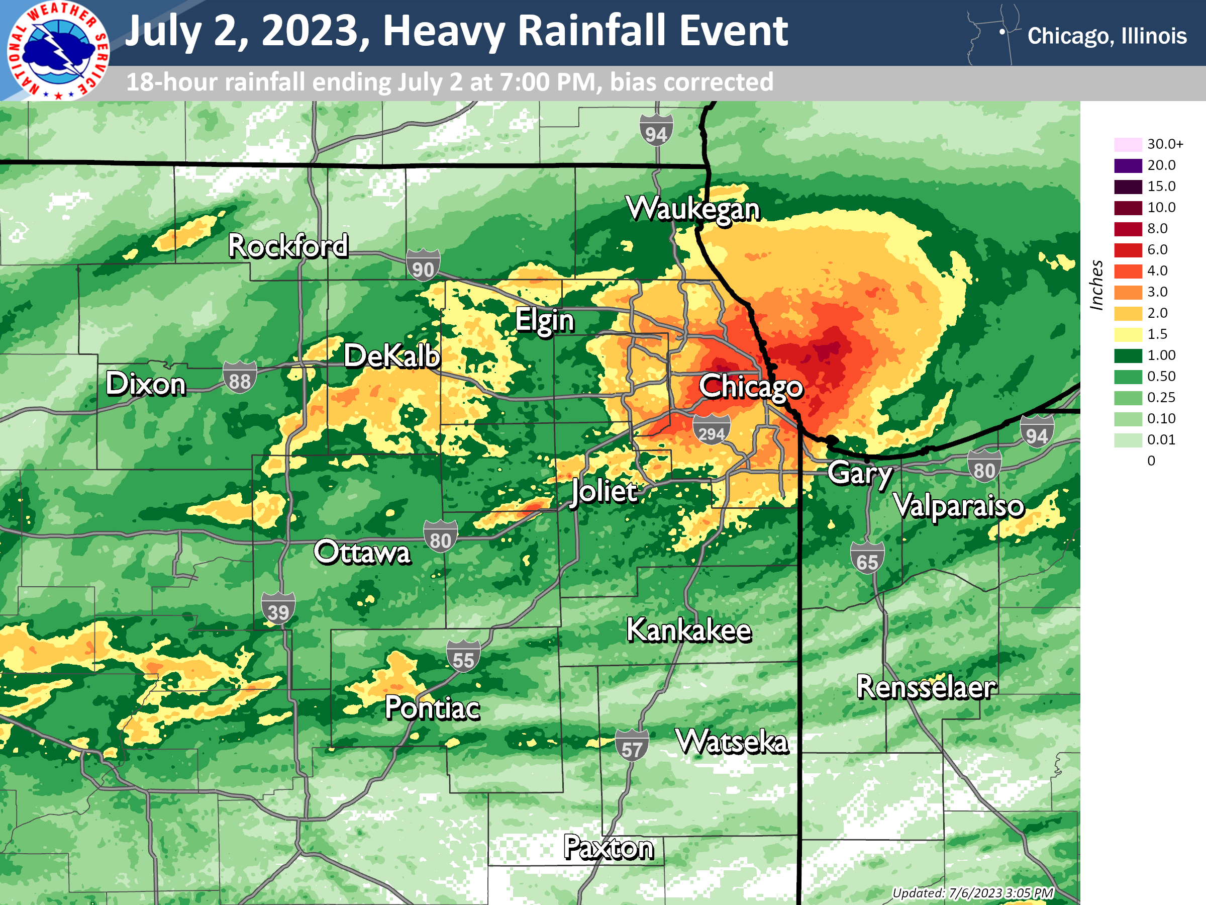
| Bias-corrected radar-estimated rainfall totals (midnight - 7 PM on Sunday, July 2, 2023) | Peak 3-hour rainfall amounts (with gauges overlaid) |
 |
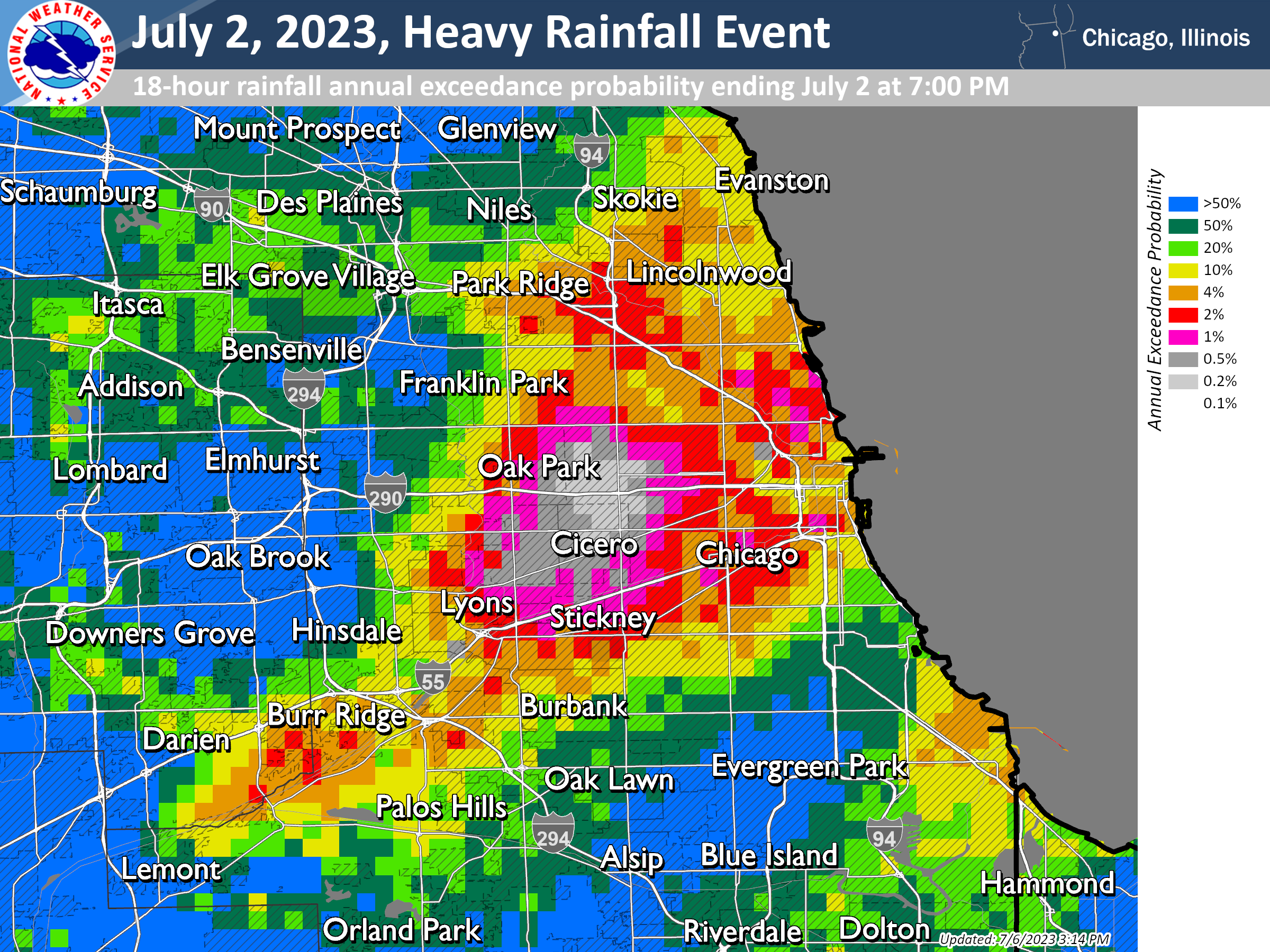 |
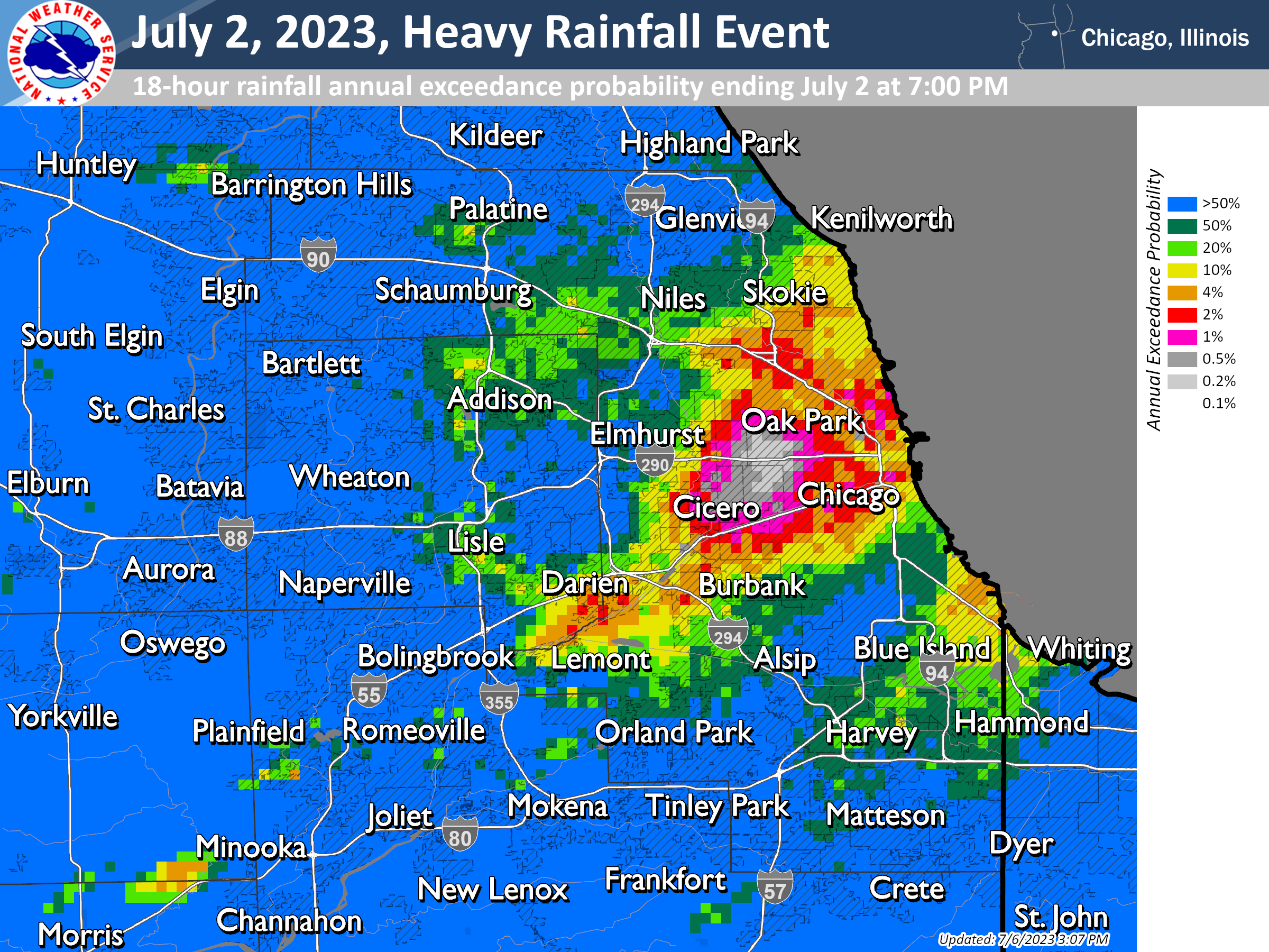
| 18-hour rainfall annual exceedance probability (midnight - 7 PM July 2, 2023) | Zoomed-in 18-hour rainfall annual exceedance probability (midnight - 7 PM July 2, 2023) |
            Public Information Statement
            National Weather Service Chicago IL
            252 PM CDT Mon Jul 3 2023 /352 PM EDT Mon Jul 3 2023/

            ...Observed Rainfall Amounts from 7/2/2023...

            Location                     Amount    Time/Date
            1 NNE Berwyn                 8.96 in   0630 PM 07/02
            1 N Cicero                   8.60 in   0600 PM 07/02
            2 E Garfield Park - Chicago  8.12 in   0630 PM 07/02
            1 WNW Lincoln Park - Chicago 7.89 in   0630 PM 07/02
            Forest View                  7.47 in   0630 PM 07/02
            Lincoln Park - Chicago       7.36 in   0630 PM 07/02
            Evanston                     7.09 in   0646 PM 07/02
            Chicago - McKinley Park      6.62 in   0655 PM 07/02
            1 N Midway Airport           6.34 in   0645 PM 07/02
            Oak Park                     6.04 in   0647 PM 07/02
            Riverside - Des Plaines R.   6.04 in   0545 PM 07/02
            2 NNW Bridgeport - Chicago   5.90 in   0630 PM 07/02
            1 WSW North Park - Chicago   5.55 in   0655 PM 07/02
            2 SW Lincoln Park - Chicago  5.02 in   0649 PM 07/02
            1 NE La Grange Park          4.99 in   0630 PM 07/02
            Chicago - Midway Airport     4.68 in   0653 PM 07/02
            La Grange                    4.68 in   0648 PM 07/02
            1 ESE South Chicago          4.62 in   0655 PM 07/02
            Northerly Island             4.53 in   0655 PM 07/02
            La Grange                    4.50 in   0630 PM 07/02
            1 N Norridge                 4.12 in   0645 PM 07/02
            1 ESE Evanston               4.07 in   0655 PM 07/02
            Wilmette                     4.06 in   0645 PM 07/02
            3 SW Midway                  4.01 in   Total from 7/02
            Chicago                      3.70 in   0645 PM 07/02
            Hickory Hills                3.68 in   0639 PM 07/02
            Burr Ridge                   3.64 in   0643 PM 07/02
            Algonquin                    3.58 in   0646 PM 07/02
            Plainfield                   3.51 in   0645 PM 07/02
            1 WNW Logan Square           3.45 in   0649 PM 07/02
            Harwood Heights              3.36 in   0655 PM 07/02
            Chicago - O`Hare Airport     3.35 in   0651 PM 07/02
            Chicago - Lincoln Park       3.35 in   0700 AM 07/02
            Bridgeport - Chicago         3.29 in   0655 PM 07/02
            Glenview                     3.28 in   0645 PM 07/02
            Kaneville 3 NNW              3.10 in   0700 AM 07/02
            Harwood Heights              3.01 in   0700 AM 07/02
            1 SE Algonquin               2.94 in   0930 AM 07/02
            Rosemont                     2.88 in   0645 PM 07/02
            Franklin Park 0.5 SSE        2.86 in   0800 AM 07/02
            Lisle                        2.83 in   0655 PM 07/02
            South Holland - Little Calum 2.81 in   0545 PM 07/02
            4 S Hainesville              2.78 in   0655 PM 07/02
            Wheaton                      2.70 in   0650 PM 07/02
            Glenwood                     2.64 in   0645 PM 07/02
            NIU AGRONOMY SHABONNA 5 NNE  2.61 in   0600 PM 07/02
            Bensenville                  2.60 in   0655 PM 07/02
            Deerfield                    2.57 in   0650 PM 07/02
            Chicago - Rogers Park        2.54 in   0800 AM 07/02
            Homer Glen                   2.53 in   0645 PM 07/02
            Marseilles 2 WSW             2.52 in   0800 AM 07/02
            1 WSW Bloomingdale           2.50 in   0655 PM 07/02
            Algonquin 2.1 W              2.50 in   0900 AM 07/02
            Rolling Meadows              2.48 in   0648 PM 07/02
            Hoffman Estates              2.41 in   0645 PM 07/02
            Deerfield - N. Br. Chicago R 2.40 in   0640 PM 07/02
            Munster - Little Calumet R.  2.40 in   0600 PM 07/02
            Deerfield - W. Fork N. Br. C 2.37 in   0640 PM 07/02
            Munster                      2.34 in   0645 PM 07/02
            Ottawa - Buffalo Rock SP     2.33 in   0727 AM 07/02
            Harvey                       2.28 in   0600 PM 07/02
            2 S Glen Ellyn               2.27 in   0655 PM 07/02
            2 WNW Mundelein              2.23 in   0654 PM 07/02
            Lake Forest                  2.17 in   0645 PM 07/02
            1 N Hammond                  2.16 in   0650 PM 07/02
            Oak Forest 1 NNW             2.16 in   0600 PM 07/02
            Phoenix                      2.08 in   0654 PM 07/02
            Hazel Crest                  2.07 in   0655 PM 07/02
            Hebron                       2.04 in   0645 PM 07/02
            Chicago - Albany Park        2.02 in   0700 AM 07/02

            Observations are collected from a variety of sources with varying
            equipment and exposures. We thank all volunteer weather observers
            for their dedication. Not all data listed are considered official.
|
Flooding Reports
|
Flooding in Cicero (Courtesy of @CipotaDeChicago on Twitter) |
A flooded basement in Cicero (Courtesy of @CiceroCasti on Twitter) |
|
Traffic being forced to turn around on I-290 outside of Chicago due to floodwater on the interstate (Courtesy of @kygirlinillinois on Twitter) |
    Preliminary Local Storm Report...Summary
    National Weather Service Chicago IL
    230 PM CDT Mon Jul 3 2023

    ..TIME...   ...EVENT...      ...CITY LOCATION...     ...LAT.LON...
    ..DATE...   ....MAG....      ..COUNTY LOCATION..ST.. ...SOURCE....
                ..REMARKS..

    0930 AM     Flood            2 S Downers Grove       41.77N 88.01W
    07/02/2023                   DuPage             IL   NWS Employee

                Up to 6 inches of standing water on Main
                Street between 63rd Street and 75th Street
                in Downers Grove.

    0940 AM     Flash Flood      1 SSE Austin - Chicago  41.87N 87.74W
    07/02/2023                   Cook               IL   Law Enforcement

                Cars stuck in flood waters near Cicero and
                5th Avenue.

    0940 AM     Flood            2 E Bolingbrook         41.70N 88.04W
    07/02/2023                   Will               IL   NWS Employee

                More than 6 inches of standing water at
                Joliet Road underpass at I-55.

    0941 AM     Flash Flood      1 WSW Garfield Park - C 41.87N 87.74W
    07/02/2023                   Cook               IL   Law Enforcement

                Water rescue reported in the 4600 block of
                Lexington Street.

    0955 AM     Flood            1 NE Lily Lake          41.96N 88.46W
    07/02/2023                   Kane               IL   Cocorahs

                Widespread field flooding reported with full
                drainage ditches. Rainfall of 2.19 inches in
                past 3 hours.

    0957 AM     Flash Flood      1 WSW Garfield Park - C 41.87N 87.74W
    07/02/2023                   Cook               IL   Public

                Flooded viaduct with cars stuck with water
                up to vehicle windows near Lexington Street
                and Kolmar Ave.

    1015 AM     Flash Flood      2 E Garfield Park - Chi 41.88N 87.68W
    07/02/2023                   Cook               IL   Public

                Multiple sections of I-290 with flooded
                lanes and flooded offramps between Kedzie
                Avenue and I-90.

    1015 AM     Flash Flood      1 SW River Forest       41.89N 87.82W
    07/02/2023                   Cook               IL   Public

                Multiple public reports of street flooding
                in Oak Park, Maywood, Elmwood Park areas.
                Relayed via mPing.

    1035 AM     Flood            1 SW Northlake          41.91N 87.92W
    07/02/2023                   Cook               IL   Public

                Several inches of standing water on Lake
                Street and North Avenue underpasses just
                east of I-294.

    1045 AM     Flash Flood      Archer Heights - Chicag 41.82N 87.72W
    07/02/2023                   Cook               IL   Broadcast Media

                I-55 closed due to flooding near Pulaski
                Road.

    1047 AM     Flash Flood      1 E Forest Park         41.87N 87.80W
    07/02/2023                   Cook               IL   Broadcast Media

                I-290 closed due to flooding near Forest
                Park.

    1048 AM     Flash Flood      Irving Park - Chicago   41.95N 87.74W
    07/02/2023                   Cook               IL   Public

                Public report received of multiple roadways
                blocked by water near Irving Park Road and
                Lowell Avenue.

    1055 AM     Flash Flood      La Grange Park          41.83N 87.87W
    07/02/2023                   Cook               IL   Public

                Multiple public reports received of flash
                flooding near La Grange.

    1111 AM     Flash Flood      1 ENE Cicero            41.85N 87.74W
    07/02/2023                   Cook               IL   Dept of Highways

                Pink Line CTA trains suspended due to
                flooding near Cicero.

    1112 AM     Flash Flood      Forest Park             41.87N 87.81W
    07/02/2023                   Cook               IL   Dept of Highways

                Blue Line CTA train service suspended due to
                flooding near Forest Park.

    0300 PM     Flash Flood      1 E Harwood Heights     41.97N 87.79W
    07/02/2023                   Cook               IL   Public

                Multiple roadways flooded and basements
                flooded near Gunnison Street and Nagle
                Avenue in Harwood Heights and Chicago.

    0300 PM     Flood            1 N Chicago Loop        41.89N 87.63W
    07/02/2023                   Cook               IL   Emergency Mngr

                Chicago OEMC reports low-lying walk ways of
                the Chicago Riverwalk have begun to flood.
                Time estimated.

    0432 PM     Flash Flood      Forest Park             41.87N 87.82W
    07/02/2023                   Cook               IL   Public

                Photo shared to social media shows stopped
                traffic along I-290 westbound at Des Plaines
                Avenue due to flooding.
|
 |
Media use of NWS Web News Stories is encouraged! Please acknowledge the NWS as the source of any news information accessed from this site. Additional recaps can be found on the NWS Chicago Past Events Page |
 |