Record setting heat is expected over the next several days from the Intermountain West through the northern Plains. Furthermore, fire weather concerns increase with dry and breezy conditions. Meanwhile, heavy rainfall and severe thunderstorm threats for the Ohio/Tennessee Valleys, central Appalachians and Southeast today. The threat shifts to central Gulf Coast and across central Texas this week. Read More >
Overview
|
 |
Storm Reports
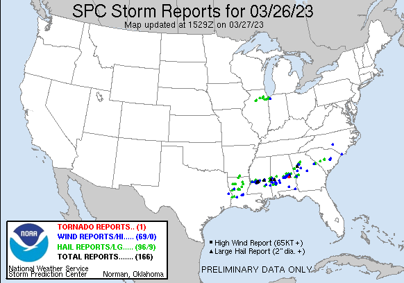 |
| Preliminary Storm Reports from March 26, 2023 |
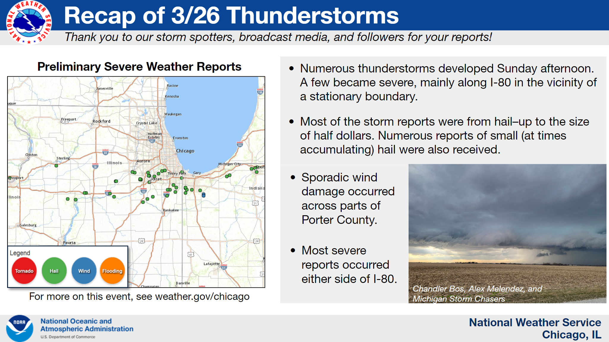
PRELIMINARY LOCAL STORM REPORT...SUMMARY NATIONAL WEATHER SERVICE CHICAGO IL 717 PM CDT SUN MAR 26 2023 ..TIME... ...EVENT... ...CITY LOCATION... ...LAT.LON... ..DATE... ....MAG.... ..COUNTY LOCATION..ST.. ...SOURCE.... ..REMARKS.. 0304 PM HAIL 1 SE DAYTON 41.37N 88.78W 03/26/2023 E0.75 INCH LA SALLE IL TRAINED SPOTTER 0329 PM HAIL MARSEILLES 41.33N 88.71W 03/26/2023 E0.70 INCH LA SALLE IL PUBLIC 0333 PM HAIL 3 NW SHOREWOOD 41.55N 88.24W 03/26/2023 E0.75 INCH WILL IL PUBLIC REPORT FROM MPING: DIME (0.75 IN.). 0350 PM HAIL 1 E PARK FOREST 41.48N 87.68W 03/26/2023 E0.50 INCH COOK IL PUBLIC SEVERAL REPORTS OF PEA TO DIME SIZE HAIL. 0355 PM HAIL 4 NW SHOREWOOD 41.55N 88.26W 03/26/2023 E1.25 INCH KENDALL IL TRAINED SPOTTER HAIL WAS STILL 1 IN DIAMETER ON THE GROUND 45 MINUTES AFTER HAIL FELL. TIME ESTIMATED BY RADAR. 0358 PM HAIL 4 SW PLAINFIELD 41.56N 88.26W 03/26/2023 M1.00 INCH WILL IL TRAINED SPOTTER TIME ESTIMATED BY RADAR. 0358 PM HAIL SHERIDAN 41.53N 88.68W 03/26/2023 E1.00 INCH LA SALLE IL TRAINED SPOTTER 0400 PM HAIL 4 SW PLAINFIELD 41.56N 88.26W 03/26/2023 E0.88 INCH WILL IL PUBLIC 0400 PM HAIL 1 W MONEE 41.42N 87.78W 03/26/2023 E0.50 INCH WILL IL PUBLIC PEA TO DIME SIZE HAIL. 0400 PM HAIL SHERIDAN 41.53N 88.67W 03/26/2023 E1.25 INCH LA SALLE IL PUBLIC PHOTO SHOWING HAIL LARGER THAN 1 IN DIAMETER IN SHERIDAN. TIME ESTIMATED BY RADAR. 0405 PM HAIL 1 ESE HEGESWISCH - CHIC 41.65N 87.53W 03/26/2023 E0.50 INCH COOK IL PUBLIC REPORT FROM MPING: HALF-INCH (0.50 IN.). 0407 PM HAIL 2 N HOMER GLEN 41.63N 87.94W 03/26/2023 E0.50 INCH WILL IL PUBLIC REPORT FROM MPING: HALF-INCH (0.50 IN.). 0407 PM HAIL 3 WSW PALOS PARK 41.66N 87.88W 03/26/2023 E0.50 INCH COOK IL PUBLIC REPORT FROM MPING: HALF-INCH (0.50 IN.). 0412 PM HAIL LANSING 41.57N 87.54W 03/26/2023 E0.88 INCH COOK IL PUBLIC 0412 PM HAIL PALOS PARK 41.67N 87.83W 03/26/2023 E0.50 INCH COOK IL PUBLIC 0415 PM HAIL 2 WSW ROMEOVILLE 41.64N 88.12W 03/26/2023 E1.00 INCH WILL IL PUBLIC SEVERAL REPORTS OF 1 HAIL IN ROMEOVILLE. TIME ESTIMATED BY RADAR. 0421 PM HAIL 1 W NWS CHICAGO-ROMEOVI 41.60N 88.11W 03/26/2023 E0.75 INCH WILL IL OFFICIAL NWS OBS PEA TO PENNY SIZE HAIL. 0422 PM HAIL 1 SW JOLIET 41.52N 88.10W 03/26/2023 E0.88 INCH WILL IL TRAINED SPOTTER 0424 PM HAIL 1 W NWS CHICAGO-ROMEOVI 41.60N 88.10W 03/26/2023 M0.88 INCH WILL IL PUBLIC 0430 PM HAIL 3 SW OSWEGO 41.65N 88.39W 03/26/2023 E0.75 INCH KENDALL IL PUBLIC REPORT FROM MPING: DIME (0.75 IN.). 0434 PM HAIL 3 E LOCKPORT 41.59N 88.01W 03/26/2023 E0.50 INCH WILL IL PUBLIC REPORT FROM MPING: HALF-INCH (0.50 IN.). 0437 PM HAIL 3 S OSWEGO 41.64N 88.35W 03/26/2023 E0.50 INCH KENDALL IL PUBLIC REPORT FROM MPING: HALF-INCH (0.50 IN.). 0440 PM HAIL BRAIDWOOD 41.26N 88.21W 03/26/2023 E0.75 INCH WILL IL EMERGENCY MNGR 0450 PM HAIL 1 SE WILMINGTON 41.30N 88.13W 03/26/2023 E0.88 INCH WILL IL BROADCAST MEDIA 0451 PM HAIL 1 ENE SYMERTON 41.33N 88.04W 03/26/2023 E1.00 INCH WILL IL PUBLIC NICKEL TO QUARTER SIZE HAIL FALLING. 0504 PM HAIL PEOTONE 41.34N 87.79W 03/26/2023 M1.00 INCH WILL IL TRAINED SPOTTER REPORT OF THREE-QUARTER TO ONE INCH DIAMETER HAIL. 0512 PM HAIL 1 E MONEE 41.42N 87.74W 03/26/2023 E0.88 INCH WILL IL PUBLIC TIME ESTIMATED BY RADAR. 0520 PM HAIL CRETE 41.45N 87.63W 03/26/2023 E0.70 INCH WILL IL PUBLIC 0523 PM HAIL 1 WNW GOODENOW 41.39N 87.65W 03/26/2023 U0.75 INCH WILL IL PUBLIC REPORT FROM MPING: DIME (0.75 IN.). 0525 PM HAIL ST. JOHN 41.45N 87.47W 03/26/2023 M1.00 INCH LAKE IN COCORAHS 0535 PM HAIL 1 S ST. JOHN 41.44N 87.47W 03/26/2023 E0.75 INCH LAKE IN PUBLIC REPORT FROM MPING: DIME (0.75 IN.). 0535 PM HAIL 2 WNW CEDAR LAKE 41.38N 87.47W 03/26/2023 E0.75 INCH LAKE IN TRAINED SPOTTER 0537 PM HAIL 2 SSE ST. JOHN 41.42N 87.45W 03/26/2023 E1.00 INCH LAKE IN TRAINED SPOTTER PEA TO JUST OVER QUARTER SIZE HAIL FELL WITH WIND GUSTS OF 30 TO 40 MPH. 0538 PM HAIL CROWN POINT 41.42N 87.36W 03/26/2023 E1.00 INCH LAKE IN PUBLIC 0555 PM HAIL LAKES OF THE FOUR SEASO 41.41N 87.22W 03/26/2023 E0.75 INCH LAKE IN TRAINED SPOTTER 0548 PM TSTM WND DMG 2 WSW BOONE GROVE 41.34N 87.16W 03/26/2023 PORTER IN PUBLIC WOODEN POWERLINE POLES SNAPPED. && $$ |
Meteorology and Photos
 |
 |
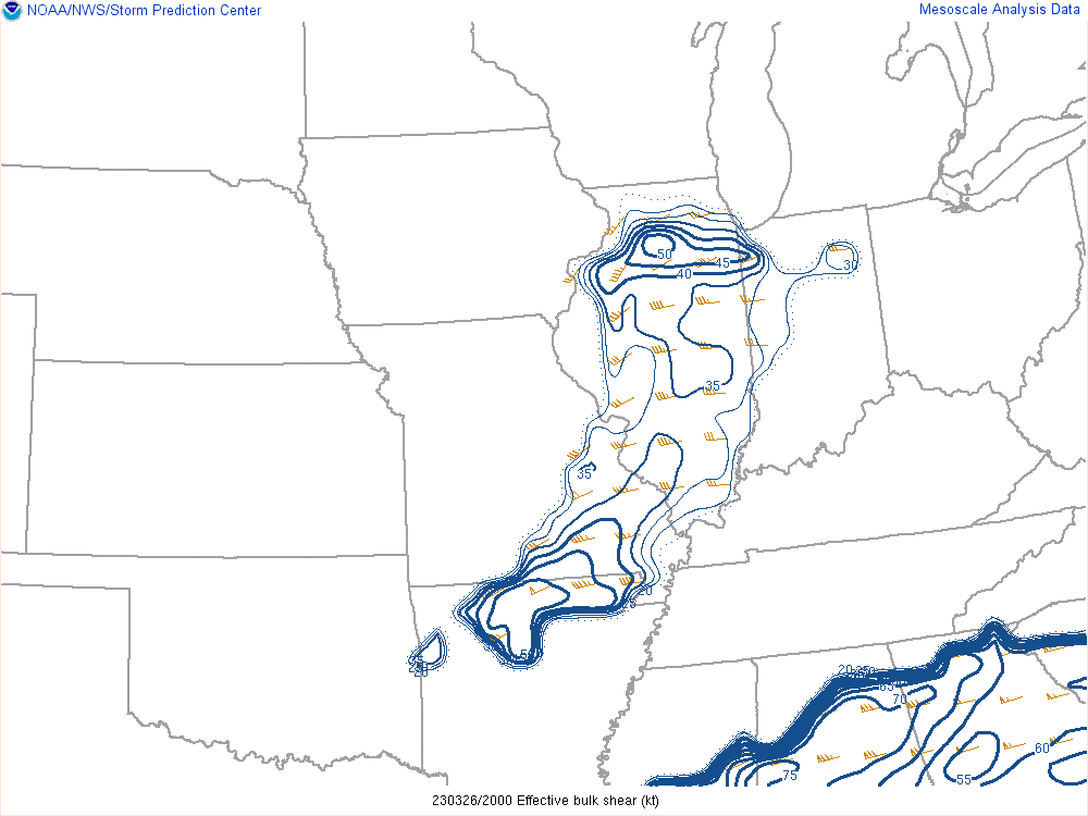 |
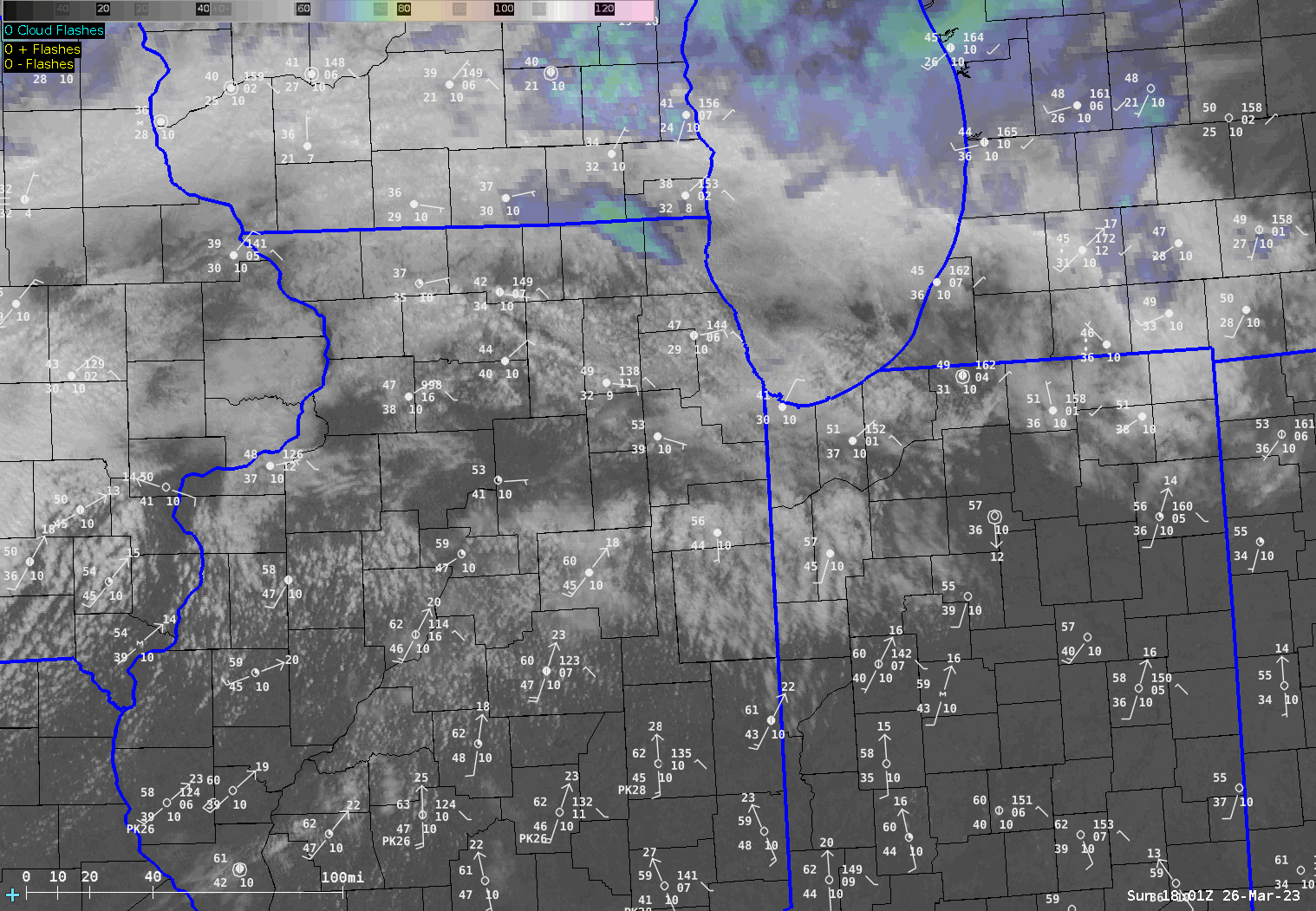
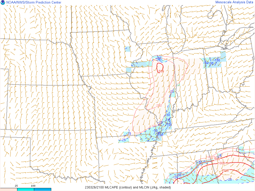
| Satellite loop with surface observations overlaid. Loop runs from 1 to 6 PM CDT. | Analysis of mixed-layer CAPE (a measure of instability) showing just enough to support low-topped thunderstorms. | Analysis of deep layer wind shear showing values of 40-50 kt, supportive of organized supercells. |
|
|
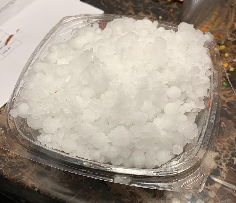 |
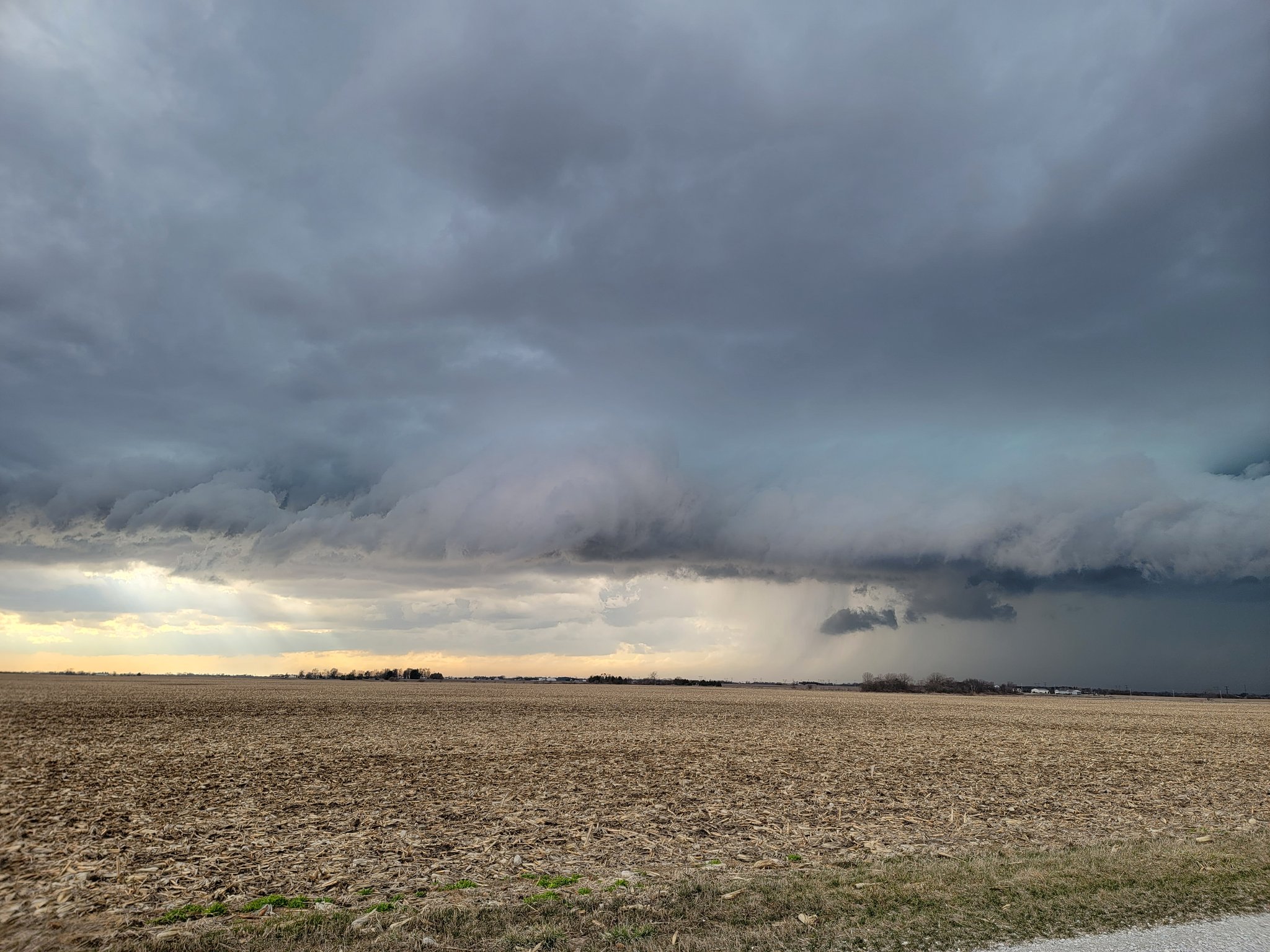
| Storm near Beecher, IL (courtesy of Michigan Storm Chasers: Chandler Bos and Alex Melendez) | Accumulating hail from Lansing, IL (courtesy of @michaelwx6) |
Additional Info
 |
Media use of NWS Web News Stories is encouraged! Please acknowledge the NWS as the source of any news information accessed from this site. Additional recaps can be found on the NWS Chicago Past Events Page |
|