Record setting heat is expected over the next several days from the Intermountain West through the northern Plains. Furthermore, fire weather concerns increase with dry and breezy conditions. Meanwhile, heavy rainfall and severe thunderstorm threats for the Ohio/Tennessee Valleys, central Appalachians and Southeast today. The threat shifts to central Gulf Coast and across central Texas this week. Read More >
|
|
Fast Facts
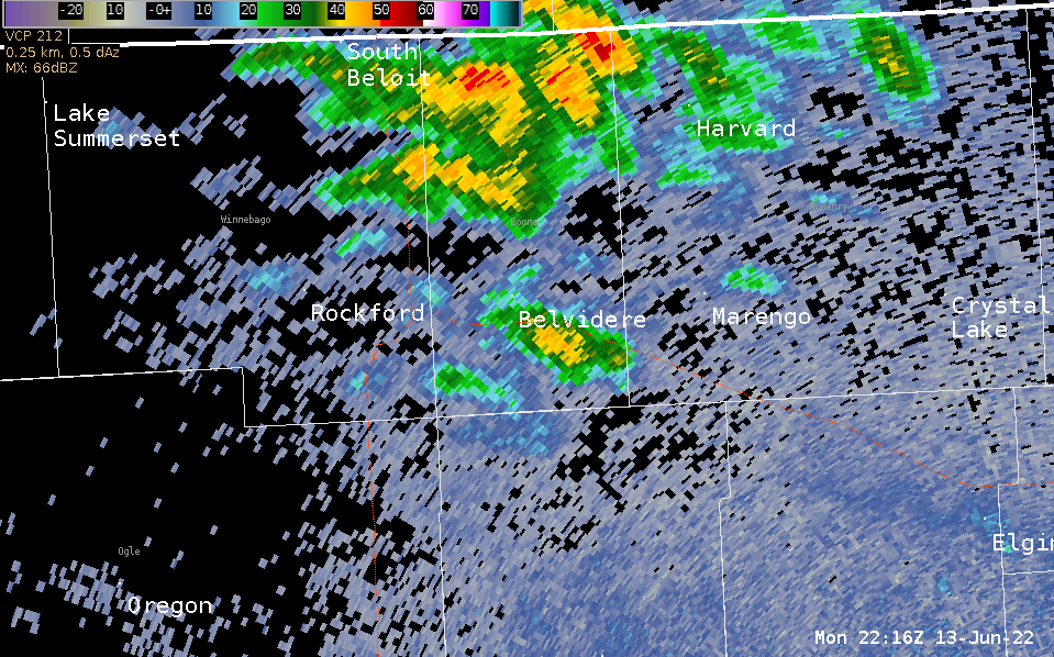
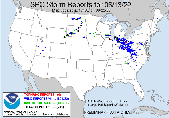
A strong supercell thunderstorm moved over 100 miles from northeast Illinois to northwest Indiana during the late afternoon and evening (5:30-8:30 P.M.) of Monday, June 13.
A wide swath of wind damage, some of which was significant, occurred along the path of this storm, and an NWS Storm Damage Survey Team determined that some of the damage was consistent with scattered to widespread wind speeds of 75-95 mph. The survey team also determined that two tornadoes, both EF-0s, occurred first in Hoffman Estates and then later in Schaumburg and Roselle.
Some of the most severe wind damage was non-tornadic and occurred in Streamwood, Schaumburg, Roselle, and within a corridor extending from Elk Grove Village through Lyons in west central Cook County.
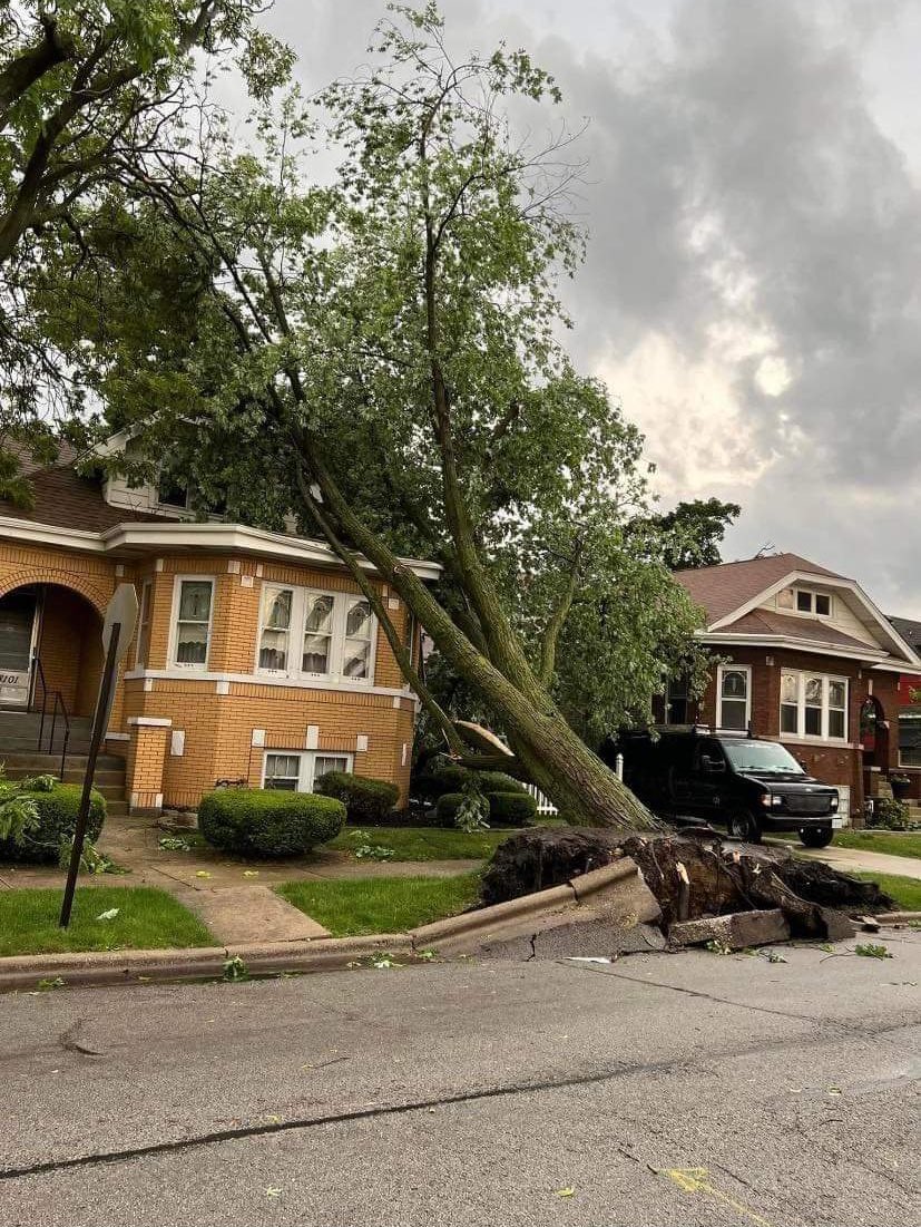
Hundreds of trees were downed or damaged, which also resulted in widespread power outages. There was some structural damage, which included roofs being partially blown off apartment buildings in Westchester and in Bellwood. Two injuries were reported by local media. A small plane was also flipped over at Schaumburg Regional Airport.
O'Hare Airport gusted to 84 mph while Midway Airport gusted to 69 mph with this storm. The 84 mph wind gust at Chicago O'Hare tied the 2nd strongest gust ever measured at the O'Hare Airport weather station.
A Tornado Watch was issued at 5:50 P.M. for all of northeast Illinois and northwest Indiana, and multiple Tornado Warnings were issued for the storm as well.
This supercell storm formed along a warm front at the periphery of a hot and very humid air mass that was spreading northward.
This storm had an impressive depth, with a top over 60,000 ft based on data from multiple radars, and may have been over 65,000 ft to near 70,000 ft. Radar beam widths and heights at such a high elevation become very wide, so it's difficult to determine a specific height. No matter what, this storm was within the upper echelon of storm tops for mid-latitude, non-tropical thunderstorms
Storm Reports
 |
PRELIMINARY LOCAL STORM REPORT...SUMMARY
NATIONAL WEATHER SERVICE CHICAGO IL
310 PM CDT THU JUN 16 2022
..TIME... ...EVENT... ...CITY LOCATION... ...LAT.LON...
..DATE... ....MAG.... ..COUNTY LOCATION..ST.. ...SOURCE....
..REMARKS..
0552 PM TSTM WND DMG LAKE IN THE HILLS 42.19N 88.34W
06/13/2022 MCHENRY IL PUBLIC
POWER POLE DOWNED ONTO TREES ALONG RANDALL
RD. TIME ESTIMATED FROM RADAR.
0559 PM TSTM WND DMG CARPENTERSVILLE 42.12N 88.27W
06/13/2022 KANE IL FIRE DEPT/RESCUE
WIDESPREAD DAMAGE TO TREES AND POWERLINES IN
CARPENTERSVILLE. A FEW TREES SNAPPED,
NUMEROUS SMALL BRANCHES DOWNED. WORST DAMAGE
EAST OF THE FOX RIVER BETWEEN IL-68 AND
IL-62. INFORMATION RELAYED BY FIRE
DEPARTMENT. TIME ESTIMATED BY RADAR.
0600 PM TSTM WND DMG SLEEPY HOLLOW 42.09N 88.31W
06/13/2022 KANE IL PUBLIC
SEVERAL TREES WERE BLOWN DOWN IN THE WEST
DUNDEE AND SLEEPY HOLLOW AREA.
0601 PM TSTM WND DMG CARPENTERSVILLE 42.12N 88.26W
06/13/2022 KANE IL PUBLIC
PHOTOS SHARED ON SOCIAL MEDIA SHOWED TREE
LIMBS BLOWN DOWN.
0605 PM TSTM WND DMG ELGIN 42.04N 88.28W
06/13/2022 KANE IL TRAINED SPOTTER
CORRECTS TIME OF PREVIOUS TSTM WND DMG
REPORT FROM ELGIN. BETWEEN SPRING STREET AND
DOUGLAS AVENUE, A LARGE TREE ESTIMATED 4-5
FEET IN DIAMETER SNAPPED AND FELL ONTO
NEARBY POWER POLES. SEVERAL OTHER MEDIUM TO
LARGE SIZED TREE LIMBS DOWN IN THE AREA.
TIME ESTIMATED FROM RADAR.
0611 PM TSTM WND DMG 2 S VERNON HILLS 42.20N 87.97W
06/13/2022 LAKE IL PUBLIC
5 INCH DIAMETER TREE LIMB SNAPPED OFF TREE.
TIME ESTIMATED FROM RADAR.
0614 PM TSTM WND GST STREAMWOOD 42.03N 88.18W
06/13/2022 E75 MPH COOK IL NWS STORM SURVEY
WIDESPREAD TREE DAMAGE ACROSS STREAMWOOD.
PEAK WINDS ESTIMATED TO BE AROUND 75 MPH.
0615 PM TSTM WND DMG 1 NW STREAMWOOD 42.03N 88.19W
06/13/2022 COOK IL PUBLIC
NUMEROUS MEDIUM SIZED OR LARGER TREE LIMBS
DOWN ALONG TANGLEWOOD DRIVE JUST SOUTH OF
SCHAUMBURG ROAD. REPORT RELAYED VIA TWITTER.
0616 PM FUNNEL CLOUD 2 NW STREAMWOOD 42.04N 88.20W
06/13/2022 COOK IL PUBLIC
FUNNEL CLOUD WAS REPORTED NEAR ROUTE 58 AND
59 IN STREAMWOOD, IL.
0617 PM TSTM WND DMG 1 E HOFFMAN ESTATES 42.05N 88.08W
06/13/2022 COOK IL EMERGENCY MNGR
LARGE BRANCHES SNAPPED AND BLOWN TO WEST.
TIME ESTIMATED BY RADAR.
0625 PM TSTM WND DMG 1 WNW ROSELLE 41.99N 88.10W
06/13/2022 COOK IL BROADCAST MEDIA
CORRECTS PREVIOUS TSTM WND DMG REPORT FROM 1
WNW ROSELLE. ONE SMALL PLANE FLIPPED OVER
AND ANOTHER SMALL PLANE PUSHED INTO A FENCE.
TIME ESTIMATED FROM RADAR.
0625 PM TSTM WND DMG SCHAUMBURG 42.03N 88.08W
06/13/2022 COOK IL NWS EMPLOYEE
NUMEROUS LARGE TREE LIMBS REPORTED DOWN ON
THE SOUTH AND WEST SIDES OF TOWN.
0625 PM TSTM WND DMG 1 N ROSELLE 42.00N 88.08W
06/13/2022 COOK IL NWS EMPLOYEE
TREE DAMAGE. TIME ESTIMATED BY RADAR.
0627 PM TSTM WND DMG 1 ESE ARLINGTON HEIGHTS 42.07N 87.96W
06/13/2022 COOK IL EMERGENCY MNGR
MATURE TREES DOWNED IN ARLINGTON HEIGHTS.
TIME ESTIMATED FROM RADAR.
0627 PM TORNADO 2 S SCHAUMBURG 42.00N 88.08W
06/13/2022 COOK IL NWS STORM SURVEY
UPDATES PREVIOUS TORNADO REPORT FROM 2 S
SCHAUMBURG. AN NWS DAMAGE SURVEY DETERMINED
THAT AN EF-0 TORNADO TOUCHED DOWN IN
UNINCORPORATED SCHAUMBURG, CROSSED THE
ELGIN-O`HARE EXPRESSWAY INTO ROSELLE, AND
LIFTED JUST PRIOR TO ENTERING MEDINAH.
DAMAGE WAS SPORADIC ALONG THE TORNADO`S PATH
AND CONSISTED OF PART OF THE ROOF OF A
BUSINESS GETTING PEELED BACK IN TWO
DIFFERENT DIRECTIONS WITH THE REST OF THE
DAMAGE BEING CONFINED TO TREES.
0628 PM TSTM WND GST MOUNT PROSPECT 42.07N 87.94W
06/13/2022 E60 MPH COOK IL TRAINED SPOTTER
0628 PM HAIL MOUNT PROSPECT 42.07N 87.94W
06/13/2022 E1.00 INCH COOK IL TRAINED SPOTTER
0629 PM TSTM WND DMG ROSELLE 41.98N 88.08W
06/13/2022 DUPAGE IL PUBLIC
TREE LIMBS DOWNED ON ROADWAYS.
0630 PM TSTM WND DMG ROSELLE 41.99N 88.07W
06/13/2022 DUPAGE IL EMERGENCY MNGR
EMA REPORTED A TREE FELL ONTO A HOUSE
CAUSING DAMAGE TO THE STRUCTURE. TIME
ESTIMATED BY RADAR.
0632 PM TSTM WND DMG 1 ENE ELK GROVE VILLAGE 42.01N 87.97W
06/13/2022 COOK IL PUBLIC
VIDEO SHARED VIA SOCIAL MEDIA SHOWS ROOFING
MATERIAL BLOWN OFF OF INDUSTRIAL BUILDING
FROM NORTH TO SOUTH NEAR LOUIS AVENUE AND
LIVELY BOULEVARD IN ELK GROVE VILLAGE. TIME
ESTIMATED BY RADAR.
0636 PM HAIL 2 SE KILDEER 42.15N 88.02W
06/13/2022 E1.00 INCH COOK IL TRAINED SPOTTER
AT ROUTE 53 AND LAKE COOK ROAD.
0642 PM HAIL OHARE AIRPORT 41.98N 87.91W
06/13/2022 E0.70 INCH COOK IL ASOS
0644 PM TSTM WND DMG BENSENVILLE 41.95N 87.93W
06/13/2022 DUPAGE IL EMERGENCY MNGR
MULTIPLE TREES DOWNED AND POWER POLES
DAMAGED IN BENSENVILLE.
0644 PM TSTM WND GST OHARE AIRPORT 41.98N 87.90W
06/13/2022 M84 MPH COOK IL ASOS
CORRECTS PREVIOUS NON-TSTM WND GST REPORT
FROM OHARE AIRPORT. ASOS STATION KORD
CHICAGO OHARE.
0645 PM TSTM WND DMG 1 WSW ELMHURST 41.89N 87.95W
06/13/2022 DUPAGE IL PUBLIC
PHOTO SHARED ON SOCIAL MEDIA SHOWED LARGE
TREE LIMBS BLOWN DOWN WEST OF ELMHURST
COLLEGE.
0645 PM TSTM WND GST PARK RIDGE 42.01N 87.84W
06/13/2022 E70 MPH COOK IL TRAINED SPOTTER
0645 PM TSTM WND DMG UPTOWN - CHICAGO 41.97N 87.65W
06/13/2022 COOK IL TRAINED SPOTTER
SEVERAL TREE BRANCHES DOWNED JUST NORTHWEST
OF MONTROSE HARBOR. TIME ESTIMATED BY RADAR.
0645 PM TSTM WND DMG PARK RIDGE 42.01N 87.84W
06/13/2022 COOK IL TRAINED SPOTTER
NUMEROUS LIMBS REPORTED DOWN IN TOWN.
0645 PM HAIL PARK RIDGE 42.01N 87.84W
06/13/2022 E1.00 INCH COOK IL TRAINED SPOTTER
0646 PM TSTM WND DMG 1 E FRANKLIN PARK 41.94N 87.86W
06/13/2022 COOK IL PUBLIC
REPORT FROM MPING: TREES UPROOTED OR
SNAPPED.
0647 PM TSTM WND DMG 1 SSW NORTHLAKE 41.90N 87.91W
06/13/2022 COOK IL LAW ENFORCEMENT
ROOF TILES BLOWN OFF AND WINDOW BROKEN AT
VALUE CITY IN NORTHLAKE. WIRES DOWNED AND
TREE DAMAGE ALSO REPORTED IN TOWN. TIME
ESTIMATED FROM RADAR.
0648 PM TSTM WND DMG STONE PARK 41.90N 87.88W
06/13/2022 COOK IL UNKNOWN
DELAYED REPORT, TIME ESTIMATED BY RADAR.
VILLAGE CLERK OF STONE PARK REPORTS MULTIPLE
TREES DAMAGED ACROSS THE VILLAGE, INCLUDING
SEVERAL LARGE LIMBS ABOUT 1 FOOT IN
DIAMETER. DAMAGE TO SHINGLES AT ONE
RESIDENCE. MULTIPLE CARS DAMAGED BY FALLING
BRANCHES.
0649 PM TSTM WND DMG BERKELEY 41.88N 87.91W
06/13/2022 COOK IL PUBLIC
MULTIPLE TREES DOWNED IN BERKELEY. TIME
ESTIMATED FROM RADAR.
0650 PM TSTM WND DMG ALBANY PARK - CHICAGO 41.97N 87.72W
06/13/2022 COOK IL PUBLIC
TREE LIMBS DOWN AND SOME SHINGLES BLOWN OFF
ROOFS. REPORT RELAYED VIA TWITTER. TIME
ESTIMATED.
0651 PM TSTM WND GST BELLWOOD 41.88N 87.88W
06/13/2022 E95 MPH COOK IL NWS STORM SURVEY
*** 2 INJ ***
SWATH OF WIND DAMAGE ACROSS WESTERN COOK
COUNTY, INCLUDING A ROOF OFF AN APARTMENT
COMPLEX IN BELLWOOD. PEAK WINDS WERE
ESTIMATED TO BE BETWEEN 90 AND 95 MPH.
0654 PM TSTM WND GST 1 NE WESTCHESTER 41.86N 87.88W
06/13/2022 E90 MPH COOK IL NWS STORM SURVEY
TWO APARTMENT BUILDINGS ALONG WESTCHESTER
BLVD WITH ROOF COVERING PEELED BACK AND
BLOWN DOWN TO STREET LEVEL. LARGE
APPROXIMATELY 3 FOOT DIAMETER SOFTWOOD TREE
UPROOTED. PEAK WINDS ESTIMATED TO BE AROUND
90 MPH.
0654 PM HEAVY RAIN 2 E SCHAUMBURG 42.03N 88.04W
06/13/2022 M1.26 INCH COOK IL COCORAHS
RAINFALL IN 16 MINUTES.
0654 PM TSTM WND DMG WESTCHESTER 41.85N 87.89W
06/13/2022 COOK IL PUBLIC
PHOTO SHARED ON SOCIAL MEDIA OF A LARGE TREE
SNAPPED WHICH FELL ONTO A CAR.
0654 PM TSTM WND DMG WESTCHESTER 41.86N 87.88W
06/13/2022 COOK IL PUBLIC
LARGE TREE DOWNED FELL ONTO HOUSES AND CARS.
LOSS OF ROOF COVERING ON MULTIPLE HOMES.
LOCATION MANNHEIM RD AND WATERFORD DR.
REPORT RELAYED VIA FACEBOOK. TIME ESTIMATED.
0655 PM HAIL 1 SSW MELROSE PARK 41.89N 87.86W
06/13/2022 E1.00 INCH COOK IL EMERGENCY MNGR
0655 PM TSTM WND DMG 1 ENE LA GRANGE PARK 41.84N 87.86W
06/13/2022 COOK IL PUBLIC
PHOTOS SHARED ON SOCIAL MEDIA SHOWED
MULTIPLE TREES, TREE LIMBS AND POWER LINES
BLOWN DOWN, NORTH OF 31ST BETWEEN LA GRANGE
ROAD AND MAPLE AVENUE.
0655 PM TSTM WND DMG 1 S BROADVIEW 41.85N 87.86W
06/13/2022 COOK IL PUBLIC
A PHOTO SHARED ON SOCIAL MEDIA SHOWED
UTILITY POLES SNAPPED AND BLOCKING A STREET
NEAR 21ST AVENUE AND CERMAK ROAD.
0655 PM TSTM WND DMG NORTH RIVERSIDE 41.85N 87.82W
06/13/2022 COOK IL PUBLIC
PHOTOS SHARED ON SOCIAL MEDIA SHOWED LARGE
TREE LIMBS BLOWN DOWN.
0655 PM TSTM WND DMG 1 E LINCOLN PARK - CHIC 41.92N 87.63W
06/13/2022 COOK IL PUBLIC
SEVERAL DOWNED TREE LIMBS IN LINCOLN PARK
SOUTH OF FULLERTON PARKWAY AND LAKE SHORE
DRIVE. TIME ESTIMATED BY RADAR.
0655 PM TSTM WND DMG 1 SSW BROADVIEW 41.85N 87.86W
06/13/2022 COOK IL PUBLIC
NUMEROUS POWERLINES AND POWER POLES SNAPPED
AND DOWNED AT 25TH AVE AND CERMAK RD. REPORT
RELAYED VIA TWITTER. TIME ESTIMATED.
0655 PM TSTM WND DMG 1 WSW RIVERSIDE 41.83N 87.83W
06/13/2022 COOK IL PUBLIC
18 INCH DIAMETER HARDWOOD TREE TRUNK SNAPPED
AND FELL ONTO POWERLINES. REPORT RELAYED VIA
TWITTER. TIME ESTIMATED.
0657 PM TSTM WND DMG RIVERSIDE 41.83N 87.82W
06/13/2022 COOK IL FIRE DEPT/RESCUE
HUNDREDS OF TREES WERE DAMAGED. EIGHT HOUSES
WERE DAMAGED BY FALLING TREES.
0657 PM TSTM WND DMG 1 NW STICKNEY 41.83N 87.79W
06/13/2022 COOK IL PUBLIC
OGDEN AVE IN BERWYN AREA. STRUCTURAL DAMAGE
TO THE LIONEL TRAINS BUILDING. TREE LIMBS
DOWN ON CARS. REPORT RELAYED VIA FACEBOOK.
TIME ESTIMATED.
0658 PM TSTM WND DMG HUMBOLDT PARK - CHICAGO 41.90N 87.72W
06/13/2022 COOK IL PUBLIC
LARGE TREE LIMB DOWNED ONTO CAR. TIME
ESTIMATED FROM RADAR.
0658 PM TSTM WND DMG 1 N BROOKFIELD 41.84N 87.84W
06/13/2022 COOK IL PUBLIC
PHOTO SHOWS LARGE TREE SNAPPED AT THE BASE
IN BROOKFIELD. TIME ESTIMATED BY RADAR.
0659 PM TSTM WND DMG STICKNEY 41.82N 87.80W
06/13/2022 COOK IL BROADCAST MEDIA
DELAYED REPORT, TIME ESTIMATED BY RADAR.
PHOTOS SHOW LARGE TREE BRANCHES DOWNED
ACROSS STICKNEY AND BERWYN.
0659 PM TSTM WND DMG LYONS 41.81N 87.82W
06/13/2022 COOK IL PUBLIC
DELAYED REPORT, TIME ESTIMATED BY RADAR.
PHOTO SHOWS LARGE TREE UPROOTED ONTO HOUSE
IN LYONS. NUMEROUS OTHER TREE BRANCHES
DOWNED IN THE VICINITY.
0700 PM TSTM WND DMG 1 S NORTH LAWNDALE - CH 41.85N 87.71W
06/13/2022 COOK IL PUBLIC
LARGE TREE LIMBS AND SMALL TREES DOWNED.
0700 PM TSTM WND DMG BROOKFIELD 41.82N 87.84W
06/13/2022 COOK IL UNKNOWN
METRA REPORTS TREES DOWNED ONTO BNSF
RAILROAD NEAR CONGRESS PARK AND RIVERSIDE
STATIONS. TIME ESTIMATED BY RADAR.
0701 PM TSTM WND DMG BERWYN 41.84N 87.79W
06/13/2022 COOK IL TRAINED SPOTTER
LARGE TREE UPROOTED. TIME ESTIMATED FROM
RADAR.
0702 PM TSTM WND DMG FOREST VIEW 41.81N 87.80W
06/13/2022 COOK IL PUBLIC
MULTIPLE TREES AND TREE LIMBS DOWNED IN AND
NEAR FOREST VIEW. TIME ESTIMATED FROM RADAR.
0708 PM TSTM WND GST MIDWAY AIRPORT 41.78N 87.76W
06/13/2022 M69 MPH COOK IL ASOS
ASOS STATION KMDW CHICAGO MIDWAY.
0709 PM TSTM WND DMG 1 S LINCOLN PARK - CHIC 41.91N 87.65W
06/13/2022 COOK IL PUBLIC
VIA SOCIAL MEDIA. WALL OF PARKING GARAGE
BLOWN OUT.
0714 PM TSTM WND DMG 1 NE HYDE PARK - CHICAG 41.80N 87.58W
06/13/2022 COOK IL PUBLIC
TREES UPROOTED AND LARGE TREE BRANCHES
DOWNED. TIME ESTIMATED FROM RADAR.
0717 PM TSTM WND DMG 1 SE DOUGLAS - CHICAGO 41.83N 87.60W
06/13/2022 COOK IL PUBLIC
CORRECTS PREVIOUS TSTM WND DMG REPORT FROM 1
SE DOUGLAS - CHICAGO. LARGE PORTION OF
HARDWOOD TREE BLOWN DOWN ACROSS THE ROAD
NEAR 3900 S LAKE PARK AVE. REPORT RELAYED
VIA TWITTER. TIME ESTIMATED.
0720 PM TSTM WND DMG 1 SSW NEW CITY - CHICAG 41.80N 87.66W
06/13/2022 COOK IL NEWSPAPER
LARGE 2-3 FOOT DIAMETER HARDWOOD TREE TOOK
DOWN A FENCE AND POWERLINES ALONG THE 5100
BLOCK OF S. THROOP ST. REPORT VIA TWITTER.
TIME ESTIMATED.
0722 PM MARINE TSTM WIND 3 NE NAVY PIER 41.92N 87.57W
06/13/2022 M74 MPH LMZ741 IL C-MAN STATION
CORRECTS PREVIOUS MARINE TSTM WIND REPORT
FROM 3 NE NAVY PIER. 64 KNOT GUST MEASURED
AT THE HARRISON-DEVER WATER CRIB, JUST UNDER
3 MILES EAST OF CHICAGO. ANEMOMETER HEIGHT
85 FEET.
0723 PM TSTM WND DMG 1 NNW AUBURN-GRESHAM 41.76N 87.67W
06/13/2022 COOK IL PUBLIC
LARGE TREE UPROOTED. TIME ESTIMATED FROM
RADAR.
0724 PM MARINE TSTM WIND 1 SE SOUTH CHICAGO 41.73N 87.54W
06/13/2022 M54 MPH COOK IL BUOY
BUOY STATION CMTI2 CALUMET HARBOR.
0738 PM TSTM WND GST GARY AIRPORT 41.62N 87.42W
06/13/2022 M59 MPH LAKE IN AWOS
0739 PM TSTM WND GST 3 NE EAST CHICAGO 41.67N 87.42W
06/13/2022 M72 MPH LAKE IN MESONET
0753 PM TSTM WND DMG 1 S OGDEN DUNES 41.60N 87.19W
06/13/2022 PORTER IN EMERGENCY MNGR
REPORT OF A TREE DOWN ON A HOUSE, RELAYED BY
EM OFFICIAL.
0756 PM HAIL 3 NE NEW CHICAGO 41.53N 87.32W
06/13/2022 E1.50 INCH LAKE IN PUBLIC
0756 PM HAIL 3 NNW LAKE STATION 41.62N 87.25W
06/13/2022 E1.00 INCH LAKE IN COCORAHS
Survey Results
Full Public Information Statement
Based on an NWS Damage Survey, information collected from emergency management partners, and spotter reports, it was confirmed that two tornadoes touched down in the northwest suburbs of Chicago while strong straight-line winds caused extensive damage across parts of Cook and DuPage counties.
Downloadable KMZ file of both tornadoes and all damaging wind swaths
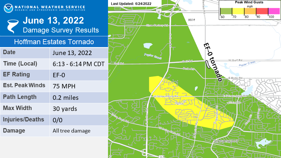
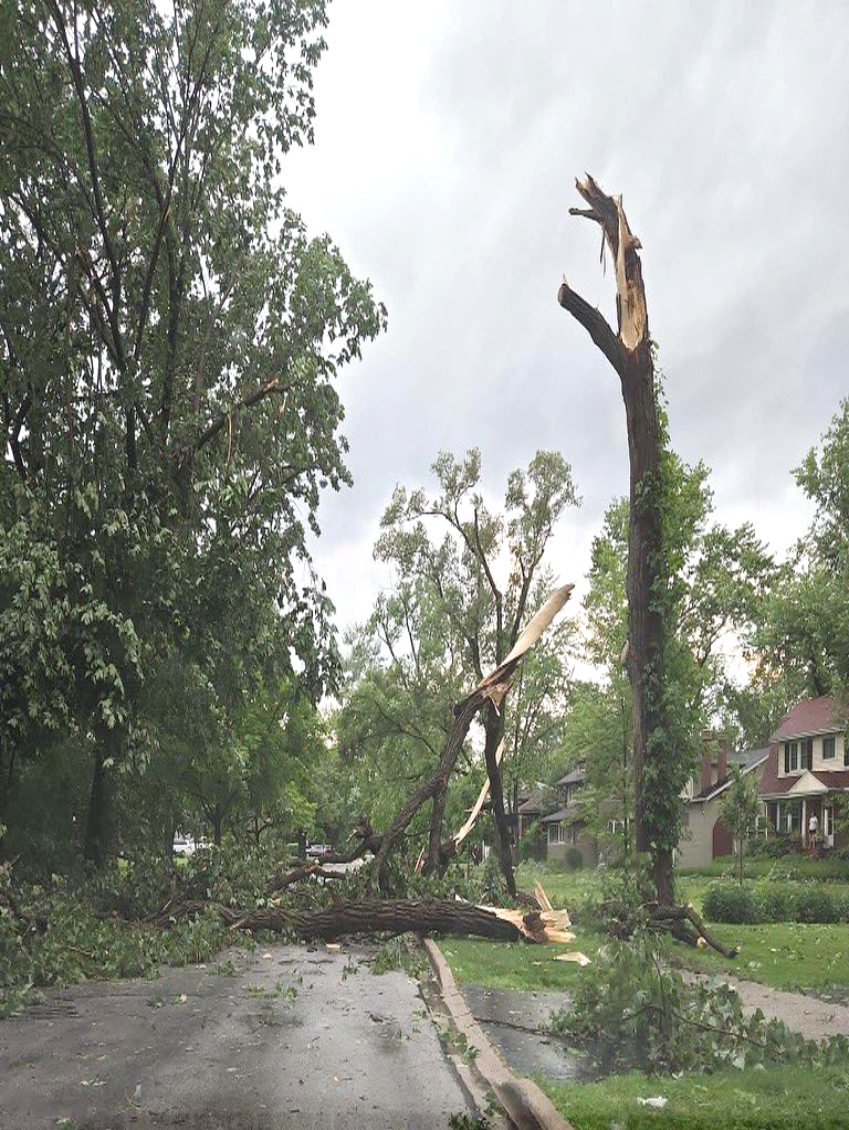
Tornado #1: Hoffman Estates EF-0 Tornado and Streamwood Straight-Line Winds:
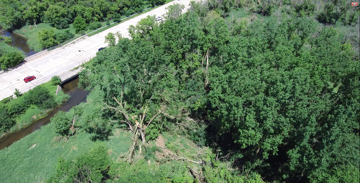
Summary: Based on drone video footage and radar data from KLOT, TORD, and TMDW, it was determined that a brief EF-0 tornado touched down near the intersection of Golf Rd. and Bartlett Rd. in the Arthur L. Janura Forest Preserve in Hoffman Estates. Damage along the tornado's brief path was entirely confined to trees. In addition, an NWS damage survey determined that widespread tree damage across Streamwood occurred due to strong straight-line winds of up to 75 mph. These winds were associated with a rear flank downdraft that wrapped around the tornadic circulation within the parent supercell thunderstorm. |
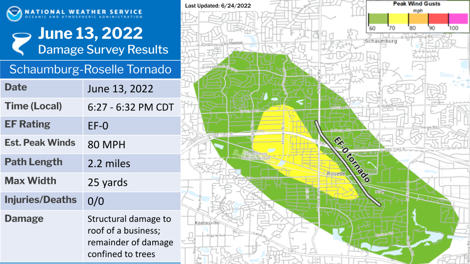
Tornado #2: Schaumburg-Roselle EF-0 Tornado and Straight-Line Winds:
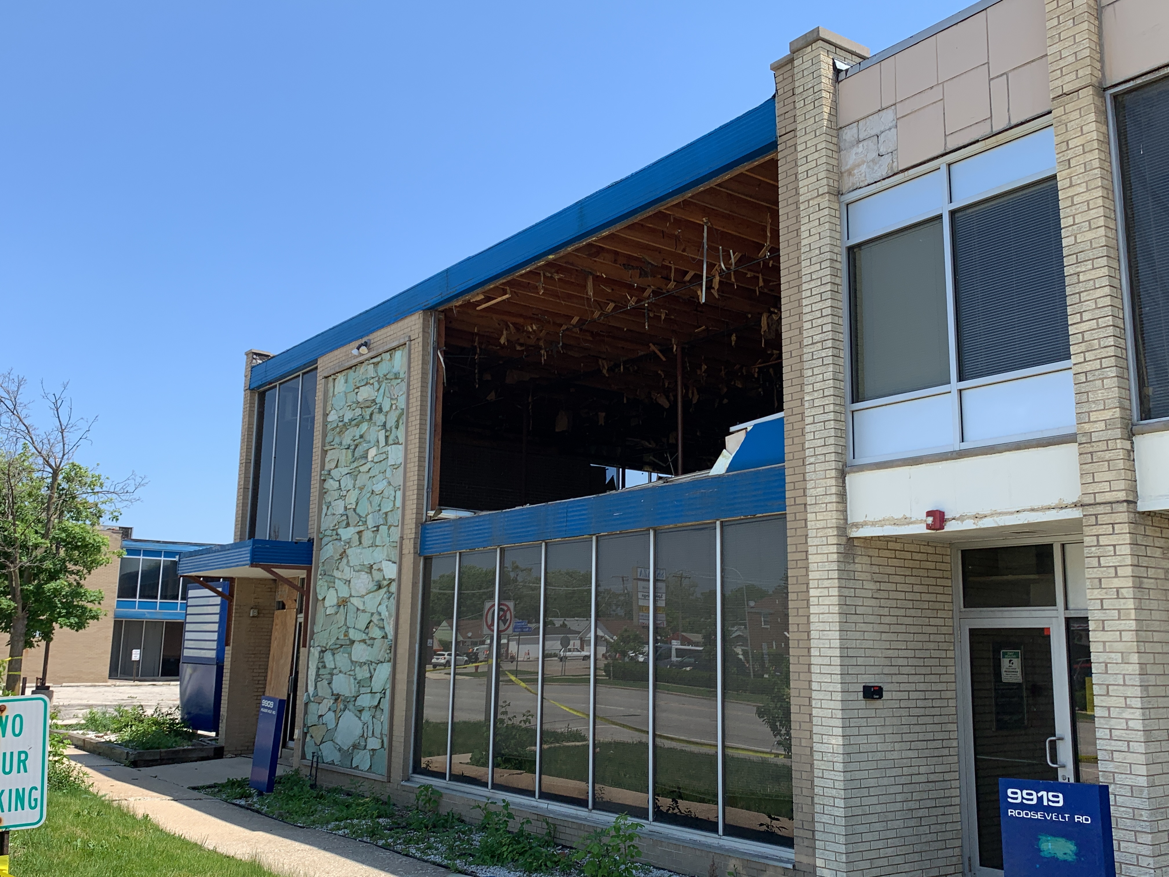
Summary: An NWS damage survey determined that a brief tornado touched down in unincorporated Schaumburg, crossed the Elgin-O`Hare Expressway into Roselle, and lifted just prior to entering Medinah. Damage was sporadic along the path of the tornado and consisted of part of the roof of a business getting peeled back in two different directions with the rest of the damage being confined to trees. Just west of the track of the tornado, a broader swath of straight-line wind damage associated with a rear flank downdraft wrapping around the tornadic circulation was observed. These winds were estimated to be as strong as 75 mph and flipped over a small plane at Schaumburg Regional Airport in addition to causing widespread tree damage on the far southern side of Schaumburg and through much of Roselle. |
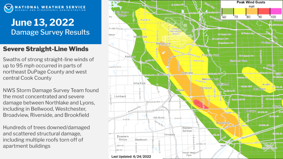
Northeast DuPage County/West Central Cook County Straight-Line Winds:
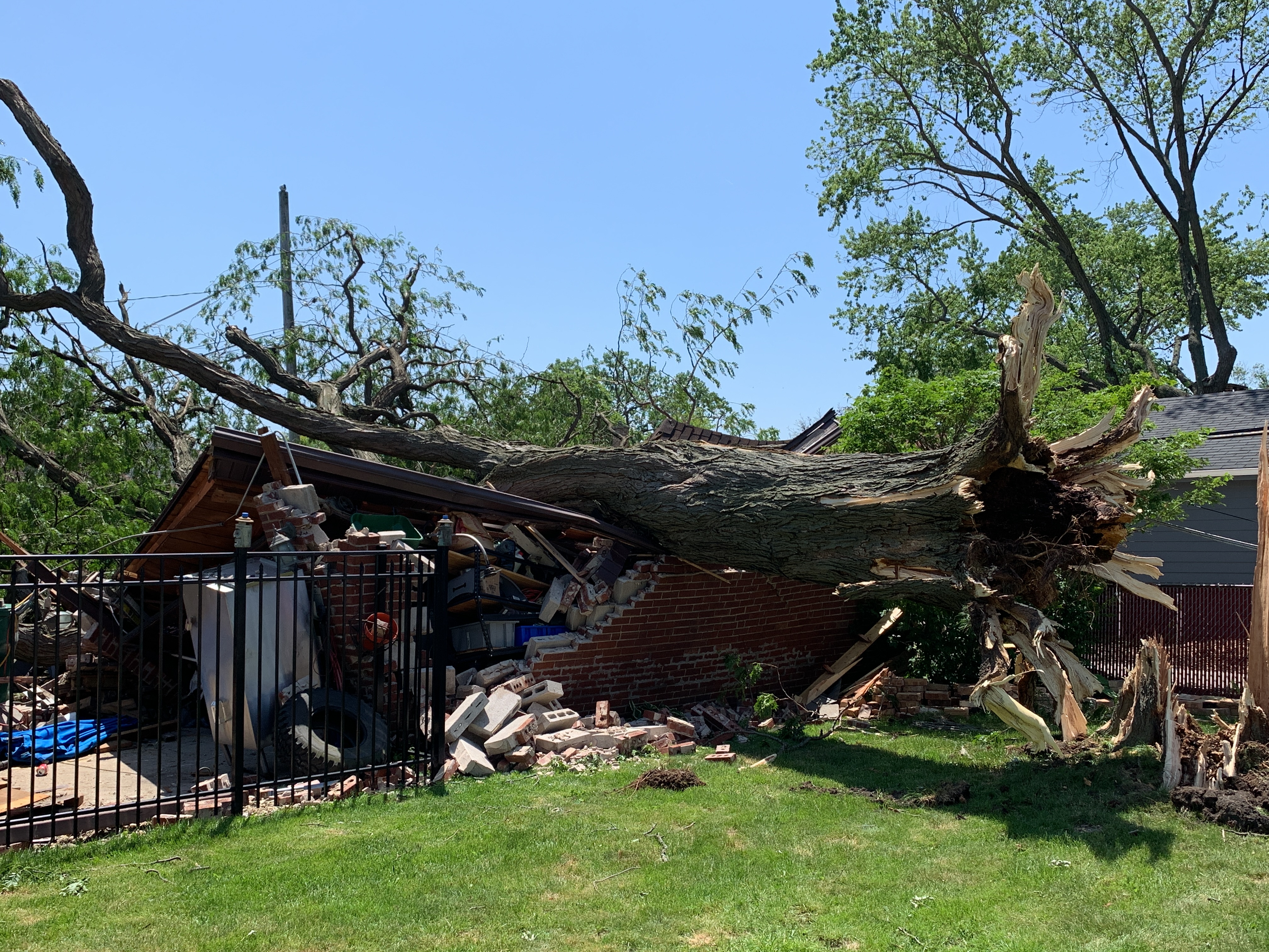
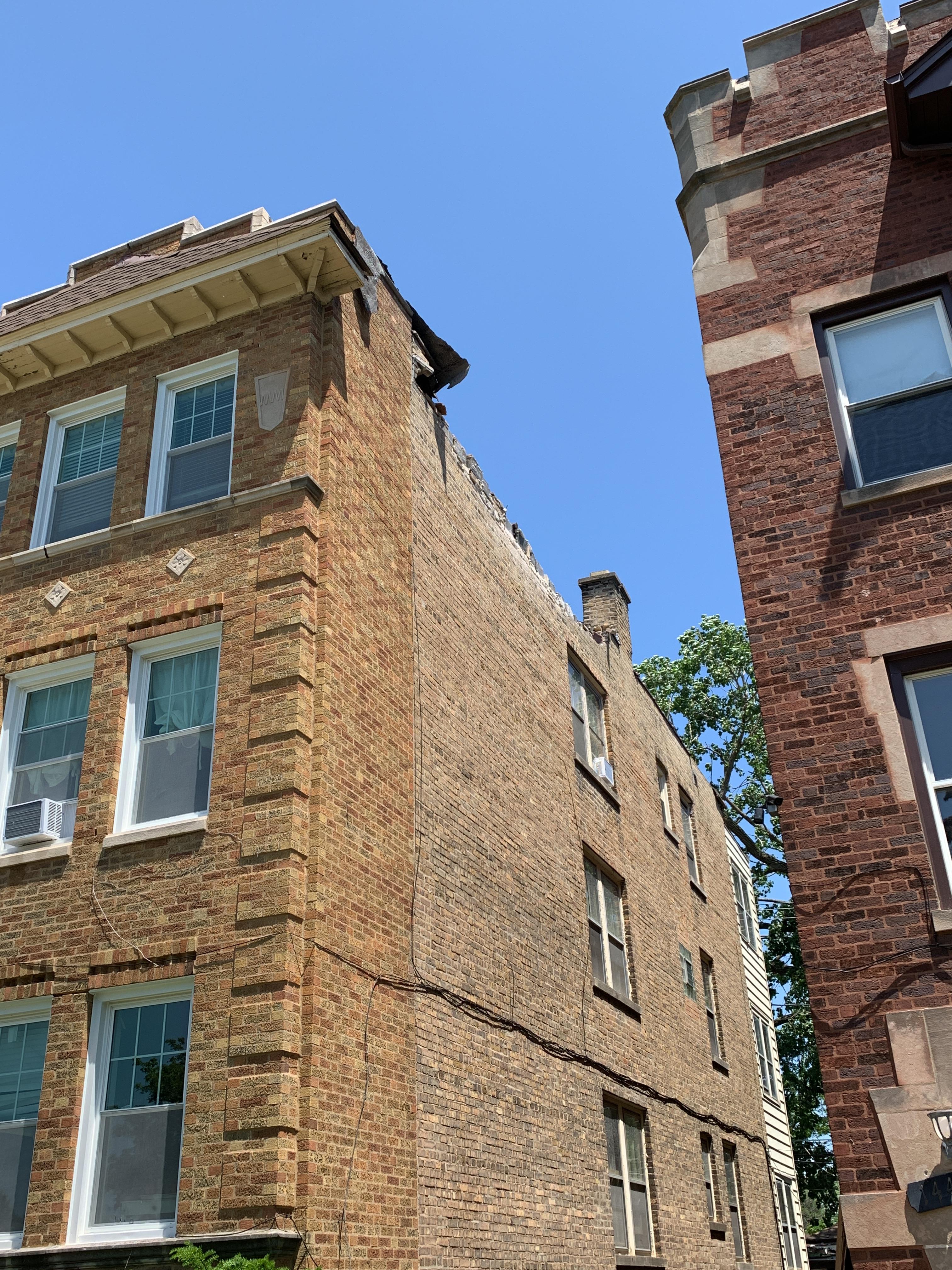
Summary: Between an NWS damage survey and information provided by local emergency management agencies, other government officials, and trained weather spotters, it was determined that damage to trees, utility poles, and structures observed across a large portion of west central Cook County was caused by a swath of strong straight-line winds. An approximately 18 to 19-mile long stretch of widespread 70+ mph winds likely occurred between Elk Grove Village and Midway Airport, with widespread 80+ mph winds likely experienced within a roughly 13-mile long corridor from O`Hare Airport (where an 84 mph wind gust was observed) through the Lyons and Forest View area. Widespread tree damage was noted in this region, including in the suburbs of Bensenville, Northlake, Stone Park, Bellwood, Westchester, Broadview, La Grange Park, Brookfield, Riverside, Lyons, Stickney, and Forest View, among other nearby locations. A localized corridor of estimated 90-95 mph winds was determined to have occurred in parts of Westchester and Broadview, with the former location having roofs peeled off of two neighboring apartment complexes and multiple windows blown out at an office building. An isolated 95 mph wind gust was believed to have occurred outside of this localized corridor in Bellwood, where an apartment complex had its roof peeled off, resulting in two injuries. |
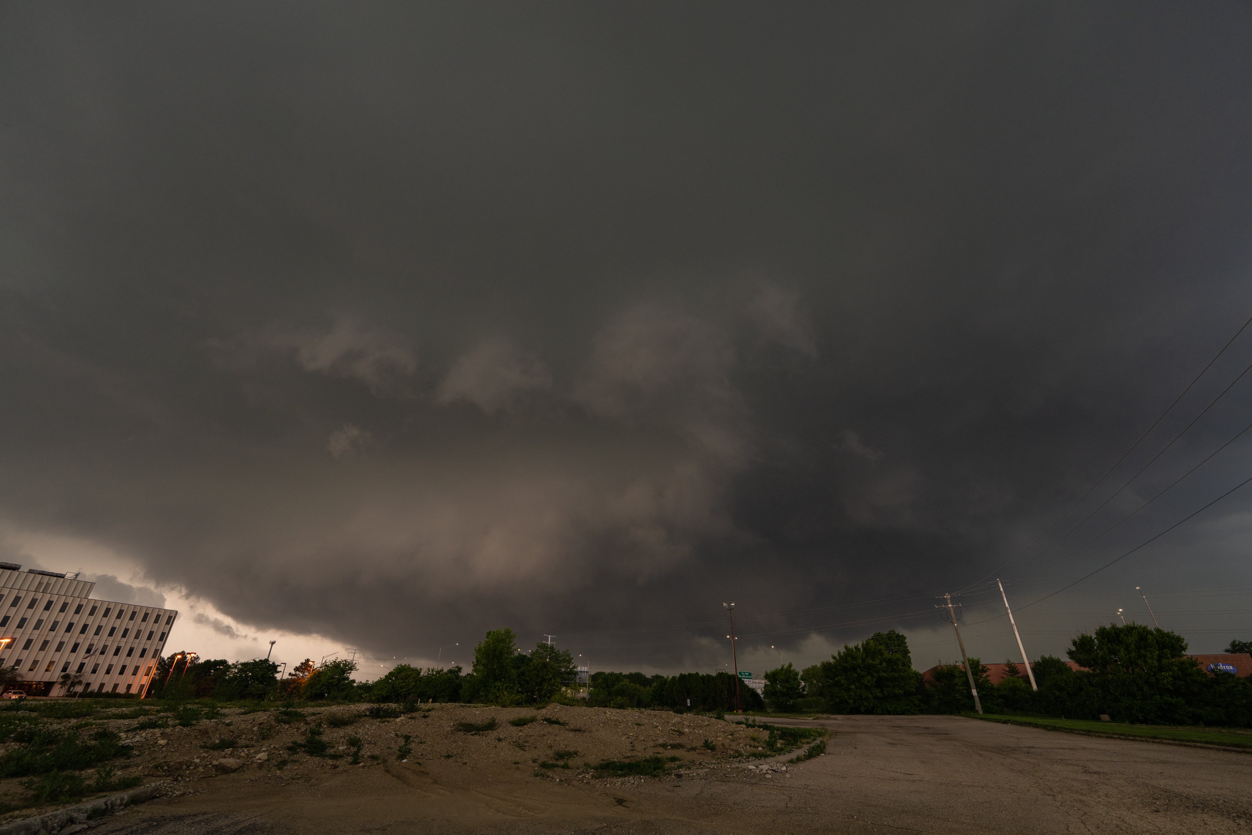
Photos
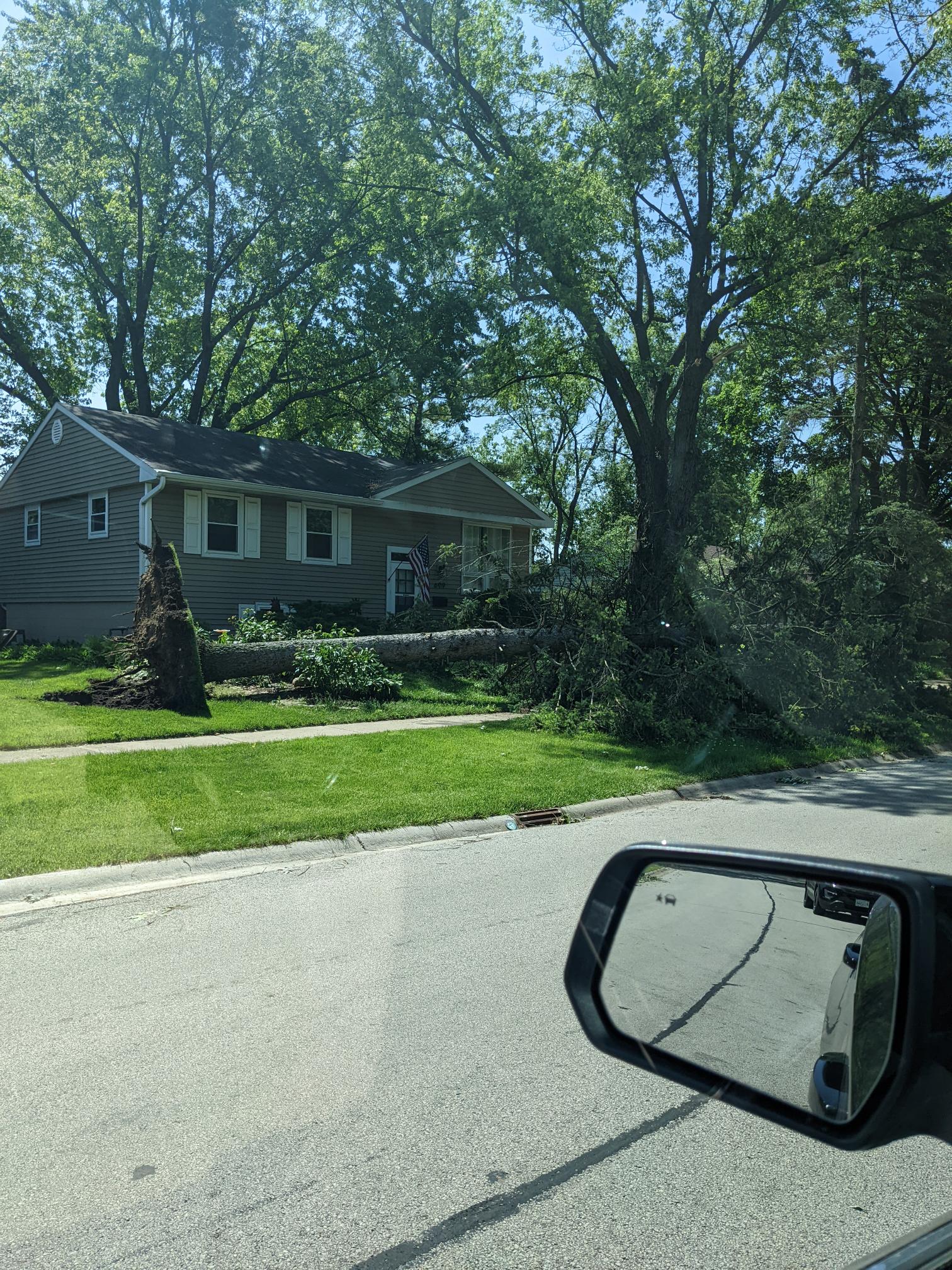 |
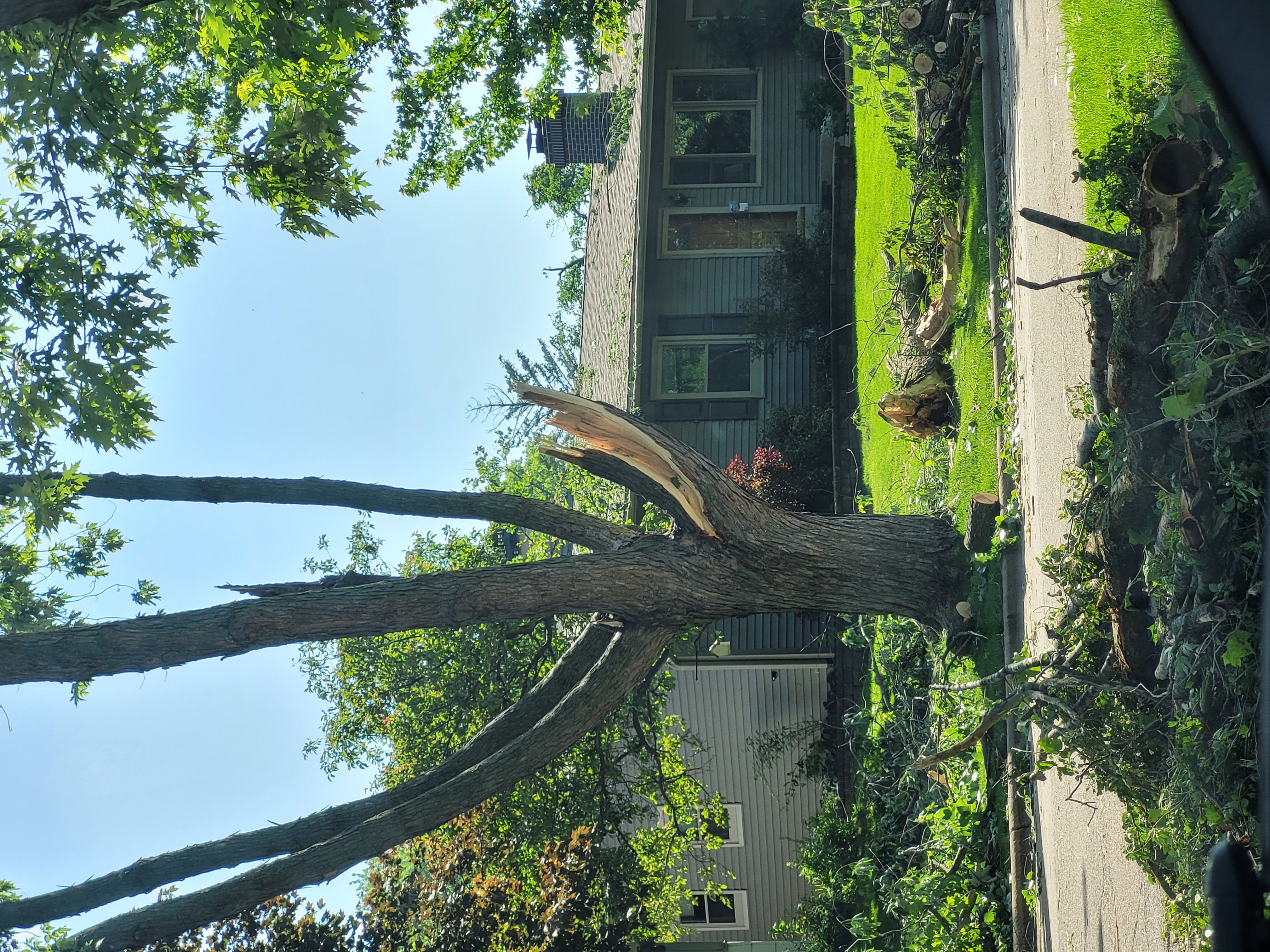 |
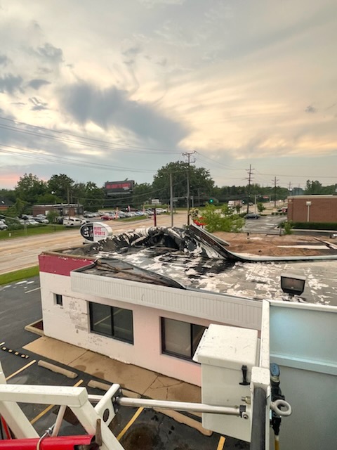 |
| Wind damage in Streamwood (courtesy of Tim Stencil) | Wind damage in Streamwood (courtesy of Mick Fleming) | Tornado damage in Roselle (courtesy of the Roselle Fire Department) |
|
|
|
|
| Tornado damage in the Arthur L. Janura Forest Preserve in Hoffman Estates (drone footage courtesy of Joe Pudlik Jr.) | Wind damage in Westchester (NWS storm survey) | Wind damage in Westchester (NWS storm survey) |
 |
 |
|
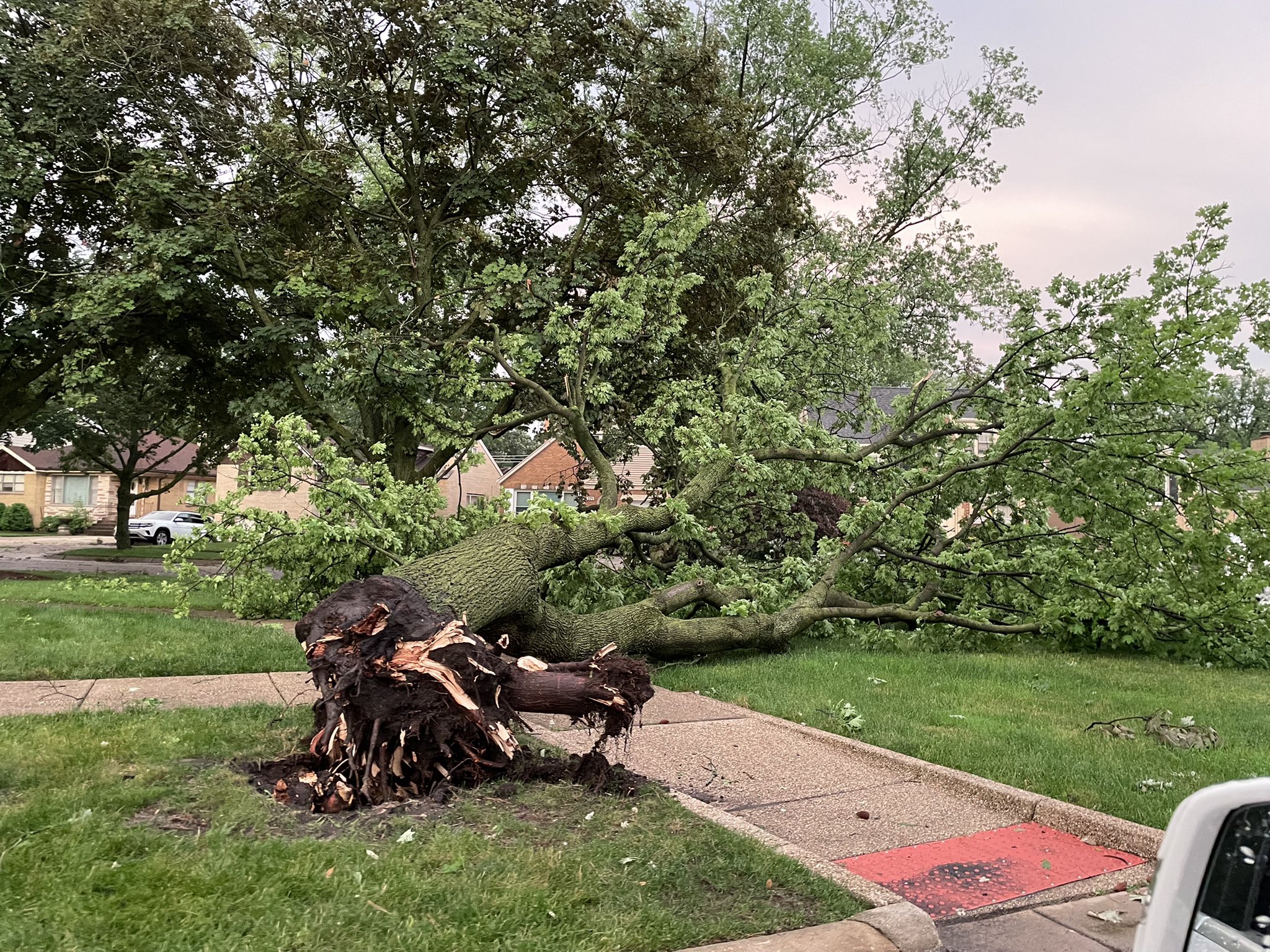
| Wind damage in Westchester (NWS storm survey) | Wind damage in Berwyn (courtesy of Steve Richter) | Wind damage in Riverside (courtesy of Jeff Bartl) |
|
|
|
|
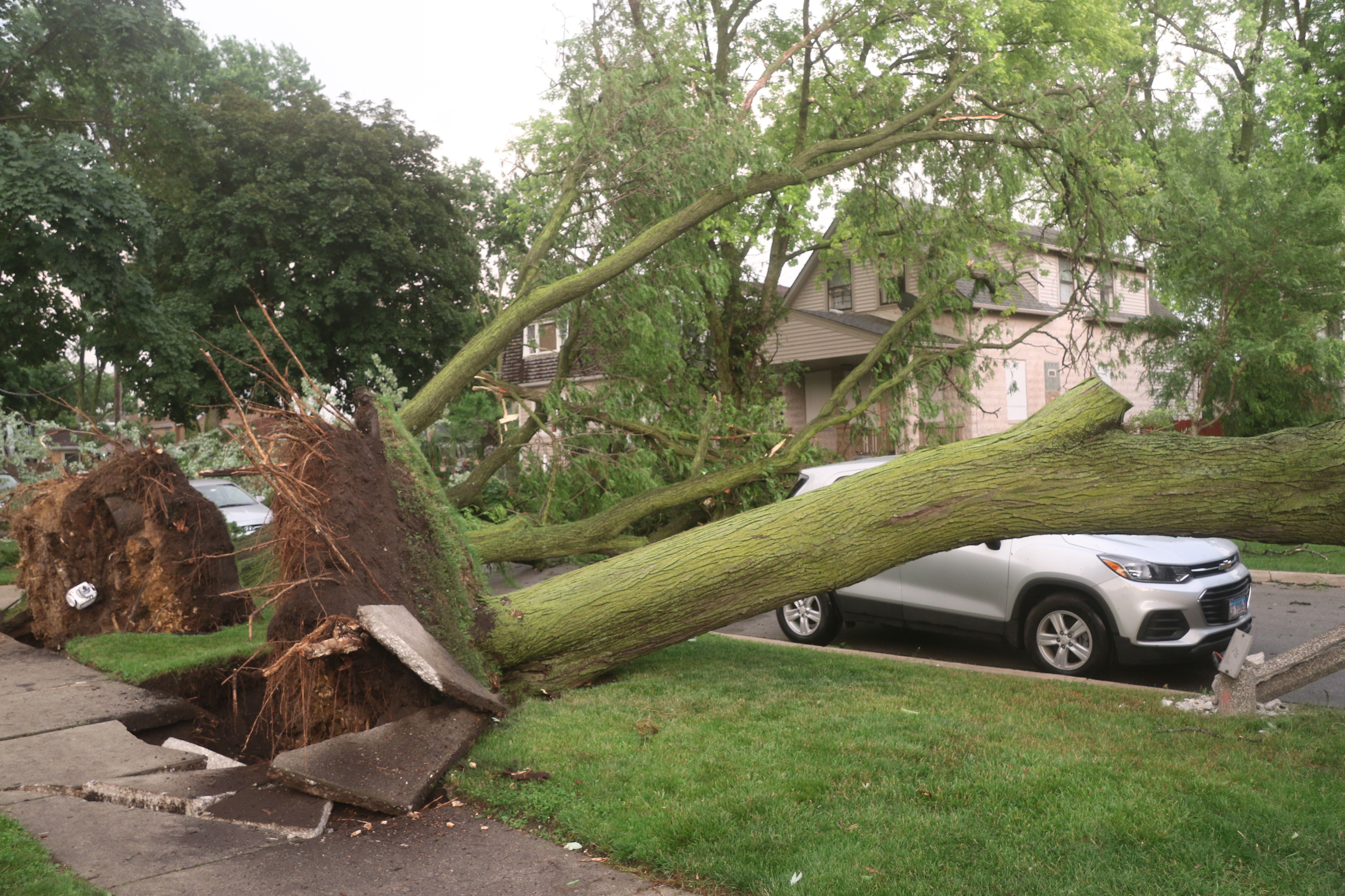
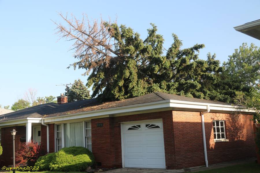
| Wind damage in Riverside (courtesy of Jeff Bartl) | Wind damage in Lyons (courtesy of William Ruting) | Wind damage in Lyons (courtesy of William Ruting) |
|
|
|
|
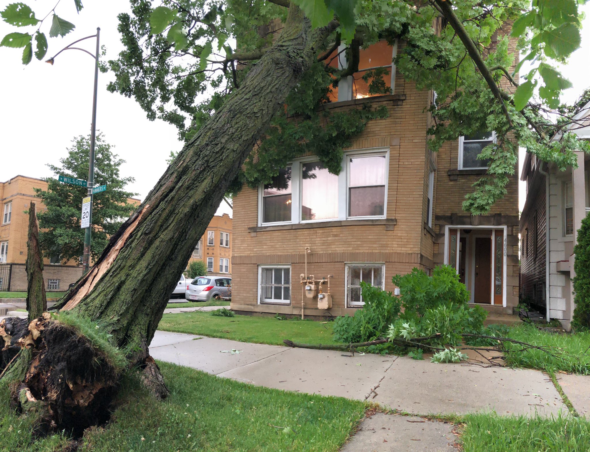
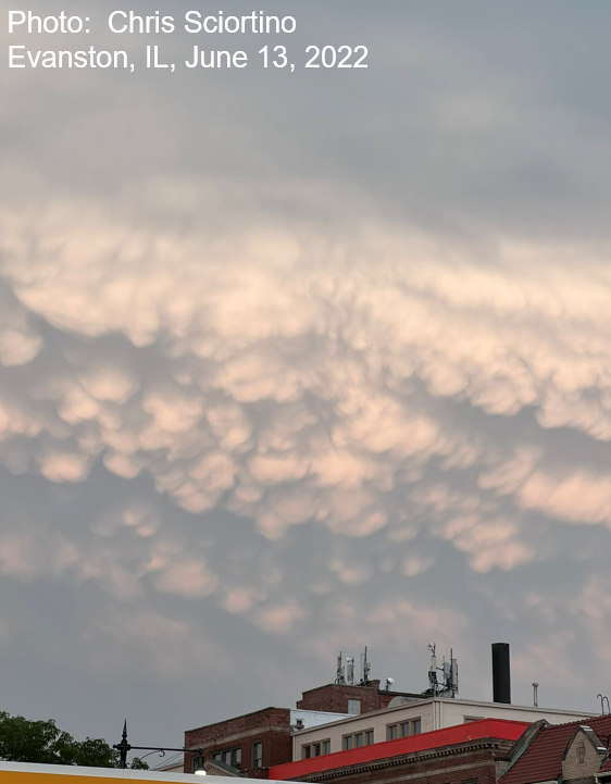
| Wind damage in the Albany Park neighborhood of Chicago (courtesy of @MonteyTheDog) | Mammatus clouds in Evanston (courtesy of Chris Sciortino) | View of the supercell from the southwest (courtesy of Alan M) |
|
|
|
|
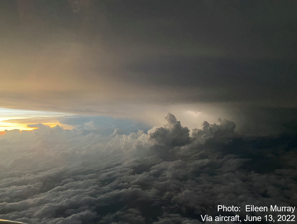
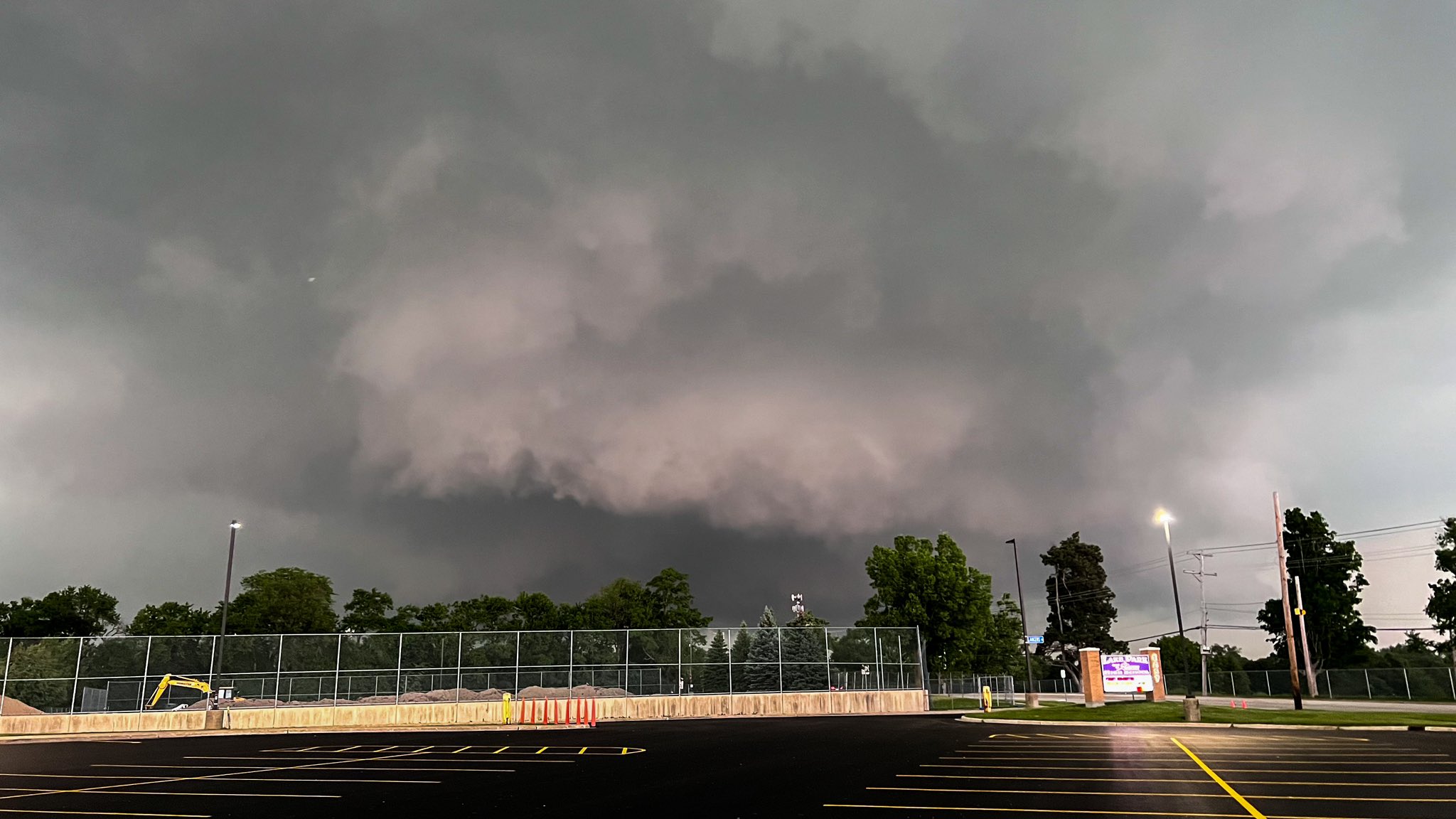
| Photo of the supercell taken on an aircraft (courtesy of Eileen Murray) | Photo of a wall cloud taken in Elgin (courtesy of Matt Zuro) | Photo of a wall cloud taken in Roselle a few minutes before a tornado touched down (courtesy of Landon Moeller) |
Environment
Surface:
 |
 |
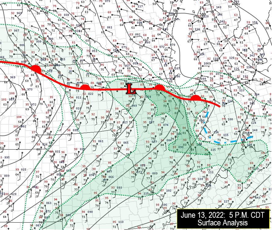 |
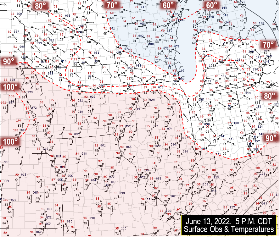
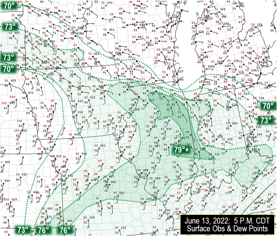
| June 13, 2022 5 P.M. Surface Temperatures | June 13, 2022 5 P.M. Surface Dew Points | June 13, 2022 5 P.M. Composite Surface Analysis. This highlights a strong warm front that had lifted slowly north across the area, and the likely presence of a mesoscale low pressure area that was entering northwest Illinois. |
Upper Air:
 |
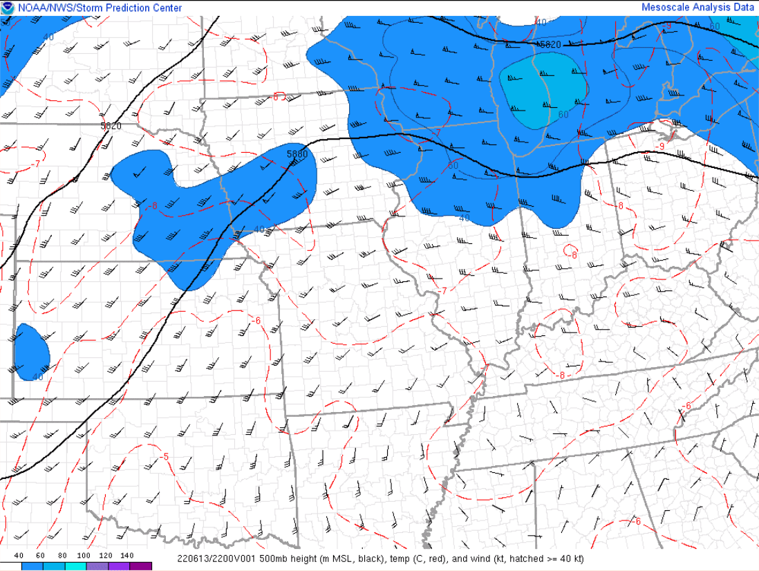 |
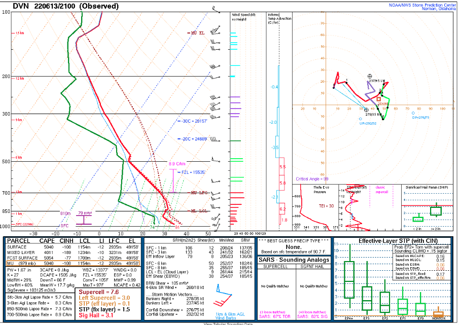
| June 13, 2022 4 P.M. NWS Davenport, IA Weather Balloon Data (Sounding). This depicted the air mass to the immediate south of the warm front and shows extreme potential instability, although still an atmospheric cap in place in this area (different along the front where forcing for updrafts was greater). The weather balloon also sampled 0-6 km deep layer shear of 50 kt, sufficient for supercell storms. | June 13, 2022 5 P.M. 500 mb (~18,000 ft) Analysis. The 50 kt+ flow at 500 mb is potent for the summer season, especially in convective scenarios. This boosted the deep layer shear and potential for thunderstorm organization. |
Severe Weather Parameters:
 |
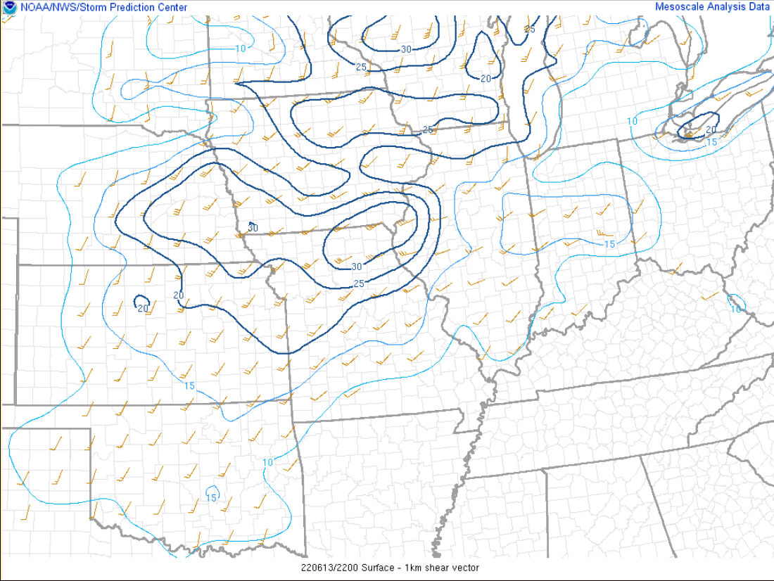 |
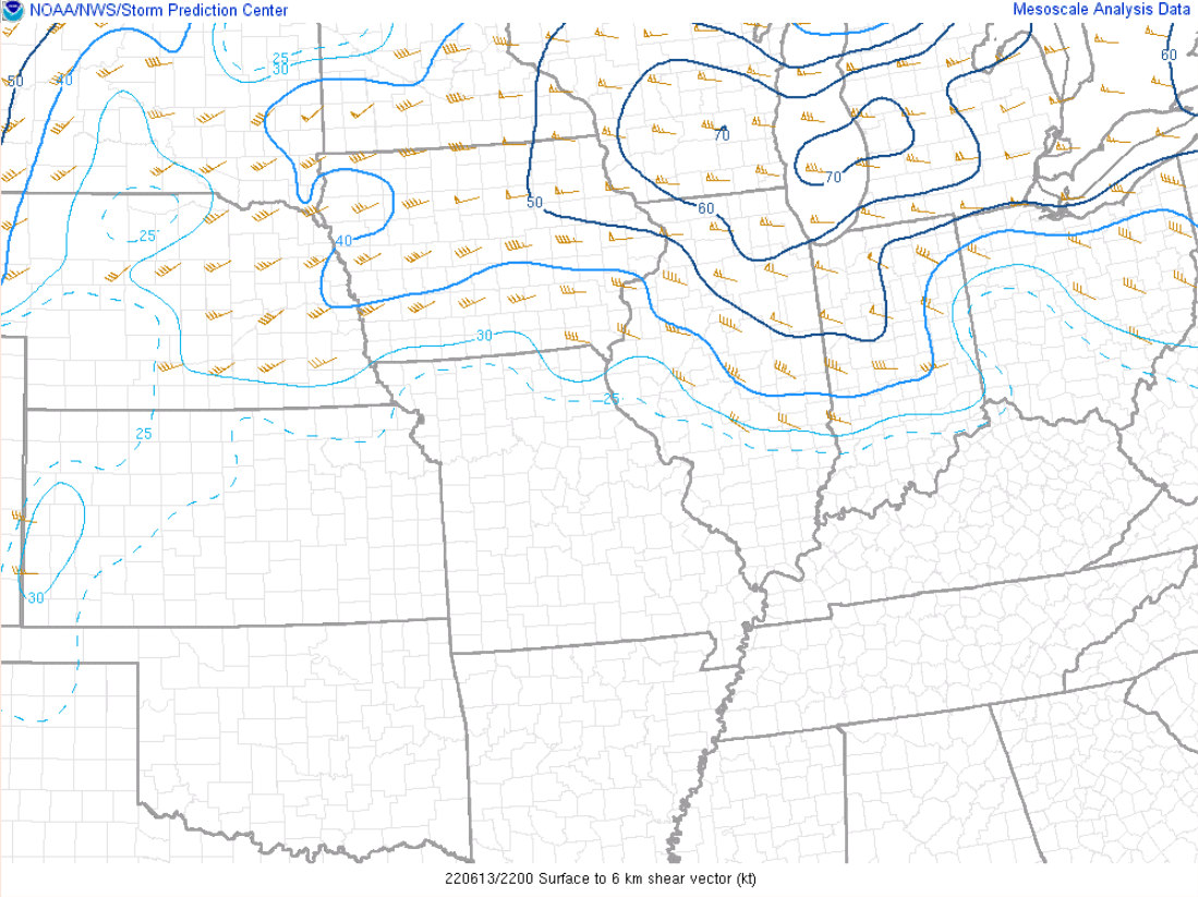
| June 13, 2022 5 P.M. 0-6 km Shear Analysis. Values in excess of 35 kt support supercells and just overall thunderstorm organization. | June 13, 2022 5 P.M. 0-1 km Shear Analysis. Values in excess of 15-20 kt support low-level rotation in thunderstorms within unstable air masses, and also support cold pool sustainability. |
 |
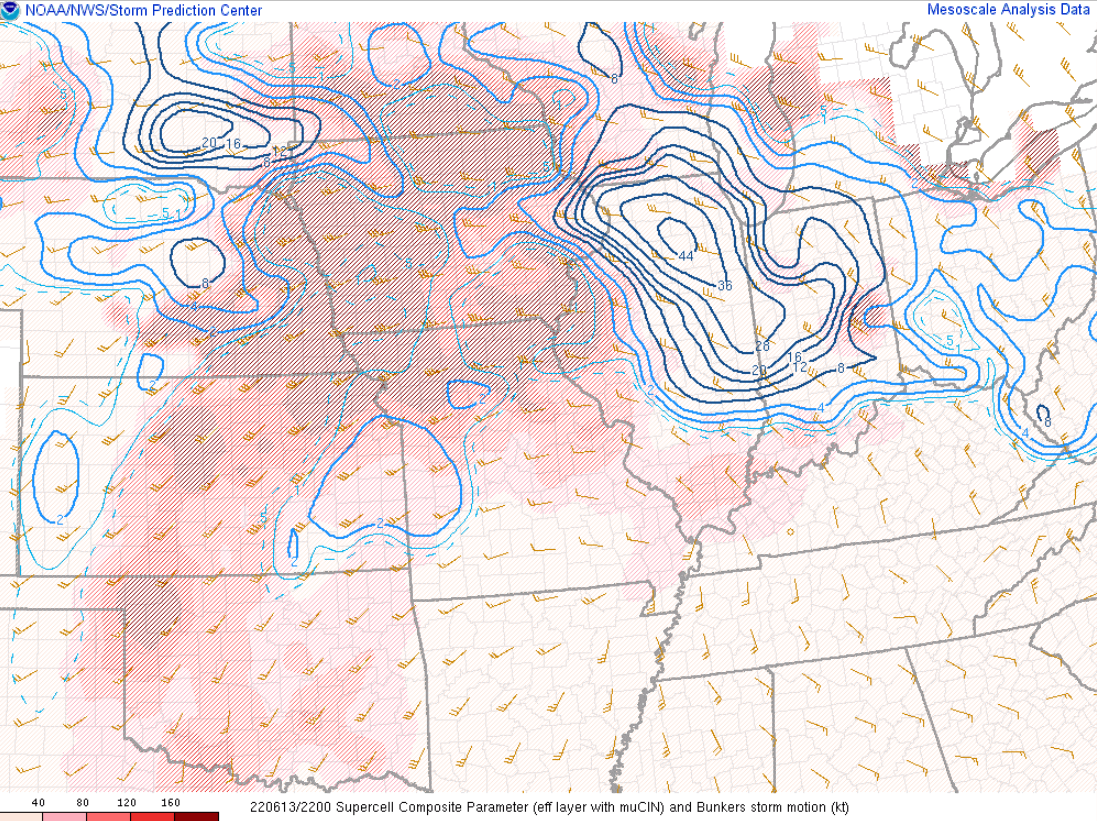 |
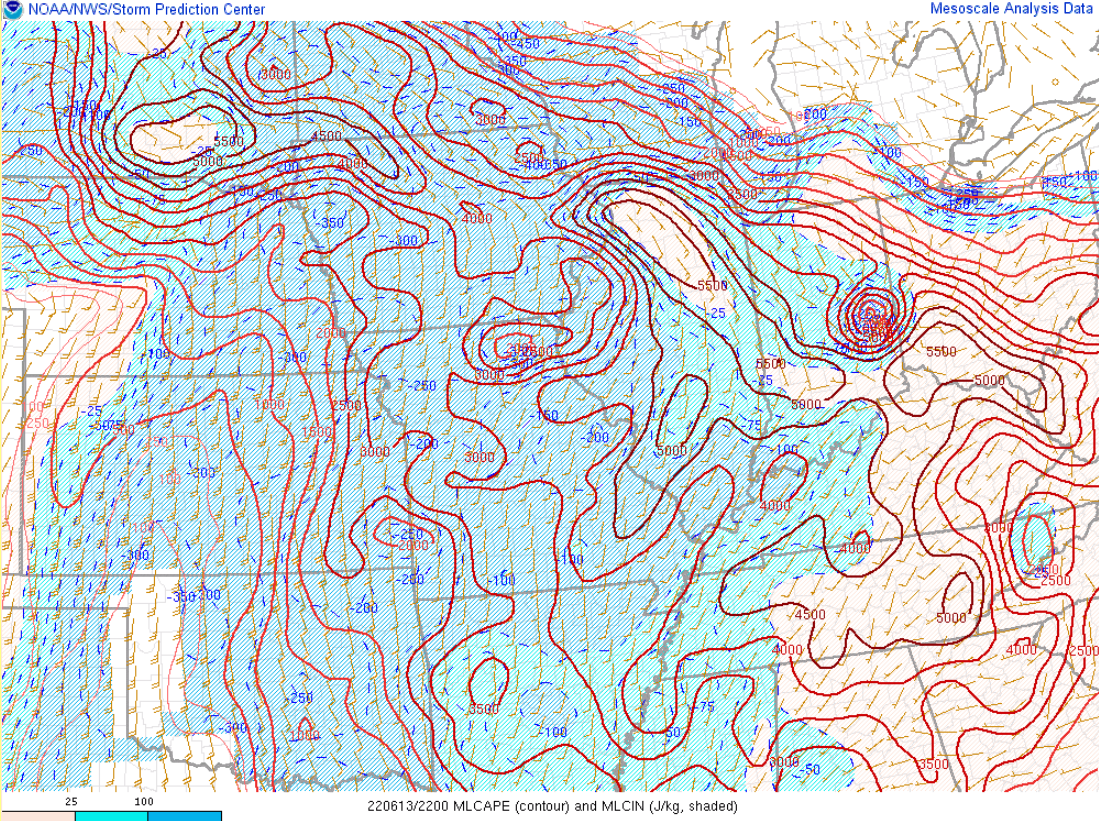
| June 13, 2022 5 P.M. Mixed-Layer CAPE (Instability). Extreme values are over 4,000 J/kg, and can result in explosive thunderstorm development, such as seen this afternoon along the warm front in northeast Illinois. | June 13, 2022 5 P.M. Supercell Parameter. This composite parameter highlights values with strong instability, shear, helicity, and little to no capping. Values of 2 can be favorable for supercells where mature storms actually develop. Extremely high values resided over Illinois, not surprisingly given especially the instability, but in tandem with the shear. |
Observed Rainfall
Public Information Statement
National Weather Service Chicago IL
0228 PM CDT Tue Jun 14 2022

...Observed Rainfall from Monday June 13...

   The following are rain amounts for the previous 24-hours
   as measured in the morning by NWS Cooperative Observers
   and CoCoRaHS observers.
   Observations are usually taken between 6 AND 8 AM.

   24-hour rainfall amounts
       for Tuesday(06/14/22)...


Illinois                                       Rain
  Location (County):                           fall (inches)

  Algonquin 1N (McHenry).......................1.42
  Schaumburg 2E (Cook).........................1.36
  Mount Prospect 3NE (Cook)....................1.07
  Palatine 1E (Cook)...........................0.93
  Harwood Heights (Cook).......................0.90
  Ohare Airport (Cook).........................0.88
  Elk Grove Village 2WSW (Cook)................0.87
  Lake Zurich (Lake)...........................0.86
  Huntley (McHenry)............................0.85
  Wheeling (Cook)..............................0.82
  Crystal Lake 1WSW (McHenry)..................0.75
  Lake Zurich 1N (Lake)........................0.74
  Chicago 6ESE (Cook)..........................0.73
  Elk Grove Village 1ESE (Cook)................0.73
  Oak Park 1SW (Cook)..........................0.72
  Cary (McHenry)...............................0.72
  Rogers Park 2SW (Cook).......................0.71
  Lincolnwood 2E (Cook)........................0.71
  Lincolnwood 3E (Cook)........................0.70
  Park Ridge 1WNW (Cook).......................0.68
  Buffalo Grove 2N (Lake)......................0.65
  Hoffman Estates 2SE (Cook)...................0.62
  Oak Park 1NNE (Cook).........................0.62
  Barrington (Lake)............................0.59
  Riverwoods (Lake)............................0.59
  Elgin (Kane).................................0.40
  Bannockburn (Lake)...........................0.40
  Mundelein (Lake).............................0.39
  Hoffman Estates 5W (Cook)....................0.38
  Highwood 1S (Lake)...........................0.35
  Elgin 2WNW (Kane)............................0.34
  Lincolnshire 1N (Lake).......................0.34
  Capron (Boone)...............................0.28
  Elmhurst 1ESE (Du Page)......................0.27
  Mundelein (Lake).............................0.25
  Libertyville 2ESE (Lake).....................0.17
  Lake Forest 2NNE (Lake)......................0.15
  Mundelein 2WNW (Lake)........................0.15
  Bolingbrook 3NE (Du Page)....................0.14
  Bull Valley 2WNW (McHenry)...................0.14
  Lake Bluff 1W (Lake).........................0.13
  McHenry (Stratton Lock & Dam) (McHenry)......0.12
  Woodstock 5nw (McHenry)......................0.12
  Homer Glen 1ENE (Will).......................0.09
  Woodstock 4SW (McHenry)......................0.07
  Elmhurst 2SE (Du Page).......................0.05
  Cissna Park 1S (Iroquois)....................0.05
  Hebron (McHenry).............................0.04
  Wonder Lake 1NE (McHenry)....................0.04
  Midway (Cook)................................0.04
  Elgin 2W (Kane)..............................0.02
  Lake Villa 2WSW (Lake).......................0.02
  Midlothian (Cook)............................0.01
  Winthrop Harbor 1SSW (Lake)..................0.01
  Monee (Will).................................0.01
  Aurora (Kane)...............................TRACE
  Batavia (Kane)..............................TRACE
  Bourbonnais (Kankakee)......................TRACE
  Dwight (Livingston).........................TRACE
  DeKalb (De Kalb)............................TRACE
  West Chicago (Du Page)......................TRACE
  Genoa (De Kalb).............................TRACE
  Oak Lawn 2SE (Cook).........................TRACE
  Oak Lawn (Cook).............................TRACE
  Homewood (Cook).............................TRACE
  Lisle (Du Page).............................TRACE
  Lisle 1SE (Du Page).........................TRACE
  Ashkum 5.6E (Iroquois)......................TRACE
  Montgomery 1SSE (Kendall)...................TRACE
  Batavia 2WNW (Kane).........................TRACE
  Sugar Grove 1ENE (Kane).....................TRACE
  St. Charles (Kane)..........................TRACE
  Winthrop Harbor (Lake)......................TRACE
  Zion (Lake).................................TRACE
  Ottawa 1NW (La Salle).......................TRACE
  Peru 1ENE (La Salle)........................TRACE
  New Lenox 2SE (Will)........................TRACE
  New Lenox 3E (Will).........................TRACE
  New Millford 3W (Winnebago).................TRACE
  Lansing (Cook)..............................TRACE
  Romeoville (Will)...........................TRACE
  Midway Coop (Cook)..........................TRACE
  Rockford (Winnebago)........................TRACE
  St Anne (Kankakee)..........................TRACE
  Waukegan (Lake).............................TRACE

Indiana                                        Rain
  Location (County):                           fall (inches)

  Valparaiso 1SE (Porter)......................0.55
  Valparaiso Airport (Porter)..................0.47
  Gary 5ENE (Lake).............................0.44
  Valparaiso 1NNW (Porter).....................0.41
  Valparaiso 2N (Porter).......................0.39
  Chesterton 4E (Porter).......................0.37
  Portage 3E (Porter)..........................0.36
  Chesterton 1ENE (Porter).....................0.35
  Valparaiso 2WNW (Porter).....................0.35
  Indiana Dunes (Porter).......................0.31
  Porter 1S (Porter)...........................0.28
  Valparaiso 2WSW (Porter).....................0.19
  Kentland 2SSE (Newton).......................0.15
  Valparaiso 6SSW (Porter).....................0.15
  Remington (Jasper)...........................0.10
  Hammond 1SSW (Lake)..........................0.10
  Lakes Of The Four Seasons (Porter)...........0.02
  Crown Point (Lake)..........................TRACE
  De Motte 1NNW (Jasper)......................TRACE
  Wheatfield 4WSW (Jasper)....................TRACE
  Crown Point 1N (Lake).......................TRACE
  Schererville 1E (Lake)......................TRACE
  Griffith 1N (Lake)..........................TRACE
  Mount Ayr 2NNE (Newton).....................TRACE
  Hebron 4NE (Porter).........................TRACE
Additional Info​
 |
Media use of NWS Web News Stories is encouraged! Please acknowledge the NWS as the source of any news information accessed from this site. Additional recaps can be found on the NWS Chicago Past Events Page |
|


.png)