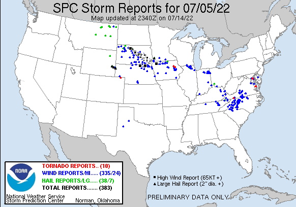
Tropical Depression Two is expected to gradually strengthen and could bring tropical storm conditions to the Florida Panhandle beginning late Monday. Areas of flash flooding will be possible through Thursday along the eastern and central Gulf Coast. Severe thunderstorms will develop and move along a cold front crossing the Upper Midwest Monday, and through the Ohio Valley/Mid-Atlantic on Tuesday. Read More >
Overview
|
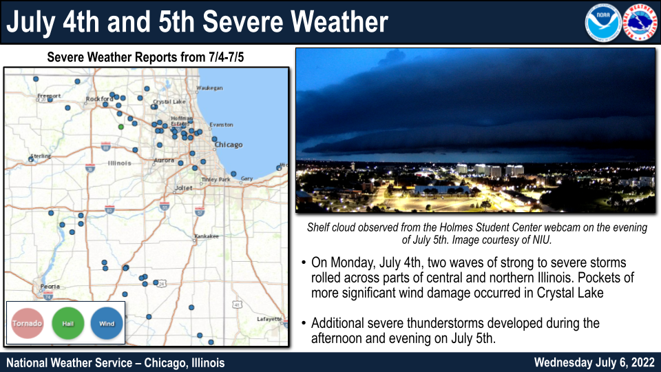
During the afternoon and evening of July 4th, two waves of strong to severe thunderstorms rolled across the region. The first wave of storms moved across parts of La Salle, Grundy, Livingston, and Ford Counties during the mid afternoon, delivering sporadic damaging wind gusts and torrential rainfall. The second wave developed during the early evening hours across far southern Wisconsin before accelerating southeastward along the I-90 corridor. These storms brought additional areas of damaging winds and heavy rainfall to the area. Localized corridors of more significant wind damage occurred in Crystal Lake and Elgin. Another round of storms developed late in the afternoon of July 5th, impacting parts of northern and northwest Illinois. These storms produced wind damage primarily in far northern Illinois and also caused minor flooding along the I-90 corridor, where over 6" of rain fell in some locations over the course of two days.
|
 |
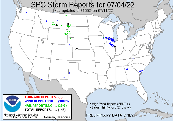
July 4th Storm Reports
 |
PRELIMINARY LOCAL STORM REPORT...SUMMARY
NATIONAL WEATHER SERVICE CHICAGO IL
716 PM CDT THU JUL 7 2022
..TIME... ...EVENT... ...CITY LOCATION... ...LAT.LON...
..DATE... ....MAG.... ..COUNTY LOCATION..ST.. ...SOURCE....
..REMARKS..
0230 PM TSTM WND DMG CEDAR POINT 41.26N 89.13W
07/04/2022 LA SALLE IL PUBLIC
TREE BRANCHES DOWNED IN CEDAR POINT. TIME
ESTIMATED BY RADAR.
0230 PM TSTM WND DMG PERU 41.33N 89.13W
07/04/2022 LA SALLE IL 911 CALL CENTER
TREE BRANCHES DOWNED IN PERU. TIME ESTIMATED
BY RADAR.
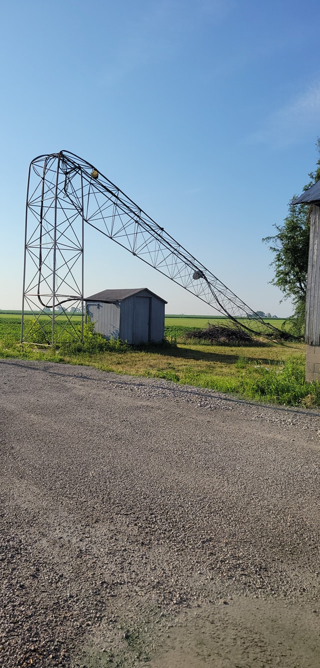
0254 PM TSTM WND DMG 4 N FLANAGAN 40.93N 88.87W
07/04/2022 LIVINGSTON IL PUBLIC
[DELAYED REPORT] REPORT OF TREES AND CORN
DOWN NEAR FLANAGAN. PICTURE OF A BENT METAL
STRUCTURE. TIME AND LOCATION ESTIMATED BASED
ON RADAR.
0259 PM HEAVY RAIN 1 SW PERU 41.32N 89.14W
07/04/2022 M3.75 INCH LA SALLE IL PUBLIC
PRIVATE WEATHER STATION RECORDS 3.75 INCHES
OF RAINFALL SINCE 1:35PM, WITH 2.81 INCHES
IN 1 HOUR.
0309 PM HEAVY RAIN OGLESBY 41.29N 89.06W
07/04/2022 M4.07 INCH LA SALLE IL PUBLIC
PRIVATE WEATHER STATION RECORDED 4.07 INCHES
SINCE 1:54PM, WITH 3.9 INCHES IN 1 HOUR
ENDING AT 2:59PM.
0335 PM TSTM WND DMG PONTIAC 40.88N 88.63W
07/04/2022 LIVINGSTON IL PUBLIC
REPORT OF UPROOTED/SPLIT TREES AS WELL AS
MULTIPLE POWER LINES DOWN IN PONTIAC. TIME
ESTIMATED BASED ON RADAR AND SOCIAL MEDIA
REPORT.
0339 PM TSTM WND DMG 3 SW WINNEBAGO 42.23N 89.28W
07/04/2022 WINNEBAGO IL TRAINED SPOTTER
SPOTTER REPORTS PART OF A BARN ROOF WAS
BLOWN OFF AND SEVERAL TWIGS BLOWN AROUND.
TIME ESTIMATED FROM RADAR.
0341 PM TSTM WND DMG PONTIAC 40.88N 88.63W
07/04/2022 LIVINGSTON IL BROADCAST MEDIA
MEDIA RELAYED REPORT OF SEVERAL TREE
BRANCHES DOWN, ONE OF WHICH FELL ON A CAR.
0343 PM TSTM WND DMG 1 NE PONTIAC 40.89N 88.62W
07/04/2022 LIVINGSTON IL BROADCAST MEDIA
REPORT RELAYED BY MEDIA OF SEVERAL TREES
DOWN ALONG EAST INDIANA AVE.
0400 PM TSTM WND DMG 4 N FORREST 40.81N 88.41W
07/04/2022 LIVINGSTON IL PUBLIC
HIGH TENSILE FENCE DESTROYED, NUMEROUS TREES
BLOWN DOWN, AND SEVERAL WINDOWS BLOWN IN ON
OUTBUILDINGS. MACHINE SHED DESTROYED.
REPORTED RELAYED VIA SOCIAL MEDIA.
0401 PM TSTM WND GST FORREST 40.75N 88.41W
07/04/2022 E60 MPH LIVINGSTON IL TRAINED SPOTTER
SEVERAL SPOTTER REPORTS OF ESTIMATED 60 MPH
WIND GUSTS AND CORN BLOWN OVER.
0406 PM TSTM WND DMG FLANAGAN 40.88N 88.86W
07/04/2022 LIVINGSTON IL BROADCAST MEDIA
REPORT OF TREE LIMBS DOWN RELAYED BY MEDIA.
0422 PM TSTM WND DMG 4 NNW FORREST 40.80N 88.45W
07/04/2022 LIVINGSTON IL PUBLIC
MEDIA REPORTS SEVERAL POLES DOWN AND A BARN
COLLAPSED.
0426 PM TSTM WND DMG CHATSWORTH 40.76N 88.29W
07/04/2022 LIVINGSTON IL PUBLIC
PICTURE OF LARGE TREE DOWN RELAYED VIA
SOCIAL MEDIA. TREE DOES APPEAR TO BE
UNHEALTHY.
0500 PM HEAVY RAIN 1 SE CORNELL 40.98N 88.72W
07/04/2022 E4.43 INCH LIVINGSTON IL PUBLIC
PRIVATE WEATHER STATION RECORDED 4.43 INCHES
OF RAINFALL SINCE 2:45PM, 4.36 INCHES IN 75
MINUTES ENDING AT 4:00PM.
0510 PM TSTM WND DMG 1 S CISSNA PARK 40.55N 87.89W
07/04/2022 IROQUOIS IL PUBLIC
PHOTO SHARED VIA SOCIAL MEDIA SHOWS
FLATTENED CORN SOUTH OF CISSNA PARK. TIME
ESTIMATED BY RADAR.
0515 PM TSTM WND DMG 3 WSW ELBURN 41.88N 88.52W
07/04/2022 KANE IL PUBLIC
CORRECTS PREVIOUS REPORT FROM 3 WSW ELBURN.
REPORTS RECEIVED OF MULTIPLE LARGE POWER
POLES SNAPPED ALONG KESLINGER ROAD NEAR
DAUBERMAN ROAD. POLES SNAPPED FROM NORTH TO
SOUTH. ALSO DAMAGE TO THE ROOF OF KANELAND
HIGH SCHOOL. TIME ESTIMATED BY RADAR.
0515 PM HEAVY RAIN CHATSWORTH 40.75N 88.29W
07/04/2022 M3.00 INCH LIVINGSTON IL CO-OP OBSERVER
NWS COOP OBSERVER REPORTS 3 INCHES OF
RAINFALL IN ABOUT 1 HOUR IN CHATSWORTH.
0523 PM TSTM WND DMG GIBSON CITY 40.47N 88.37W
07/04/2022 FORD IL BROADCAST MEDIA
REPORT OF TREE DOWNED ONTO POWER LINE IN
GIBSON CITY. RELAYED VIA BROADCAST MEDIA.
TIME ESTIMATED BY RADAR.
0526 PM FLOOD BUCKLEY 40.60N 88.04W
07/04/2022 IROQUOIS IL PUBLIC
PHOTO SHARED TO SOCIAL MEDIA SHOWS MINOR
STREET FLOODING NEAR FIRST STREET AND MAIN
STREET IN BUCKLEY.
0544 PM TSTM WND DMG 2 ESE NORTH AURORA 41.79N 88.29W
07/04/2022 KANE IL PUBLIC
DELAYED REPORT. TWO LARGE TREES DOWN IN THE
MARYWOOD AREA OF UNINCORPORATED AURORA. TIME
ESTIMATED FROM RADAR.
0545 PM TSTM WND DMG BUCKLEY 40.60N 88.04W
07/04/2022 IROQUOIS IL PUBLIC
PHOTOS SHARED VIA SOCIAL MEDIA SHOW NUMEROUS
SMALL BRANCHES DOWNED IN MULTIPLE LOCATIONS
ACROSS BUCKLEY. SOME BRANCHES AT LEAST A
COUPLE INCHES IN DIAMETER.
1030 PM TSTM WND GST 1 SSW HARVARD 42.41N 88.62W
07/04/2022 M68 MPH MCHENRY IL BROADCAST MEDIA
WEATHER STATION AT CROSBY ELEMENTARY SCHOOL
RECORDED 68MPH GUST. TIME ESTIMATED BY
RADAR.
1050 PM TSTM WND GST 1 SSE GREENWOOD 42.39N 88.39W
07/04/2022 M64 MPH MCHENRY IL PUBLIC
PRIVATE WEATHER STATION RECORDED 64MPH WIND
GUST WEST OF WONDER LAKE. TIME ESTIMATED BY
RADAR.
1100 PM TSTM WND DMG 1 SSE CARPENTERSVILLE 42.11N 88.25W
07/04/2022 KANE IL EMERGENCY MNGR
LARGE TREE DOWN ACROSS ROAD AT WAKEFIELD AND
IL ROUTE 68. TIME APPROXIMATE FROM RADAR.
VIA HANOVER TOWNSHIP EMERGENCY MANAGEMENT.
1103 PM TSTM WND DMG CRYSTAL LAKE 42.24N 88.32W
07/04/2022 MCHENRY IL PUBLIC
[DELAYED REPORT] MULTIPLE 12 INCH DIAMETER
LIMBS DOWN. POWER LINES DOWN AND DAMAGED.
SEVERAL TREES UPROOTED. TIME ESTIMATED BASED
ON RADAR.
1104 PM TSTM WND DMG 1 E CRYSTAL LAKE 42.24N 88.30W
07/04/2022 MCHENRY IL PUBLIC
PICTURES OF NUMEROUS LARGE, MOSTLY HEALTHY
MATURE TREES, DOWNED ACROSS THE AREA,
ESPECIALLY IN THE VICINITY OF TERRA COTTA
ROAD AND EAST CRYSTAL LAKE AVENUE. TIME
ESTIMATED BASED ON RADAR.
1105 PM TSTM WND DMG 1 E CRYSTAL LAKE 42.24N 88.30W
07/04/2022 MCHENRY IL PUBLIC
MULTIPLE LARGE 1.5-2 FOOT DIAMETER TREES
SNAPPED OR UPROOTED ALONG CRYSTAL LAKE
AVENUE. TIME ESTIMATED BASED ON RADAR.
1110 PM TSTM WND DMG 3 E ELGIN 42.04N 88.23W
07/04/2022 COOK IL EMERGENCY MNGR
TEN INCH DIAMETER TREE DOWN ACROSS ROAD.
ROHRSSEN ROAD AND CARDINAL LANE. TIME
ESTIMATED FROM RADAR. VIA HANOVER TOWNSHIP
EMERGENCY MANAGEMENT.
1114 PM TSTM WND DMG FOX RIVER GROVE 42.20N 88.21W
07/04/2022 MCHENRY IL PUBLIC
PART OF SIDING AND ROOF SHINGLES BLOWN OFF A
HOUSE. ALSO TREES AND POWER LINES DOWNED IN
FOX RIVER GROVE.
1116 PM TSTM WND DMG 3 SE POPLAR GROVE 42.34N 88.78W
07/04/2022 BOONE IL LAW ENFORCEMENT
REPORT OF SEVERAL TREES DOWN NEAR
RUSSELLVILLE AND GRANGE HALL ROADS. TIME
ESTIMATED BASED ON RADAR AND TIME OF REPORT
CALL.
1118 PM TSTM WND DMG 5 N GARDEN PRAIRIE 42.32N 88.73W
07/04/2022 BOONE IL LAW ENFORCEMENT
REPORT OF TREES DOWN ON GARDEN PRAIRIE ROAD.
TIME ESTIMATED BASED ON RADAR AND CALL TIME.
1120 PM TSTM WND DMG 2 WSW SOUTH BARRINGTON 42.08N 88.19W
07/04/2022 COOK IL EMERGENCY MNGR
LARGE TREE BLOCKING ROAD. OLD SUTTON ROAD
AND IL ROUTE 72 HIGGINS ROAD. VIA HANOVER
TOWNSHIP EMERGENCY MANAGEMENT.
1124 PM TSTM WND DMG 2 SW MUNDELEIN 42.24N 88.03W
07/04/2022 LAKE IL PUBLIC
TREE DOWNED ONTO MIDLOTHIAN RD. TIME
ESTIMATED FROM RADAR.
1125 PM TSTM WND DMG 1 E GARDEN PRAIRIE 42.25N 88.71W
07/04/2022 BOONE IL BROADCAST MEDIA
PHOTO SHOWS DAMAGE TO GRAIN BINS AND
AGRICULTURAL STRUCTURES NEAR GARDEN PRAIRIE.
RELAYED VIA BROADCAST MEDIA. LOCATION
APPROXIMATE. TIME ESTIMATED BY RADAR.
1135 PM TSTM WND DMG ARLINGTON HEIGHTS 42.08N 87.98W
07/04/2022 COOK IL PUBLIC
[DELAYED REPORT] PICTURE OF A SIX INCH
DIAMETER TREE LIMB SNAPPED. TIME ESTIMATED
BASED ON RADAR.
1141 PM TSTM WND GST 2 SE WHEELING 42.12N 87.90W
07/04/2022 M46 MPH COOK IL ASOS
ASOS STATION KPWK WHEELING REPORTED 46 MPH
GUST.
1144 PM HEAVY RAIN 2 SW ROSCOE 42.39N 89.04W
07/04/2022 M3.01 INCH WINNEBAGO IL PUBLIC
PRIVATE WEATHER STATION RECORDED NEARLY
ABOUT 3 INCHES OF RAINFALL IN JUST OVER 1.5
HOURS.
1145 PM TSTM WND DMG GLENVIEW 42.08N 87.81W
07/04/2022 COOK IL PUBLIC
LARGE TREE LIMB DOWNED ONTO ROAD. TIME
ESTIMATED FROM RADAR.
1159 PM HEAVY RAIN 2 SSE UNION 42.20N 88.53W
07/04/2022 M2.50 INCH MCHENRY IL PUBLIC
PRIVATE WEATHER STATION RECORDED 2.5 INCHES
OF RAINFALL IN JUST UNDER 30 MINUTES.
1200 AM TSTM WND DMG SLEEPY HOLLOW 42.09N 88.31W
07/05/2022 KANE IL PUBLIC
LARGE OAK TREE SNAPPED AT THE BASE NEAR
SLEEPY HOLLOW. TIME ESTIMATED BASED ON
RADAR.
1201 AM TSTM WND DMG 1 WSW ALGONQUIN 42.16N 88.31W
07/05/2022 MCHENRY IL PUBLIC
TREE SNAPPED. TIME ESTIMATED FROM RADAR.
1202 AM TSTM WND DMG HAMPSHIRE 42.10N 88.53W
07/05/2022 KANE IL PUBLIC
PHOTO SHARED VIA SOCIAL MEDIA SHOWS LARGE
TREE DOWNED ONTO FENCE IN HAMPSHIRE.
LOCATION APPROXIMATE. TIME ESTIMATED BY
RADAR.
1204 AM TSTM WND DMG 1 NNE WOOD DALE 41.98N 87.97W
07/05/2022 DUPAGE IL FIRE DEPT/RESCUE
INDUSTRIAL BUILDING DAMAGED BY THUNDERSTORM
WINDS. TIME ESTIMATED BASED ON RADAR.
1204 AM TSTM WND DMG 1 ENE ELK GROVE VILLAGE 42.01N 87.97W
07/05/2022 COOK IL FIRE DEPT/RESCUE
SEVERAL HOMES AND BUILDINGS DAMAGED IN THE
VICINITY OF JARVIS AND LOUIS AVENUE. TIME
ESTIMATED BASED ON RADAR.
1209 AM MARINE TSTM WIND 1 NE MONTROSE HARBOR 41.97N 87.63W
07/05/2022 M55 MPH LMZ741 IL MESONET
MESONET STATION XMTB MONTROSE BEACH LIGHT.
1210 AM TSTM WND DMG ELGIN 42.04N 88.27W
07/05/2022 KANE IL PUBLIC
EXTENSIVE TREE DAMAGE ACROSS THE ELGIN
HISTORIC AREA WITH UPROOTING AND TREES ON
HOUSES. TIME ESTIMATED BASED ON RADAR.
RELAYED VIA SOCIAL MEDIA.
1210 AM TSTM WND DMG 1 NE ELK GROVE VILLAGE 42.02N 87.98W
07/05/2022 COOK IL PUBLIC
TREE DAMAGE NEAR LANDMEIER ROAD AND TONNE
ROAD IN ELK GROVE VILLAGE. RELAYED VIA
SOCIAL MEDIA. TIME ESTIMATED BY RADAR.
1216 AM TSTM WND DMG 2 NNW STREAMWOOD 42.05N 88.19W
07/05/2022 COOK IL NWS EMPLOYEE
SEVERAL TREES DAMAGED IN THE ARTHUR L.
JANURA FOREST PRESERVE. LARGE TREE LIMBS
WERE DOWNED ONTO PARTS OF THE BIKE PATH.
TIME ESTIMATED FROM RADAR.
1219 AM TSTM WND DMG BARTLETT 41.99N 88.19W
07/05/2022 COOK IL PUBLIC
LARGE TREE UPROOTED. TIME ESTIMATED FROM
RADAR.
1219 AM TSTM WND DMG HOFFMAN ESTATES 42.05N 88.10W
07/05/2022 COOK IL TRAINED SPOTTER
CORRECTS TIME OF PREVIOUS TSTM WND DMG
REPORT FROM HOFFMAN ESTATES. MULTIPLE TREE
BRANCHES AND LIMBS DOWNED NEAR HIGGINS ROAD
AND JONES ROAD IN SCHAUMBURG AND HOFFMAN
ESTATES. ALSO DAMAGE TO A FENCE AND
CONNECTED BRICK WALL. TIME ESTIMATED BY
RADAR.
1221 AM TSTM WND DMG SCHAUMBURG 42.03N 88.08W
07/05/2022 COOK IL PUBLIC
PHOTO SHARED VIA SOCIAL MEDIA SHOWS LARGE
TREE LIMB DOWNED IN SCHAUMBURG. LOCATION
ESTIMATED. TIME ESTIMATED BY RADAR.
1225 AM TSTM WND DMG 1 ENE PARK RIDGE 42.02N 87.83W
07/05/2022 COOK IL PUBLIC
PHOTO RELAYED VIA SOCIAL MEDIA OF ROOF
DAMAGE TO AN APARTMENT BUILDING IN PARK
RIDGE. TIME ESTIMATED BASED ON RADAR AND
REPORT.
1225 AM TSTM WND DMG BLOOMINGDALE 41.96N 88.07W
07/05/2022 DUPAGE IL PUBLIC
TREE DOWNED ONTO A HOUSE. TIME ESTIMATED
FROM RADAR.
1225 AM TSTM WND DMG 1 ESE NILES 42.03N 87.80W
07/05/2022 COOK IL PUBLIC
PHOTO SHARED VIA SOCIAL MEDIA SHOWS LARGE
TREE UPROOTED IN NILES. LOCATION
APPROXIMATE. TIME ESTIMATED BY RADAR.
1229 AM TSTM WND GST 1 NNW ROSELLE 41.99N 88.08W
07/05/2022 M61 MPH COOK IL TRAINED SPOTTER
61 MPH WIND GUST MEASURED BY HANDHELD
ANEMOMETER.
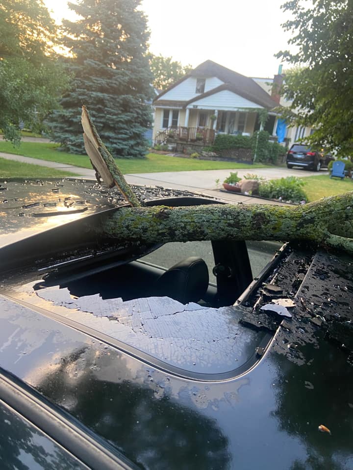
1230 AM TSTM WND DMG DES PLAINES 42.04N 87.89W
07/05/2022 COOK IL PUBLIC
[DELAYED REPORT] PICTURE OF A FIVE INCH
DIAMETER TREE LIMB WEDGED IN A CAR SUNROOF.
1237 AM TSTM WND DMG ELMHURST 41.90N 87.94W
07/05/2022 DUPAGE IL PUBLIC
HALF OF A TREE DOWNED ONTO A ROAD. TIME
ESTIMATED FROM RADAR.
1237 AM TSTM WND DMG WARRENVILLE 41.82N 88.17W
07/05/2022 DUPAGE IL PUBLIC
LARGE TREE LIMB SNAPPED. TIME ESTIMATED FROM
RADAR.
1241 AM TSTM WND DMG LISLE 41.80N 88.07W
07/05/2022 DUPAGE IL PUBLIC
LARGE TREE LIMB DOWNED. TIME ESTIMATED FROM
RADAR.
1242 AM TSTM WND GST OHARE AIRPORT 41.98N 87.90W
07/05/2022 M55 MPH COOK IL ASOS
ASOS STATION KORD CHICAGO OHARE AIRPORT
RECORDED 55MPH GUST.
1242 AM TSTM WND DMG 1 S DOWNERS GROVE 41.77N 88.01W
07/05/2022 DUPAGE IL NWS EMPLOYEE
NUMEROUS SMALL BRANCHES DOWNED ACROSS
SOUTHERN DOWNERS GROVE.
1244 AM TSTM WND DMG WESTCHESTER 41.85N 87.88W
07/05/2022 COOK IL PUBLIC
[DELAYED REPORT] LARGE ONE FOOT DIAMETER
TREE SNAPPED IN A FRONT YARD. TIME ESTIMATED
BASED ON RADAR.
1252 AM TSTM WND GST DUPAGE AIRPORT 41.92N 88.25W
07/05/2022 M52 MPH DUPAGE IL ASOS
ASOS STATION KDPA DUPAGE COUNTY AIRPORT
RECORDED 52MPH GUST.
1253 AM TSTM WND GST MIDWAY AIRPORT 41.78N 87.76W
07/05/2022 M51 MPH COOK IL ASOS
ASOS STATION KMDW CHICAGO MIDWAY AIRPORT
RECORDED 51MPH GUST.
0104 AM HEAVY RAIN 2 SSE UNION 42.20N 88.53W
07/05/2022 M4.34 INCH MCHENRY IL PUBLIC
PRIVATE WEATHER STATION RECORDED 4.34 INCHES
STORM TOTAL RAINFALL SINCE 11:30PM.
0104 AM HEAVY RAIN 1 NNE ELGIN 42.05N 88.27W
07/05/2022 M3.38 INCH KANE IL PUBLIC
PRIVATE WEATHER STATION RECORDED 3.38 INCHES
OF RAIN IN ABOUT 1 HOUR.
0114 AM HEAVY RAIN 1 W ELGIN 42.04N 88.31W
07/05/2022 M3.25 INCH KANE IL PUBLIC
PRIVATE WEATHER STATION RECORDED 3.25 INCHES
OF RAIN IN ABOUT 1 HOUR.
0115 AM TSTM WND DMG 1 WNW HAMMOND 41.59N 87.51W
07/05/2022 LAKE IN TRAINED SPOTTER
TREE DOWNED NEAR THE INTERSECTION OF 169TH
ST. AND JACKSON AVE. IN HAMMOND. TIME
ESTIMATED FROM RADAR.
0119 AM MARINE TSTM WIND 3 NE EAST CHICAGO 41.68N 87.42W
07/05/2022 M43 MPH LMZ743 IN MESONET
0140 AM MARINE TSTM WIND 4 NE TOWN OF PINES 41.73N 86.91W
07/05/2022 M48 MPH LMZ745 IN MESONET
MESONET STATION MCYI3 2 WNW MICHIGAN CITY.
July 5th Storm Reports
 |
PRELIMINARY LOCAL STORM REPORT...SUMMARY
NATIONAL WEATHER SERVICE CHICAGO IL
719 PM CDT THU JUL 7 2022

..TIME...   ...EVENT...      ...CITY LOCATION...     ...LAT.LON...
..DATE...   ....MAG....      ..COUNTY LOCATION..ST.. ...SOURCE....
            ..REMARKS..

0600 PM     TSTM WND DMG     1 E SHIRLAND            42.45N 89.17W
07/05/2022                   WINNEBAGO          IL   BROADCAST MEDIA

            TREE SNAPPED NEAR SHIRLAND ROAD AND MOODY
            ROAD EAST OF SHIRLAND. TREE BLOCKING
            ROADWAY. TREE APPEARED TO BE DEAD. TIME
            ESTIMATED BY RADAR.

0610 PM     TSTM WND DMG     1 W WOODSTOCK           42.31N 88.47W
07/05/2022                   MCHENRY            IL   PUBLIC

            [DELAYED REPORT] PHOTO OF TREE DAMAGE AT
            EMRICSON PARK, SOUTH STREET. TIME ESTIMATED
            BASED ON RADAR.

0614 PM     TSTM WND DMG     HARVARD                 42.42N 88.61W
07/05/2022                   MCHENRY            IL   PUBLIC

            TREE DOWNED ONTO A GARAGE.

0700 PM     TSTM WND GST     5 NW MARENGO            42.31N 88.66W
07/05/2022  M54 MPH          MCHENRY            IL   MESONET

            ILLINOIS DOT STATION RECORDED 54 MPH GUST
            NORTHWEST OF MARENGO.

0708 PM     TSTM WND DMG     1 W BELVIDERE           42.26N 88.86W
07/05/2022                   BOONE              IL   TRAINED SPOTTER

            TREE BRANCHES DOWNED IN BELVIDERE. 40-FT
            TREE DOWNED ONTO POWER LINES NEAR LINCOLN
            AVENUE AND APPLETON ROAD. TIME ESTIMATED BY
            RADAR.

0730 PM     FLOOD            3 S GREENWOOD           42.35N 88.39W
07/05/2022                   MCHENRY            IL   EMERGENCY MNGR

            MINOR PONDING OF WATER ON IL-120 EAST OF
            WOODSTOCK. LOCATION APPROXIMATE.

0735 PM     TSTM WND DMG     4 NW HAMPSHIRE          42.14N 88.58W
07/05/2022                   KANE               IL   TRAINED SPOTTER

            SMALL TREE SNAPPED AT BASE, BLOCKING MELMS
            ROAD NORTHWEST OF HAMPSHIRE. RELAYED VIA
            SPOTTER NETWORK. TIME ESTIMATED BY RADAR.

0744 PM     HEAVY RAIN       2 SSE UNION             42.20N 88.53W
07/05/2022  M2.25 INCH       MCHENRY            IL   PUBLIC

            PRIVATE WEATHER STATION RECORDED 2.25 INCHES
            OF RAINFALL IN 30 MINUTES.

0745 PM     FLOOD            2 W LAKEWOOD            42.23N 88.42W
07/05/2022                   MCHENRY            IL   EMERGENCY MNGR

            SIGNIFICANT PONDING ON IL-47 SOUTH OF
            IL-176. LOCATION APPROXIMATE.

0745 PM     HAIL             2 SSE GENOA             42.07N 88.68W
07/05/2022  M1.00 INCH       DE KALB            IL   TRAINED SPOTTER

            1 INCH HAIL REPORTED JUST SOUTH OF GENOA.
            TIME ESTIMATED BY RADAR.

0807 PM     TSTM WND DMG     BURLINGTON              42.05N 88.55W
07/05/2022                   KANE               IL   PUBLIC

            TREES AND POWER LINES DOWNED ONTO CENTER
            STREET IN BURLINGTON. TIME ESTIMATED FROM
            RADAR.

0812 PM     TSTM WND DMG     1 ESE ELGIN             42.03N 88.27W
07/05/2022                   KANE               IL   PUBLIC

            [DELAYED REPORT] SEVERAL 5 INCH DIAMETER
            TREE LIMBS DOWN AROUND TOWN. TIME ESTIMATED
            BASED ON RADAR.

0812 PM     TSTM WND DMG     SOUTH ELGIN             41.99N 88.29W
07/05/2022                   KANE               IL   PUBLIC

            [DELAYED REPORT] LARGE TREE UPROOTED. TIME
            ESTIMATED BASED ON RADAR.

0840 PM     FLOOD            3 S MARENGO             42.21N 88.62W
07/05/2022                   MCHENRY            IL   TRAINED SPOTTER

            SEVERAL INCHES OF STANDING WATER ON IL-23
            SOUTH OF MARENGO.

0840 PM     FLOOD            1 SSW HAMPSHIRE         42.09N 88.53W
07/05/2022                   KANE               IL   PUBLIC

            MULTIPLE PUBLIC REPORTS RECEIVED OF STREET
            FLOODING IN AND NEAR HAMPSHIRE. RELAYED VIA
            MPING.

0900 PM     TSTM WND GST     5 ENE HERBERT           42.18N 88.70W
07/05/2022  M51 MPH          MCHENRY            IL   MESONET

            ILLINOIS DOT STATION RECORDED 51MPH GUST
            SOUTHWEST OF MARENGO.

0920 PM     TSTM WND DMG     1 WNW PALOS HILLS       41.71N 87.84W
07/05/2022                   COOK               IL   TRAINED SPOTTER

            SMALL TREE SNAPPED AND MULTIPLE LARGE TREE
            LIMBS AND BRANCHES DOWNED. TIME ESTIMATED
            FROM RADAR.

0920 PM     TSTM WND DMG     1 SSE WILLOW SPRINGS    41.73N 87.85W
07/05/2022                   COOK               IL   PUBLIC

            REPORT OF SEVERAL TREE LIMBS DOWN. DAMAGE
            WAS ESTIMATED TO HAVE OCCURRED BETWEEN 9:15
            PM AND 9:30 PM.

0954 PM     HEAVY RAIN       2 SSE UNION             42.20N 88.53W
07/05/2022  M4.84 INCH       MCHENRY            IL   PUBLIC

            PRIVATE WEATHER STATION RECORDED 4.84 INCHES
            OF RAINFALL. STORM TOTAL SO FAR SINCE 715PM.

0959 PM     HEAVY RAIN       5 SSW MARENGO           42.19N 88.64W
07/05/2022  M3.39 INCH       MCHENRY            IL   PUBLIC

            PRIVATE WEATHER STATION RECORDED 3.39 INCHES
            OF RAINFALL. STORM TOTAL SO FAR SINCE 715PM.

0959 PM     HEAVY RAIN       1 WNW HAMPSHIRE         42.10N 88.54W
07/05/2022  M3.19 INCH       KANE               IL   PUBLIC

            PRIVATE WEATHER STATION RECORDED 3.19 INCHES
            OF RAINFALL. STORM TOTAL SO FAR SINCE 730PM.

1024 PM     HEAVY RAIN       2 SSE TIMBERLANE        42.31N 88.84W
07/05/2022  M3.01 INCH       BOONE              IL   PUBLIC

            PRIVATE WEATHER STATION RECORDED 3.01 INCHES
            OF RAINFALL. STORM TOTAL SO FAR SINCE
            6:45PM.

0100 AM     FLASH FLOOD      1 ESE UNION             42.23N 88.53W
07/06/2022                   MCHENRY            IL   PUBLIC

            [DELAYED REPORT] IL RAILWAY MUSEUM CLOSED
            7/6 DUE TO FLOODING. PHOTO SHOWS MULTIPLE
            FEET OF INUNDATION SEVERAL HOURS AFTER
            RAINFALL ENDED. TIME APPROXIMATE.

0800 AM     HEAVY RAIN       3 NNW CHERRY VALLEY     42.28N 88.97W
07/06/2022  M3.00 INCH       WINNEBAGO          IL   TRAINED SPOTTER

            RAINFALL TOTAL FROM JULY 5TH AFTERNOON
            STORMS.

0100 PM     FLOOD            GARDEN PRAIRIE          42.26N 88.72W
07/06/2022                   BOONE              IL   PUBLIC

            PHOTO SHARED ON SOCIAL MEDIA SHOWS LOW-LYING
            AREAS ALONG THE KISHWAUKEE RIVER NEAR GARDEN
            PRAIRIE FLOODED.

0230 PM     FLOOD            1 NE GENOA              42.11N 88.68W
07/06/2022                   DE KALB            IL   PUBLIC

            PHOTO SHARED ON SOCIAL MEDIA SHOWS A LARGE
            PORTION OF KIERNAN PARK IN GENOA INUNDATED
            WITH WATER.

0630 PM     FLOOD            2 N HAMPSHIRE           42.12N 88.54W
07/06/2022                   KANE               IL   PUBLIC

            1 TO 2 FEET OF STANDING WATER REPORTED IN
            LOW-LYING AREAS. WATER WAS STILL RISING AT
            TIME OF REPORT. PERSONAL WEATHER STATION HAD
            RECORDED 6.5 INCHES OF RAIN OVER 2 DAYS
            ENDING THE MORNING OF JULY 6TH.
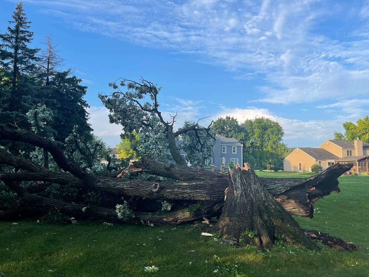
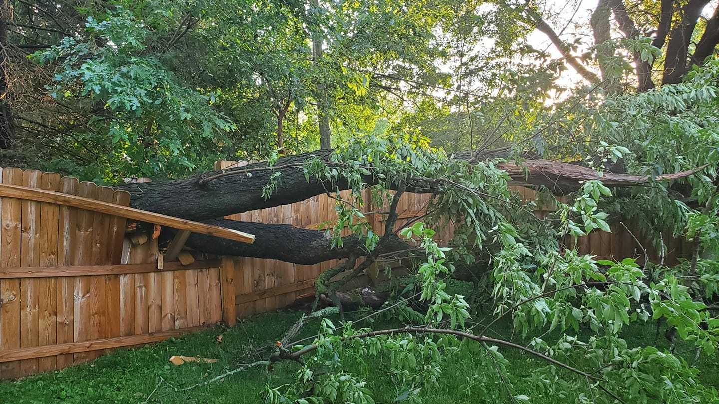
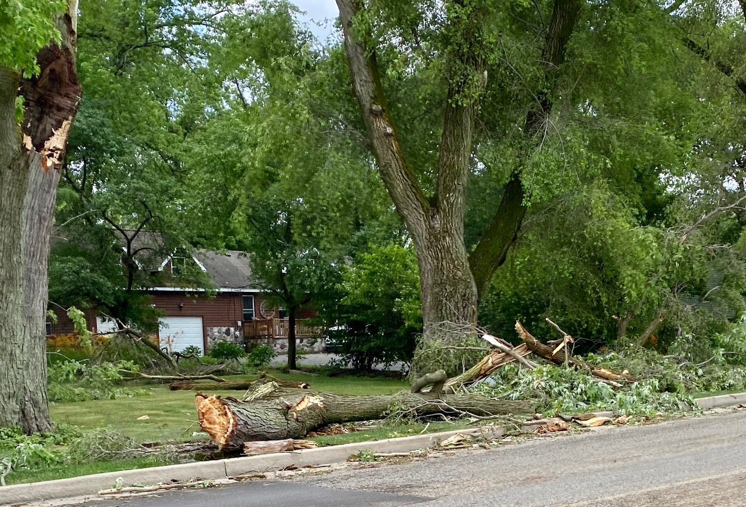
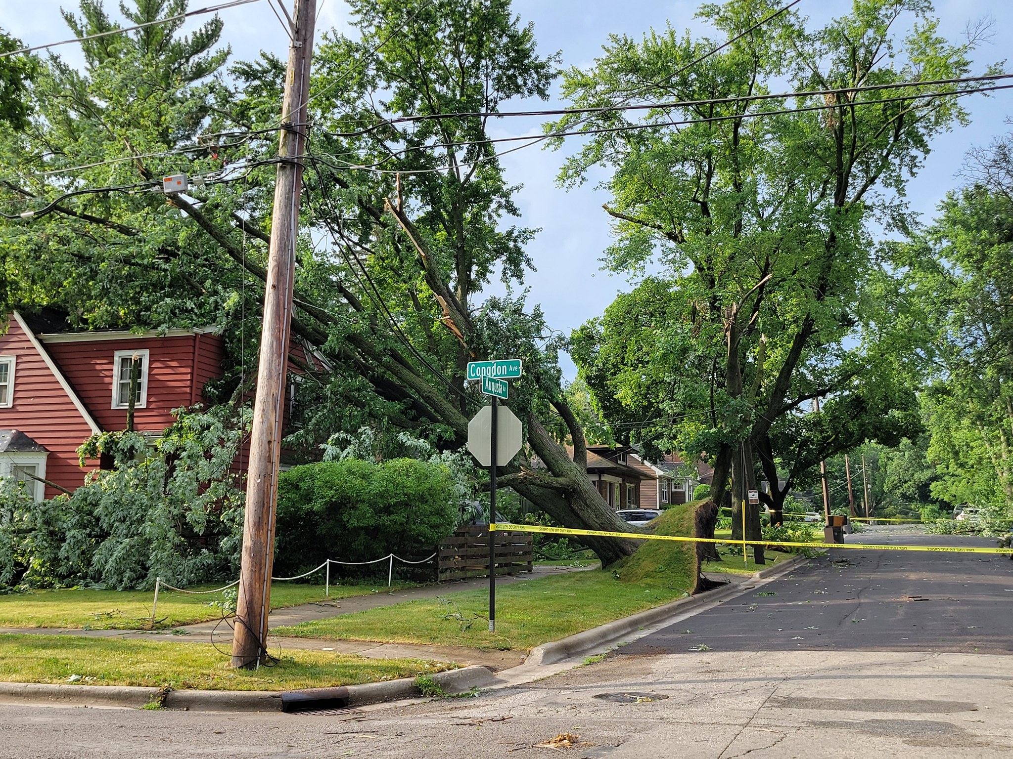
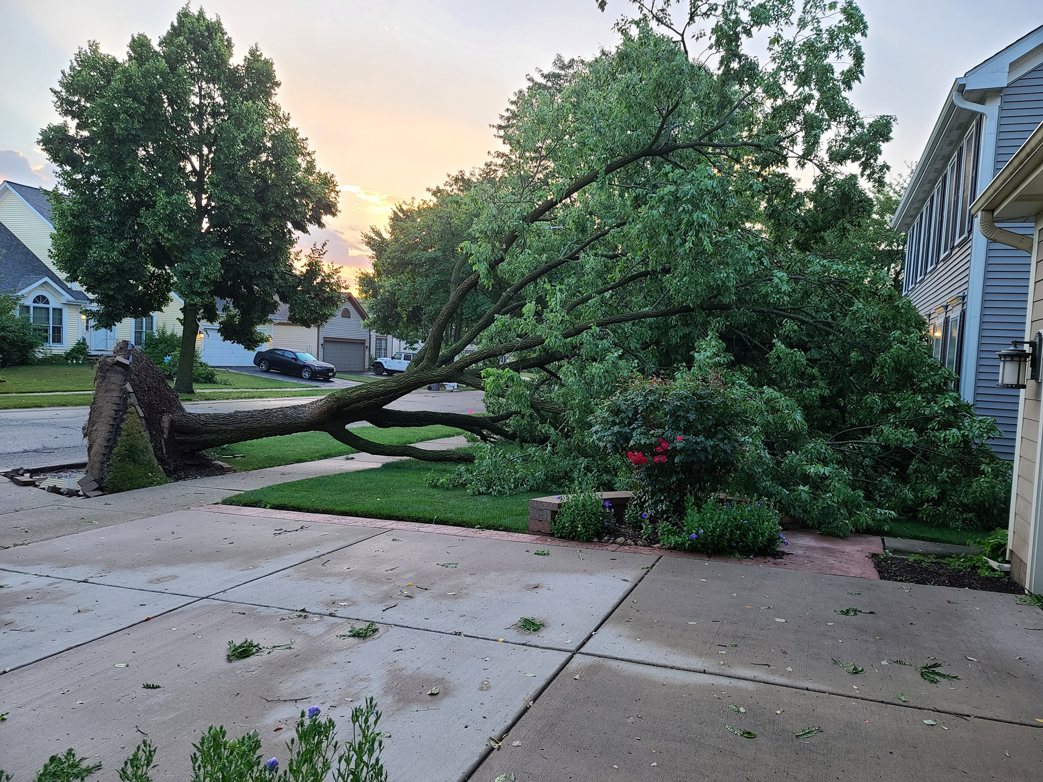
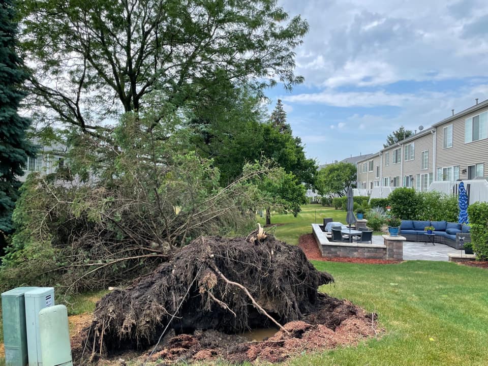
Photos
 |
 |
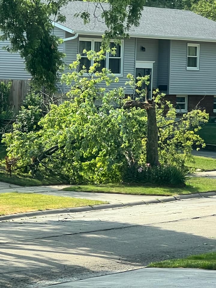 |
| Damage to a radio tower in Flanagan (courtesy of Adam Baron) | Storm damage in Des Plaines (courtesy of Jodi Bechtold) | Tree damage in Hanover Park (courtesy of Brian George) |
|
|
|
|
| Tree damage in Sleepy Hollow (courtesy of Dana Pautsch) | Tree damage in Hampshire (courtesy of Max Beecher) | Tree damage in Crystal Lake (courtesy of Elizabeth Novak) |
|
|
|
|
| Tree damage in Elgin (courtesy of Antonio Rios) | Tree damage in Elgin (courtesy of Donna Peterson) | Tree damage in Bartlett (courtesy of Tim Miller) |
Radar
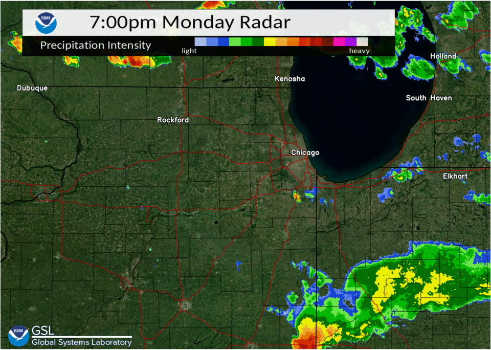 |
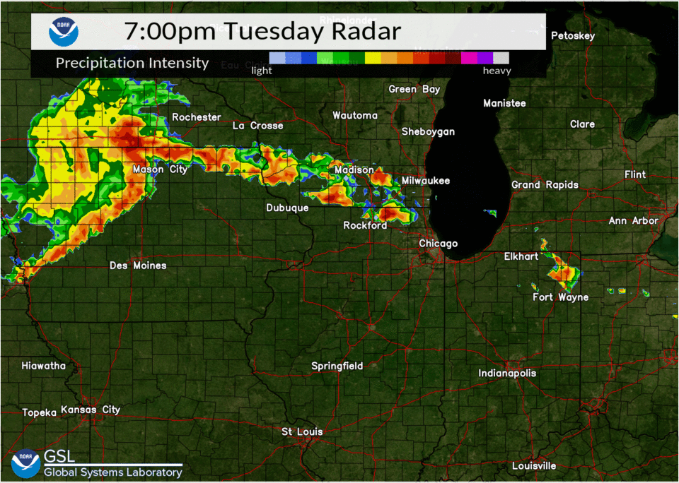 |
| July 4th (evening) radar loop | July 5th radar loop |
2-Day Rainfall
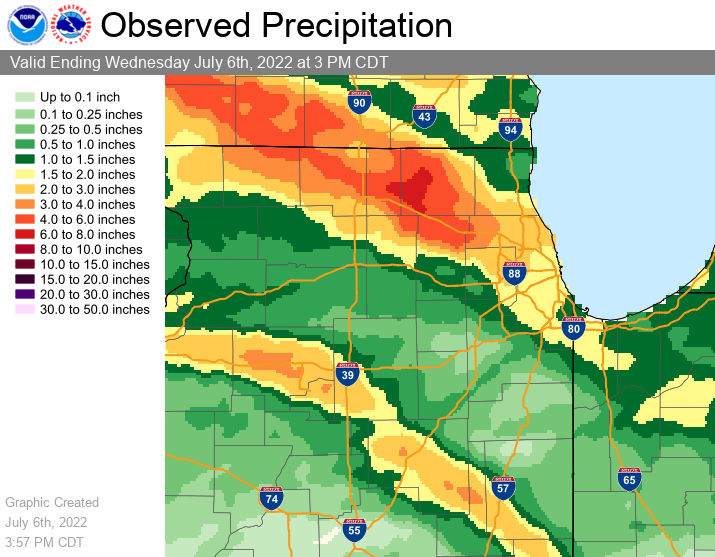 |
| 2-day rainfall map |
PUBLIC INFORMATION STATEMENT
NATIONAL WEATHER SERVICE CHICAGO/ROMEOVILLE IL
0359 PM CDT WED JUL 06 2022

...2-DAY RAINFALL ROUND-UP...

THE FOLLOWING ARE RAINFALL AMOUNTS FOR THE PREVIOUS 2 DAYS
AS MEASURED IN THE MORNING BY NWS COOPERATIVE OBSERVERS
AND COCORAHS OBSERVERS. OBSERVATIONS ARE USUALLY
TAKEN AT 7 AM.

AMOUNTS UNDER ONE INCH HAVE BEEN FILTERED OUT OF THIS REPORT.

ILLINOIS                                 2-DAY RAINFALL
  LOCATION (COUNTY):                         AMT(INCHES) REPORTS

  ELGIN (KANE).................................5.65     (2)
  GILBERTS (KANE)..............................5.39     (2)
  HARVARD (MCHENRY)............................5.35     (2)
  WOODSTOCK 4SW (MCHENRY).......................5.1     (2)
  HARVARD 3SSE (MCHENRY)........................4.6     (2)
  CHATSWORTH (LIVINGSTON).......................4.5     (1)
  ELGIN 2W (KANE)...............................4.5     (2)
  CHATSWORTH (LIVINGSTON).......................4.5     (1)
  HUNTLEY (MCHENRY)............................4.47     (2)
  BULL VALLEY 2WNW (MCHENRY)...................3.95     (2)
  GENOA (DE KALB)...............................3.8     (2)
  ALGONQUIN 2W (MCHENRY)........................3.5     (2)
  PERU 1SW (LA SALLE)..........................3.45     (2)
  LA SALLE (LA SALLE)..........................3.41     (2)
  PERU 1ENE (LA SALLE).........................3.33     (2)
  BARRINGTON (LAKE)............................3.33     (2)
  ALGONQUIN 1N (MCHENRY).......................3.29     (2)
  CRYSTAL LAKE 1WSW (MCHENRY)..................3.27     (2)
  HOFFMAN ESTATES 5W (COOK)....................3.22     (2)
  ELGIN 8WSW (KANE).............................3.2     (2)
  CARY (MCHENRY)...............................3.15     (2)
  CAPRON (BOONE)...............................3.14     (2)
  BARTLETT 1SE (DU PAGE).......................3.08     (2)
  HOFFMAN ESTATES 2SE (COOK)...................3.02     (2)
  SCHAUMBURG 2E (COOK)..........................2.9     (2)
  VILLA PARK 1NW (DU PAGE).....................2.88     (2)
  ELMHURST 1ESE (DU PAGE)......................2.82     (2)
  ELMHURST 2SE (DU PAGE).......................2.75     (2)
  PALATINE 1NNE (COOK).........................2.75     (2)
  WHEELING (COOK)..............................2.63     (2)
  ARLINGTON HEIGHTS 1SW (COOK).................2.62     (2)
  SCHAUMBURG (DU PAGE)..........................2.6     (2)
  LOMBARD 1NNW (DU PAGE).......................2.52     (2)
  CHICAGO 6ESE (COOK)..........................2.47     (2)
  GLEN ELLYN 1WSW (DU PAGE)....................2.45     (2)
  CAROL STREAM (DU PAGE).......................2.41     (2)
  ROCKFORD (WINNEBAGO).........................2.39     (2)
  GLENCOE (COOK)...............................2.39     (2)
  ST. CHARLES 6NW (KANE).......................2.38     (2)
  BUCKLEY (IROQUOIS)...........................2.33     (2)
  ELK GROVE VILLAGE 2WSW (COOK)................2.32     (2)
  ROCKFORD 6S (WINNEBAGO)......................2.31     (2)
  PALATINE 1E (COOK)...........................2.24     (2)
  WHEATON 2NNE (DU PAGE).......................2.23     (2)
  LINCOLNWOOD 3E (COOK)........................2.21     (2)
  ELMHURST (DU PAGE)............................2.2     (2)
  MIDWAY COOP (COOK)...........................2.13     (2)
  LINCOLNWOOD 2E (COOK)........................2.09     (2)
  FLOSSMOOR 1ESE (COOK)........................2.08     (2)
  CRYSTAL LAKE (MCHENRY).......................2.08     (1)
  MIDWAY (COOK)................................2.06     (3)
  WONDER LAKE 1NE (MCHENRY)....................2.05     (1)
  LA GRANGE PARK 1SSW (COOK)...................2.05     (2)
  ELK GROVE VILLAGE 1ESE (COOK)................2.02     (2)
  OAK LAWN (COOK)...............................2.0     (2)
  BUFFALO GROVE 2N (LAKE)......................1.99     (2)
  BRIDGEVIEW 1NNW (COOK).......................1.99     (2)
  FAIRBURY (LIVINGSTON)........................1.96     (1)
  ROGERS PARK 2SW (COOK).......................1.94     (2)
  HOMEWOOD (COOK)..............................1.93     (2)
  PONTIAC 1SE (LIVINGSTON).....................1.87     (2)
  RIVERWOODS (LAKE)............................1.83     (2)
  OAK PARK 1SW (COOK)..........................1.83     (2)
  OAK LAWN 1N (COOK)...........................1.82     (2)
  LAKEMOOR 2NW (MCHENRY).......................1.81     (2)
  STREATOR 1WSW (LA SALLE).....................1.78     (2)
  LANSING (COOK)...............................1.71     (2)
  WOODSTOCK 5NW (MCHENRY)......................1.69     (1)
  HARWOOD HEIGHTS (COOK).......................1.69     (2)
  ELMWOOD PARK 1ESE (COOK).....................1.69     (2)
  OAK LAWN 2WNW (COOK).........................1.67     (2)
  CHICAGO RIDGE (COOK).........................1.65     (2)
  STREATOR (LIVINGSTON)........................1.57     (2)
  MIDLOTHIAN 1SE (COOK)........................1.57     (2)
  CHICAGO 6NNE (COOK)..........................1.57     (2)
  OAK LAWN 2SE (COOK)..........................1.56     (2)
  O'HARE AIRPORT (COOK)........................1.56     (2)
  AURORA 4SE (DU PAGE).........................1.52     (2)
  NAPERVILLE 4SSW (WILL).......................1.51     (2)
  GLEN ELLYN 2SSE (DU PAGE)....................1.51     (1)
  PALOS PARK 1SW (COOK).........................1.5     (2)
  MUNDELEIN (LAKE).............................1.47     (2)
  NORTH AURORA 2NE (KANE)......................1.46     (2)
  LAKE ZURICH 1N (LAKE)........................1.45     (2)
  HIGHWOOD 1S (LAKE)...........................1.45     (2)
  OAK PARK 1NNE (COOK).........................1.44     (2)
  RAVENSWOOD MANOR (COOK)......................1.42     (2)
  MUNDELEIN 2WNW (LAKE)........................1.39     (2)
  BANNOCKBURN (LAKE)...........................1.37     (2)
  LIBERTYVILLE 2ESE (LAKE).....................1.36     (2)
  HEBRON (MCHENRY).............................1.34     (1)
  WESTMONT (DU PAGE)............................1.3     (2)
  LAKE BLUFF 1W (LAKE)..........................1.3     (2)
  AURORA (KANE)................................1.29     (2)
  EMINGTON 2SSE (LIVINGSTON)...................1.26     (2)
  MUNDELEIN (LAKE).............................1.24     (2)
  BURR RIDGE 2SW (DU PAGE).....................1.19     (2)
  OTTAWA (LA SALLE)............................1.16     (2)
  HOMER GLEN 1ENE (WILL).......................1.16     (2)
  GLEN ELLYN (DU PAGE).........................1.16     (1)
  WILLOW SPRINGS (COOK)........................1.14     (1)
  NAPERVILLE 2SE (DU PAGE).....................1.11     (2)
  BOLINGBROOK 3NE (DU PAGE)....................1.11     (2)
  CRETE 3E (WILL)..............................1.09     (2)
  PARK FOREST (COOK)...........................1.08     (2)
  AURORA 4NE (DU PAGE).........................1.06     (2)
  BATAVIA (KANE)...............................1.06     (2)
  LISLE MORTON ARB (DU PAGE)...................1.05     (2)
  LAKE VILLA 1SSW (LAKE).......................1.03     (2)

INDIANA                                    2-DAY RAINFALL
  LOCATION (COUNTY):                         AMT(INCHES) REPORTS

  HAMMOND 1SSW (LAKE)..........................1.68     (2)
  LAKES OF THE FOUR SEASONS (PORTER)...........1.64     (2)
  VALPARAISO 4SW (PORTER)......................1.54     (2)
  ST. JOHN (LAKE)..............................1.45     (2)
  WHEATFIELD 5W (JASPER).......................1.43     (2)
  HEBRON 4NE (PORTER)...........................1.4     (2)
  SCHERERVILLE 1E (LAKE)........................1.4     (2)
  CROWN POINT 1N (LAKE).........................1.4     (2)
  DYER 1WNW (LAKE).............................1.29     (1)
  VALPARAISO 2NW (PORTER)......................1.26     (2)
  DE MOTTE 6S (JASPER).........................1.25     (2)
  CROWN POINT (LAKE)...........................1.23     (1)
  VALPARAISO 1NNW (PORTER).....................1.22     (2)
  GRIFFITH 1N (LAKE)...........................1.22     (2)
  PORTAGE 3E (PORTER)..........................1.21     (2)
  WHEATFIELD 3S (JASPER).......................1.18     (2)
  HEBRON 1NW (PORTER)..........................1.17     (2)
  VALPARAISO 2WNW (PORTER).....................1.17     (2)
  VALPARAISO (PORTER)..........................1.14     (2)
  VALPARAISO 2N (PORTER).......................1.06     (2)
  VALPARAISO 2WSW (PORTER).....................1.04     (2)
  VALPARAISO 1NE (PORTER)......................1.03     (2)
  VALPARAISO 1SE (PORTER)......................1.02     (2)
  GARY 5ENE (LAKE).............................1.01     (2)
  WHEATFIELD 4WSW (JASPER).....................1.01     (2)

$$
Additional Info
 |
Media use of NWS Web News Stories is encouraged! Please acknowledge the NWS as the source of any news information accessed from this site. Additional recaps can be found on the NWS Chicago Past Events Page |
|