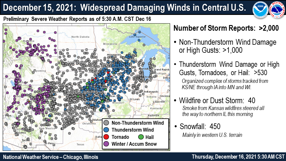
Overview
|
Fast Facts:
|
|
High Winds
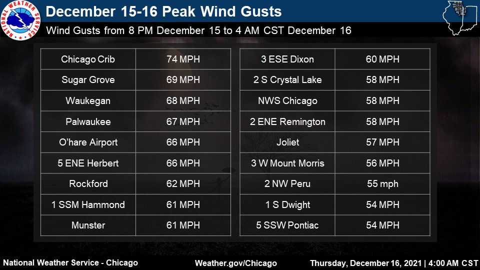 |
| Highest Wind Gusts |
Public Information Statement
National Weather Service Chicago IL
254 AM CST Thu Dec 16 2021

...HIGHEST 12-HOUR WIND REPORTS AS OF 3 AM CST 12/16/2021...

Location                     Speed     Time/Date
----------------------------------------------------
Harrison-Dever Crib          74 MPH    0918 PM 12/15
Sugar Grove                  69 MPH    1134 PM 12/15
Waukegan                     68 MPH    0231 AM 12/16
Herbert 5 ENE (McHenry DOT)  66 MPH    0920 PM 12/15
Ohare Airport                66 MPH    1137 PM 12/15
Rockford Airport             62 MPH    1154 PM 12/15
Munster                      61 MPH    1135 PM 12/15
Dixon 3 ESE (UP Rail)        60 MPH    0935 PM 12/15
NWS Chicago-Romeoville       58 MPH    1100 PM 12/15
1.7 E Remington (INDOT)      58 MPH    1116 PM 12/15
Crystal Lake (McHenry DOT)   58 MPH    1120 PM 12/15
Joliet                       57 MPH    1145 PM 12/15
Mount Morris                 56 MPH    1046 PM 12/15
Peru Airport                 55 MPH    1055 PM 12/15
Pontiac 5 SSW (UP Rail)      54 MPH    0903 PM 12/15
Dwight                       54 MPH    0930 PM 12/15
DeKalb Airport               53 MPH    1055 PM 12/15
Pontiac Airport              52 MPH    1015 PM 12/15
Rochelle                     52 MPH    1109 PM 12/15
Saint Charles                52 MPH    1125 PM 12/15
Highland Park (UP Rail)      52 MPH    1157 PM 12/15
Waukegan Harbor              52 MPH    1000 PM 12/15
1 SSW Lombard                51 MPH    0925 PM 12/15
Plainfield                   51 MPH    1130 PM 12/15
Rochelle 4 WSW (UP Rail)     50 MPH    1044 PM 12/15

Observations are collected from a variety of sources with varying
equipment and exposures. We thank all volunteer weather observers
for their dedication. Not all data listed are considered official.
Storm Reports
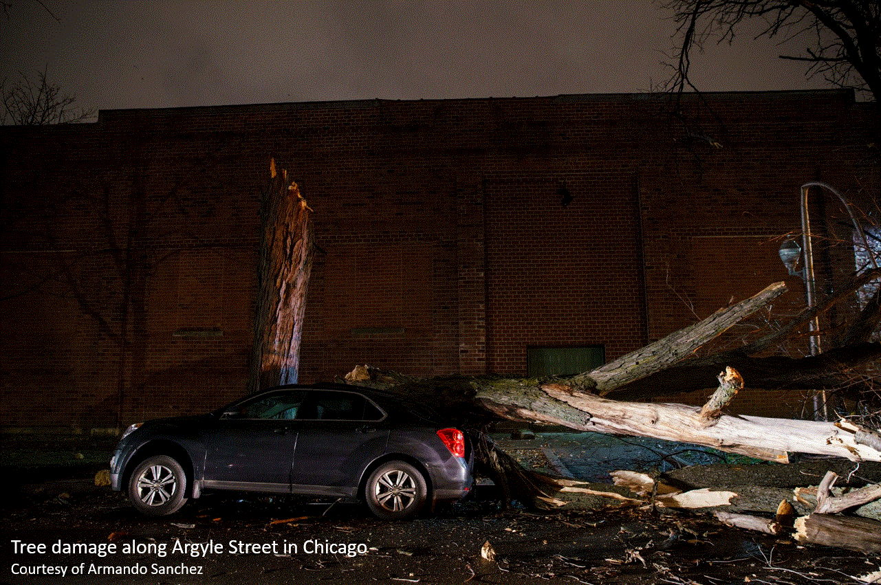 |
| Wind damage in Chicago. |
PRELIMINARY LOCAL STORM REPORT...SUMMARY
NATIONAL WEATHER SERVICE CHICAGO IL
422 AM CST THU DEC 16 2021

..TIME...   ...EVENT...      ...CITY LOCATION...     ...LAT.LON...
..DATE...   ....MAG....      ..COUNTY LOCATION..ST.. ...SOURCE....
            ..REMARKS..

0800 PM     NON-TSTM WND DMG 1 E TRIUMPH             41.50N 89.01W
12/15/2021                   LA SALLE           IL   PUBLIC

            TREE DOWNED ON NORTH 39TH ROAD EAST OF
            TRIUMPH. TIME ESTIMATED.

0815 PM     NON-TSTM WND DMG DOWNERS GROVE           41.77N 88.03W
12/15/2021                   DUPAGE             IL   COUNTY OFFICIAL

            DOWNED POWER LINES THAT CLOSED 63RD STREET
            IN DOWNERS GROVE.

0845 PM     NON-TSTM WND DMG 2 E WAYNE               41.95N 88.22W
12/15/2021                   DUPAGE             IL   EMERGENCY MNGR

            MULTIPLE POLE POWERS AND POWER LINES DOWNED.

0900 PM     NON-TSTM WND DMG JOHNSBURG               42.38N 88.24W
12/15/2021                   MCHENRY            IL   PUBLIC

            MEDIUM SIZED PINE TREE DOWNED. TIME
            ESTIMATED.

0903 PM     NON-TSTM WND GST 5 SSW PONTIAC           40.82N 88.67W
12/15/2021  M54 MPH          LIVINGSTON         IL   MESONET

            MESONET STATION UP797 PONTIAC 5 SSW (UP
            RAIL).

0918 PM     NON-TSTM WND GST HARRISON-DEVER CRIB     41.92N 87.57W
12/15/2021  M74 MPH          LMZ741             IL   MESONET

            64KT OR 73.6 MPH GUST. MESONET STATION CHII2
            HARRISON-DEVER CRIB.

0920 PM     NON-TSTM WND GST 5 ENE HERBERT           42.18N 88.70W
12/15/2021  M66 MPH          MCHENRY            IL   MESONET

            MESONET STATION IMC01 HERBERT 5 ENE (MCHENRY
            DOT).

0925 PM     NON-TSTM WND GST 2 SSW LOMBARD           41.86N 88.02W
12/15/2021  M51 MPH          DUPAGE             IL   MESONET

            MESONET STATION GMBRD 1 SSW LOMBARD.

0930 PM     NON-TSTM WND GST 1 S DWIGHT              41.09N 88.43W
12/15/2021  M54 MPH          LIVINGSTON         IL   MESONET

            MESONET STATION EW5866 DWIGHT.

0935 PM     NON-TSTM WND GST 3 ESE DIXON             41.83N 89.43W
12/15/2021  M60 MPH          LEE                IL   MESONET

            MESONET STATION UP060 DIXON 3 ESE (UP RAIL).

1000 PM     NON-TSTM WND GST 2 E WAUKEGAN            42.36N 87.81W
12/15/2021  M52 MPH          LMZ740             IL   MESONET

            MESONET STATION WHRI2 WAUKEGAN HARBOR.

1010 PM     NON-TSTM WND DMG 1 NW UPTOWN - CHICAGO   41.97N 87.66W
12/15/2021                   COOK               IL   PUBLIC

            LARGE TREE DOWNED ON MULTIPLE CARS.

1015 PM     NON-TSTM WND GST 3 NNE PONTIAC           40.92N 88.62W
12/15/2021  M52 MPH          LIVINGSTON         IL   AWOS

            AWOS STATION KPNT PONTIAC AIRPORT.

1044 PM     NON-TSTM WND GST 4 WSW ROCHELLE          41.90N 89.13W
12/15/2021  M50 MPH          OGLE               IL   MESONET

            MESONET STATION UP086 ROCHELLE 4 WSW (UP
            RAIL).

1046 PM     NON-TSTM WND GST 3 W MOUNT MORRIS        42.05N 89.49W
12/15/2021  M56 MPH          OGLE               IL   MESONET

            MESONET STATION FW3055 MOUNT MORRIS.

1055 PM     NON-TSTM WND GST 1 NNW CORTLAND          41.93N 88.70W
12/15/2021  M53 MPH          DE KALB            IL   AWOS

            AWOS STATION KDKB DEKALB AIRPORT.

1055 PM     NON-TSTM WND GST 2 NW PERU               41.35N 89.15W
12/15/2021  M55 MPH          LA SALLE           IL   AWOS

            AWOS STATION KVYS PERU AIRPORT.

1100 PM     NON-TSTM WND GST NWS CHICAGO-ROMEOVILLE  41.60N 88.09W
12/15/2021  M58 MPH          WILL               IL   OFFICIAL NWS OBS

            MEASURED 58 MPH WIND GUST AT KLOT.

1109 PM     NON-TSTM WND GST 1 NW ROCHELLE           41.94N 89.08W
12/15/2021  M52 MPH          OGLE               IL   MESONET

            MESONET STATION CW8255 ROCHELLE.

1116 PM     NON-TSTM WND GST 2 ENE REMINGTON         40.77N 87.12W
12/15/2021  M58 MPH          JASPER             IN   MESONET

            MESONET STATION IN048 1.7 E REMINGTON
            (INDOT).

1120 PM     NON-TSTM WND GST 2 S CRYSTAL LAKE        42.21N 88.32W
12/15/2021  M58 MPH          MCHENRY            IL   MESONET

            MESONET STATION IMC03 CRYSTAL LAKE (MCHENRY
            DOT).

1125 PM     NON-TSTM WND GST 1 SW ST. CHARLES        41.91N 88.32W
12/15/2021  M52 MPH          KANE               IL   MESONET

            MESONET STATION FW3994 SAINT CHARLES.

1130 PM     NON-TSTM WND DMG STREAMWOOD              42.02N 88.17W
12/15/2021                   COOK               IL   BROADCAST MEDIA

            LARGE TREE DOWNED ON CAR AT RESIDENCE.

1130 PM     NON-TSTM WND GST 2 NW PLAINFIELD         41.63N 88.23W
12/15/2021  M51 MPH          WILL               IL   MESONET

            MESONET STATION FW8710 PLAINFIELD.

1134 PM     NON-TSTM WND GST SUGAR GROVE             41.76N 88.44W
12/15/2021  M69 MPH          KANE               IL   ASOS


1135 PM     NON-TSTM WND GST 1 SSW HAMMOND           41.57N 87.51W
12/15/2021  M61 MPH          LAKE               IN   MESONET

            MESONET STATION EW9197 MUNSTER.

1137 PM     NON-TSTM WND GST OHARE AIRPORT           41.98N 87.90W
12/15/2021  M66 MPH          COOK               IL   ASOS


1145 PM     NON-TSTM WND GST JOLIET                  41.53N 88.08W
12/15/2021  M57 MPH          WILL               IL   TRAINED SPOTTER

            RELAYED VIA SOCIAL MEDIA.

1148 PM     NON-TSTM WND DMG 1 W BATAVIA             41.85N 88.33W
12/15/2021                   KANE               IL   TRAINED SPOTTER

            ROUGHLY 14 TO 15 FOOT EVERGREEN TREE
            UPROOTED AND NOW LEANING ON POWER LINES
            ACROSS FROM BATAVIA HIGH SCHOOL.

1154 PM     NON-TSTM WND GST ROCKFORD AIRPORT        42.20N 89.10W
12/15/2021  M62 MPH          WINNEBAGO          IL   ASOS

            ASOS STATION KRFD ROCKFORD AIRPORT.

1157 PM     NON-TSTM WND GST 1 SE HIGHLAND PARK      42.17N 87.78W
12/15/2021  M52 MPH          LAKE               IL   MESONET

            MESONET STATION UR358 HIGHLAND PARK (UP
            RAIL).

1253 AM     NON-TSTM WND GST MIDWAY AIRPORT          41.78N 87.76W
12/16/2021  M61 MPH          COOK               IL   ASOS

            ASOS STATION KMDW CHICAGO MIDWAY.

1256 AM     NON-TSTM WND GST 4 ESE VALPARAISO        41.45N 87.00W
12/16/2021  M59 MPH          PORTER             IN   ASOS

            ASOS STATION KVPZ VALPARAISO AIRPORT.

0120 AM     NON-TSTM WND GST 5 NW MARENGO            42.31N 88.66W
12/16/2021  M61 MPH          MCHENRY            IL   MESONET

            MESONET STATION IMC02 MARENGO 5 NW (MCHENRY
            DOT).

0120 AM     NON-TSTM WND GST 3 ESE MICHIGAN CITY BUO 41.73N 86.91W
12/16/2021  M64 MPH          LMZ745             IN   MESONET

            MESONET STATION MCYI3 2 WNW MICHIGAN CITY.

0152 AM     NON-TSTM WND GST 2 SE WHEELING           42.12N 87.90W
12/16/2021  M67 MPH          COOK               IL   ASOS

            ASOS STATION KPWK WHEELING - CHICAGO EXEC.
            ARPT.

0240 AM     NON-TSTM WND DMG MORTON GROVE            42.04N 87.78W
12/16/2021                   COOK               IL   BROADCAST MEDIA

            SEVERAL TREE LIMBS DOWNED.

0310 AM     NON-TSTM WND DMG 2 ENE SCHAUMBURG        42.04N 88.05W
12/16/2021                   COOK               IL   BROADCAST MEDIA

            EASTBOUND HIGGINS ROAD CLOSED BETWEEN PLUM
            GROVE ROAD AND NATIONAL PARKWAY DUE TO
            DOWNED POWER LINES.
Record Warmth
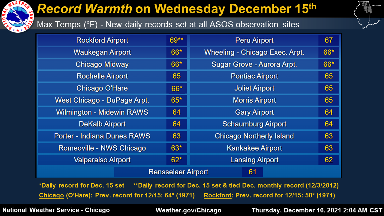 |
| High temperatures (including records set) for Wednesday, December 15 |
Broader Impacts/Additional Info
 |
 |
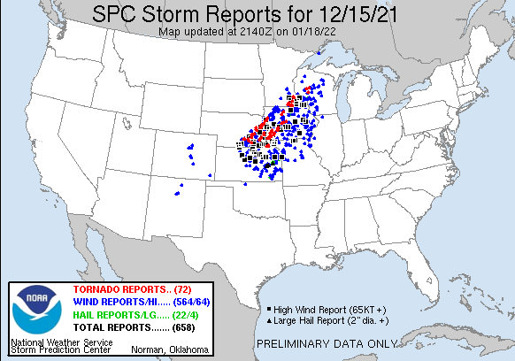 |
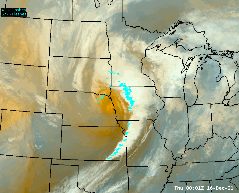
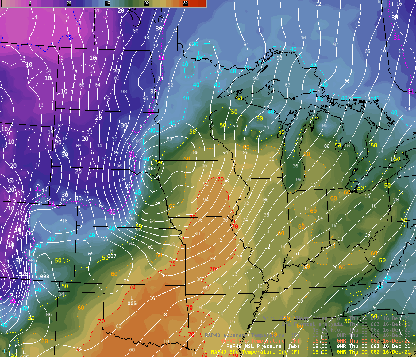
| GOES-16 Water Vapor Imagery | Surface Temperature Map | December 15 Severe Weather Reports |
 |
Media use of NWS Web News Stories is encouraged! Please acknowledge the NWS as the source of any news information accessed from this site. Additional recaps can be found on the NWS Chicago Past Events Page |
|