Record setting heat is expected over the next several days from the Intermountain West through the northern Plains. Furthermore, fire weather concerns increase with dry and breezy conditions. Meanwhile, heavy rainfall and severe thunderstorm threats for the Ohio/Tennessee Valleys, central Appalachians and Southeast today. The threat shifts to central Gulf Coast and across central Texas this week. Read More >
Overview
|
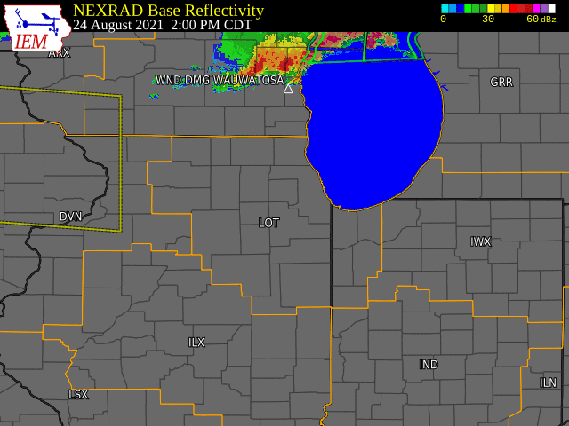
During the late afternoon and evening of August 24th, a line of thunderstorms moved into northwestern Illinois and produced wind damage in the northern part of the state before weakening as it moved into the Chicago metro. Most of this damage was done to trees and power lines and mainly occurred in DeKalb, Ogle, and Winnebago counties, including inside the city of Rockford. Additional thunderstorms developed out ahead of the main line and produced a few instances of wind damage and hail. These storms also produced heavy rainfall with over 2 inches of rain falling in the span of one hour in some locations, resulting in localized flooding in northwest McHenry County and northeast Cook County, including the north side of the city of Chicago. |
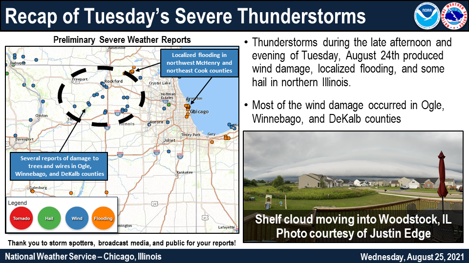 Event Summary Graphic |
Storm Reports
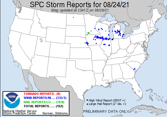 |
| August 24, 2021 Storm Reports |
PRELIMINARY LOCAL STORM REPORT...SUMMARY
NATIONAL WEATHER SERVICE CHICAGO IL
1153 AM CDT WED AUG 25 2021

..TIME...   ...EVENT...      ...CITY LOCATION...     ...LAT.LON...
..DATE...   ....MAG....      ..COUNTY LOCATION..ST.. ...SOURCE....
            ..REMARKS..

0355 PM     MARINE TSTM WIND 2 E WAUKEGAN            42.36N 87.81W
08/24/2021  M42 MPH          LMZ740             IL   C-MAN STATION

            MEASURED AT THE WAUKEGAN HARBOR GLOS
            STATION.

0510 PM     MARINE TSTM WIND 2 NNE EVANSTON          42.07N 87.67W
08/24/2021  M38 MPH          LMZ741             IL   BROADCAST MEDIA

            DELAYED REPORT. MULTIPLE PEOPLE WERE RESCUED
            AFTER 8 SAILBOATS CAPSIZED IN LAKE MICHIGAN
            JUST OFFSHORE FROM EVANSTON. DISPATCH
            RECORDS INDICATE THAT THE INCIDENT OCCURRED
            AT OR JUST BEFORE 5:22 PM. THE NEARBY
            WILMETTE BUOY BEGAN GUSTING TO 38 MPH WITH A
            CHANGE IN WIND DIRECTION FROM EASTERLY TO
            NORTH-NORTHEASTERLY AROUND 5:10 PM.

0510 PM     TSTM WND DMG     1 ENE BLOOMINGDALE      41.96N 88.07W
08/24/2021                   DUPAGE             IL   PUBLIC

            SEVERAL REPORTS OF LARGE TREE LIMBS DOWNED
            IN THE BLOOMINGDALE AREA. TIME ESTIMATED
            FROM RADAR.

0520 PM     HAIL             ELK GROVE VILLAGE       42.01N 87.99W
08/24/2021  M1.00 INCH       COOK               IL   PUBLIC

            PUBLIC SHARED PHOTO VIA SOCIAL MEDIA OF HAIL
            NEAR QUARTER SIZE. TIME ESTIMATED BY RADAR.

0553 PM     TSTM WND DMG     POLO                    41.99N 89.58W
08/24/2021                   OGLE               IL   TRAINED SPOTTER

            TREE DOWNED ONTO A HOUSE. TIME ESTIMATED
            FROM RADAR.

0554 PM     MARINE TSTM WIND HARRISON-DEVER CRIB     41.92N 87.57W
08/24/2021  M47 MPH          LMZ741             IL   C-MAN STATION


0555 PM     TSTM WND DMG     OREGON                  42.01N 89.33W
08/24/2021                   OGLE               IL   TRAINED SPOTTER

            LARGE 3-FT DIAMETER TREE DOWNED AT OGLE
            COUNTY COURTHOUSE. TIME ESTIMATED BY RADAR.

0555 PM     TSTM WND DMG     1 NW OREGON             42.03N 89.35W
08/24/2021                   OGLE               IL   TRAINED SPOTTER

            MULTIPLE 12 TO 18 INCH DIAMETER BRANCHES
            DOWNED IN AND WEST OF OREGON ALONG IL-64.
            TIME ESTIMATED BY RADAR.

0600 PM     TSTM WND DMG     BYRON                   42.13N 89.25W
08/24/2021                   OGLE               IL   PUBLIC

            MULTIPLE PUBLIC REPORTS OF TREE DAMAGE IN
            THE VICINITY OF BYRON AND STILLMAN VALLEY.
            TIME ESTIMATED BY RADAR.

0604 PM     TSTM WND DMG     3 NNW STILLMAN VALLEY   42.14N 89.20W
08/24/2021                   OGLE               IL   AMATEUR RADIO

            SEVERAL LARGE TREE LIMBS SNAPPED. TIME
            ESTIMATED FROM RADAR.

0605 PM     TSTM WND DMG     ROCKFORD                42.27N 89.10W
08/24/2021                   WINNEBAGO          IL   BROADCAST MEDIA

            PHOTO SHARED TO SOCIAL MEDIA SHOWS SMALL
            BRANCHES DOWNED NEAR STATE AND KILBURN IN
            ROCKFORD. TIME ESTIMATED BY RADAR.

0608 PM     TSTM WND DMG     1 WNW ROCKFORD          42.28N 89.12W
08/24/2021                   WINNEBAGO          IL   LAW ENFORCEMENT

            SEVERAL TREES AND WIRES DOWNED ON THE WEST
            SIDE OF ROCKFORD. ONE TREE DOWNED ONTO A
            HOUSE ON ALBERT AVE. TIME ESTIMATED FROM
            RADAR.

0610 PM     TSTM WND GST     1 WNW DAVIS JUNCTION    42.11N 89.11W
08/24/2021  M60 MPH          OGLE               IL   PUBLIC

            REPORT OF MEASURED 60 MPH WIND GUST. RELAYED
            VIA SPOTTERNETWORK.

0612 PM     TSTM WND DMG     2 SE ROCKFORD           42.25N 89.08W
08/24/2021                   WINNEBAGO          IL   LAW ENFORCEMENT

            WIRES DOWNED ON THE 1300 BLOCK OF 9TH ST. IN
            ROCKFORD. TIME ESTIMATED FROM RADAR.

0615 PM     TSTM WND DMG     3 ENE ROCKFORD AIRPORT  42.23N 89.04W
08/24/2021                   WINNEBAGO          IL   AMATEUR RADIO

            4-INCH DIAMETER TREE LIMB DOWNED EAST OF
            SANDY HOLLOW GOLF COURSE IN ROCKFORD. TIME
            ESTIMATED BY RADAR.

0620 PM     TSTM WND DMG     1 S ROCHELLE            41.91N 89.07W
08/24/2021                   OGLE               IL   TRAINED SPOTTER

            TREE BRANCHES AT LEAST 6-INCHES IN DIAMETER
            DOWNED IN SOUTHERN ROCHELLE. TIME ESTIMATED
            BY RADAR.

0628 PM     TSTM WND DMG     1 ENE ROCHELLE          41.93N 89.06W
08/24/2021                   OGLE               IL   PUBLIC

            PUBLIC REPORTS SMALL BRANCHES DOWNED IN
            ROCHELLE AREA. REPORT RELAYED VIA MPING.

0630 PM     TSTM WND DMG     1 W EDGEWATER - CHICAGO 41.99N 87.67W
08/24/2021                   COOK               IL   PUBLIC

            VIDEO SHARED TO SOCIAL MEDIA SHOWS SEVERAL
            LARGE BRANCHES DOWNED AND A TREE UPROOTED
            ALONG RAVENSWOOD AVENUE. TIME ESTIMATED FROM
            RADAR.

0635 PM     TSTM WND DMG     KINGSTON                42.10N 88.75W
08/24/2021                   DE KALB            IL   PUBLIC

            PUBLIC REPORT OF NUMEROUS BRANCHES DOWNED IN
            KINGSTON. TIME ESTIMATED BY RADAR.

0640 PM     TSTM WND DMG     1 NW DEKALB             41.95N 88.77W
08/24/2021                   DE KALB            IL   PUBLIC

            PHOTO SHARED TO SOCIAL MEDIA SHOWS MULTIPLE
            BRANCHES UP TO 8-IN DIAMETER DOWNED NEAR
            HILLCREST DRIVE AND BLACKHAWK ROAD IN
            DEKALB. TIME ESTIMATED BY RADAR.

0640 PM     TSTM WND DMG     1 W DEKALB              41.93N 88.77W
08/24/2021                   DE KALB            IL   PUBLIC

            PHOTO SHARED VIA SOCIAL MEDIA SHOWS TREE
            SNAPPED NEAR THE BASE NEAR NORTHERN ILLINOIS
            UNIVERSITY IN DEKALB. TIME ESTIMATED BY
            RADAR.

0643 PM     TSTM WND DMG     GENOA                   42.10N 88.69W
08/24/2021                   DE KALB            IL   PUBLIC

            WIRES DOWNED IN GENOA. TIME ESTIMATED FROM
            RADAR.

0645 PM     TSTM WND GST     2 ENE DEKALB            41.94N 88.72W
08/24/2021  M68 MPH          DE KALB            IL   PUBLIC

            68 MPH WIND GUST MEASURED BY HANDHELD
            ANEMOMETER NEAR DEKALB AIRPORT. TIME
            ESTIMATED BY RADAR.

0645 PM     FLASH FLOOD      HARVARD                 42.43N 88.61W
08/24/2021                   MCHENRY            IL   EMERGENCY MNGR

            DELAYED REPORT OF ONE CAR STALLED DUE TO
            FLOODWATERS ON MCKINLEY STREET IN HARVARD.
            TIME ESTIMATED.

0645 PM     TSTM WND DMG     SYCAMORE                41.99N 88.69W
08/24/2021                   DE KALB            IL   TRAINED SPOTTER

            2-3 INCH DIAMETER TREE BRANCHES DOWNED IN
            SYCAMORE. TIME ESTIMATED BY RADAR.

0655 PM     TSTM WND GST     3 NNW WOODSTOCK         42.35N 88.47W
08/24/2021  M52 MPH          MCHENRY            IL   LAW ENFORCEMENT

            52 MPH WIND GUST JUST NORTHWEST OF WOODSTOCK
            MEASURED WITH A HANDHELD ANEMOMETER.

0655 PM     MARINE TSTM WIND MICHIGAN CITY BUOY      41.76N 86.97W
08/24/2021  M49 MPH          LMZ745             IN   BUOY

            MEASURED AT THE MICHIGAN CITY BUOY (45170).

0700 PM     FLASH FLOOD      1 NNE UPTOWN - CHICAGO  41.98N 87.65W
08/24/2021                   COOK               IL   PUBLIC

            UPDATE TO PREVIOUS FLOOD REPORT FROM 1 NNE
            UPTOWN - CHICAGO. MULTIPLE PHOTOS AND VIDEOS
            SHARED TO SOCIAL MEDIA SHOW FLOODING OF
            DUSABLE LAKE SHORE DRIVE AT UNDERPASSES.
            REVIEW OF ADDITIONAL INFORMATION CAUSED THIS
            REPORT TO BE CHANGED TO FLASH FLOODING.

0709 PM     FLOOD            EDGEWATER - CHICAGO     41.98N 87.67W
08/24/2021                   COOK               IL   PUBLIC

            PHOTO SHARED VIA SOCIAL MEDIA SHOWS SEVERAL
            INCHES OF STANDING WATER ON RESIDENTIAL
            STREET IN ANDERSONVILLE, CHICAGO.

0717 PM     TSTM WND DMG     AURORA                  41.76N 88.32W
08/24/2021                   KANE               IL   EMERGENCY MNGR

            MULTIPLE REPORTS OF TREES AND WIRES DOWNED
            IN AURORA.

0722 PM     FLOOD            1 NE NORTH CENTER - CHI 41.95N 87.67W
08/24/2021                   COOK               IL   PUBLIC

            VIDEOS SHARED TO SOCIAL MEDIA SHOW SEVERAL
            INCHES OF WATER AT IRVING PARK ROAD
            UNDERPASS AT RAVENSWOOD AVENUE.

0728 PM     MARINE TSTM WIND 3 SE MICHIGAN CITY BUOY 41.73N 86.93W
08/24/2021  M54 MPH          LMZ745             IN   C-MAN STATION

            MEASURED AT THE MICHIGAN CITY C-MAN.

0730 PM     FLOOD            2 WNW CHICAGO LOOP      41.89N 87.67W
08/24/2021                   COOK               IL   BROADCAST MEDIA

            DELAYED REPORT. REPORT OF A STALLED CAR AT
            UNDERPASS NEAR ASHLAND AVENUE AND KINZIE
            STREET. TIME ESTIMATED.

0736 PM     TSTM WND DMG     DOWNERS GROVE           41.79N 88.01W
08/24/2021                   DUPAGE             IL   NWS EMPLOYEE

            TWO ROUGHLY 6 INCH DIAMETER TREE LIMBS DOWN
            ON MAPLE AVENUE. TIME ESTIMATED BASED ON
            RADAR.

0754 PM     TSTM WND GST     MANHATTAN               41.42N 87.99W
08/24/2021  E50 MPH          WILL               IL   EMERGENCY MNGR

            REPORT RELAYED FOR A FEW SMALL BRANCHES
            BROKEN. TIME ESTIMATED BASED ON RADAR.

0814 PM     HEAVY RAIN       1 ENE LINCOLN SQUARE -  41.98N 87.68W
08/24/2021  M2.74 INCH       COOK               IL   MESONET

            STORM TOTAL. 2.27 INCHES FELL OVER A ONE
            HOUR PERIOD BETWEEN 5:49 AND 6:49 PM.
            PERSONAL WEATHER STATION KILCHICA440.

0820 PM     FLASH FLOOD      1 E NORTH LAWNDALE - CH 41.86N 87.69W
08/24/2021                   COOK               IL   BROADCAST MEDIA

            DELAYED REPORT. REPORT OF CARS STALLED IN
            WATER NEAR OGDEN AVENUE AND WESTERN AVENUE.
            TIME ESTIMATED.

0917 PM     HEAVY RAIN       1 ESE HARVARD           42.42N 88.60W
08/24/2021  M2.06 INCH       MCHENRY            IL   MESONET

            STORM TOTAL. 1.49 INCHES FELL OVER A ONE
            HOUR PERIOD BETWEEN 6:14 AND 7:14 PM.
            PERSONAL WEATHER STATION KILHARVA3.

1009 PM     HEAVY RAIN       1 WSW EDGEWATER - CHICA 41.98N 87.67W
08/24/2021  M2.61 INCH       COOK               IL   MESONET

            STORM TOTAL. 2.16 INCHES FELL OVER A ONE
            HOUR PERIOD BETWEEN 5:49 AND 6:49 PM.
            PERSONAL WEATHER STATION KILCHICA855.

1014 PM     HEAVY RAIN       EDGEWATER - CHICAGO     41.99N 87.66W
08/24/2021  M3.24 INCH       COOK               IL   MESONET

            STORM TOTAL. 2.90 INCHES FELL OVER A ONE
            HOUR PERIOD BETWEEN 5:49 AND 6:49 PM.
            PERSONAL WEATHER STATION KILCHICA814.

0147 AM     HEAVY RAIN       3 SE CHESTERTON         41.59N 87.03W
08/25/2021  M2.97 INCH       PORTER             IN   MESONET

            STORM TOTAL. 2.02 INCHES FELL OVER A ONE
            HOUR PERIOD BETWEEN 8:01 AND 9:01 PM.
            MESONET STATION FW7961 CHESTERTON.

0355 AM     HEAVY RAIN       HOBART                  41.54N 87.26W
08/25/2021  M2.25 INCH       LAKE               IN   MESONET

            STORM TOTAL. 1.87 INCHES FELL OVER A ONE
            HOUR PERIOD BETWEEN 8:00 AND 9:00 PM. USGS
            413218087151701 - HOBART PRECIP STATION.

0630 AM     HEAVY RAIN       2 E CHESTERTON          41.61N 87.03W
08/25/2021  M2.76 INCH       PORTER             IN   COCORAHS

            STORM TOTAL. COCORAHS STATION IN-PT-110
            CHESTERTON 2 E.

0700 AM     HEAVY RAIN       4 NNE HARVARD           42.48N 88.58W
08/25/2021  M4.14 INCH       MCHENRY            IL   COCORAHS

            STORM TOTAL. COCORAHS STATION IL-MCH-103
            HARVARD 4.4 NNE.

0700 AM     HEAVY RAIN       5 ESE CHESTERTON        41.59N 86.98W
08/25/2021  M3.25 INCH       PORTER             IN   COCORAHS

            STORM TOTAL. COCORAHS STATION IN-PT-91
            CHESTERTON 5 ESE.

0700 AM     HEAVY RAIN       WEST RIDGE - CHICAGO    42.00N 87.70W
08/25/2021  M2.59 INCH       COOK               IL   COCORAHS

            STORM TOTAL. COCORAHS STATION IL-CK-94
            CHICAGO - WEST RIDGE.

0700 AM     HEAVY RAIN       1 WSW HARVARD           42.42N 88.63W
08/25/2021  M2.55 INCH       MCHENRY            IL   CO-OP OBSERVER

            STORM TOTAL. CO-OP OBSERVER STATION HVDI2
            HARVARD.

0700 AM     HEAVY RAIN       CAPRON                  42.40N 88.74W
08/25/2021  M2.50 INCH       BOONE              IL   COCORAHS

            STORM TOTAL. COCORAHS STATION IL-BN-14
            CAPRON.

0800 AM     HEAVY RAIN       ROGERS PARK - CHICAGO   42.00N 87.67W
08/25/2021  M2.57 INCH       COOK               IL   COCORAHS

            STORM TOTAL. COCORAHS STATION IL-CK-232
            CHICAGO - ROGERS PARK.
Rain Reports
COCORAHS PRECIPITATION SUMMARY
NATIONAL WEATHER SERVICE CHICAGO IL
1000 AM CDT WED AUG 25 2021

COCORAHS PRECIPITATION REPORTS
THESE REPORTS ARE CONSIDERED SUPPLEMENTAL AND UNOFFICIAL
VALUES ARE FOR THE PREVIOUS 24 HOURS ENDING AROUND 7 AM LOCAL TIME


:COCORAHS PRECIPITATION REPORTS IN ILLINOIS

:                                               SNOW   SNOW  WATER
:                                        PCPN   FALL  DEPTH  EQUIV

IL-MCH-103: HARVARD 4.4 NNE          *   : 4.14 /  MM /   MM /   MM
IL-CK-94  : LINCOLNWOOD 1.8 E        *   : 2.59 /  MM /   MM /   MM
IL-CK-232 : ROGERS PARK 0.6 ESE      *   : 2.57 /  MM /   MM /   MM
IL-BN-14  : CAPRON 0.1 N             *   : 2.50 /  MM /   MM /   MM
IL-CK-168 : RAVENSWOOD MANOR 0.1 ESE *   : 2.33 /  MM /   MM /   MM
IL-CK-285 : HARWOOD HEIGHTS 0.4 NNE  *   : 2.15 /  MM /   MM /   MM
IL-CK-214 : ROGERS PARK 1.5 SW       *   : 2.10 /  MM /   MM /   MM
IL-CK-180 : PARK RIDGE 0.5 SSW       *   : 1.51 /  MM /   MM /   MM
IL-CK-321 : EVANSTON 0.9 S           *   : 1.43 /  MM /   MM /   MM
IL-LS-45  : STREATOR 1.3 WSW         *   : 1.43 /  MM /   MM /   MM
IL-LV-21  : CHATSWORTH 1.2 S         *   : 1.35 /  MM /   MM /   MM
IL-CK-334 : EVANSTON 0.6 S           *   : 1.29 /  MM /   MM /   MM
IL-CK-336 : EVANSTON 0.8 ESE         *   : 1.28 / 0.0 /  0.0 / 0.00
IL-CK-229 : FLOSSMOOR 1.2 ESE        *   : 1.27 /  MM /   MM /   MM
IL-IR-20  : CHEBANSE 0.6 SSW         *   : 1.26 /  MM /   MM /   MM
IL-KK-28  : CHEBANSE 0.4 NNE         *   : 1.25 /  MM /   MM /   MM
IL-CK-63  : ELK GROVE VILLAGE 0.6 ESE*   : 1.17 /  MM /   MM /   MM
IL-KK-42  : CHEBANSE 0.8 ENE         *   : 1.17 /  MM /   MM /   MM
IL-CK-192 : PARK RIDGE 0.7 WNW       *   : 1.13 /  MM /   MM /   MM
IL-IR-22  : CHEBANSE 1.6 SW          *   : 1.12 /  MM /   MM /   MM
IL-DP-155 : MEDINAH 1.0 SSW          *   : 1.11 / 0.0 /  0.0 / 0.00
IL-IR-21  : CLIFTON 0.5 WNW          *   : 1.10 /  MM /   MM /   MM
IL-CK-74  : OAK PARK 1.3 NNE         *   : 1.07 / 0.0 /   MM /   MM
IL-CK-366 : OAK PARK 1.0 NNE         *   : 1.03 /  MM /   MM /   MM
IL-WL-25  : CRETE 2.6 E              *   : 1.01 /  MM /   MM /   MM
IL-LK-9   : LAKE VILLA 1.1 SSW       *   : 0.98 /  MM /   MM /   MM
IL-LK-114 : ROUND LAKE HEIGHTS 0.5 NE*   : 0.95 /  MM /   MM /   MM
IL-CK-14  : CHICAGO 5.5 ESE          *   : 0.95 /  MM /   MM /   MM
IL-KK-39  : HERSCHER 3.3 E           *   : 0.92 / 0.0 /  0.0 /   MM
IL-CK-323 : CHICAGO 6.8 NW           *   : 0.89 /  MM /   MM /   MM
IL-WL-23  : BEECHER 3.4 SSE          *   : 0.88 /  MM /   MM /   MM
IL-LK-112 : LINDENHURST 1.0 ENE      *   : 0.88 /  MM /   MM /   MM
IL-DP-150 : BLOOMINGDALE 1.2 ESE     *   : 0.87 /  MM /   MM /   MM
IL-GY-16  : MORRIS 6.4 ESE           *   : 0.84 /  MM /   MM /   MM
IL-CK-345 : FRANKLIN PARK 0.5 SSE    *   : 0.84 /  MM /   MM /   MM
IL-GY-1   : CARBON HILL 3.1 N        *   : 0.83 / 0.0 /  0.0 /   MM
IL-WN-50  : ROCKTON 3.1 SW           *   : 0.81 / 0.0 /  0.0 /   MM
IL-WL-20  : MANHATTAN 4.7 ENE        *   : 0.81 / 0.0 /  0.0 /   MM
IL-CK-325 : MOUNT PROSPECT 1.3 SSE   *   : 0.80 /  MM /   MM /   MM
IL-DP-174 : BOLINGBROOK 2.6 NE       *   : 0.79 /  MM /   MM /   MM
IL-GY-28  : MORRIS 1.5 SW            *   : 0.79 /  MM /   MM /   MM
IL-WL-84  : BEECHER 3.4 ENE          *   : 0.77 /  MM /   MM /   MM
IL-WL-149 : BULT FIELD-MONEE 4.9 SE  *   : 0.77 / 0.0 /  0.0 /   MM
IL-LK-100 : LONG LAKE 0.4 S          *   : 0.76 /  MM /   MM /   MM
IL-LS-50  : SENECA 1.2 NNE           *   : 0.75 /  MM /   MM /   MM
IL-GY-37  : MAZON 2.4 SE             *   : 0.75 /  MM /   MM /   MM
IL-GY-20  : MORRIS 2.5 SSE           *   : 0.75 /  MM /   MM /   MM
IL-LK-23  : WINTHROP HARBOR 0.2 SSE  *   : 0.75 /  MM /   MM /   MM
IL-IR-10  : BUCKLEY 0.2 SSE          *   : 0.74 /  MM /   MM /   MM
IL-KK-21  : MANTENO 2.2 SSE          *   : 0.73 /  MM /   MM /   MM
IL-WL-166 : NAPERVILLE 3.6 SE        *   : 0.72 /  MM /   MM /   MM
IL-DP-42  : CAROL STREAM 0.3 SSE     *   : 0.72 /  MM /   MM /   MM
IL-DP-117 : ELMHURST 2.0 SE          *   : 0.71 /  MM /   MM /   MM
IL-GY-11  : MORRIS 4.8 NNW           *   : 0.71 /  MM /   MM /   MM
IL-MCH-87 : MARENGO 0.7 NNW          *   : 0.70 /  MM /   MM /   MM
IL-GY-27  : MORRIS 5.9 ESE           *   : 0.69 /  MM /   MM /   MM
IL-DP-102 : BOLINGBROOK 2.7 NE       *   : 0.68 /  MM /   MM /   MM
IL-CK-12  : BRIDGEVIEW 1.3 NNW       *   : 0.65 /  MM /   MM /   MM
IL-CK-53  : GLENCOE 0.1 NW           *   : 0.65 /  MM /   MM /   MM
IL-CK-131 : SCHAUMBURG 2.0 E         *   : 0.65 /  MM /   MM /   MM
IL-CK-331 : NORTHFIELD 0.3 S         *   : 0.64 /  MM /   MM /   MM
IL-DP-85  : VILLA PARK 1.0 NW        *   : 0.64 /  MM /   MM /   MM
IL-LK-27  : WINTHROP HARBOR 0.7 SSW  *   : 0.64 /  MM /   MM /   MM
IL-LV-20  : CROPSEY 1.0 NE           *   : 0.63 /  MM /   MM /   MM
IL-CK-193 : WINNETKA 0.8 ESE         *   : 0.63 /  MM /   MM /   MM
IL-CK-163 : ARLINGTON HEIGHTS 1.2 SW *   : 0.63 /  MM /   MM /   MM
IL-WN-41  : SOUTH BELOIT 1.5 ESE     *   : 0.62 /  MM /   MM /   MM
IL-IR-14  : WATSEKA 6.9 WNW          *   : 0.60 /  MM /   MM /   MM
IL-CK-347 : STREAMWOOD 1.1 WSW       *   : 0.60 /  MM /   MM /   MM
IL-LK-81  : LAKE VILLA 2.3 WSW       *   : 0.60 /  MM /   MM /   MM
IL-CK-253 : MIDLOTHIAN 0.1 SSE       *   : 0.58 /  MM /   MM /   MM
IL-MCH-85 : LAKE IN THE HILLS 2.5 W  *   : 0.58 /  MM /   MM /   MM
IL-LS-34  : LA SALLE 0.1 W           *   : 0.58 /  MM /   MM /   MM
IL-WN-10  : NEW MILLFORD 3.3 W       *   : 0.58 / 0.0 /  0.0 /   MM
IL-CK-322 : ARLINGTON HEIGHTS 0.8 NNW*   : 0.57 /  MM /   MM /   MM
IL-FD-10  : GIBSON CITY 6.5 NE       *   : 0.55 /  MM /   MM /   MM
IL-LS-60  : PERU 0.7 ENE             *   : 0.55 /  MM /   MM /   MM
IL-LS-12  : PERU 0.6 SW              *   : 0.54 /  MM /   MM /   MM
IL-MCH-43 : ALGONQUIN 0.7 N          *   : 0.53 / 0.0 /  0.0 / 0.00
IL-CK-326 : MORTON GROVE 1.2 WNW     *   : 0.53 /  MM /   MM /   MM
IL-KK-45  : KANKAKEE 1.4 WSW         *   : 0.53 /  MM /   MM /   MM
IL-CK-75  : ELK GROVE VILLAGE 2.2 WSW*   : 0.52 /  MM /   MM /   MM
IL-GY-34  : MORRIS 4.5 NW            *   : 0.51 /  MM /   MM /   MM
IL-KK-40  : ST ANNE 3.2 NNE          *   : 0.50 /  MM /   MM /   MM
IL-CK-342 : MERRIONETTE PARK 1.7 NE  *   : 0.50 /  MM /   MM /   MM
IL-MCH-13 : BULL VALLEY 2.5 WNW      *   : 0.50 / 0.0 /  0.0 / 0.00
IL-WL-105 : PLAINFIELD 2.9 NNW       *   : 0.50 /  MM /   MM /   MM
IL-GY-10  : MINOOKA 0.3 NE           *   : 0.49 /  MM /   MM /   MM
IL-IR-16  : CISSNA PARK 0.6 S        *   : 0.49 /  MM /   MM /   MM
IL-IR-2   : ASHKUM 5.6 E             *   : 0.48 /  MM /   MM /   MM
IL-DP-122 : CLARENDON HILLS 0.5 NW   *   : 0.48 /  MM /   MM /   MM
IL-LS-1   : OTTAWA 1.3 NW            *   : 0.48 /  MM /   MM /   MM
IL-LS-66  : MARSEILLES 3.0 WSW       *   : 0.48 /  MM /   MM /   MM
IL-LK-26  : ZION 0.5 WNW             *   : 0.48 /  MM /   MM /   MM
IL-KN-9   : ELGIN 1.0 S              *   : 0.47 / 0.0 /  0.0 /   MM
IL-KN-95  : ELGIN 2.5 W              *   : 0.46 / 0.0 /   MM /   MM
IL-WN-45  : MACHESNEY PARK 0.9 W     *   : 0.46 /  MM /   MM /   MM
IL-DP-79  : BURR RIDGE 1.9 SW        *   : 0.45 /  MM /   MM /   MM
IL-WL-79  : PEOTONE 0.5 SE           *   : 0.45 /  MM /   MM /   MM
IL-CK-145 : OAK PARK 1.5 S           *   : 0.44 /  MM /   MM /   MM
IL-MCH-101: CRYSTAL LAKE 1.9 SW      *   : 0.44 /  MM /   MM /   MM
IL-WN-40  : ROCKFORD 4.5 WSW         *   : 0.44 /  MM /   MM /   MM
IL-KN-2   : ELGIN 2.3 WNW            *   : 0.44 /  MM /   MM /   MM
IL-WL-92  : NAPERVILLE 4.0 SSW       *   : 0.44 /  MM /   MM /   MM
IL-WL-42  : MOKENA 1.3 W             *   : 0.43 /  MM /   MM /   MM
IL-MCH-33 : WOODSTOCK 3.8 SW         *   : 0.43 /  MM /   MM /   MM
IL-WL-67  : CHANNAHON 2.5 SSE        *   : 0.43 /  MM /   MM /   MM
IL-LS-39  : OTTAWA 0.5 NNW           *   : 0.42 /  MM /   MM /   MM
IL-CK-277 : OAK FOREST 0.6 SSE       *   : 0.42 /  MM /   MM /   MM
IL-WN-44  : WINNEBAGO 5.4 SE         *   : 0.42 /  MM /   MM /   MM
IL-CK-306 : OAK FOREST 0.6 N         *   : 0.42 / 0.0 /  0.0 /   MM
IL-WL-46  : PEOTONE 0.4 ENE          *   : 0.41 /  MM /   MM /   MM
IL-WL-80  : LOCKPORT 1.3 SE          *   : 0.41 /  MM /   MM /   MM
IL-CK-148 : OAK LAWN 1.9 SE          *   : 0.41 /  MM /   MM /   MM
IL-KN-22  : GENEVA 1.0 SSW           *   : 0.40 /  MM /   MM /   MM
IL-LS-17  : OTTAWA 1.6 N             *   : 0.40 / 0.0 /   MM /   MM
IL-LK-120 : WADSWORTH 1.4 S          *   : 0.40 /  MM /   MM /   MM
IL-KN-23  : BATAVIA 1.5 WNW          *   : 0.39 /  MM /   MM /   MM
IL-CK-361 : GLENVIEW 0.7 SE          *   : 0.39 /  MM /   MM /   MM
IL-DP-100 : BARTLETT 1.1 SE          *   : 0.39 /  MM /   MM /   MM
IL-WN-43  : ROCKFORD 3.8 S           *   : 0.39 /  MM /   MM /   MM
IL-WL-61  : CHANNAHON 0.8 NNE        *   : 0.39 /  MM /   MM /   MM
IL-DP-141 : GLEN ELLYN 1.1 WSW       *   : 0.39 /  MM /   MM /   MM
IL-CK-211 : OAK LAWN 1.6 WNW         *   : 0.38 /  MM /   MM /   MM
IL-CK-317 : HOFFMAN ESTATES 0.6 ESE  *   : 0.38 /  MM /   MM /   MM
IL-LK-69  : HIGHWOOD 0.9 S           *   : 0.37 / 0.0 /  0.0 /   MM
IL-CK-61  : OAK PARK 1.0 SW          *   : 0.37 /  MM /   MM /   MM
IL-LS-49  : NORTH UTICA 6.3 N        *   : 0.37 /  MM /   MM /   MM
IL-DP-38  : ELMHURST 0.4 SW          *   : 0.37 /  MM /   MM /   MM
IL-KN-118 : SLEEPY HOLLOW 0.7 W      *   : 0.37 /  MM /   MM /   MM
IL-WL-173 : LOCKPORT 5.0 W           *   : 0.36 /  MM /   MM /   MM
IL-LE-23  : SUBLETTE 3.1 WNW         *   : 0.36 / 0.0 /  0.0 / 0.00
IL-WL-99  : MANHATTAN 1.9 SE         *   : 0.35 /  MM /   MM /   MM
IL-CK-367 : MOUNT PROSPECT 0.2 NNE   *   : 0.35 /  MM /   MM /   MM
IL-DP-156 : NAPERVILLE 0.5 NW        *   : 0.35 /  MM /   MM /   MM
IL-MCH-95 : CARY 0.5 SSW             *   : 0.35 /  MM /   MM /   MM
IL-LS-57  : MENDOTA 0.4 ENE          *   : 0.35 /  MM /   MM /   MM
IL-WL-96  : WILMINGTON 6.3 NW        *   : 0.35 /  MM /   MM /   MM
IL-FD-9   : GIBSON CITY 3.0 WNW      *   : 0.34 /  MM /   MM /   MM
IL-DP-40  : LOMBARD 1.0 NNW          *   : 0.34 /  MM /   MM /   MM
IL-LE-10  : DIXON 3.0 NNW            *   : 0.34 /  MM /   MM /   MM
IL-WL-164 : WILMINGTON 0.9 ENE       *   : 0.34 /  MM /   MM /   MM
IL-MCH-83 : CRYSTAL LAKE 1.0 WSW     *   : 0.34 /  MM /   MM /   MM
IL-WN-48  : ROCKFORD 3.8 NNW         *   : 0.33 /  MM /   MM /   MM
IL-CK-106 : HOFFMAN ESTATES 4.6 W    *   : 0.33 /  MM /   MM /   MM
IL-CK-320 : PARK FOREST 0.7 WNW      *   : 0.33 /  MM /   MM /   MM
IL-CK-278 : HOFFMAN ESTATES 1.6 SE   *   : 0.33 /  MM /   MM /   MM
IL-KN-5   : BATAVIA 0.7 WSW          *   : 0.33 / 0.0 /  0.0 /   MM
IL-KD-24  : OSWEGO 5.0 SSE           *   : 0.33 /  MM /   MM /   MM
IL-WL-142 : MOKENA 3.4 WNW           *   : 0.33 /  MM /   MM /   MM
IL-KD-107 : YORKVILLE 2.1 NNW        *   : 0.33 /  MM /   MM /   MM
IL-KN-127 : GENEVA 0.6 SSE           *   : 0.32 /  MM /   MM /   MM
IL-CK-294 : PALATINE 1.4 NNE         *   : 0.32 /  MM /   MM /   MM
IL-CK-69  : PARK FOREST 0.8 NNE      *   : 0.32 /  MM /   MM /   MM
IL-MCH-35 : LAKEMOOR 1.9 NW          *   : 0.32 /  MM /   MM /   MM
IL-MCH-49 : CARY 0.3 NE              *   : 0.32 /  MM /   MM /   MM
IL-LE-8   : ASHTON 0.4 SSW           *   : 0.31 / 0.0 /  0.0 / 0.00
IL-LK-16  : BUFFALO GROVE 1.5 N      *   : 0.31 /  MM /   MM /   MM
IL-KD-34  : PLAINFIELD 4.8 SW        *   : 0.31 / 0.0 /  0.0 /   MM
IL-MCH-94 : MCHENRY 2.4 E            *   : 0.31 /  MM /   MM /   MM
IL-MCH-93 : MARENGO 0.8 S            *   : 0.31 /  MM /   MM /   MM
IL-MCH-96 : HUNTLEY 1.6 SW           *   : 0.30 /  MM /   MM /   MM
IL-LK-15  : BANNOCKBURN 0.5 ESE      *   : 0.30 /  MM /   MM /   MM
IL-LK-18  : GRAYSLAKE 0.7 WSW        *   : 0.30 /  MM /   MM /   MM
IL-CK-364 : EVERGREEN PARK 0.4 WNW   *   : 0.30 /  MM /   MM /   MM
IL-DK-39  : LEE 2.7 NNE              *   : 0.29 /  MM /   MM /   MM
IL-KD-102 : OSWEGO 2.4 SSW           *   : 0.29 / 0.0 /  0.0 /   MM
IL-DP-163 : LOMBARD 1.2 E            *   : 0.29 /  MM /   MM /   MM
IL-WL-100 : JOLIET 2.9 WNW           *   : 0.28 /  MM /   MM /   MM
IL-DP-118 : DARIEN 0.4 SSE           *   : 0.28 /  MM /   MM /   MM
IL-DP-132 : WHEATON 2.0 NNE          *   : 0.28 / 0.0 /  0.0 / 0.00
IL-KD-106 : YORKVILLE 2.8 NE         *   : 0.28 /  MM /   MM /   MM
IL-WN-26  : ROCKFORD 1.5 ENE         *   : 0.28 /  MM /   MM /   MM
IL-WL-72  : NEW LENOX 2.9 ENE        *   : 0.28 /  MM /   MM /   MM
IL-IR-24  : CLIFTON 3.9 ESE          *   : 0.27 /  MM /   MM /   MM
IL-CK-149 : OAK LAWN 0.5 SSW         *   : 0.27 /  MM /   MM /   MM
IL-KN-129 : ELGIN 5.8 WNW            *   : 0.27 /  MM /   MM /   MM
IL-WN-52  : LOVES PARK 2.5 SSE       *   : 0.26 /  MM /   MM /   MM
IL-WL-16  : HOMER GLEN 0.8 ENE       *   : 0.26 /  MM /   MM /   MM
IL-WL-73  : WILMINGTON 2.6 SE        *   : 0.26 /  MM /   MM /   MM
IL-KD-111 : YORKVILLE 3.1 N          *   : 0.26 /  MM /   MM /   MM
IL-KD-123 : AURORA 4.1 SSE           *   : 0.25 /  MM /   MM /   MM
IL-WL-97  : NEW LENOX 3.3 E          *   : 0.25 / 0.0 /  0.0 / 0.00
IL-CK-121 : PALATINE 1.3 E           *   : 0.24 / 0.0 /  0.0 /   MM
IL-DK-36  : DE KALB 3.5 WSW          *   : 0.24 /  MM /   MM /   MM
IL-KN-104 : GENEVA 3.9 WSW           *   : 0.24 / 0.0 /  0.0 / 0.00
IL-KN-135 : BATAVIA 0.8 W            *   : 0.23 /  MM /   MM /   MM
IL-CK-88  : COUNTRYSIDE 0.8 ENE      *   : 0.23 /  MM /   MM /   MM
IL-LE-22  : AMBOY 0.5 SSW            *   : 0.23 / 0.0 /  0.0 / 0.00
IL-CK-98  : LA GRANGE PARK 0.7 SSW   *   : 0.23 /  MM /   MM /   MM
IL-IR-25  : MILFORD 3.5 ENE          *   : 0.22 /  MM /   MM /   MM
IL-KD-109 : YORKVILLE 1.0 N          *   : 0.22 /  MM /   MM /   MM
IL-WL-131 : HOMER GLEN 0.7 NNE       *   : 0.22 /  MM /   MM /   MM
IL-KN-86  : ELGIN 7.5 WSW            *   : 0.22 /  MM /   MM /   MM
IL-WL-121 : MONEE 4.9 W              *   : 0.22 /  MM /   MM /   MM
IL-KN-98  : GILBERTS 0.5 N           *   : 0.21 /  MM /   MM /   MM
IL-DP-164 : WEST CHICAGO 3.5 SE      *   : 0.20 /  MM /   MM /   MM
IL-KD-110 : YORKVILLE 0.9 SSW        *   : 0.20 /  MM /   MM /   MM
IL-CK-316 : OAK LAWN 0.8 WSW         *   : 0.19 /  MM /   MM /   MM
IL-LK-42  : GURNEE 1.6 W             *   : 0.19 /  MM /   MM /   MM
IL-LK-121 : LIBERTYVILLE 0.4 ESE     *   : 0.19 /  MM /   MM /   MM
IL-WL-172 : JOLIET 2.0 WNW           *   : 0.19 /  MM /   MM /   MM
IL-BN-19  : BELVIDERE 5.0 NNW        *   : 0.19 /  MM /   MM /   MM
IL-LE-5   : STERLING 4.3 NE          *   : 0.19 /  MM /   MM /   MM
IL-KN-121 : GENEVA 1.3 NW            *   : 0.18 / 0.0 /  0.0 / 0.00
IL-KN-51  : SUGAR GROVE 1.4 ENE      *   : 0.18 /  MM /   MM /   MM
IL-CK-152 : CHICAGO RIDGE 0.2 WSW    *   : 0.18 / 0.0 /   MM /   MM
IL-LK-103 : BUFFALO GROVE 1.3 ESE    *   : 0.17 /  MM /   MM /   MM
IL-DP-157 : WEST CHICAGO 3.5 NNE     *   : 0.17 /  MM /   MM /   MM
IL-KN-67  : ST. CHARLES 6.0 NW       *   : 0.17 / 0.0 /  0.0 /   MM
IL-DK-5   : CORTLAND 0.3 SSW         *   : 0.16 /  MM /   MM /   MM
IL-KN-133 : GENEVA 0.9 E             *   : 0.16 /  MM /   MM /   MM
IL-CK-346 : PALATINE 1.2 NW          *   : 0.16 /  MM /   MM /   MM
IL-WL-63  : NEW LENOX 1.8 SE         *   : 0.16 /  MM /   MM /   MM
IL-CK-50  : PALOS PARK 1.3 SW        *   : 0.16 /  MM /   MM /   MM
IL-DK-28  : DE KALB 0.7 SW           *   : 0.15 / 0.0 /  0.0 / 0.00
IL-LK-54  : MUNDELEIN 0.5 NNE        *   : 0.15 /  MM /   MM /   MM
IL-DP-57  : AURORA 3.5 NE            *   : 0.15 /  MM /   MM /   MM
IL-KD-7   : PLANO 0.4 NNE            *   : 0.14 /  MM /   MM /   MM
IL-WL-58  : PLAINFIELD 3.0 ESE       *   : 0.14 /  MM /   MM /   MM
IL-LK-119 : LAKE ZURICH 1.4 W        *   : 0.13 /  MM /   MM /   MM
IL-DK-27  : KINGSTON 2.3 WNW         *   : 0.13 /  MM /   MM /   MM
IL-DK-38  : CORTLAND 0.3 E           *   : 0.13 /  MM /   MM /   MM
IL-KN-4   : SUGAR GROVE 0.7 NE       *   : 0.13 /  MM /   MM /   MM
IL-KD-99  : MONTGOMERY 3.5 WSW       *   : 0.12 /  MM /   MM /   MM
IL-KN-130 : ST. CHARLES 0.2 NNW      *   : 0.12 /  MM /   MM /   MM
IL-KN-64  : ST. CHARLES 0.1 E        *   : 0.11 / 0.0 /  0.0 /   MM
IL-WL-51  : PLAINFIELD 2.4 SSE       *   : 0.11 /  MM /   MM /   MM
IL-LK-19  : WAUKEGAN 2.2 N           *   : 0.10 /  MM /   MM /   MM
IL-LK-87  : LAKE ZURICH 1.3 N        *   : 0.10 /  MM /   MM /   MM
IL-DP-176 : WINFIELD 0.6 SSW         *   : 0.10 /  MM /   MM /   MM
IL-LE-25  : DIXON 0.8 NE             *   : 0.10 /  MM /   MM /   MM
IL-KN-123 : AURORA 2.8 WSW           *   : 0.09 / 0.0 /   MM /   MM
IL-KN-128 : BATAVIA 3.4 WSW          *   : 0.09 /  MM /   MM /   MM
IL-DP-30  : LISLE 0.5 WSW            *   : 0.08 /  MM /   MM /   MM
IL-LK-39  : RIVERWOODS 0.4 ENE       *   : 0.08 /  MM /   MM /   MM
IL-DK-29  : EARLVILLE 4.8 NNE        *   : 0.08 /  MM /   MM /   MM
IL-KD-5   : MONTGOMERY 0.8 SSE       *   : 0.06 /  MM /   MM /   MM
IL-KN-119 : MAPLE PARK 3.1 SE        *   : 0.04 /  MM /   MM /   MM
IL-KN-33  : NORTH AURORA 1.5 NE      *   : 0.04 /  MM /   MM /   MM
IL-DP-101 : AURORA 3.8 SE            *   : 0.04 / 0.0 /  0.0 / 0.00
IL-DP-16  : AURORA 3.6 SE            *   : 0.03 /  MM /   MM /   MM
IL-KN-125 : MAPLE PARK 0.1 S         *   : 0.00 / 0.0 /   MM /   MM
IL-WL-165 : FRANKFORT 1.3 ESE        *   :   MM /  MM /   MM /   MM

:COCORAHS PRECIPITATION REPORTS IN INDIANA

:                                               SNOW   SNOW  WATER
:                                        PCPN   FALL  DEPTH  EQUIV

IN-PT-91  : CHESTERTON 4.2 E         *   : 3.25 /  MM /   MM /   MM
IN-PT-110 : CHESTERTON 1.4 ENE       *   : 2.76 /  MM /   MM /   MM
IN-LK-115 : GARY 5.9 ENE             *   : 2.46 /  MM /   MM /   MM
IN-PT-69  : PORTER 0.6 S             *   : 2.46 /  MM /   MM /   MM
IN-LK-63  : GARY 4.8 ENE             *   : 2.40 / 0.0 /   MM /   MM
IN-PT-159 : CHESTERTON 3.9 ESE       *   : 2.20 /  MM /   MM /   MM
IN-PT-134 : VALPARAISO 1.7 N         *   : 2.13 /  MM /   MM /   MM
IN-PT-170 : BEVERLY SHORES 0.8 W     *   : 2.10 /  MM /   MM /   MM
IN-PT-133 : VALPARAISO 2.2 WNW       *   : 2.07 /  MM /   MM /   MM
IN-PT-63  : VALPARAISO 1.8 NW        *   : 2.05 / 0.0 /  0.0 / 0.00
IN-LK-111 : HOBART 1.1 S             *   : 2.02 /  MM /   MM /   MM
IN-PT-98  : VALPARAISO 0.9 NNW       *   : 1.81 / 0.0 /  0.0 / 0.00
IN-JS-73  : WHEATFIELD 4.1 WSW       *   : 1.81 /  MM /   MM /   MM
IN-PT-157 : PORTAGE 2.4 NNW          *   : 1.77 /  MM /   MM /   MM
IN-LK-114 : HOBART 2.0 NNW           *   : 1.74 /  MM /   MM /   MM
IN-PT-117 : VALPARAISO 5.5 SSW       *   : 1.72 /  MM /   MM /   MM
IN-PT-128 : VALPARAISO 1.0 NE        *   : 1.60 /  MM /   MM /   MM
IN-JS-46  : WHEATFIELD 4.6 W         *   : 1.56 /  MM /   MM /   MM
IN-PT-8   : VALPARAISO 0.6 SE        *   : 1.31 /  MM /   MM /   MM
IN-LK-26  : CROWN POINT 1.1 N        *   : 1.29 /  MM /   MM /   MM
IN-PT-80  : PORTAGE 2.8 E            *   : 1.28 /  MM /   MM /   MM
IN-JS-1   : WHEATFIELD 2.8 S         *   : 1.27 /  MM /   MM /   MM
IN-PT-171 : VALPARAISO 2.5 N         *   : 1.13 /  MM /   MM /   MM
IN-JS-31  : DE MOTTE 5.9 S           *   : 1.10 /  MM /   MM /   MM
IN-LK-99  : ST. JOHN 2.8 SE          *   : 1.07 /  MM /   MM /   MM
IN-PT-3   : VALPARAISO 2.0 WSW       *   : 1.06 /  MM /   MM /   MM
IN-JS-16  : RENSSELAER 8.4 ENE       *   : 1.05 /  MM /   MM /   MM
IN-JS-37  : DE MOTTE 0.8 NNW         *   : 1.04 /  MM /   MM /   MM
IN-JS-36  : DE MOTTE 1.3 SW          *   : 1.02 /  MM /   MM /   MM
IN-PT-79  : LAKES OF THE FOUR SEASONS*   : 1.01 /  MM /   MM /   MM
IN-LK-67  : SCHERERVILLE 1.1 E       *   : 0.98 /  MM /   MM /   MM
IN-LK-85  : HEBRON 6.0 SSW           *   : 0.95 /  MM /   MM /   MM
IN-LK-86  : HEBRON 3.0 SSW           *   : 0.95 /  MM /   MM /   MM
IN-JS-56  : RENSSELAER 1.9 N         *   : 0.89 /  MM /   MM /   MM
IN-LK-15  : DYER 1.0 WNW             *   : 0.85 /  MM /   MM /   MM
IN-JS-45  : DE MOTTE 1.2 SSW         *   : 0.85 /  MM /   MM /   MM
IN-JS-43  : RENSSELAER 10.5 NNE      *   : 0.81 /  MM /   MM /   MM
IN-LK-78  : SCHERERVILLE 1.4 E       *   : 0.80 /  MM /   MM /   MM
IN-LK-113 : HEBRON 4.3 SSW           *   : 0.75 /  MM /   MM /   MM
IN-LK-110 : HIGHLAND 0.7 SW          *   : 0.75 /  MM /   MM /   MM
IN-LK-91  : MUNSTER 1.5 NNW          *   : 0.74 /  MM /   MM /   MM
IN-JS-54  : RENSSELAER 4.3 N         *   : 0.68 /  MM /   MM /   MM
IN-JS-7   : RENSSELAER 1.9 SSW       *   : 0.63 /  MM /   MM /   MM
IN-JS-14  : RENSSELAER 5.2 NW        *   : 0.63 /  MM /   MM /   MM
IN-LK-107 : LOWELL 3.1 NNW           *   : 0.54 /  MM /   MM /   MM
IN-JS-49  : DE MOTTE 4.1 SW          *   : 0.53 /  MM /   MM /   MM
IN-LK-94  : GRIFFITH 1.2 N           *   : 0.46 /  MM /   MM /   MM
IN-LK-98  : GRIFFITH 1.2 N           *   : 0.46 /  MM /   MM /   MM
IN-JS-47  : REMINGTON 0.3 N          *   : 0.38 /  MM /   MM /   MM
IN-NW-6   : KENTLAND 1.7 SSE         *   : 0.10 /  MM /   MM /   MM
Additional Info
 |
Media use of NWS Web News Stories is encouraged! Please acknowledge the NWS as the source of any news information accessed from this site. Additional recaps can be found on the NWS Chicago Past Events Page |
|