Heat expands across the Desert Southwest, Plains, Mississippi Valley and Midwest into Monday. Fire weather concerns continue for portions of the Intermountain West. Active monsoonal moisture fuels thunderstorms over the Southwest with possible flash flooding. Tropical cyclone Fausto in the Pacific, should weaken as it approaches Hawaii; Dangerous surf, swells and rip currents are expected. Read More >
Overview
|
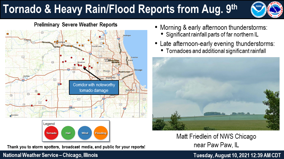
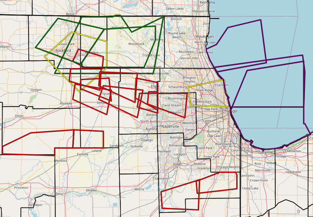
Two rounds of thunderstorms produced significant rainfall across portions of northern Illinois on Monday August 9th. A morning round of storms produced heavy rainfall across parts of northern Illinois, especially across portions of southern Boone and McHenry Counties where up to 3 to 4 inches of rain fell causing instances of urban and small stream flooding.
The afternoon and evening thunderstorms were mainly supercells that produced numerous tornadoes, some of which caused noteworthy tree and structural damage in portions of Ogle, DeKalb, and Kane Counties. NWS Chicago issued a total of 13 Tornado, 2 Severe Thunderstorm, and 3 Special Marine Warnings between 3:00 PM and 10:15 PM. A total of 10 tornadoes were confirmed in the NWS Chicago County Warning Area (CWA). |
 Preliminary Event Summary Graphic |
Tornadoes:
Full Public Information Statement
Tornado #1: North of Esmond EF-0
Summary: This brief tornado touched down near Lindenwood and Esmond Roads and produced minor damage to a farm outbuilding’s roof. The tornado was likely on the ground for less than one minute. |
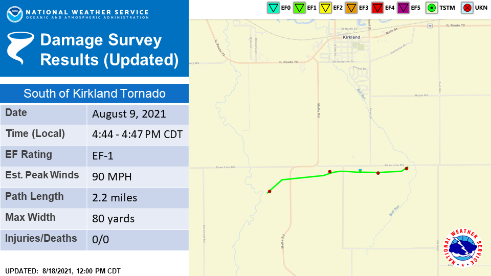
Tornado #2: South of Kirkland EF-1
Summary: After the tornado that occurred north of Esmond lifted, the same storm produced another brief tornado south of Kirkland. Based on ground video, this tornado may have intermittently skipped on the ground shortly after touching down west of Malta Road. Drone footage then shows crop damage increased in a farm east of Byers Road. The tornado then heavily damaged a barn on Base Line Rd. before it dissipated in the field east of Pearl Street. |
Tornado #3: McHenry EF-1
Summary: A brief tornado touched down at Petersen Farm on the north side of McHenry. The tornado tracked eastward and impacted a couple of townhouses along Evergreen Circle before lifting just before it reached the Home Depot store on Richmond Rd. The tornado was on the ground for less than a minute, damaged a barn and ground marker at Petersen Farm, and caused some damage to sidings and porches, in addition to removing a portion of a roof at the townhouse complex along Evergreen Circle. |
Tornado #4: Burlington EF-1
Summary: This tornado touched down just east of the DeKalb-Kane County line just west of Plank Road where it caused damage to a residence due west of Engel Road that was consistent with an EF-1 tornado, blowing a garage door in and uprooting several trees on the property. The tornado then tracked east along the south side of Plank Road, damaging a large farm outbuilding west of Lawrence Road. The tornado then curled southeast where it produced sporadic tree and crop damage along Waughon and Peplow Roads before lifting near the intersection of Burlington and Romke Roads |
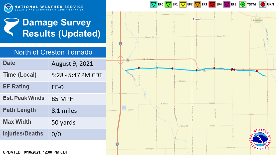
Tornado #5: North of Creston EF-0
Summary: This tornado developed immediately east of Interstate 39 near South Mulford Road and subsequently tracked eastward, paralleling Illinois Route 64. Damage to two farm outbuildings was noted, one on South Chamberlain Road and another on Edmond Road just east of the DeKalb County line. A video of the tornado shows that winds entered the building on the southwest facade which caused uplift of the roof and subsequent collapse of the walls. This damage, and damage to vegetation in the area was consistent with a high-end EF-0 tornado with winds of around 85 mph. The tornado continued to track east, immediately to the north of Route 64. Storm chaser video shows that the tornado crossed Route 64 immediately east of McQueen Road and continued east of Malta Road, where it produced some minor tree damage and dissipated soon afterwards. |
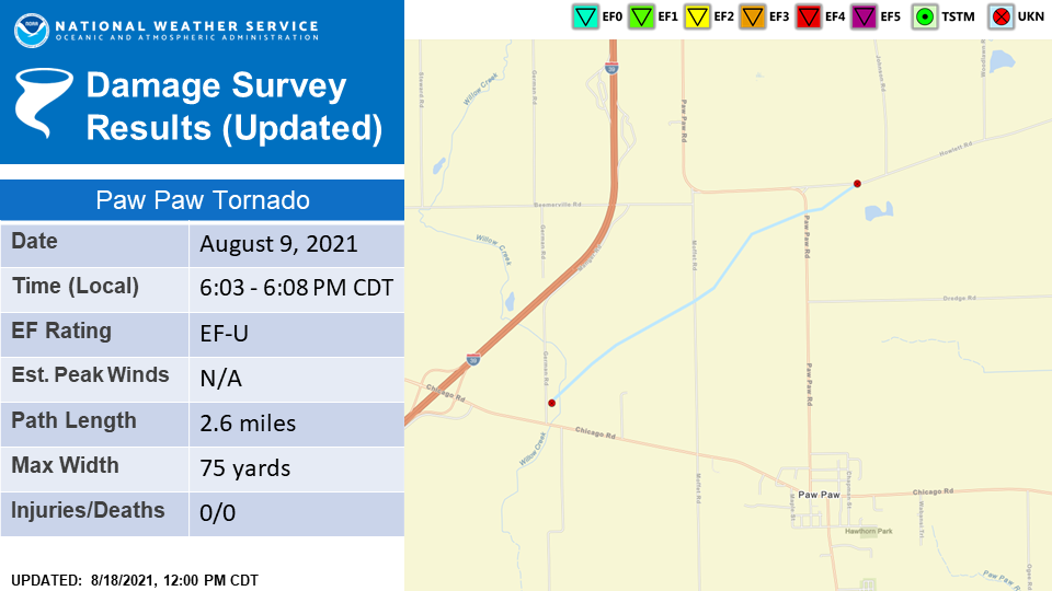
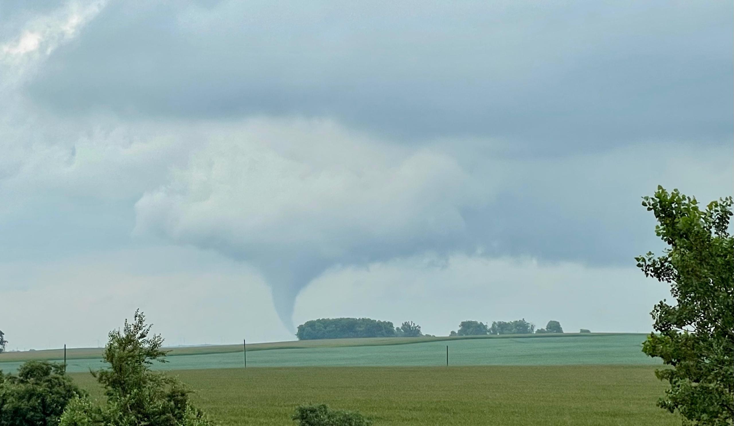
Tornado #6: Paw Paw EF-U
Summary: Crop damage seen on satellite imagery indicates that this tornado touched down west-northwest of Paw Paw near German Rd. just north of Chicago Rd. The tornado tracked to the northeast and produced a swath of damage in the corn fields that it crossed, with the most pronounced crop damage occurring between Moffet Rd. and Paw Paw Rd., based on drone footage and satellite imagery. The tornado then lifted just as it crossed Paw Paw Rd. and reached Howlett Rd. Since the tornado did not produce damage to any qualified damage indicators, a peak wind speed could not be estimated, and thus this tornado has been rated as an EF-U. |
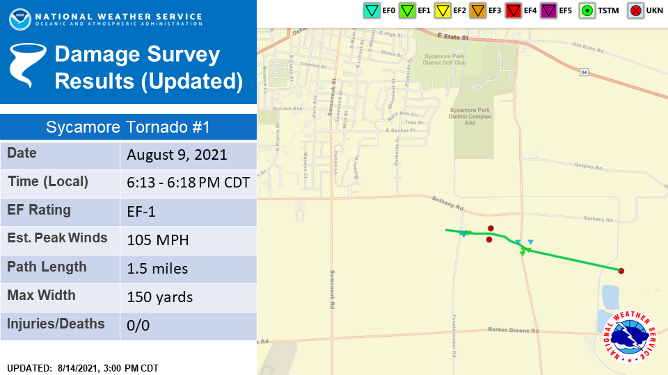
Tornado #7: Sycamore Tornado #1 EF-1
Summary: This tornado was associated with the same storm that spawned the tornado north of Creston and touched down west of Fenstermaker Road south of Bethany Road. There, it produced a concentrated corridor of damage where two farm outbuildings were nearly completely destroyed. Several trees in the area had trunks snapped near their bases, and a single family residence exhibited some shingle loss along with two broken windows. This damage is consistent with a high-end EF-1 tornado. Drone footage indicates that the tornado quickly widened to 150 yards as it snaked east towards Airport Road where it produced additional EF-1 damage to trees and farm outbuildings. Drone footage and ground video suggest the tornado lifted near the South Branch of the Kishwaukee River to the north of Barber Greene Road. |
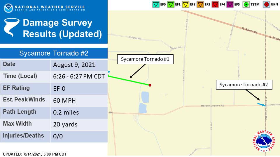
Tornado #8: Sycamore Tornado #2 EF-0
Summary: Based on an NWS ground survey and spotter video, a second brief touchdown occurred on Barber Greene Road near the DeKalb and Kane County lines where some tree damage was noted. |
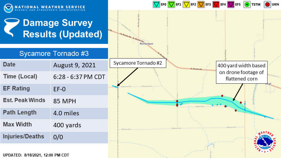
Tornado #9: Sycamore Tornado #3 EF-0
Summary: Based on spotter video, a third tornado associated with a new mesocyclone touched down south of Peterson Road and tracked east where it caused damage to several properties between Fabris and Meredith Roads. Drone footage then suggests the tornado widened considerably, to nearly 400 yards, as it tracked southeast across a field north of Welter Road and west of Meredith Road. The tornado then contracted, crossed Welter Road, and dissipated. |
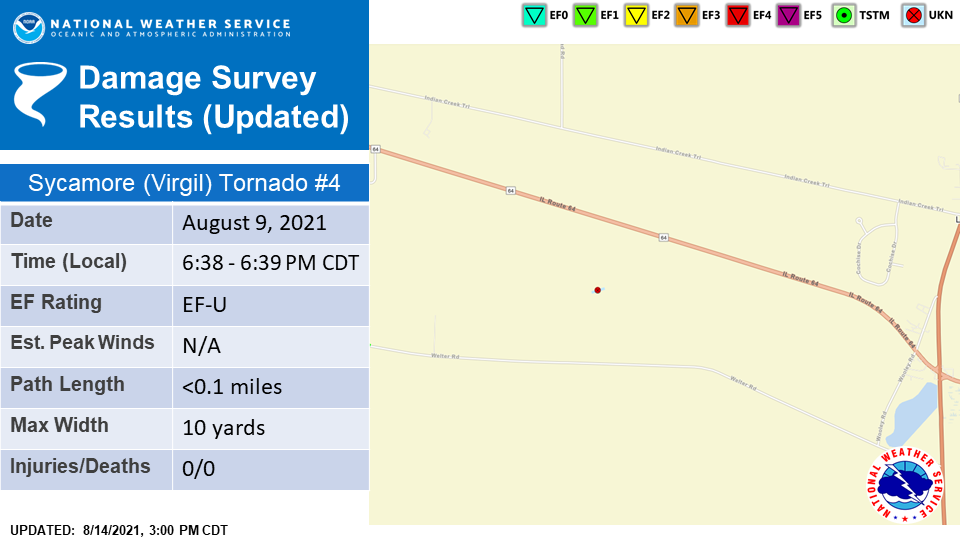
Tornado #10: Sycamore (Virgil) Tornado #4 EF-U
Summary: Spotter video shows a brief touchdown in a field to the south of Route 64 and north of Welter Road. Location was estimated by time matching spotter video, landmarks, and radar data. Since the tornado did not produce damage to any qualified damage indicators, a peak wind speed could not be estimated, and thus this tornado has been rated as an EF-U. |
The Enhanced Fujita (EF) Scale classifies tornadoes into the following categories:
| EF0 Weak 65-85 mph |
EF1 Moderate 86-110 mph |
EF2 Significant 111-135 mph |
EF3 Severe 136-165 mph |
EF4 Extreme 166-200 mph |
EF5 Catastrophic 200+ mph |
 |
|||||
When a tornado is known to have occurred but does not cause damage to any qualified damage indicators, or if the only damage is located in an area that is inaccessible to NWS storm survey personnel, then a tornado may be assigned the EF-Unknown (EF-U) rating.
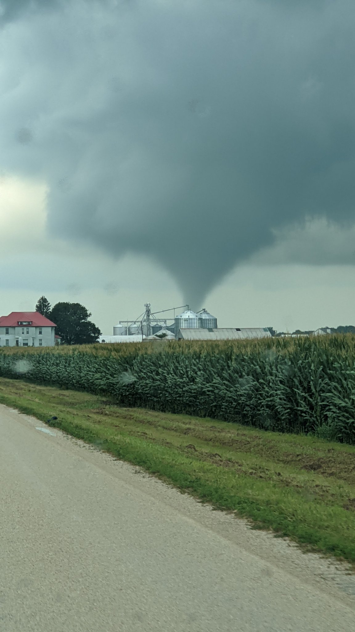
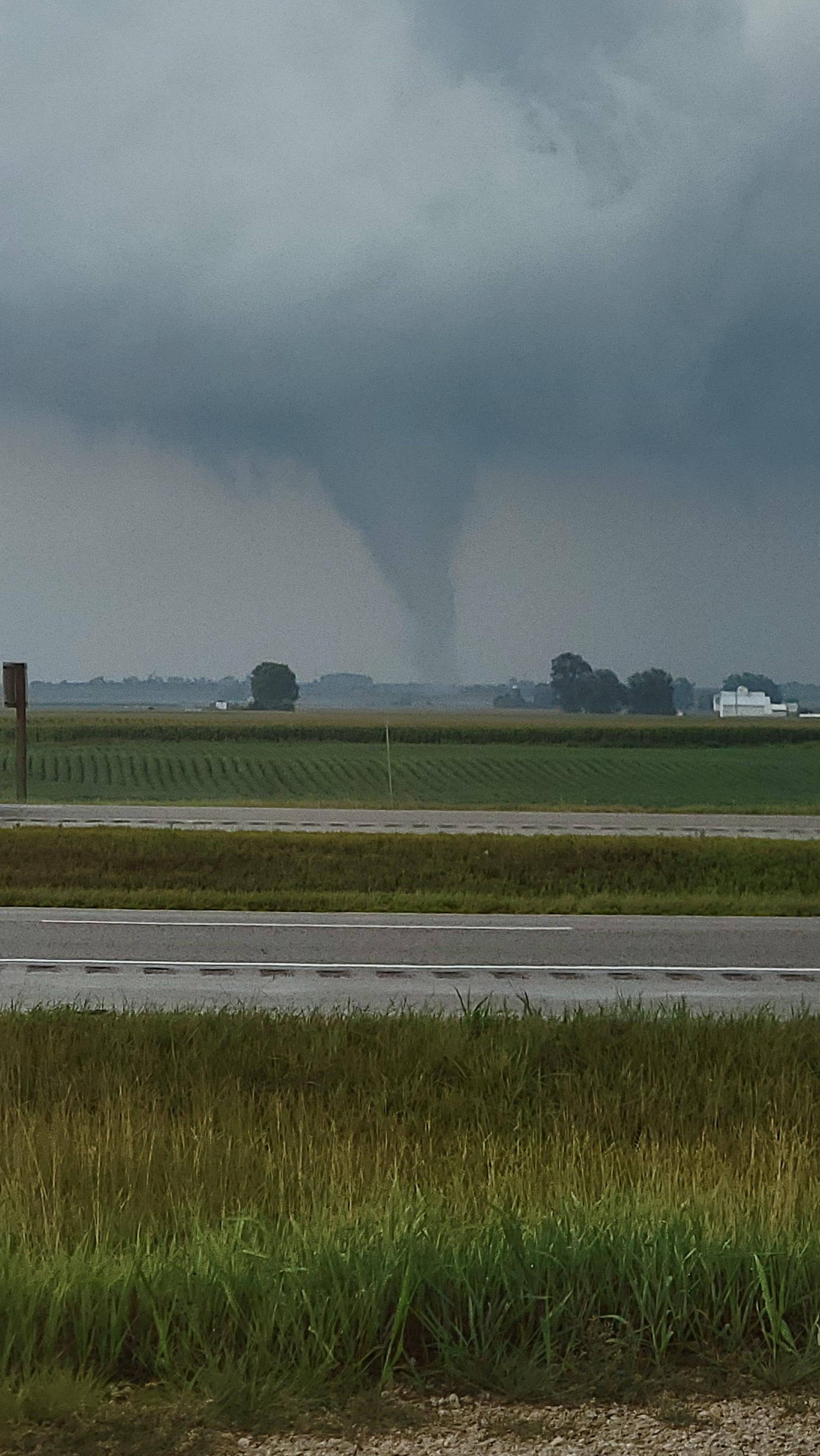
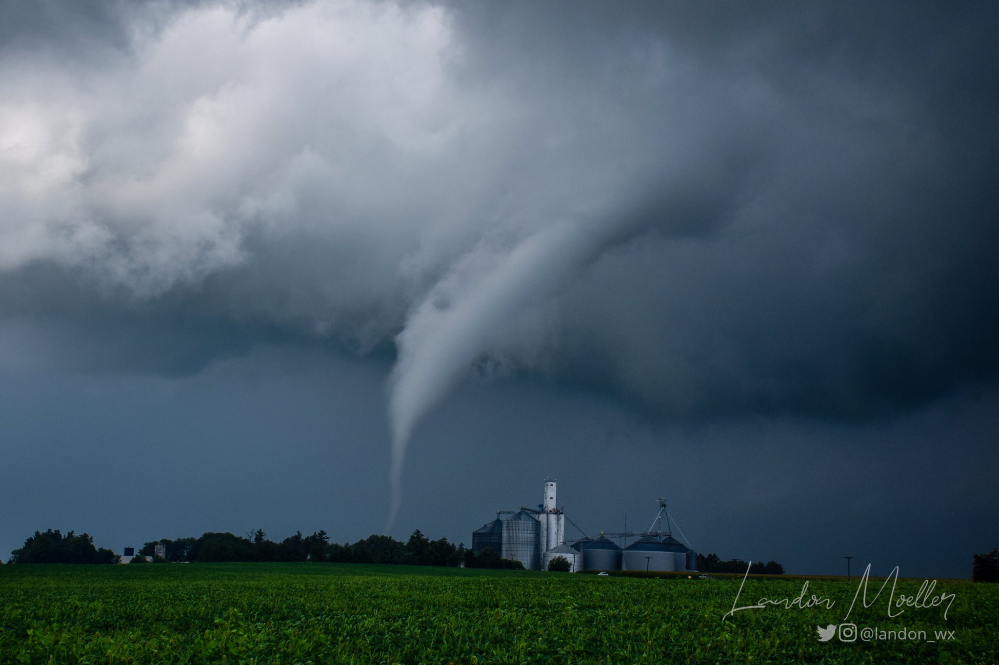
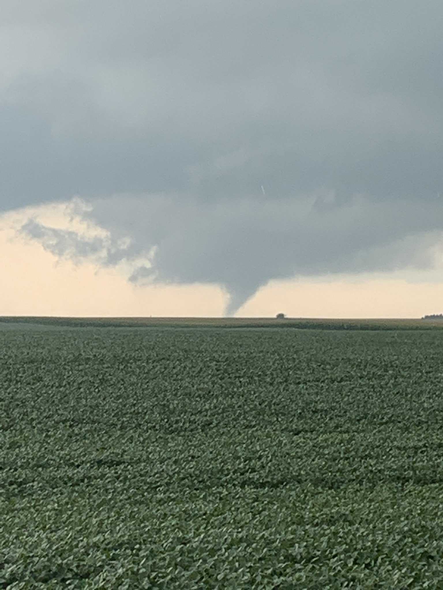
Photos:
 |
 |
 |
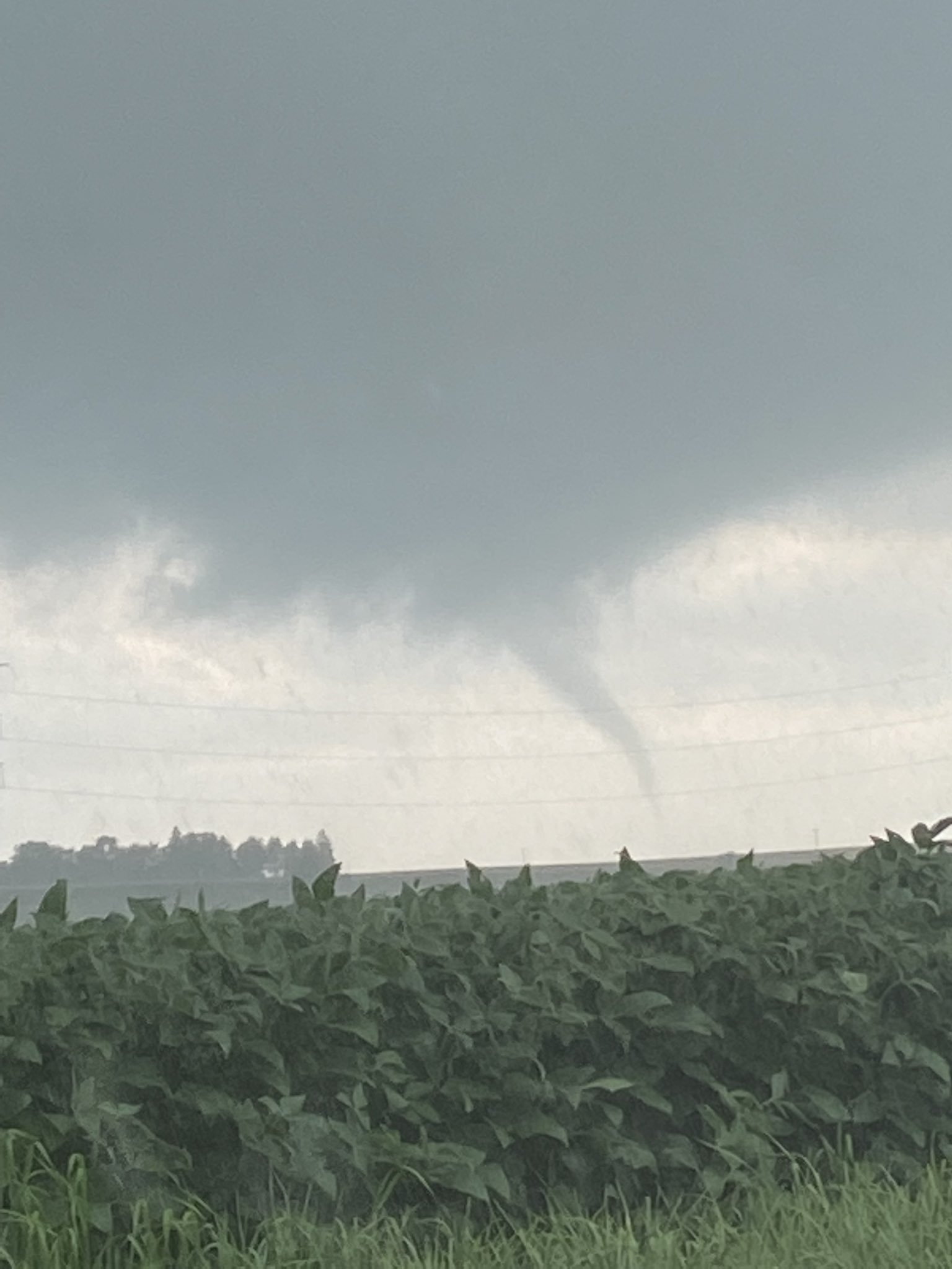 |
| Tornado north of Paw Paw. Courtesy of Matt Friedlein. | Tornado northwest of Malta. Courtesy of Bob Waszak. | Tornado near the Kane and DeKalb County line northwest of Maple Park. Courtesy of Galen Cooper. | Tornado near Kirkland. Courtesy of Tyler Pardun. |
 |
 |
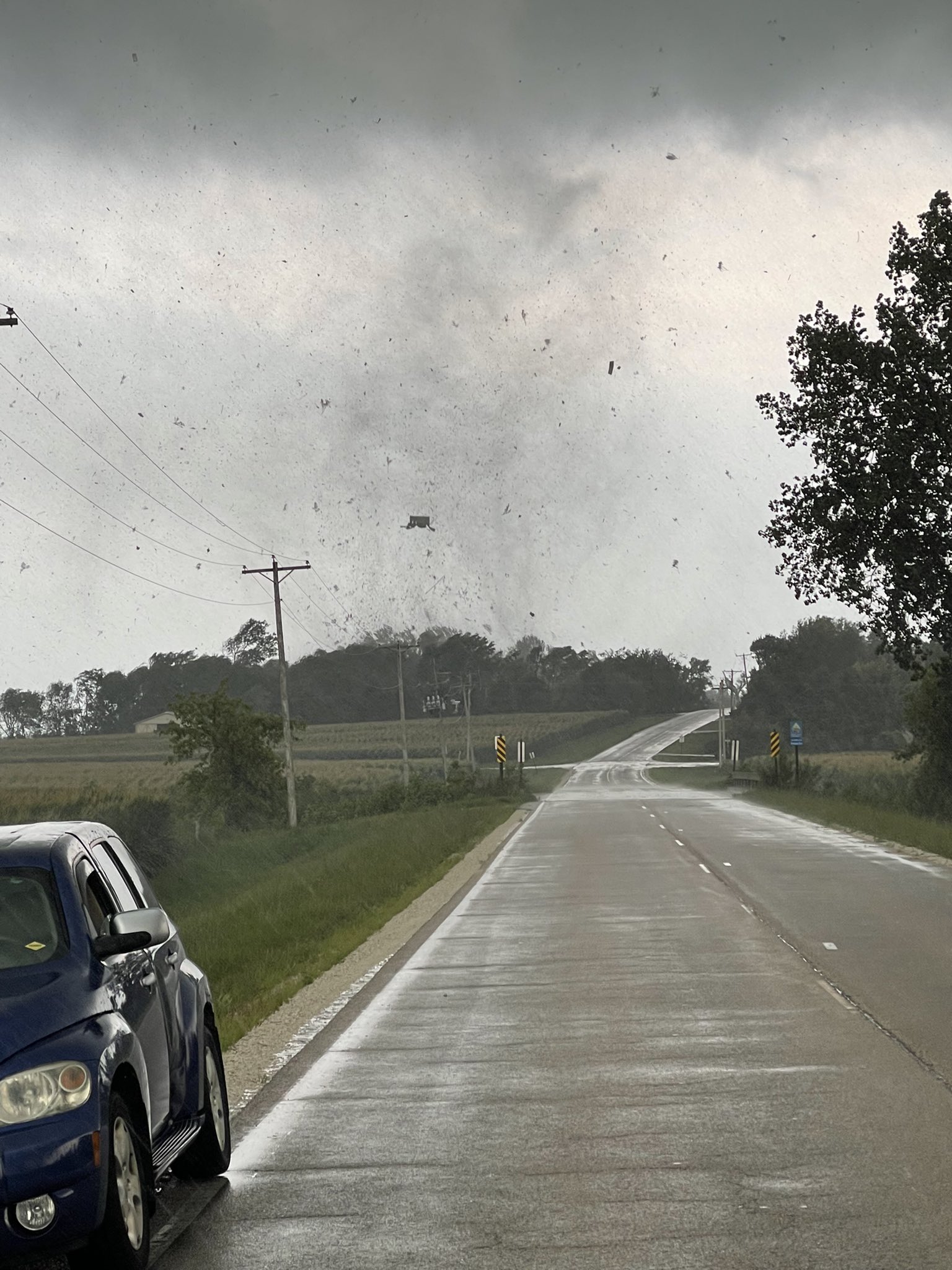 |
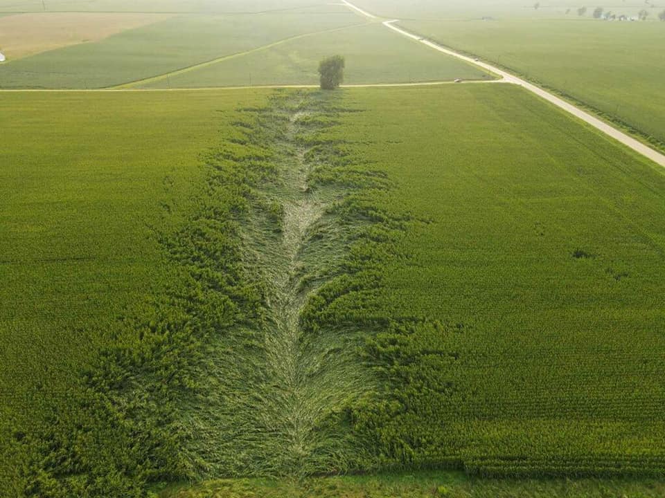 |
| Tornado north of Esmond. Courtesy of Landon Moeller. | Tornado northwest of Malta. Courtesy of Kaylan Patel. | Tornado near Sycamore. Courtesy of Diego Garcia. | Swirl pattern in corn caused by the Kirkland Tornado. Couresty of Jake Miller. |
Radar and Warnings Issued:
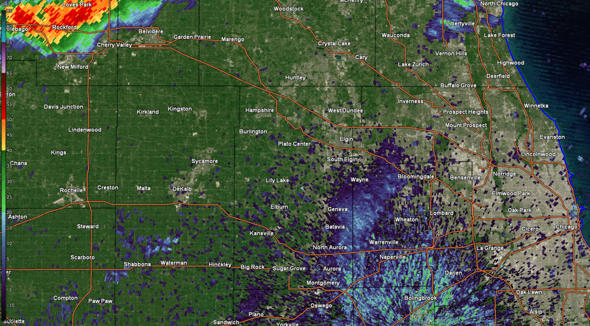 |
 |
| KLOT Radar loop from 3 pm - 7:45 pm with warnings overlaid. | Tornado Warnings (red), Severe Thunderstorm Warnings (yellow), Special Marine Warnings (purple), and Flood Advisories (green) issued on Monday afternoon and evening. |
Storm Reports
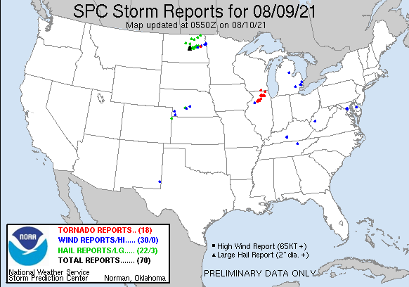 |
| August 9th Storm Reports |
PRELIMINARY LOCAL STORM REPORT...SUMMARY
NATIONAL WEATHER SERVICE CHICAGO IL
1131 PM CDT MON AUG 9 2021

..TIME...   ...EVENT...      ...CITY LOCATION...     ...LAT.LON...
..DATE...   ....MAG....      ..COUNTY LOCATION..ST.. ...SOURCE....
            ..REMARKS..

0948 PM     HEAVY RAIN       1 WNW SOUTH ELGIN       42.00N 88.31W
08/09/2021  M2.65 INCH       KANE               IL   PUBLIC

            RAINFALL TOTAL FOR THE DAY.

0658 PM     TORNADO          1 WSW CAMPTON HILLS     41.93N 88.42W
08/09/2021                   KANE               IL   TRAINED SPOTTER

            MULTIPLE REPORTS OF A BRIEF TORNADO NEAR
            CAMPTON HILLS.

0644 PM     TORNADO          1 ESE LILY LAKE         41.95N 88.46W
08/09/2021                   KANE               IL   AMATEUR RADIO

            MULTIPLE REPORTS OF A WEAK TORNADO NEAR LILY
            LAKE.

0631 PM     TORNADO          1 S VIRGIL              41.93N 88.54W
08/09/2021                   KANE               IL   AMATEUR RADIO

            RAIN-WRAPPED TORNADO REPORTED NEAR BEITH
            ROAD AND MEREDITH ROAD.

0629 PM     FUNNEL CLOUD     3 NE MAPLE PARK         41.94N 88.56W
08/09/2021                   KANE               IL   AMATEUR RADIO

            TORNADO ON THE GROUND NORTHEAST OF MAPLE
            PARK.

0621 PM     HEAVY RAIN       ISLAND LAKE             42.27N 88.20W
08/09/2021  M2.78 INCH       LAKE               IL   TRAINED SPOTTER

            RAINFALL AT PERSONAL WEATHER STATION SINCE 7
            AM.

0618 PM     TORNADO          4 ESE SYCAMORE          41.96N 88.62W
08/09/2021                   DE KALB            IL   TRAINED SPOTTER

            TORNADO ON THE GROUND EAST OF SYCAMORE.
            POSSIBLE DAMAGE TO STRUCTURES.

0617 PM     TORNADO          2 SE SYCAMORE           41.96N 88.66W
08/09/2021                   DE KALB            IL   TRAINED SPOTTER

            TORNADO ON THE GROUND EAST OF SPOTTER AT
            BETHANY ROAD AND IL-23.

0613 PM     TORNADO          2 SSE SYCAMORE          41.97N 88.67W
08/09/2021                   DE KALB            IL   BROADCAST MEDIA

            TV CREW REPORTS DAMAGE TO TREES AND POWER
            LINES NEAR BETHANY ROAD AND FENSTERMAKER
            ROAD NEAR SYCAMORE. TIME ESTIMATED BY RADAR.

0605 PM     FUNNEL CLOUD     3 WSW SYCAMORE          41.97N 88.74W
08/09/2021                   DE KALB            IL   TRAINED SPOTTER

            MULTIPLE REPORTS RECEIVED OF WALL CLOUD WITH
            POSSIBLE FUNNELS BETWEEN DEKALB AND
            SYCAMORE.

0602 PM     TORNADO          1 NW PAW PAW            41.70N 89.00W
08/09/2021                   LEE                IL   NWS EMPLOYEE

            MULTIPLE REPORTS OF BRIEF TORNADO TOUCHDOWN.

0528 PM     TORNADO          2 SW ESMOND             42.01N 88.96W
08/09/2021                   OGLE               IL   TRAINED SPOTTER

            UPDATES PREVIOUS TORNADO REPORT FROM 2 SW
            ESMOND. NUMEROUS REPORTS OF SMALL TORNADO
            WITH VISIBLE DEBRIS ON THE GROUND. VIDEO
            SHARED TO SOCIAL MEDIA SHOWS SMALL TORNADO
            ON THE GROUND MOVING EAST ALONG IL-64 FOR
            SEVERAL MINUTES.

0526 PM     TORNADO          2 WSW BURLINGTON        42.05N 88.58W
08/09/2021                   KANE               IL   LAW ENFORCEMENT

            CORRECTS AND UPDATES PREVIOUS TSTM WND DMG
            REPORT FROM 2 WSW BURLINGTON. KANE COUNTY
            SHERIFFS OFFICE REPORTS DAMAGE TO A
            STRUCTURE ALONG PLANK ROAD NEAR EAGLE ROAD.
            CONFIRMED TORNADO WITH THIS DAMAGE GIVEN
            TORNADO DEBRIS SIGNATURE ON KLOT FROM ABOUT
            5:24 PM UNTIL 5:33 PM. TIME ESTIMATED BY
            RADAR.

0452 PM     TORNADO          3 SW KINGSTON           42.07N 88.80W
08/09/2021                   DE KALB            IL   PUBLIC

            MULTIPLE REPORTS OF A TORNADO SOUTH OF
            KENTLAND AND KINGSTON.

0448 PM     TORNADO          1 N MCHENRY             42.36N 88.27W
08/09/2021                   MCHENRY            IL   LAW ENFORCEMENT

            MCHENRY PD REPORTS POSSIBLE TORNADO NEAR
            BLAKE ROAD AND RICHMOND ROAD IN MCHENRY.

0440 PM     TSTM WND DMG     1 ESE MCCULLOM LAKE     42.36N 88.27W
08/09/2021                   MCHENRY            IL   LAW ENFORCEMENT

            DAMAGE TO PORCHES ALONG EVERGREEN CIRCLE IN
            MCHENRY. TIME ESTIMATED BY RADAR.

0432 PM     TORNADO          2 SE ESMOND             42.02N 88.91W
08/09/2021                   DE KALB            IL   PUBLIC

            MULTIPLE REPORTS OF A TORNADO SOUTHEAST OF
            ESMOND.

0430 PM     FUNNEL CLOUD     MONROE CENTER           42.10N 89.00W
08/09/2021                   OGLE               IL   BROADCAST MEDIA

            TV CREW SPOTTED FUNNEL CLOUD FOR 5-10
            SECONDS NEAR MONROE CENTER.

0410 PM     FLOOD            3 SE BELVIDERE          42.23N 88.80W
08/09/2021                   BOONE              IL   TRAINED SPOTTER

            FLOODING OF SMALL STREAMS AND DITCHES.
            RELAYED VIA SPOTTER NETWORK.

0405 PM     FLOOD            1 E ROCKFORD            42.27N 89.07W
08/09/2021                   WINNEBAGO          IL   PUBLIC

            MULTIPLE VIDEOS SHARED VIA SOCIAL MEDIA SHOW
            MINOR STREET FLOODING IN ROCKFORD.

0355 PM     FLOOD            1 NNW ROCKFORD          42.29N 89.11W
08/09/2021                   WINNEBAGO          IL   BROADCAST MEDIA

            PHOTO SHARED VIA SOCIAL MEDIA BY BROADCAST
            MEDIA SHOWS MINOR FLOODING OF AUBURN STREET
            NEAR RUSSELL AVENUE. TWO LANES BLOCKED, ROAD
            CLOSED BY POLICE.

0330 PM     HEAVY RAIN       1 NE ROCKFORD           42.29N 89.07W
08/09/2021  M2.52 INCH       WINNEBAGO          IL   PUBLIC

            UPDATES PREVIOUS HEAVY RAIN REPORT FROM 1 NE
            ROCKFORD. PRIVATE WEATHER STATION REPORTS
            2.52 INCHES OVER 30 MINUTES AND 1.82 INCHES
            OVER 20 MINUTES JUST NORTH OF DOWNTOWN
            ROCKFORD. STORM TOTAL SINCE 2:00 PM IS 2.53
            INCHES.

0305 PM     FLOOD            1 S LOVES PARK          42.30N 89.06W
08/09/2021                   WINNEBAGO          IL   PUBLIC

            NUMEROUS PUBLIC REPORTS OF STREET FLOODING
            RECEIVED VIA MPING IN ROCKFORD AND LOVES
            PARK AREAS.

1200 PM     HEAVY RAIN       2 SSE WOODSTOCK         42.28N 88.43W
08/09/2021  M4.40 INCH       MCHENRY            IL   PUBLIC

            PRIVATE WEATHER STATION REPORTED 4.4 INCHES
            SINCE 6:00 AM, WITH ABOUT 2 INCHES IN 1 HOUR
            ENDING AT 10:25 AM.

1200 PM     HEAVY RAIN       2 WSW MARENGO           42.24N 88.65W
08/09/2021  M4.54 INCH       MCHENRY            IL   PUBLIC

            PRIVATE WEATHER STATION REPORTED 4.54 INCHES
            SINCE 6:00 AM, WITH OVER 2.8 INCHES IN 90
            MINUTES.

1200 PM     HEAVY RAIN       1 WSW WOODSTOCK         42.31N 88.48W
08/09/2021  M4.21 INCH       MCHENRY            IL   PUBLIC

            PRIVATE WEATHER STATION REPORTED 4.21 INCHES
            SINCE 6:00 AM, WITH OVER 1.9 INCHES IN 1
            HOUR ENDING 10:15 AM.

1200 PM     HEAVY RAIN       2 SE MARENGO            42.24N 88.59W
08/09/2021  E4.55 INCH       MCHENRY            IL   PUBLIC

            PRIVATE WEATHER STATION REPORTS 4.55 INCHES
            SINCE 6:00 AM, WITH OVER 2 INCHES IN 1 HOUR
            ENDING AT 10:00 AM.

1200 PM     HEAVY RAIN       3 SW TIMBERLANE         42.30N 88.90W
08/09/2021  M4.68 INCH       BOONE              IL   PUBLIC

            PRIVATE WEATHER STATION REPORTED 4.68 INCHES
            SINCE 6:00 AM, WITH OVER 2.5 INCHES IN 1
            HOUR ENDING AT 9:30 AM.

1145 AM     HEAVY RAIN       2 NE GARDEN PRAIRIE     42.28N 88.69W
08/09/2021  M4.46 INCH       MCHENRY            IL   PUBLIC

            PRIVATE WEATHER STATION REPORTED 4.46 INCHES
            SINCE 6:00 AM, WITH OVER 2.2 INCHES IN 1
            HOUR ENDING 9:55 AM.

0930 AM     HEAVY RAIN       1 WNW CHERRY VALLEY     42.24N 88.98W
08/09/2021  M2.19 INCH       WINNEBAGO          IL   TRAINED SPOTTER

            2.19 INCHES AS OF 9:30 AM, WITH 1.92 INCHES
            IN 1 HOUR.
Rain Reports
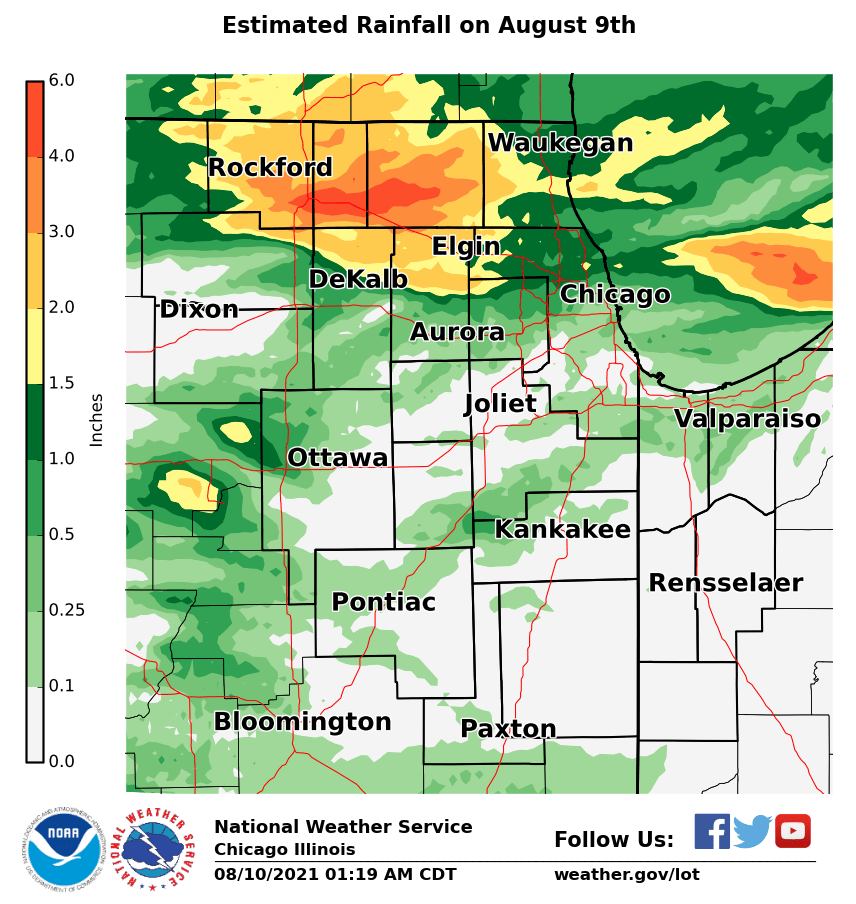 |
| August 9th Rainfall |
COCORAHS PRECIPITATION SUMMARY
NATIONAL WEATHER SERVICE CHICAGO IL
1000 AM CDT TUE AUG 10 2021

COCORAHS PRECIPITATION REPORTS
THESE REPORTS ARE CONSIDERED SUPPLEMENTAL AND UNOFFICIAL
VALUES ARE FOR THE PREVIOUS 24 HOURS ENDING AROUND 7 AM LOCAL TIME


:COCORAHS PRECIPITATION REPORTS IN ILLINOIS

:                                               SNOW   SNOW  WATER
:                                        PCPN   FALL  DEPTH  EQUIV

IL-MCH-33 : WOODSTOCK 3.8 SW         *   : 5.11 /  MM /   MM /   MM
IL-MCH-87 : MARENGO 0.7 NNW          *   : 4.71 /  MM /   MM /   MM
IL-MCH-52 : WOODSTOCK 0.8 SSW        *   : 3.96 /  MM /   MM /   MM
IL-WN-48  : ROCKFORD 3.8 NNW         *   : 3.89 /  MM /   MM /   MM
IL-MCH-13 : BULL VALLEY 2.5 WNW      *   : 3.67 / 0.0 /  0.0 / 0.00
IL-MCH-77 : WONDER LAKE 1.4 NE       *   : 3.32 /  MM /   MM /   MM
IL-WN-43  : ROCKFORD 3.8 S           *   : 3.05 /  MM /   MM /   MM
IL-DK-27  : KINGSTON 2.3 WNW         *   : 3.00 /  MM /   MM /   MM
IL-KN-86  : ELGIN 7.5 WSW            *   : 2.98 /  MM /   MM /   MM
IL-MCH-96 : HUNTLEY 1.6 SW           *   : 2.84 /  MM /   MM /   MM
IL-WN-44  : WINNEBAGO 5.4 SE         *   : 2.79 /  MM /   MM /   MM
IL-MCH-80 : HUNTLEY 0.1 SSE          *   : 2.64 / 0.0 /  0.0 /   MM
IL-MCH-83 : CRYSTAL LAKE 1.0 WSW     *   : 2.56 /  MM /   MM /   MM
IL-WN-41  : SOUTH BELOIT 1.5 ESE     *   : 2.54 /  MM /   MM /   MM
IL-WN-51  : MACHESNEY PARK 1.5 SSW   *   : 2.42 /  MM /   MM /   MM
IL-BN-14  : CAPRON 0.1 N             *   : 2.37 /  MM /   MM /   MM
IL-MCH-94 : MCHENRY 2.4 E            *   : 2.36 /  MM /   MM /   MM
IL-WN-26  : ROCKFORD 1.5 ENE         *   : 2.36 /  MM /   MM /   MM
IL-MCH-43 : ALGONQUIN 0.7 N          *   : 2.35 / 0.0 /  0.0 / 0.00
IL-WN-45  : MACHESNEY PARK 0.9 W     *   : 2.33 /  MM /   MM /   MM
IL-MCH-102: ALGONQUIN 3.4 W          *   : 2.25 /  MM /   MM /   MM
IL-LK-100 : LONG LAKE 0.4 S          *   : 2.23 /  MM /   MM /   MM
IL-KN-67  : ST. CHARLES 6.0 NW       *   : 2.14 / 0.0 /  0.0 /   MM
IL-MCH-34 : PISTAKEE HIGHLANDS 0.4 SW*   : 2.12 /  MM /   MM /   MM
IL-KN-98  : GILBERTS 0.5 N           *   : 2.10 /  MM /   MM /   MM
IL-BN-19  : BELVIDERE 5.0 NNW        *   : 2.10 /  MM /   MM /   MM
IL-LK-114 : ROUND LAKE HEIGHTS 0.5 NE*   : 2.02 /  MM /   MM /   MM
IL-MCH-103: HARVARD 4.4 NNE          *   : 2.01 /  MM /   MM /   MM
IL-KN-95  : ELGIN 2.5 W              *   : 1.94 / 0.0 /   MM /   MM
IL-CK-317 : HOFFMAN ESTATES 0.6 ESE  *   : 1.93 /  MM /   MM /   MM
IL-LK-81  : LAKE VILLA 2.3 WSW       *   : 1.93 /  MM /   MM /   MM
IL-WN-40  : ROCKFORD 4.5 WSW         *   : 1.92 /  MM /   MM /   MM
IL-MCH-95 : CARY 0.5 SSW             *   : 1.92 /  MM /   MM /   MM
IL-MCH-35 : LAKEMOOR 1.9 NW          *   : 1.84 /  MM /   MM /   MM
IL-CK-150 : ARLINGTON HEIGHTS 1.2 S  *   : 1.77 /  MM /   MM /   MM
IL-DP-124 : BARTLETT 1.4 SE          *   : 1.77 /  MM /   MM /   MM
IL-LK-9   : LAKE VILLA 1.1 SSW       *   : 1.77 /  MM /   MM /   MM
IL-DP-100 : BARTLETT 1.1 SE          *   : 1.76 /  MM /   MM /   MM
IL-LK-121 : LIBERTYVILLE 0.4 ESE     *   : 1.75 /  MM /   MM /   MM
IL-WN-50  : ROCKTON 3.1 SW           *   : 1.69 / 0.0 /  0.0 /   MM
IL-LK-54  : MUNDELEIN 0.5 NNE        *   : 1.67 /  MM /   MM /   MM
IL-CK-75  : ELK GROVE VILLAGE 2.2 WSW*   : 1.60 /  MM /   MM /   MM
IL-LK-112 : LINDENHURST 1.0 ENE      *   : 1.60 /  MM /   MM /   MM
IL-CK-106 : HOFFMAN ESTATES 4.6 W    *   : 1.59 /  MM /   MM /   MM
IL-KN-9   : ELGIN 1.0 S              *   : 1.59 / 0.0 /  0.0 /   MM
IL-LK-42  : GURNEE 1.6 W             *   : 1.58 /  MM /   MM /   MM
IL-LK-27  : WINTHROP HARBOR 0.7 SSW  *   : 1.58 /  MM /   MM /   MM
IL-BN-20  : CALEDONIA 1.4 W          *   : 1.57 /  MM /   MM /   MM
IL-LK-87  : LAKE ZURICH 1.3 N        *   : 1.57 /  MM /   MM /   MM
IL-KN-118 : SLEEPY HOLLOW 0.7 W      *   : 1.56 /  MM /   MM /   MM
IL-LK-78  : LIBERTYVILLE 1.8 ESE     *   : 1.55 /  MM /   MM /   MM
IL-CK-278 : HOFFMAN ESTATES 1.6 SE   *   : 1.51 /  MM /   MM /   MM
IL-CK-346 : PALATINE 1.2 NW          *   : 1.50 /  MM /   MM /   MM
IL-CK-294 : PALATINE 1.4 NNE         *   : 1.49 /  MM /   MM /   MM
IL-CK-192 : PARK RIDGE 0.7 WNW       *   : 1.42 /  MM /   MM /   MM
IL-CK-334 : EVANSTON 0.6 S           *   : 1.39 /  MM /   MM /   MM
IL-CK-180 : PARK RIDGE 0.5 SSW       *   : 1.38 /  MM /   MM /   MM
IL-CK-336 : EVANSTON 0.8 ESE         *   : 1.36 / 0.0 /  0.0 / 0.00
IL-LK-19  : WAUKEGAN 2.2 N           *   : 1.36 /  MM /   MM /   MM
IL-LK-16  : BUFFALO GROVE 1.5 N      *   : 1.32 /  MM /   MM /   MM
IL-CK-367 : MOUNT PROSPECT 0.2 NNE   *   : 1.32 /  MM /   MM /   MM
IL-CK-63  : ELK GROVE VILLAGE 0.6 ESE*   : 1.29 /  MM /   MM /   MM
IL-CK-321 : EVANSTON 0.9 S           *   : 1.27 /  MM /   MM /   MM
IL-CK-121 : PALATINE 1.3 E           *   : 1.26 / 0.0 /  0.0 /   MM
IL-DP-155 : MEDINAH 1.0 SSW          *   : 1.25 / 0.0 /  0.0 / 0.00
IL-CK-331 : NORTHFIELD 0.3 S         *   : 1.19 /  MM /   MM /   MM
IL-CK-193 : WINNETKA 0.8 ESE         *   : 1.18 /  MM /   MM /   MM
IL-LK-103 : BUFFALO GROVE 1.3 ESE    *   : 1.14 /  MM /   MM /   MM
IL-LK-23  : WINTHROP HARBOR 0.2 SSE  *   : 1.12 /  MM /   MM /   MM
IL-CK-326 : MORTON GROVE 1.2 WNW     *   : 1.05 /  MM /   MM /   MM
IL-CK-131 : SCHAUMBURG 2.0 E         *   : 1.05 /  MM /   MM /   MM
IL-CK-325 : MOUNT PROSPECT 1.3 SSE   *   : 0.99 /  MM /   MM /   MM
IL-LK-118 : HIGHLAND PARK 2.1 WNW    *   : 0.97 /  MM /   MM /   MM
IL-LK-39  : RIVERWOODS 0.4 ENE       *   : 0.91 /  MM /   MM /   MM
IL-CK-53  : GLENCOE 0.1 NW           *   : 0.88 /  MM /   MM /   MM
IL-CK-285 : HARWOOD HEIGHTS 0.4 NNE  *   : 0.84 /  MM /   MM /   MM
IL-LK-15  : BANNOCKBURN 0.5 ESE      *   : 0.81 /  MM /   MM /   MM
IL-CK-94  : LINCOLNWOOD 1.8 E        *   : 0.78 /  MM /   MM /   MM
IL-KN-130 : ST. CHARLES 0.2 NNW      *   : 0.77 /  MM /   MM /   MM
IL-KD-119 : YORKVILLE 2.3 NNE        *   : 0.70 /  MM /   MM /   MM
IL-DP-117 : ELMHURST 2.0 SE          *   : 0.64 /  MM /   MM /   MM
IL-CK-214 : ROGERS PARK 1.5 SW       *   : 0.64 /  MM /   MM /   MM
IL-DP-42  : CAROL STREAM 0.3 SSE     *   : 0.64 /  MM /   MM /   MM
IL-DP-40  : LOMBARD 1.0 NNW          *   : 0.63 /  MM /   MM /   MM
IL-DP-150 : BLOOMINGDALE 1.2 ESE     *   : 0.63 /  MM /   MM /   MM
IL-CK-345 : FRANKLIN PARK 0.5 SSE    *   : 0.58 /  MM /   MM /   MM
IL-KN-96  : ELBURN 0.3 NW            *   : 0.58 /  MM /   MM /   MM
IL-DP-173 : LOMBARD 1.2 N            *   : 0.56 /  MM /   MM /   MM
IL-KN-121 : GENEVA 1.3 NW            *   : 0.56 / 0.0 /  0.0 / 0.00
IL-DP-132 : WHEATON 2.0 NNE          *   : 0.53 / 0.0 /  0.0 / 0.00
IL-KN-134 : MAPLE PARK 3.9 S         *   : 0.52 /  MM /   MM /   MM
IL-DP-163 : LOMBARD 1.2 E            *   : 0.52 /  MM /   MM /   MM
IL-DK-36  : DE KALB 3.5 WSW          *   : 0.47 /  MM /   MM /   MM
IL-WL-73  : WILMINGTON 2.6 SE        *   : 0.44 /  MM /   MM /   MM
IL-KN-119 : MAPLE PARK 3.1 SE        *   : 0.43 /  MM /   MM /   MM
IL-LS-49  : NORTH UTICA 6.3 N        *   : 0.38 /  MM /   MM /   MM
IL-KN-133 : GENEVA 0.9 E             *   : 0.37 /  MM /   MM /   MM
IL-KD-106 : YORKVILLE 2.8 NE         *   : 0.37 /  MM /   MM /   MM
IL-LS-57  : MENDOTA 0.4 ENE          *   : 0.35 /  MM /   MM /   MM
IL-DP-38  : ELMHURST 0.4 SW          *   : 0.33 /  MM /   MM /   MM
IL-CK-74  : OAK PARK 1.3 NNE         *   : 0.32 / 0.0 /   MM /   MM
IL-DP-27  : NAPERVILLE 2.1 ESE       *   : 0.32 /  MM /   MM /   MM
IL-KN-78  : GENEVA 1.3 SSW           *   : 0.32 / 0.0 /  0.0 / 0.00
IL-CK-361 : GLENVIEW 0.7 SE          *   : 0.31 /  MM /   MM /   MM
IL-DP-172 : WEST CHICAGO 3.0 SSE     *   : 0.31 /  MM /   MM /   MM
IL-CK-61  : OAK PARK 1.0 SW          *   : 0.30 /  MM /   MM /   MM
IL-KN-128 : BATAVIA 3.4 WSW          *   : 0.30 /  MM /   MM /   MM
IL-CK-323 : CHICAGO 6.8 NW           *   : 0.29 /  MM /   MM /   MM
IL-DP-176 : WINFIELD 0.6 SSW         *   : 0.29 /  MM /   MM /   MM
IL-KN-127 : GENEVA 0.6 SSE           *   : 0.28 /  MM /   MM /   MM
IL-KN-104 : GENEVA 3.9 WSW           *   : 0.28 / 0.0 /  0.0 / 0.00
IL-DP-30  : LISLE 0.5 WSW            *   : 0.27 /  MM /   MM /   MM
IL-DP-175 : NAPERVILLE 0.9 ENE       *   : 0.27 /  MM /   MM /   MM
IL-KN-22  : GENEVA 1.0 SSW           *   : 0.27 /  MM /   MM /   MM
IL-WL-42  : MOKENA 1.3 W             *   : 0.26 /  MM /   MM /   MM
IL-WL-164 : WILMINGTON 0.9 ENE       *   : 0.26 /  MM /   MM /   MM
IL-DP-101 : AURORA 3.8 SE            *   : 0.26 / 0.0 /  0.0 / 0.00
IL-KN-23  : BATAVIA 1.5 WNW          *   : 0.25 /  MM /   MM /   MM
IL-KD-5   : MONTGOMERY 0.8 SSE       *   : 0.24 /  MM /   MM /   MM
IL-KD-109 : YORKVILLE 1.0 N          *   : 0.24 /  MM /   MM /   MM
IL-WL-79  : PEOTONE 0.5 SE           *   : 0.24 /  MM /   MM /   MM
IL-WL-97  : NEW LENOX 3.3 E          *   : 0.23 / 0.0 /  0.0 / 0.00
IL-DP-16  : AURORA 3.6 SE            *   : 0.23 /  MM /   MM /   MM
IL-KN-33  : NORTH AURORA 1.5 NE      *   : 0.23 /  MM /   MM /   MM
IL-CK-366 : OAK PARK 1.0 NNE         *   : 0.23 /  MM /   MM /   MM
IL-DP-164 : WEST CHICAGO 3.5 SE      *   : 0.22 /  MM /   MM /   MM
IL-DP-156 : NAPERVILLE 0.5 NW        *   : 0.22 /  MM /   MM /   MM
IL-CK-145 : OAK PARK 1.5 S           *   : 0.21 /  MM /   MM /   MM
IL-WL-25  : CRETE 2.6 E              *   : 0.21 /  MM /   MM /   MM
IL-DP-49  : NAPERVILLE 2.5 ESE       *   : 0.20 /  MM /   MM /   MM
IL-KD-102 : OSWEGO 2.4 SSW           *   : 0.20 / 0.0 /  0.0 /   MM
IL-CK-32  : CHICAGO 6.4 NNE          *   : 0.20 /  MM /   MM /   MM
IL-WL-121 : MONEE 4.9 W              *   : 0.20 /  MM /   MM /   MM
IL-CK-12  : BRIDGEVIEW 1.3 NNW       *   : 0.20 /  MM /   MM /   MM
IL-DK-29  : EARLVILLE 4.8 NNE        *   : 0.20 /  MM /   MM /   MM
IL-CK-152 : CHICAGO RIDGE 0.2 WSW    *   : 0.20 /  MM /   MM /   MM
IL-KN-5   : BATAVIA 0.7 WSW          *   : 0.19 / 0.0 /  0.0 /   MM
IL-KN-135 : BATAVIA 0.8 W            *   : 0.19 /  MM /   MM /   MM
IL-CK-316 : OAK LAWN 0.8 WSW         *   : 0.18 /  MM /   MM /   MM
IL-WL-26  : MANHATTAN 0.8 ESE        *   : 0.18 /  MM /   MM /   MM
IL-KD-110 : YORKVILLE 0.9 SSW        *   : 0.17 /  MM /   MM /   MM
IL-CK-139 : OAK LAWN 1.1 N           *   : 0.17 /  MM /   MM /   MM
IL-DP-139 : WESTMONT 1.1 SSW         *   : 0.16 /  MM /   MM /   MM
IL-FD-9   : GIBSON CITY 3.0 WNW      *   : 0.16 /  MM /   MM /   MM
IL-DP-78  : NAPERVILLE 2.4 SE        *   : 0.16 /  MM /   MM /   MM
IL-KD-7   : PLANO 0.4 NNE            *   : 0.15 /  MM /   MM /   MM
IL-WL-72  : NEW LENOX 2.9 ENE        *   : 0.15 /  MM /   MM /   MM
IL-KN-51  : SUGAR GROVE 1.4 ENE      *   : 0.15 /  MM /   MM /   MM
IL-DP-57  : AURORA 3.5 NE            *   : 0.15 /  MM /   MM /   MM
IL-WL-99  : MANHATTAN 1.9 SE         *   : 0.14 /  MM /   MM /   MM
IL-WL-142 : MOKENA 3.4 WNW           *   : 0.14 /  MM /   MM /   MM
IL-CK-306 : OAK FOREST 0.6 N         *   : 0.14 / 0.0 /  0.0 /   MM
IL-DK-5   : CORTLAND 0.3 SSW         *   : 0.13 /  MM /   MM /   MM
IL-KN-124 : AURORA 3.1 WSW           *   : 0.13 /  MM /   MM /   MM
IL-WL-92  : NAPERVILLE 4.0 SSW       *   : 0.13 /  MM /   MM /   MM
IL-CK-211 : OAK LAWN 1.6 WNW         *   : 0.12 /  MM /   MM /   MM
IL-KN-123 : AURORA 2.8 WSW           *   : 0.12 / 0.0 /   MM /   MM
IL-CK-64  : HOMEWOOD 0.1 ESE         *   : 0.11 /  MM /   MM /   MM
IL-CK-69  : PARK FOREST 0.8 NNE      *   : 0.11 /  MM /   MM /   MM
IL-GY-37  : MAZON 2.4 SE             *   : 0.11 /  MM /   MM /   MM
IL-KN-4   : SUGAR GROVE 0.7 NE       *   : 0.11 /  MM /   MM /   MM
IL-LE-22  : AMBOY 0.5 SSW            *   : 0.11 / 0.0 /  0.0 / 0.00
IL-CK-229 : FLOSSMOOR 1.2 ESE        *   : 0.10 /  MM /   MM /   MM
IL-WL-147 : NEW LENOX 2.0 ESE        *   : 0.10 /  MM /   MM /   MM
IL-CK-14  : CHICAGO 5.5 ESE          *   : 0.10 /  MM /   MM /   MM
IL-CK-355 : LA GRANGE 0.3 ENE        *   : 0.10 /  MM /   MM /   MM
IL-KD-107 : YORKVILLE 2.1 NNW        *   : 0.10 /  MM /   MM /   MM
IL-CK-98  : LA GRANGE PARK 0.7 SSW   *   : 0.10 /  MM /   MM /   MM
IL-CK-253 : MIDLOTHIAN 0.1 SSE       *   : 0.09 /  MM /   MM /   MM
IL-WL-159 : NEW LENOX 2.1 S          *   : 0.09 /  MM /   MM /   MM
IL-WL-63  : NEW LENOX 1.8 SE         *   : 0.09 /  MM /   MM /   MM
IL-LS-1   : OTTAWA 1.3 NW            *   : 0.09 /  MM /   MM /   MM
IL-DK-38  : CORTLAND 0.3 E           *   : 0.09 /  MM /   MM /   MM
IL-LS-34  : LA SALLE 0.1 W           *   : 0.09 /  MM /   MM /   MM
IL-DP-102 : BOLINGBROOK 2.7 NE       *   : 0.09 /  MM /   MM /   MM
IL-CK-149 : OAK LAWN 0.5 SSW         *   : 0.09 /  MM /   MM /   MM
IL-WL-149 : BULT FIELD-MONEE 4.9 SE  *   : 0.09 / 0.0 /  0.0 /   MM
IL-IR-16  : CISSNA PARK 0.6 S        *   : 0.08 /  MM /   MM /   MM
IL-IR-21  : CLIFTON 0.5 WNW          *   : 0.07 /  MM /   MM /   MM
IL-DP-174 : BOLINGBROOK 2.6 NE       *   : 0.07 /  MM /   MM /   MM
IL-IR-24  : CLIFTON 3.9 ESE          *   : 0.07 /  MM /   MM /   MM
IL-LS-60  : PERU 0.7 ENE             *   : 0.07 /  MM /   MM /   MM
IL-WL-61  : CHANNAHON 0.8 NNE        *   : 0.06 /  MM /   MM /   MM
IL-LS-39  : OTTAWA 0.5 NNW           *   : 0.06 /  MM /   MM /   MM
IL-CK-320 : PARK FOREST 0.7 WNW      *   : 0.06 /  MM /   MM /   MM
IL-KK-44  : KANKAKEE 4.8 NW          *   : 0.06 /  MM /   MM /   MM
IL-LE-8   : ASHTON 0.4 SSW           *   : 0.05 / 0.0 /  0.0 / 0.00
IL-GY-1   : CARBON HILL 3.1 N        *   : 0.05 / 0.0 /  0.0 /   MM
IL-FD-10  : GIBSON CITY 6.5 NE       *   : 0.05 /  MM /   MM /   MM
IL-LS-17  : OTTAWA 1.6 N             *   : 0.05 / 0.0 /   MM /   MM
IL-GY-34  : MORRIS 4.5 NW            *   : 0.04 /  MM /   MM /   MM
IL-WL-20  : MANHATTAN 4.7 ENE        *   : 0.04 / 0.0 /  0.0 /   MM
IL-CK-88  : COUNTRYSIDE 0.8 ENE      *   : 0.04 /  MM /   MM /   MM
IL-GY-28  : MORRIS 1.5 SW            *   : 0.04 /  MM /   MM /   MM
IL-GY-20  : MORRIS 2.5 SSE           *   : 0.04 /  MM /   MM /   MM
IL-WL-165 : FRANKFORT 1.3 ESE        *   : 0.04 /  MM /   MM /   MM
IL-GY-10  : MINOOKA 0.3 NE           *   : 0.03 /  MM /   MM /   MM
IL-WL-100 : JOLIET 2.9 WNW           *   : 0.03 /  MM /   MM /   MM
IL-LS-50  : SENECA 1.2 NNE           *   : 0.03 /  MM /   MM /   MM
IL-IR-22  : CHEBANSE 1.6 SW          *   : 0.03 /  MM /   MM /   MM
IL-GY-16  : MORRIS 6.4 ESE           *   : 0.03 /  MM /   MM /   MM
IL-GY-27  : MORRIS 5.9 ESE           *   : 0.03 /  MM /   MM /   MM
IL-CK-358 : BURR RIDGE 1.0 ENE       *   : 0.03 /  MM /   MM /   MM
IL-KN-125 : MAPLE PARK 0.1 S         *   : 0.03 /  MM /   MM /   MM
IL-KD-24  : OSWEGO 5.0 SSE           *   : 0.03 /  MM /   MM /   MM
IL-WL-51  : PLAINFIELD 2.4 SSE       *   : 0.03 /  MM /   MM /   MM
IL-KD-111 : YORKVILLE 3.1 N          *   : 0.03 /  MM /   MM /   MM
IL-GY-11  : MORRIS 4.8 NNW           *   : 0.03 /  MM /   MM /   MM
IL-LV-6   : PONTIAC 1.0 SE           *   : 0.02 /  MM /   MM /   MM
IL-WL-173 : LOCKPORT 5.0 W           *   : 0.02 /  MM /   MM /   MM
IL-IR-14  : WATSEKA 6.9 WNW          *   : 0.02 /  MM /   MM /   MM
IL-IR-20  : CHEBANSE 0.6 SSW         *   : 0.02 /  MM /   MM /   MM
IL-WL-23  : BEECHER 3.4 SSE          *   : 0.02 /  MM /   MM /   MM
IL-KK-45  : KANKAKEE 1.4 WSW         *   : 0.02 /  MM /   MM /   MM
IL-DP-79  : BURR RIDGE 1.9 SW        *   : 0.02 /  MM /   MM /   MM
IL-WL-67  : CHANNAHON 2.5 SSE        *   : 0.02 /  MM /   MM /   MM
IL-KD-34  : PLAINFIELD 4.8 SW        *   : 0.01 / 0.0 /  0.0 /   MM
IL-WL-131 : HOMER GLEN 0.7 NNE       *   : 0.01 /  MM /   MM /   MM
IL-WL-80  : LOCKPORT 1.3 SE          *   : 0.01 /  MM /   MM /   MM
IL-CK-342 : MERRIONETTE PARK 1.7 NE  *   : 0.01 /  MM /   MM /   MM
IL-WL-174 : JOLIET 0.8 E             *   : 0.01 /  MM /   MM /   MM
IL-KK-39  : HERSCHER 3.3 E           *   : 0.01 / 0.0 /  0.0 /   MM
IL-KK-42  : CHEBANSE 0.8 ENE         *   : 0.01 /  MM /   MM /   MM
IL-IR-2   : ASHKUM 5.6 E             *   :    T /  MM /   MM /   MM
IL-WL-172 : JOLIET 2.0 WNW           *   :    T /  MM /   MM /   MM
IL-LV-17  : EMINGTON 2.2 SSE         *   :    T /  MM /   MM /   MM
IL-LE-10  : DIXON 3.0 NNW            *   : 0.00 / 0.0 /   MM /   MM
IL-WL-16  : HOMER GLEN 0.8 ENE       *   : 0.00 / 0.0 /   MM /   MM
IL-WL-175 : JOLIET 0.7 WNW           *   : 0.00 / 0.0 /   MM /   MM

:COCORAHS PRECIPITATION REPORTS IN INDIANA

:                                               SNOW   SNOW  WATER
:                                        PCPN   FALL  DEPTH  EQUIV

IN-PT-63  : VALPARAISO 1.8 NW        *   : 0.59 / 0.0 /  0.0 / 0.00
IN-PT-91  : CHESTERTON 4.2 E         *   : 0.58 /  MM /   MM /   MM
IN-PT-171 : VALPARAISO 2.5 N         *   : 0.58 /  MM /   MM /   MM
IN-PT-172 : PORTER 0.5 S             *   : 0.49 /  MM /   MM /   MM
IN-PT-134 : VALPARAISO 1.7 N         *   : 0.49 /  MM /   MM /   MM
IN-PT-165 : VALPARAISO 2.6 WNW       *   : 0.47 /  MM /   MM /   MM
IN-PT-133 : VALPARAISO 2.2 WNW       *   : 0.45 /  MM /   MM /   MM
IN-PT-69  : PORTER 0.6 S             *   : 0.42 /  MM /   MM /   MM
IN-PT-12  : VALPARAISO 4.3 SW        *   : 0.39 /  MM /   MM /   MM
IN-PT-159 : CHESTERTON 3.9 ESE       *   : 0.38 /  MM /   MM /   MM
IN-PT-98  : VALPARAISO 0.9 NNW       *   : 0.33 / 0.0 /  0.0 / 0.00
IN-LK-114 : HOBART 2.0 NNW           *   : 0.33 /  MM /   MM /   MM
IN-PT-92  : HEBRON 1.2 NW            *   : 0.33 /  MM /   MM /   MM
IN-LK-50  : HOBART 1.6 E             *   : 0.33 /  MM /   MM /   MM
IN-LK-15  : DYER 1.0 WNW             *   : 0.30 /  MM /   MM /   MM
IN-PT-157 : PORTAGE 2.4 NNW          *   : 0.30 /  MM /   MM /   MM
IN-LK-94  : GRIFFITH 1.2 N           *   : 0.27 /  MM /   MM /   MM
IN-LK-115 : GARY 5.9 ENE             *   : 0.26 /  MM /   MM /   MM
IN-LK-67  : SCHERERVILLE 1.1 E       *   : 0.24 /  MM /   MM /   MM
IN-LK-111 : HOBART 1.1 S             *   : 0.23 /  MM /   MM /   MM
IN-LK-78  : SCHERERVILLE 1.4 E       *   : 0.22 /  MM /   MM /   MM
IN-PT-80  : PORTAGE 2.8 E            *   : 0.22 /  MM /   MM /   MM
IN-PT-8   : VALPARAISO 0.6 SE        *   : 0.21 /  MM /   MM /   MM
IN-LK-91  : MUNSTER 1.5 NNW          *   : 0.20 /  MM /   MM /   MM
IN-LK-26  : CROWN POINT 1.1 N        *   : 0.19 /  MM /   MM /   MM
IN-PT-18  : HEBRON 3.7 NE            *   : 0.17 /  MM /   MM /   MM
IN-LK-86  : HEBRON 3.0 SSW           *   : 0.16 /  MM /   MM /   MM
IN-LK-63  : GARY 4.8 ENE             *   : 0.13 / 0.0 /   MM /   MM
IN-PT-117 : VALPARAISO 5.5 SSW       *   : 0.09 /  MM /   MM /   MM
IN-JS-1   : WHEATFIELD 2.8 S         *   : 0.08 /  MM /   MM /   MM
IN-JS-43  : RENSSELAER 10.5 NNE      *   : 0.07 /  MM /   MM /   MM
IN-JS-49  : DE MOTTE 4.1 SW          *   : 0.07 /  MM /   MM /   MM
IN-LK-107 : LOWELL 3.1 NNW           *   : 0.06 /  MM /   MM /   MM
IN-LK-89  : HAMMOND 0.6 SSW          *   : 0.05 /  MM /   MM /   MM
IN-JS-46  : WHEATFIELD 4.6 W         *   : 0.05 /  MM /   MM /   MM
IN-LK-85  : HEBRON 6.0 SSW           *   : 0.04 /  MM /   MM /   MM
IN-LK-99  : ST. JOHN 2.8 SE          *   : 0.04 /  MM /   MM /   MM
IN-JS-36  : DE MOTTE 1.3 SW          *   : 0.04 /  MM /   MM /   MM
IN-JS-45  : DE MOTTE 1.2 SSW         *   : 0.03 /  MM /   MM /   MM
IN-JS-37  : DE MOTTE 0.8 NNW         *   : 0.02 /  MM /   MM /   MM
IN-JS-56  : RENSSELAER 1.9 N         *   : 0.00 / 0.0 /   MM /   MM
IN-NW-3   : KENTLAND 0.3 ENE         *   : 0.00 / 0.0 /   MM /   MM
IN-NW-6   : KENTLAND 1.7 SSE         *   : 0.00 / 0.0 /   MM /   MM
IN-JS-7   : RENSSELAER 1.9 SSW       *   : 0.00 / 0.0 /   MM /   MM
IN-JS-54  : RENSSELAER 4.3 N         *   : 0.00 / 0.0 /   MM /   MM

$$
Environment
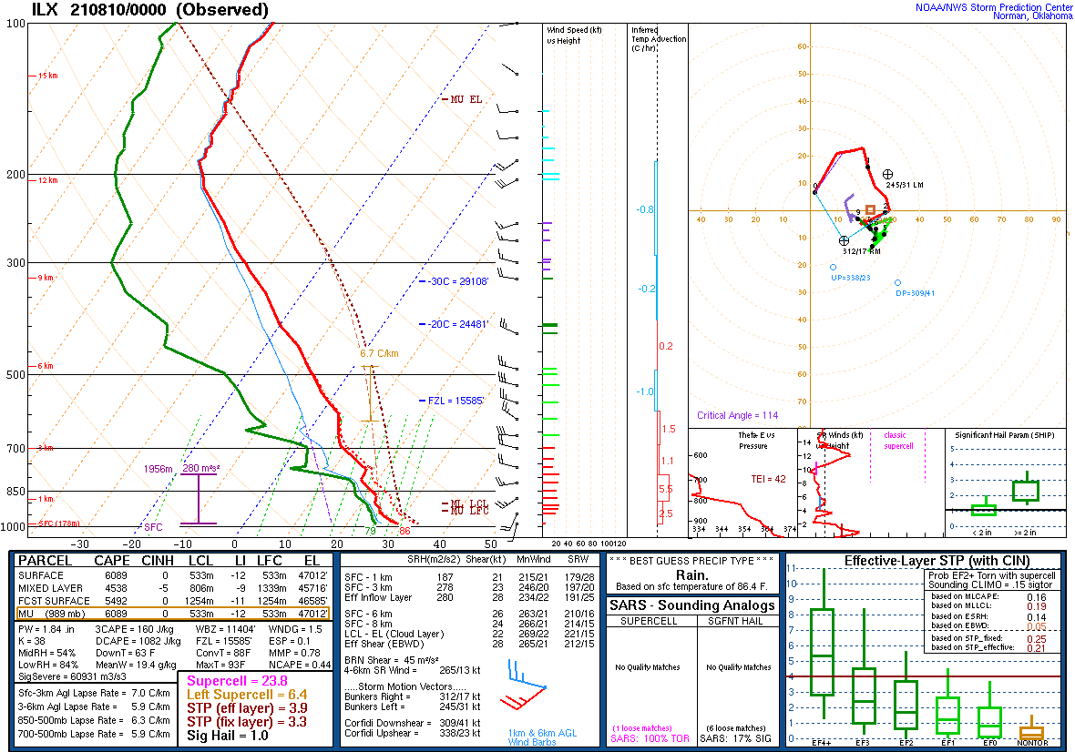 |
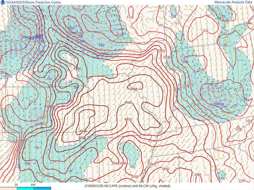 |
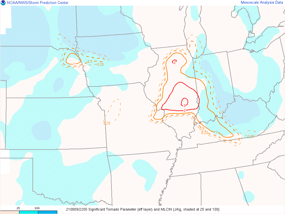 |
| Vertical sounding at Lincoln, Illinois taken at 7 PM on August 9th indicating considerable instability. Effective SRH--a measure of 'spin' available for storms--is 280 m2/s2, sufficiently high to support tornadoes. | Mixed Layer CAPE analysis from the SPC mesoanalysis valid at 5 PM. | Effective Significant Tornado Parameter from the SPC mesoanalysis. Values above 1-2 suggest an environment conducive for tornadic thunderstorms. |
Additional Info
 |
Media use of NWS Web News Stories is encouraged! Please acknowledge the NWS as the source of any news information accessed from this site. Additional recaps can be found on the NWS Chicago Past Events Page |
|


.png)
.png)
.png)