
Record setting heat is expected over the next several days from the Intermountain West through the northern Plains. Furthermore, fire weather concerns increase with dry and breezy conditions. Meanwhile, heavy rainfall and severe thunderstorm threats for the Ohio/Tennessee Valleys, central Appalachians and Southeast today. The threat shifts to central Gulf Coast and across central Texas this week. Read More >
|
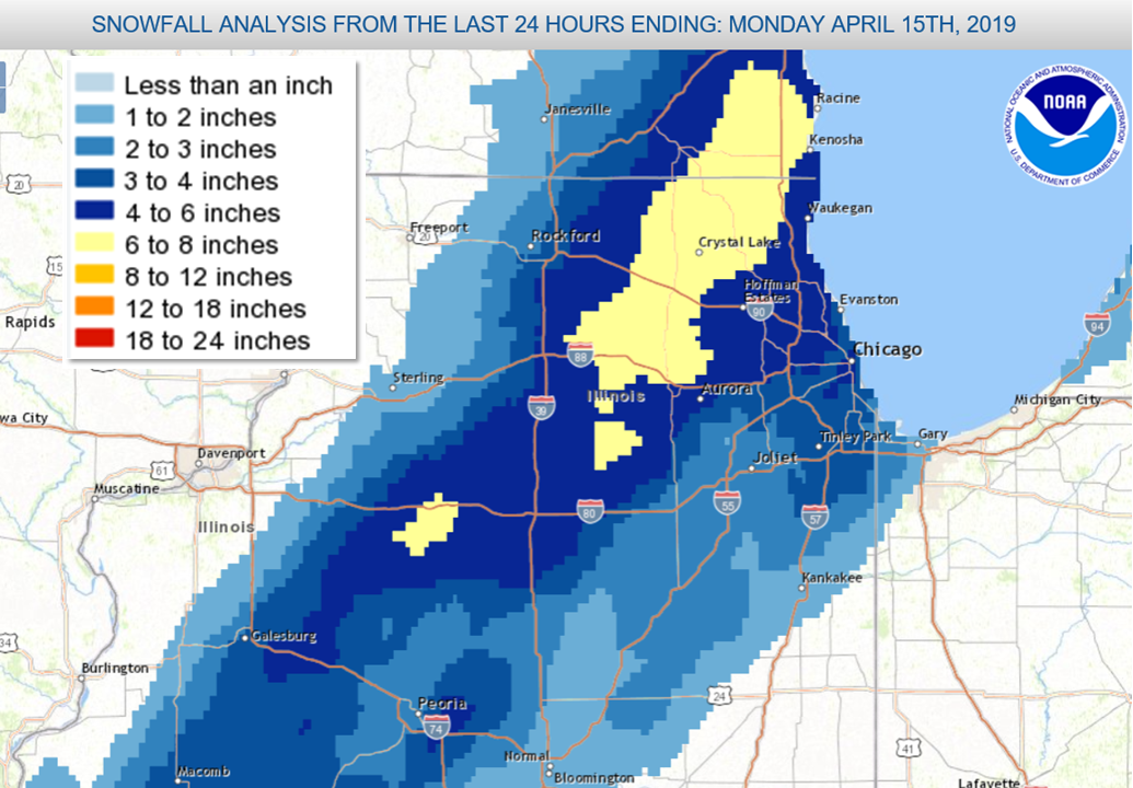
A very late season storm system produced heavy wet snow across much of northern Illinois, along with a winter mix of rain, sleet and snow over northwestern Indiana on Sunday April 14. As much as 6 to 8 inches of snow were reported in a narrow corridor from DeKalb County into the far northwest suburbs of Chicago. Lighter amounts of 2 to 5 inches were common elsewhere across northern Illinois. A total of 5.4 inches was reported at Chicago (O'Hare Airport) for the day. This was a daily snowfall record for April 14. Additionally, it ranks as the second latest date in the season with daily snowfall amounts exceeding 5 inches in Chicago. Only April 16th of 1961 was a later date with snowfall amounts also reaching 5.4 inches. In Rockford a total of 2.9 inches was reported for the day. This was not a record daily snowfall for Rockford. However, this ranks as the 5th snowiest event this late in the season in Rockford's history. |
 Observed Snowfall Amounts |
Fast Facts
Storm Reports

Map of Snowfall Local Storm Reports
PRELIMINARY LOCAL STORM REPORT...SUMMARY
NATIONAL WEATHER SERVICE CHICAGO IL
912 PM CDT SUN APR 14 2019

..TIME...   ...EVENT...      ...CITY LOCATION...     ...LAT.LON...
..DATE...   ....MAG....      ..COUNTY LOCATION..ST.. ...SOURCE....
            ..REMARKS..

0909 PM     SNOW             NWS CHICAGO-ROMEOVILLE  41.60N 88.08W
04/14/2019  M2.5 INCH        WILL               IL   OFFICIAL NWS OBS


0100 AM     SNOW             OHARE AIRPORT           41.98N 87.90W
04/15/2019  M5.4 INCH        COOK               IL   OFFICIAL NWS OBS


0856 PM     SNOW             BATAVIA                 41.85N 88.31W
04/14/2019  M5.2 INCH        KANE               IL   CO-OP OBSERVER


0844 PM     SNOW             1 S ELBURN              41.87N 88.47W
04/14/2019  M7.5 INCH        KANE               IL   PUBLIC


0700 PM     SNOW             ROCKFORD AIRPORT        42.20N 89.10W
04/14/2019  M2.9 INCH        WINNEBAGO          IL   OFFICIAL NWS OBS

            STORM TOTAL SNOWFALL. 1.5 INCHES OVER THE
            PAST 6 HOURS.

0100 AM     SNOW             3 SW MIDWAY AIRPORT     41.74N 87.78W
04/15/2019  M4.4 INCH        COOK               IL   CO-OP OBSERVER

            STORM TOTAL SNOWFALL. 0.75 INCHES OF LIQUID
            EQUIVALENT.

0532 PM     SNOW             2 S MOUNT PROSPECT      42.04N 87.93W
04/14/2019  M5.4 INCH        COOK               IL   PUBLIC


0500 PM     SNOW             FOX LAKE                42.40N 88.18W
04/14/2019  M5.8 INCH        LAKE               IL   PUBLIC

            REPORT VIA SOCIAL MEDIA.

0500 PM     SNOW             ROCHELLE                41.92N 89.07W
04/14/2019  E5.5 INCH        OGLE               IL   BROADCAST MEDIA


0500 PM     SNOW             BELVIDERE               42.26N 88.84W
04/14/2019  E4.0 INCH        BOONE              IL   BROADCAST MEDIA


0500 PM     SNOW             MONROE CENTER           42.10N 89.00W
04/14/2019  E3.5 INCH        OGLE               IL   BROADCAST MEDIA


0500 PM     SNOW             BYRON                   42.13N 89.26W
04/14/2019  E2.0 INCH        OGLE               IL   BROADCAST MEDIA


0418 PM     SNOW             PEOTONE                 41.33N 87.79W
04/14/2019  M2.6 INCH        WILL               IL   COCORAHS


0400 PM     SNOW             HARWOOD HEIGHTS         41.97N 87.80W
04/14/2019  M3.8 INCH        COOK               IL   COCORAHS


0350 PM     SNOW             3 S DEKALB              41.89N 88.77W
04/14/2019  M7.4 INCH        DE KALB            IL   PUBLIC


0332 PM     SNOW             LIBERTYVILLE            42.28N 87.95W
04/14/2019  M4.7 INCH        LAKE               IL   TRAINED SPOTTER

            CORRECTS PREVIOUS HEAVY SNOW REPORT FROM
            LIBERTYVILLE.

0330 PM     SNOW             2 NW ITASCA             41.99N 88.03W
04/14/2019  M5.5 INCH        COOK               IL   COCORAHS


0315 PM     SNOW             1 NNW MARENGO           42.27N 88.62W
04/14/2019  M5.5 INCH        MCHENRY            IL   COCORAHS


0755 PM     HEAVY SNOW       WOODSTOCK               42.31N 88.45W
04/14/2019  M8.5 INCH        MCHENRY            IL   CO-OP OBSERVER

            0.62 LIQUID.

0518 PM     HEAVY SNOW       DEKALB                  41.93N 88.75W
04/14/2019  M7.5 INCH        DE KALB            IL   TRAINED SPOTTER


0500 PM     HEAVY SNOW       SYCAMORE                41.99N 88.69W
04/14/2019  E8.0 INCH        DE KALB            IL   BROADCAST MEDIA


0346 PM     HEAVY SNOW       HUNTLEY                 42.18N 88.43W
04/14/2019  M7.5 INCH        MCHENRY            IL   BROADCAST MEDIA


&&
 |
Media use of NWS Web News Stories is encouraged! Additional recaps can be found on the NWS Chicago Science & Past Events Page. |
|

