
Record setting heat is expected over the next several days from the Intermountain West through the northern Plains. Furthermore, fire weather concerns increase with dry and breezy conditions. Meanwhile, heavy rainfall and severe thunderstorm threats for the Ohio/Tennessee Valleys, central Appalachians and Southeast today. The threat shifts to central Gulf Coast and across central Texas this week. Read More >
Overview
|
Sunday, January 7 saw persistent light freezing rain and drizzle over the area over a span of six to nine hours. At brief times this was mixed with sleet and snow, but was mainly an icing event during the afternoon. After dark, the precipitation gradually transitioned to snow by mid-evening. This event came on the heels of a significant cold weather period from Dec 26-Jan 6, which meant ground and pavement temperatures were below freezing. This furthered the icing on roads and created very hazardous travel conditions. A Winter Weather Advisory was issued for generally south of Interstate 80 in the early morning of January 7, and this was expanded northward early in the afternoon.
|
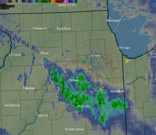 January 7 13-hour radar loop from 10:30 a.m.-11:30 p.m. Overlaid in yellow are mPing observations. Symbols are drops (rain), drops with a horizontal "S" (freezing rain), S with a circle (sleet), and asterisk shape (snow). |
Ice Accretion
PRELIMINARY LOCAL STORM REPORT
NATIONAL WEATHER SERVICE CHICAGO/ROMEOVILLE IL
220 AM CST MON JAN 08 2018

..TIME...   ...EVENT...      ...CITY LOCATION...     ...LAT.LON...
..DATE...   ....MAG....      ..COUNTY LOCATION..ST.. ...SOURCE....
            ..REMARKS..

1200 AM     FREEZING RAIN    OHARE AIRPORT           41.98N 87.90W
01/08/2018  M0.05 INCH       COOK               IL   ASOS

            ICE ACCRETION FOR JANUARY 7TH.

1200 AM     FREEZING RAIN    MIDWAY AIRPORT          41.78N 87.75W
01/08/2018  M0.01 INCH       COOK               IL   ASOS

            ICE ACCRETION FOR JANUARY 7TH.

1200 AM     FREEZING RAIN    ROCKFORD AIRPORT        42.20N 89.10W
01/08/2018  M0.10 INCH       WINNEBAGO          IL   ASOS

            ICE ACCRETION FOR JANUARY 7TH.

1200 AM     FREEZING RAIN    WEST CHICAGO            41.89N 88.22W
01/08/2018  M0.12 INCH       DUPAGE             IL   ASOS

            ICE ACCRETION FOR JANUARY 7TH AT DUPAGE AIRPORT.

1200 AM     FREEZING RAIN    WHEELING                42.13N 87.92W
01/08/2018  M0.01 INCH       COOK               IL   ASOS

            ICE ACCRETION FOR JANUARY 7TH AT CHICAGO EXECUTIVE
            AIRPORT.

1200 AM     FREEZING RAIN    SUGAR GROVE             41.77N 88.46W
01/08/2018  M0.08 INCH       KANE               IL   ASOS

            ICE ACCRETION FOR JANUARY 7TH AT AURORA AIRPORT.

1200 AM     FREEZING RAIN    VALPARAISO              41.48N 87.05W
01/08/2018  M0.07 INCH       PORTER             IN   ASOS

            ICE ACCRETION FOR JANUARY 7TH AT PORTER COUNTY REGIONAL
            AIRPORT.

1200 AM     FREEZING RAIN    WAUKEGAN                42.37N 87.87W
01/08/2018  M0.03 INCH       LAKE               IL   ASOS

            ICE ACCRETION FOR JANUARY 7TH.

1200 AM     FREEZING RAIN    ROMEOVILLE              41.65N 88.09W
01/08/2018  E0.08 INCH       WILL               IL   OFFICIAL NWS OBS

            ICE ACCRETION FOR JANUARY 7TH AT NWS CHICAGO.


&&

$$

RC
Meteorology
 |
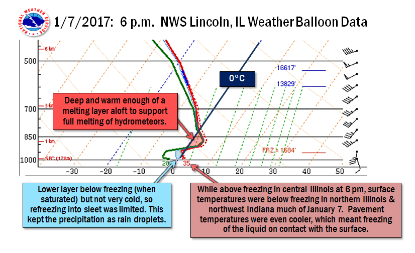 |
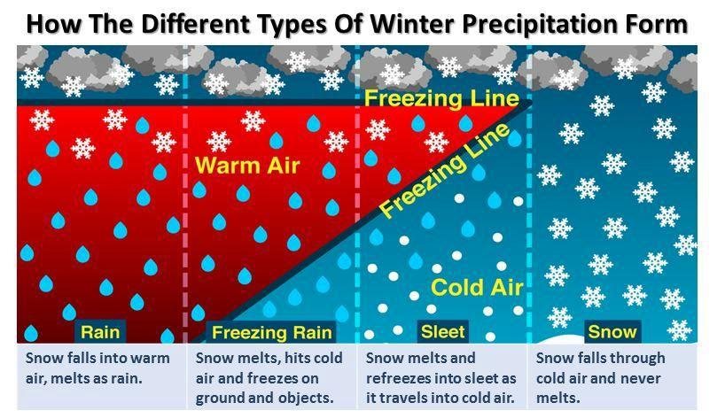
| An explanation of different precipitation types. | A look at the observed atmosphere over central Illinois on January 7 that was representative of much of the local area. |
 |
Media use of NWS Web News Stories is encouraged! |
|

