Record setting heat is expected over the next several days from the Intermountain West through the northern Plains. Furthermore, fire weather concerns increase with dry and breezy conditions. Meanwhile, heavy rainfall and severe thunderstorm threats for the Ohio/Tennessee Valleys, central Appalachians and Southeast today. The threat shifts to central Gulf Coast and across central Texas this week. Read More >
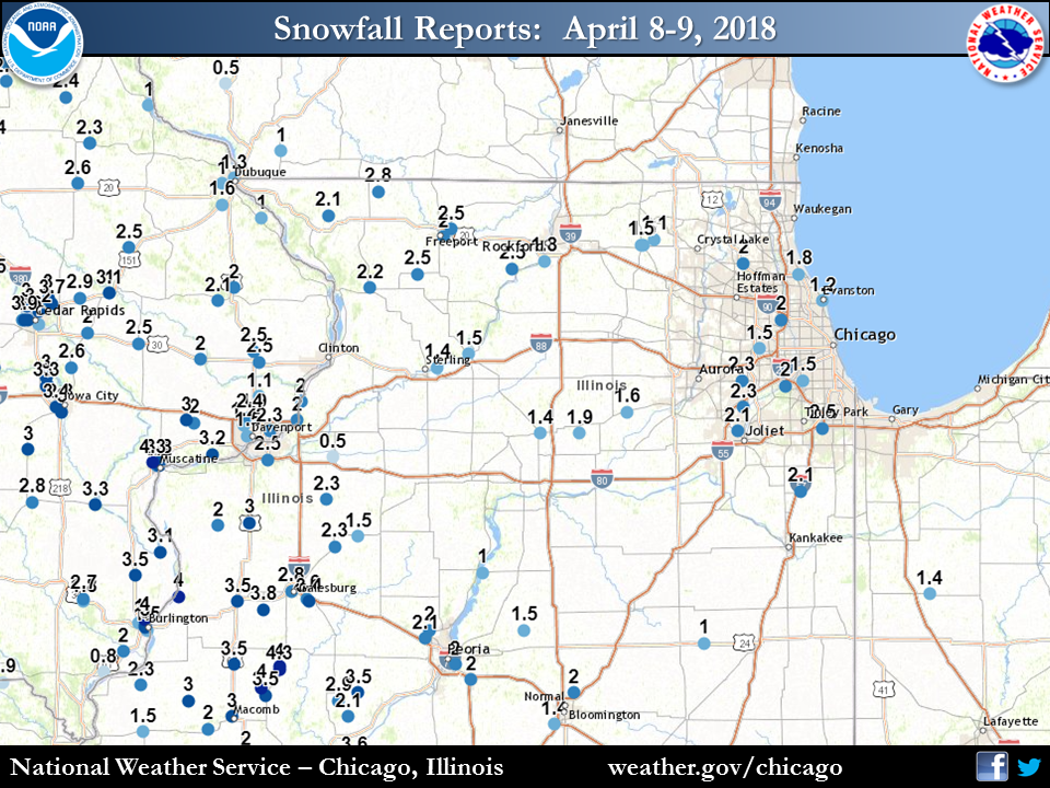
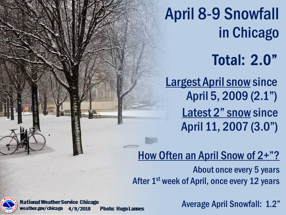
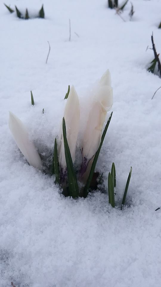
| Snow moved into the area late Sunday evening April 8 and continued through the early morning hours of Monday April 9. Isolated snow showers developed during the afternoon of the 9th. Accumulations across northeast Illinois and northwest Indiana ranged from 0.5" to 2.5". The snow was a higher ratio of snow-to-water, especially for April, led to the fluffy accumulations. These accumulations were almost entirely on grass, trees, and elevated surfaces, while most pavement was too warm for accumulation, though some slick spots this morning were reported (likely from melting snow refreezing). |
|
Fast Facts
 |
| April 8-9 Snowfall Facts |
More on April snow normals and records can be found here, while late season snow climatology here.
Snow Totals
Public Information Statement
National Weather Service Chicago IL
0611 PM CDT Mon Apr 09 2018

...April 8-9 Snowfall Roundup...

   The following are snow amounts for the previous 24 hours
   as measured in the morning by NWS Cooperative Observers
   and CoCoRaHS observers.
   Observations are usually taken at 7 AM.

   24-hour Snowfall Amounts for Monday(04/09/18)...


Northern Illinois                              Snow
  Location (County):                           fall(inches)

  Homer Glen 1ENE (Will)........................2.8
  Homewood (Cook)...............................2.5
  Byron 3N (Ogle)...............................2.5
  New Lenox 2SE (Will)..........................2.5
  Palos Park 1SW (Cook).........................2.4
  New Lenox 3E (Will)...........................2.4
  Naperville 2ESE (Du Page).....................2.3
  Elburn (Kane).................................2.3
  Lincolnshire 1N (Lake)........................2.3
  Lockport 1SE (Will)...........................2.3
  Romeoville (Will).............................2.3
  Coal City (Grundy)............................2.2
  Plainfield 2SSE (Will)........................2.2
  Downers Grove 0.4NNE (Du Page)................2.1
  Naperville 1NW (Du Page)......................2.1
  Peotone (Will)................................2.1
  Joliet 2n (Will)..............................2.1
  Peotone (Will)................................2.1
  Elburn (Kane).................................2.0
  De Kalb 1SW (De Kalb).........................2.0
  Aurora 4SE (Du Page)..........................2.0
  Lisle 1SE (Du Page)...........................2.0
  Oswego 5SSE (Kendall).........................2.0
  Sugar Grove 1NE (Kane)........................2.0
  Geneva 4WSW (Kane)............................2.0
  Batavia 2WNW (Kane)...........................2.0
  Elburn (Kane).................................2.0
  North Aurora 2NE (Kane).......................2.0
  Geneva 1SSW (Kane)............................2.0
  Buffalo Grove 2N (Lake).......................2.0
  Highwood 1S (Lake)............................2.0
  Manhattan 5ENE (Will).........................2.0
  Manhattan 1ESE (Will).........................2.0
  Wilmington 3SE (Will).........................2.0
  New Lenox 4SE (Will)..........................2.0
  Lake Zurich (Lake)............................2.0
  Manhattan (Will)..............................2.0
  Willow Springs (Cook).........................2.0
  Elgin (Kane)..................................1.9
  Earlville 3S (La Salle).......................1.9
  Elmhurst 1ESE (Du Page).......................1.9
  Montgomery 1SSE (Kendall).....................1.9
  Elgin 1S (Kane)...............................1.9
  Naperville 4SSW (Will)........................1.9
  Mundelein (Lake)..............................1.9
  Plainfield (Will).............................1.9
  Botanic Gardens (Cook)........................1.8
  Fox Lake 2SE (Lake)...........................1.8
  Lake Villa 2WSW (Lake)........................1.8
  Bull Valley 2WNW (McHenry)....................1.8
  Woodstock 4SW (McHenry).......................1.8
  Batavia (Kane)................................1.7
  Genoa (De Kalb)...............................1.7
  Worth (Cook)..................................1.7
  Naperville 2ESE (Du Page).....................1.7
  Aurora 4NE (Du Page)..........................1.7
  Plainfield 5SW (Kendall)......................1.7
  Batavia 1WNW (Kane)...........................1.7
  Dixon 3NNW (Lee)..............................1.7
  Huntley (McHenry).............................1.7
  St. Charles 6NW (Kane)........................1.6
  La Salle (La Salle)...........................1.6
  Crete 3E (Will)...............................1.6
  Westmont (Du Page)............................1.6
  Dixon (Lee)...................................1.5
  Hoffman Estates 5W (Cook).....................1.5
  Bridgeview 1NNW (Cook)........................1.5
  Chicago 6ESE (Cook)...........................1.5
  Oak Lawn (Cook)...............................1.5
  Oak Lawn 2WNW (Cook)..........................1.5
  Oak Park 1NNE (Cook)..........................1.5
  De Kalb (De Kalb).............................1.5
  Darien (Du Page)..............................1.5
  Westmont 1SSW (Du Page).......................1.5
  Elmhurst (Du Page)............................1.5
  Naperville 2SE (Du Page)......................1.5
  Morris 6ESE (Grundy)..........................1.5
  Lily Lake 2E (Kane)...........................1.5
  St. Charles (Kane)............................1.5
  Elgin 2W (Kane)...............................1.5
  Riverwoods (Lake).............................1.5
  Gurnee 2W (Lake)..............................1.5
  Mundelein (Lake)..............................1.5
  Machesney Park 3ENE (Winnebago)...............1.5
  Park Forest (Cook)............................1.5
  Woodstock 5nw (McHenry).......................1.5
  De Kalb (De Kalb).............................1.4
  Chicago Ridge (Cook)..........................1.4
  Park Ridge (Cook).............................1.4
  La Grange Park 1SSW (Cook)....................1.4
  Cortland (De Kalb)............................1.4
  Elmhurst 2SE (Du Page)........................1.4
  Wonder Lake 1WNW (McHenry)....................1.4
  Cary (McHenry)................................1.4
  Rockford 1NW (Winnebago)......................1.4
  Lansing (Cook)................................1.4
  Mendota (La Salle)............................1.4
  Yorkville 2SE (Kendall).......................1.4
  Bourbonnais (Kankakee)........................1.3
  Harwood Heights (Cook)........................1.3
  Mount Prospect 3NE (Cook).....................1.3
  Elk Grove Village 1ESE (Cook).................1.3
  Peru 1ENE (La Salle)..........................1.3
  Cary (McHenry)................................1.3
  Momence (Kankakee)............................1.3
  Crystal Lake 1WSW (McHenry)...................1.2
  Oak Park 2S (Cook)............................1.2
  Palatine 1NNE (Cook)..........................1.2
  Park Forest 1NNE (Cook).......................1.2
  Dwight 4NNW (Grundy)..........................1.2
  Ottawa 2N (La Salle)..........................1.2
  Roscoe 2ESE (Winnebago).......................1.2
  Roscoe 2se (Winnebago)........................1.2
  Coal City 4NNW (Grundy).......................1.1
  Carbon Hill 3.1N (Grundy).....................1.1
  Kankakee 4WNW (Kankakee)......................1.1
  Belvidere (Boone).............................1.0
  Chatsworth (Livingston).......................1.0
  Elgin (Kane)..................................1.0
  Hebron (McHenry)..............................1.0
  Harvard (McHenry).............................1.0
  Rogers Park 2SW (Cook)........................1.0
  Somonauk 2NE (De Kalb)........................1.0
  Glen Ellyn 1WSW (Du Page).....................1.0
  Roselle 1ESE (Du Page)........................1.0
  Mazon 0.5ENE (Grundy).........................1.0
  Herscher 3E (Kankakee)........................1.0
  Sterling 4NE (Lee)............................1.0
  Seneca 2SSW (La Salle)........................1.0
  Sheridan 3SSE (La Salle)......................1.0
  Chatsworth (Livingston).......................1.0
  Algonquin 1N (McHenry)........................1.0
  Rockford 2ENE (Winnebago).....................1.0
  Midway Coop (Cook)............................1.0
  Morris (Grundy)...............................1.0
  Ottawa (La Salle).............................1.0
  Paxton (Ford).................................1.0
  St Anne (Kankakee)............................1.0
  Park Ridge 1WNW (Cook)........................0.9
  Countryside 1ENE (Cook).......................0.9
  Waukegan 2N (Lake)............................0.9
  Elk Grove Village 2WSW (Cook).................0.8
  Watseka 6.9WNW (Iroquois).....................0.8
  Bonfield 4WSW (Kankakee)......................0.8
  Lake Villa 1SSW (Lake)........................0.8
  Schaumburg 2E (Cook)..........................0.7
  Wheaton 2NNE (Du Page)........................0.7
  Ashkum 5.6E (Iroquois)........................0.6
  Ashton (Lee)..................................0.6
  Streator 4ENE (La Salle)......................0.6
  Steward (Lee).................................0.6
  Dwight (Livingston)...........................0.5
  Capron (Boone)................................0.5
  Winnetka 1ESE (Cook)..........................0.5
  Glen Ellyn 2SSE (Du Page).....................0.5
  Paxton (Ford).................................0.5
  Kankakee (Kankakee)...........................0.5
  Streator (Livingston).........................0.5
  McHenry (McHenry).............................0.2
  Barrington (Lake).............................0.1
  Marseilles (La Salle).........................0.1
  Rochelle (Ogle)...............................0.1

Northwest Indiana                              Snow
  Location (County):                           fall(inches)

  Lake Village (Newton).........................2.1
  Wheatfield 3S (Jasper)........................2.0
  De Motte 4SW (Jasper).........................2.0
  (w9mal)Merrillville 2NNW (Lake)...............2.0
  Remington (Jasper)............................1.9
  Munster 2NNW (Lake)...........................1.7
  Mount Ayr 2NNE (Newton).......................1.7
  Hebron 4NE (Porter)...........................1.7
  Dyer 1WNW (Lake)..............................1.6
  Lakes Of The Four Seasons 2NNE (Porter).......1.6
  De Motte 6S (Jasper)..........................1.5
  Crown Point 2WSW (Lake).......................1.5
  (kb9f)Valparaiso 4S (Porter)..................1.5
  Valparaiso 2WNW (Porter)......................1.5
  Valparaiso 6WSW (Porter)......................1.5
  Chesterton 4E (Porter)........................1.5
  Rensselaer (Jasper)...........................1.4
  De Motte 1NNW (Jasper)........................1.3
  Kentland (Newton).............................1.2
  Valparaiso 2NW (Porter).......................1.1
  (w9opr)Wheatfield 1ENE (Jasper)...............1.0
  Valparaiso 6SSW (Porter)......................1.0
  Valparaiso 4SW (Porter).......................1.0
  Portage 1ESE (Porter).........................1.0
  Porter 1S (Porter)............................1.0
  Morocco (Newton)..............................1.0
  St. John (Lake)...............................0.6
  Crown Point (Lake)............................0.5
  Crown Point 1N (Lake).........................0.5
  Hebron 1NE (Porter)...........................0.5
  Portage 3E (Porter)...........................0.5
  Valparaiso 2WSW (Porter)....................TRACE
  Valparaiso 1SE (Porter).....................TRACE
Storm Reports
PRELIMINARY LOCAL STORM REPORT...SUMMARY
NATIONAL WEATHER SERVICE CHICAGO/ROMEOVILLE IL
552 PM CDT MON APR 09 2018

..TIME...   ...EVENT...      ...CITY LOCATION...     ...LAT.LON...
..DATE...   ....MAG....      ..COUNTY LOCATION..ST.. ...SOURCE....
            ..REMARKS..

1124 AM     SNOW             OHARE AIRPORT           41.98N 87.90W
04/09/2018  M2.0 INCH        COOK               IL   OFFICIAL NWS OBS

            STORM TOTAL

1102 AM     SNOW             3 SW MIDWAY AIRPORT     41.75N 87.79W
04/09/2018  M1.5 INCH        COOK               IL   CO-OP OBSERVER

            STORM TOTAL. WATER EQUIVALENT 0.12.

0800 AM     SNOW             3 S EARLVILLE           41.55N 88.92W
04/09/2018  M1.9 INCH        LA SALLE           IL   CO-OP OBSERVER

0800 AM     SNOW             DIXON                   41.85N 89.48W
04/09/2018  M1.5 INCH        LEE                IL   CO-OP OBSERVER

0800 AM     SNOW             3 S WHEATFIELD          41.15N 87.05W
04/09/2018  M0.0 INCH        JASPER             IN   COCORAHS

0800 AM     SNOW             3 ESE NAPERVILLE        41.75N 88.10W
04/09/2018  M2.3 INCH        DUPAGE             IL   COCORAHS

0800 AM     SNOW             3 N UNION               42.28N 88.54W
04/09/2018  M1.1 INCH        MCHENRY            IL   PUBLIC

            EVENT TOTAL SO FAR RELAYED VIA SOCIAL MEDIA.

0800 AM     SNOW             LOMBARD                 41.87N 88.01W
04/09/2018  E1.5 INCH        DUPAGE             IL   BROADCAST MEDIA

            ESTIMATED EVENT TOTAL SO FAR RELAYED VIA SOCIAL MEDIA.

0800 AM     SNOW             WILLOW SPRINGS          41.73N 87.88W
04/09/2018  M2.0 INCH        COOK               IL   CO-OP OBSERVER

0800 AM     SNOW             2 NE NORTHBROOK         42.15N 87.81W
04/09/2018  M1.8 INCH        COOK               IL   CO-OP OBSERVER

0800 AM     SNOW             RENSSELAER              40.94N 87.15W
04/09/2018  M1.4 INCH        JASPER             IN   CO-OP OBSERVER

0800 AM     SNOW             PEOTONE                 41.33N 87.80W
04/09/2018  M2.1 INCH        WILL               IL   CO-OP OBSERVER

0800 AM     SNOW             3 N BYRON               42.17N 89.26W
04/09/2018  M2.5 INCH        OGLE               IL   COCORAHS

0800 AM     SNOW             CHATSWORTH              40.75N 88.29W
04/09/2018  M1.0 INCH        LIVINGSTON         IL   CO-OP OBSERVER

0800 AM     SNOW             HAZEL CREST             41.57N 87.69W
04/09/2018  M2.5 INCH        COOK               IL   TRAINED SPOTTER

            EVENT TOTAL SO FAR RELAYED VIA SOCIAL MEDIA.

0800 AM     SNOW             MENDOTA                 41.55N 89.12W
04/09/2018  M1.4 INCH        LA SALLE           IL   CO-OP OBSERVER

0800 AM     SNOW             LAKE ZURICH             42.19N 88.09W
04/09/2018  M2.0 INCH        LAKE               IL   CO-OP OBSERVER

0720 AM     SNOW             EVANSTON                42.05N 87.69W
04/09/2018  M1.2 INCH        COOK               IL   BROADCAST MEDIA

0700 AM     SNOW             1 N MARENGO             42.26N 88.60W
04/09/2018  M1.5 INCH        MCHENRY            IL   COCORAHS

            TOTAL SO FAR.

0700 AM     SNOW             ROMEOVILLE              41.65N 88.09W
04/09/2018  M2.3 INCH        WILL               IL   OFFICIAL NWS OBS

            EVENT TOTAL SO FAR AT NWS CHICAGO.

0700 AM     SNOW             2 N JOLIET              41.56N 88.12W
04/09/2018  M2.1 INCH        WILL               IL   CO-OP OBSERVER

            SUPPLEMENTAL COOP OBSERVER AND RETIRED NWS EMPLOYEE.

0655 AM     SNOW             ROCKFORD AIRPORT        42.20N 89.10W
04/09/2018  M1.8 INCH        WINNEBAGO          IL   OFFICIAL NWS OBS

0600 AM     SNOW             SOMONAUK                41.63N 88.68W
04/09/2018  M1.6 INCH        DE KALB            IL   TRAINED SPOTTER

            RELAYED VIA SOCIAL MEDIA. ACCUMULATION ON GRASSY
            SURFACES.
Additional
Photos
 |
 |
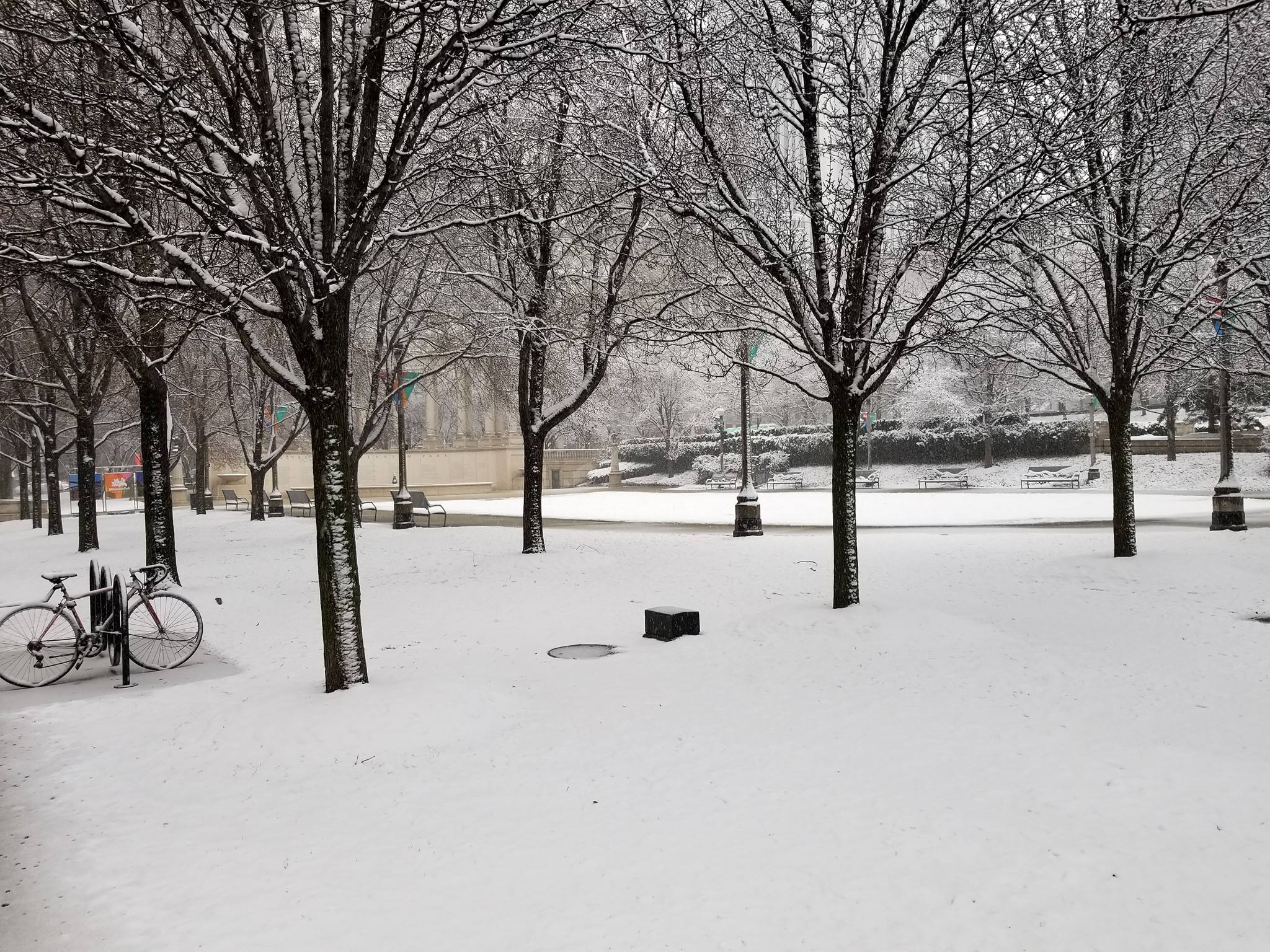 |
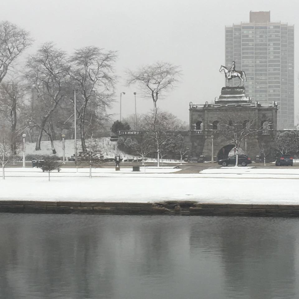
| NWS Chicago | Lincoln Park, photo courtesy of Christian Lyon. | Millenium Park in Chicago, photo courtesy of Hugo Lannes. |
 |
| Belvidere, courtesy of Pamela Hulton. |
Links
 |
Media use of NWS Web News Stories is encouraged! Additional recaps can be found on the NWS Chicago Science & Past Events Page. |
|